Perry-Castañeda Library
Map Collection
Syria Maps
The following maps were produced by the U.S. Central Intelligence Agency, unless otherwise indicated.
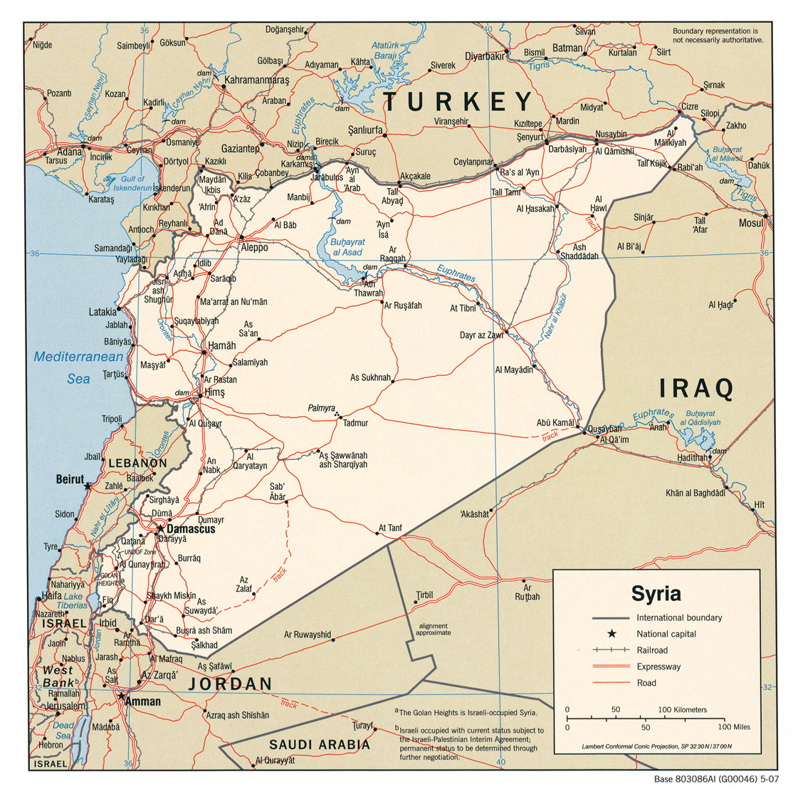
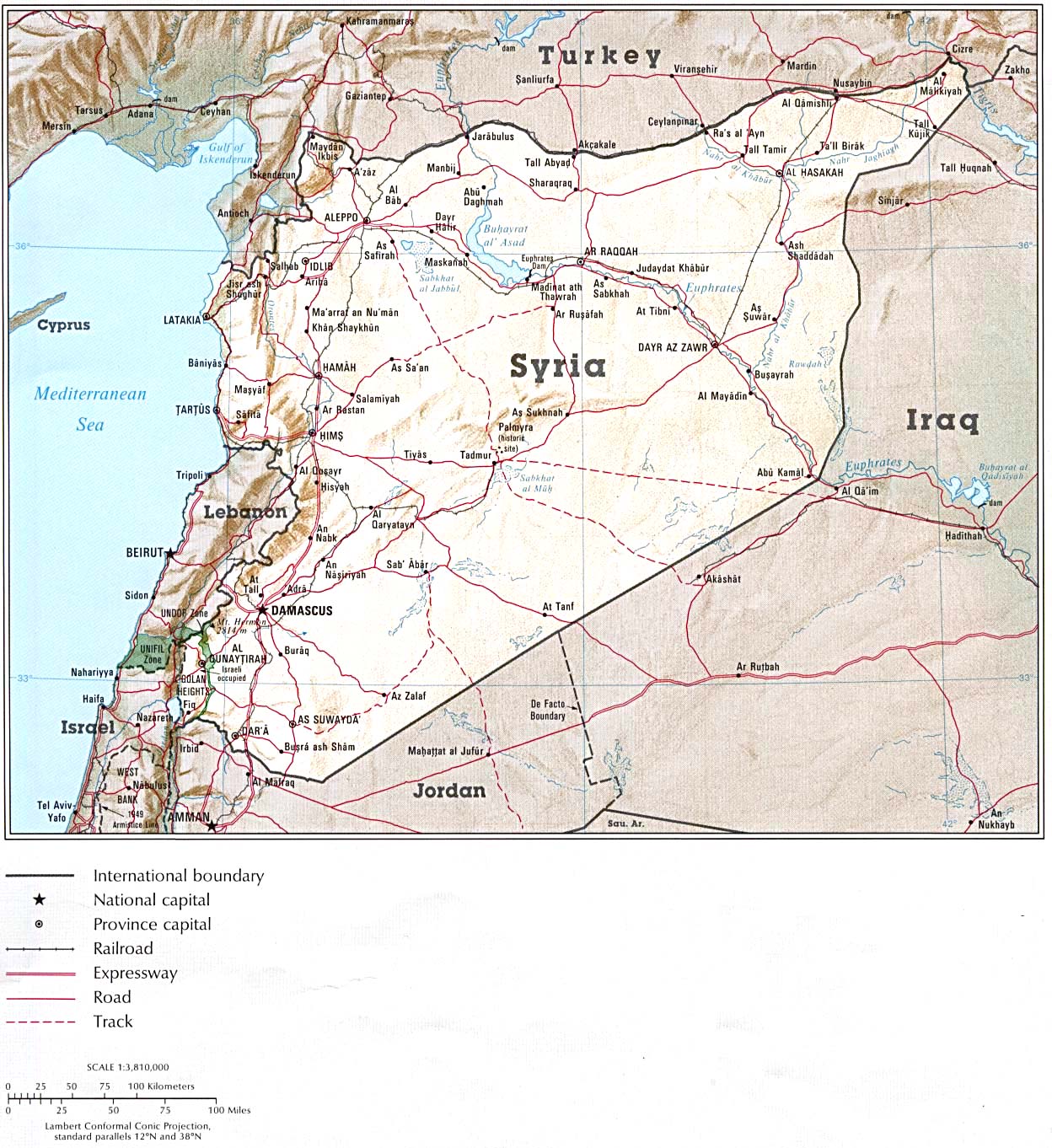
Country Maps- Syria (Political) 2007 (750K) and pdf format (388K)
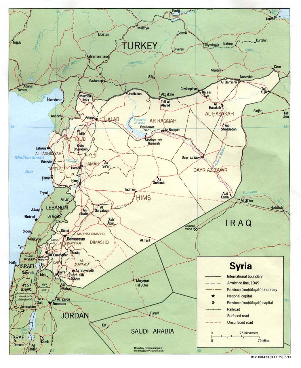
- Syria (Political) 1990 (240K) and pdf format (243K)
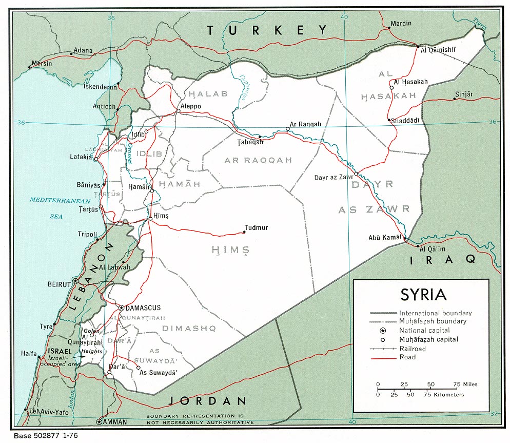
- Syria (Political) 1976 (240K) and pdf format (248K)
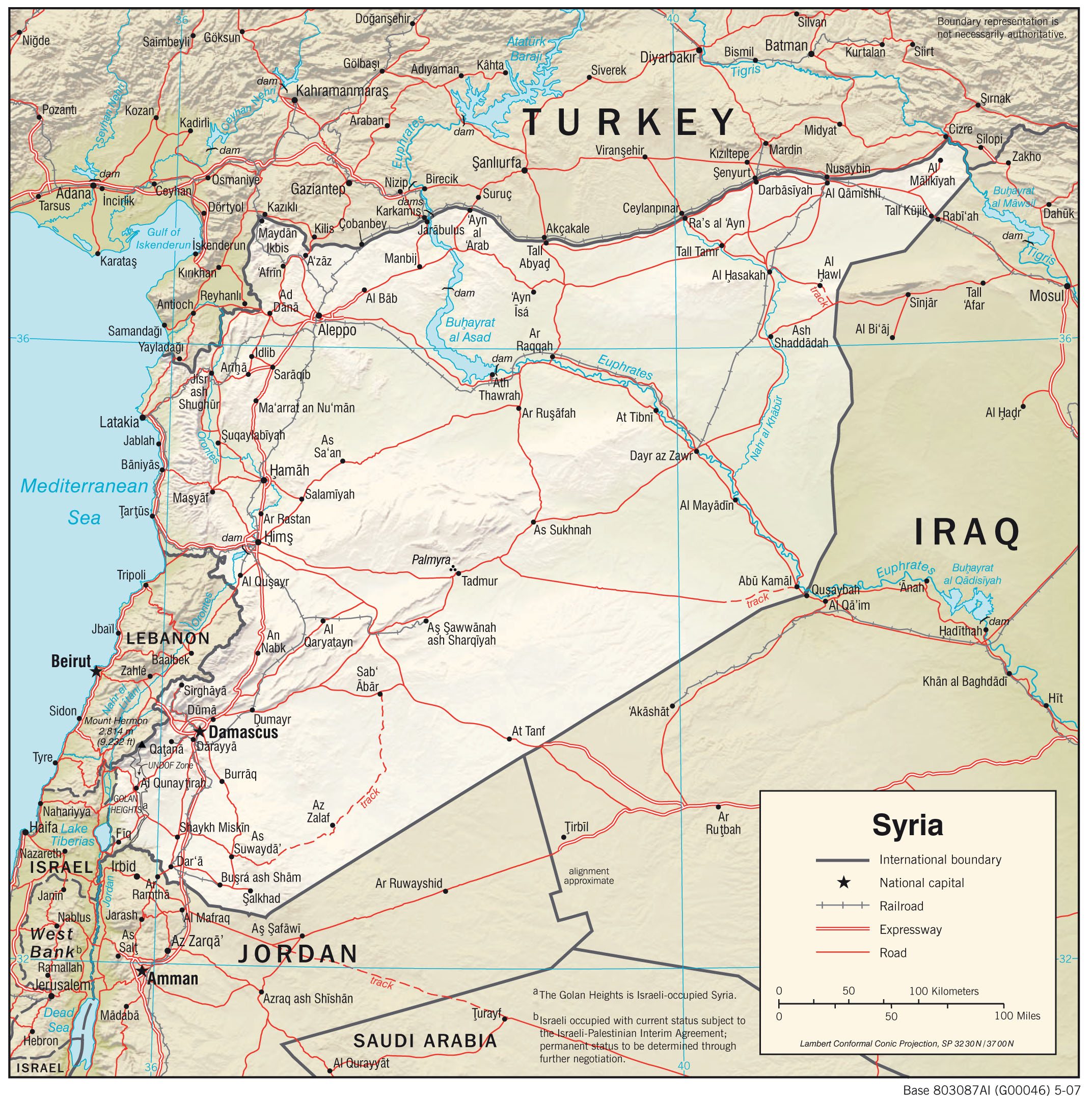
- Syria (Shaded Relief) 2007 (1.1MB) and pdf format (467K)
- Syria (Shaded Relief) From Atlas of the Middle East 1993 (339K) and pdf format (311K)
- Syria (Shaded Relief) 1990 (253K) and pdf format (261K)
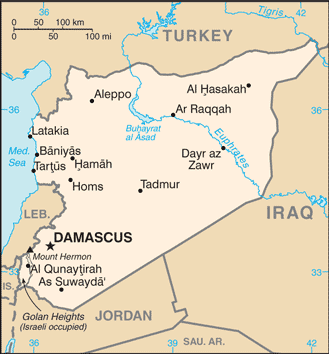
- Syria (Small Map) 2016 (22K)
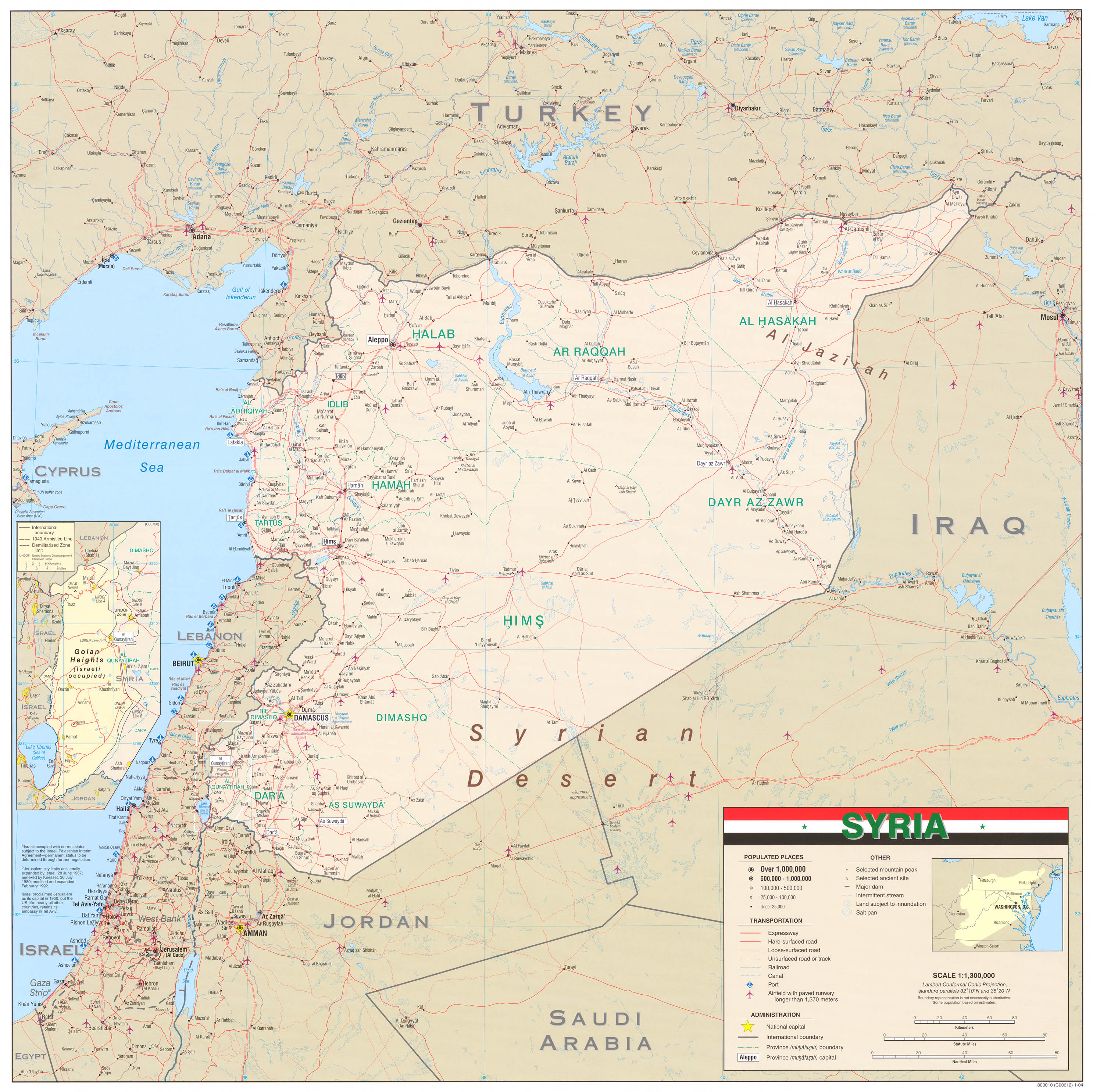
- Syria (Wall Map) 2004 (1.3MB)
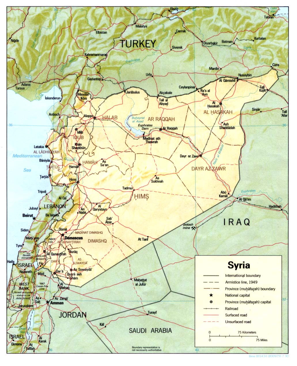
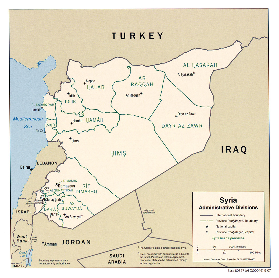
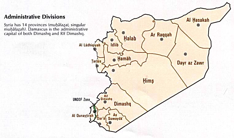
- Syria (Administrative Divisions) 2007 (510K) and pdf format (213K)
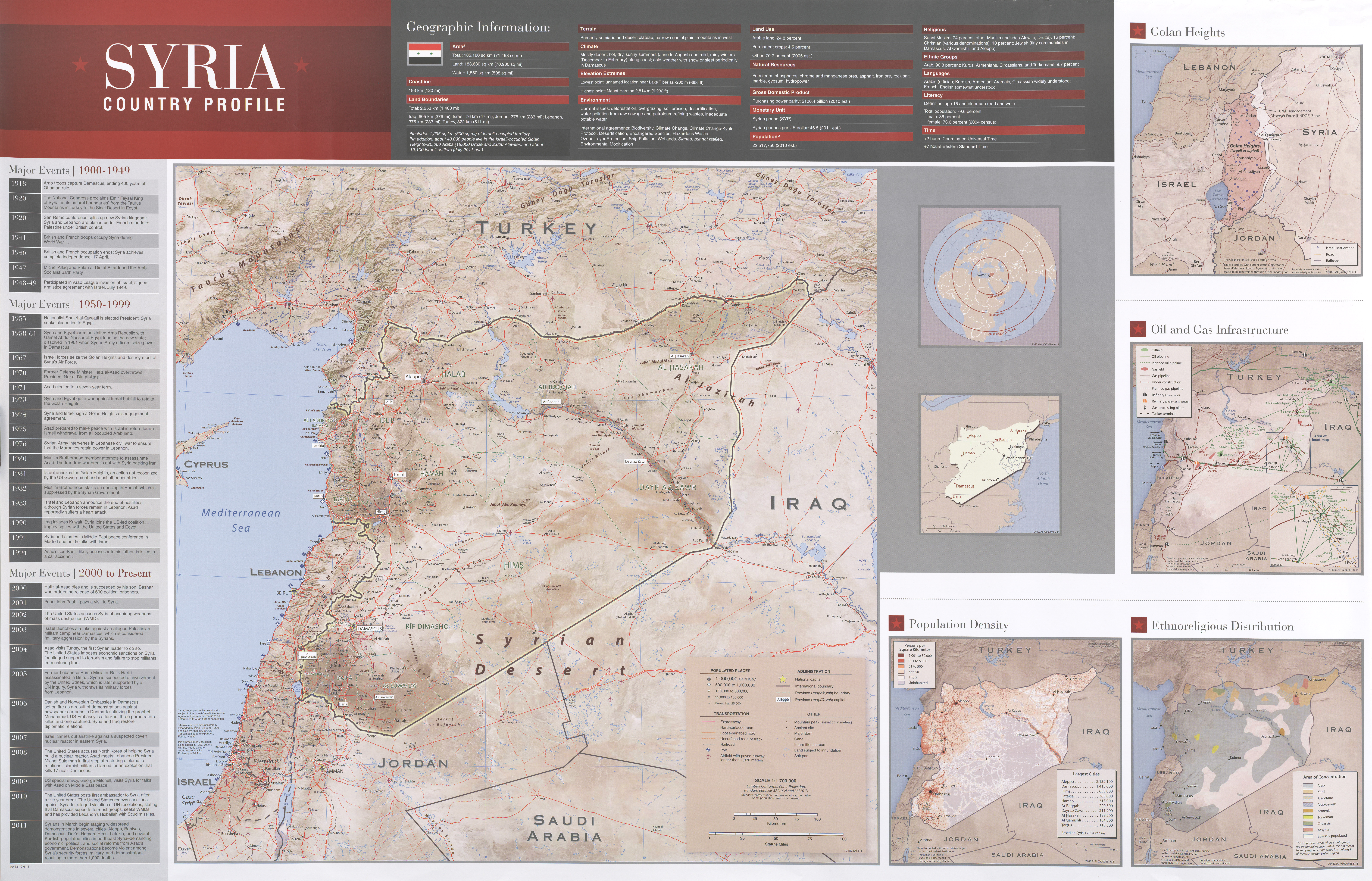
- Syria Country Profile 2011 (10.7MB)
- covers maps of Syria, Golan Heights, Syria Oil and Gas Infrastructure, Syria Population Density and Syria Ethnoreligious Distribution.
- Syria Region: Conflicts Without Borders U.S. Department of State. Humanitarian Information Unit, October 9, 2014 [pdf format] (8.9MB)
- covers maps of Syria, Golan Heights, Syria Oil and Gas Infrastructure, Syria Population Density and Syria Ethnoreligious Distribution.
- 1:1,000,000 - Middle East - Operational Navigation Chart U.S. National Imagery and Mapping Agency. Not for Navigational use
- Sheet G4 covers all of Syria.
- 1:2,000,000 - Mediterranee Orientale Series I205, U.S. Army Map Service, 1941
- The East Sheet covers all of Syria.
- 1:800,000 - Turkey Series K300 (4235), Great Britain War Office, 1941-
- This series covers part of northern Syria
- 1:500,000 - Tactical Pilotage Charts U.S. National Imagery and Mapping Agency. Not for navigational use
- This series covers all of Syria.
- 1:500,000 - World Series 1404, Great Britain. War Office and Air Ministry. 1958-
- This series covers all of Syria.
- 1:500,000 - Levant Series K421, U.S. Army Map Service, 1942-
- This series covers all of Syria.
- 1:250,000 - Syria - Joint Operations Graphic U.S. National Imagery and Mapping Agency. Not for Navigational use
- Nine maps cover parts of Syria.
- 1:250,000 - Southwestern Asia Series K502, U.S. Army Map Service, 1953-
- This series covers northern and eastern Syria.
- 1:200,000 - Syria Series K521, U.S. Army Map Service, 1941-
- 11 maps cover parts of Syria.
- Sheet G4 covers all of Syria.
- [Aleppo] Alep 1958 1:10,000, Edition 2-AMS, Series K922. U.S. Army Map Service, 1958 (4.4MB)
- [Damascus] Syria: Damascus Areas of Influence and Areas Reportedly Affected by 21 August Chemical Attack Issued by the White House Press Secretary on August 30, 2013 (526K) [PDF]
- [Damascus] Damas 1958 1:10,000, Edition 2-AMS, Series K922. U.S. Army Map Service, 1958 (6.2MB)
- Damascus [Damas] Central 1912 From Palestine and Syria...Handbook for Travellers by Karl Baedeker, 5th Edition, 1912. (374K)
![[Aleppo] Alep 1958](world_cities/txu-oclc-13214823-alep-1958.jpg)
![[Damascus] Damas 1958](world_cities/txu-oclc-44821944-damas-1958.jpg)
![Damascus [Damas] Central 1912](historical/damascus2_1912.jpg)
- Syria Region: Conflicts Without Borders U.S. Department of State. Humanitarian Information Unit, October 9, 2014 [pdf format] (8.9MB)
- Syria Country Profile 2011 (10.7MB)
- Covers maps of Syria, Golan Heights, Syria Oil and Gas Infrastructure, Syria Population Density and Syria Ethnoreligious Distribution.
- Administrative Divisions From Atlas of the Middle East, 1993 (52K)
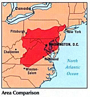
- Area Comparison From Atlas of the Middle East, 1993 (29K)
- Economic Activity From Atlas of the Middle East, 1993 (103K)
- Land Use From Atlas of the Middle East, 1993 (103K)
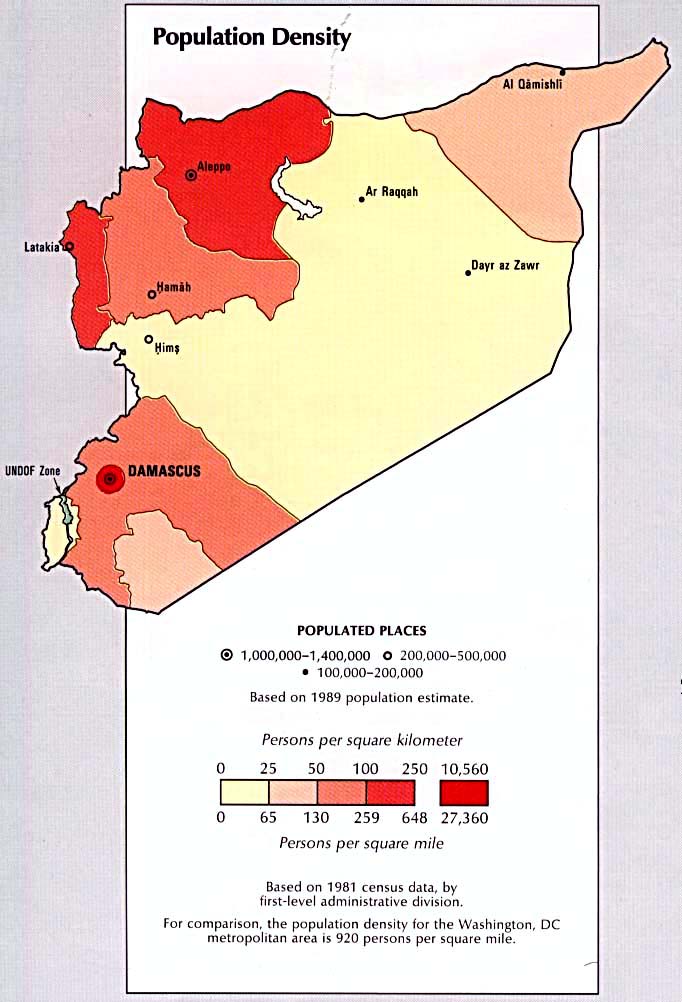
- Population Density From Atlas of the Middle East, 1993 (86K)
- Time Line From Atlas of the Middle East, 1993 (175K) Chart
- Covers maps of Syria, Golan Heights, Syria Oil and Gas Infrastructure, Syria Population Density and Syria Ethnoreligious Distribution.
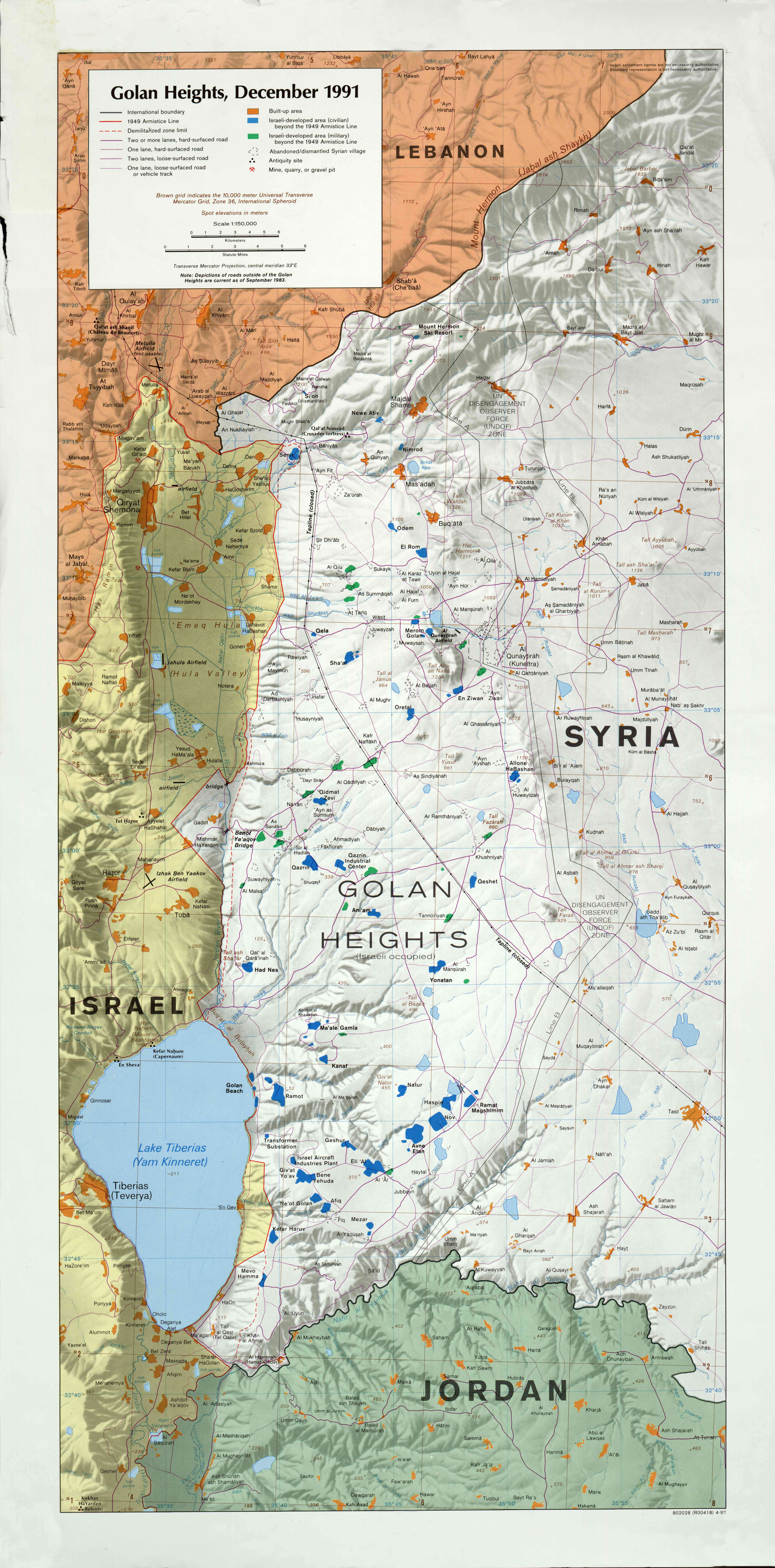
- Golan Heights, December 1991 1:150,000 1992 (4.5MB)
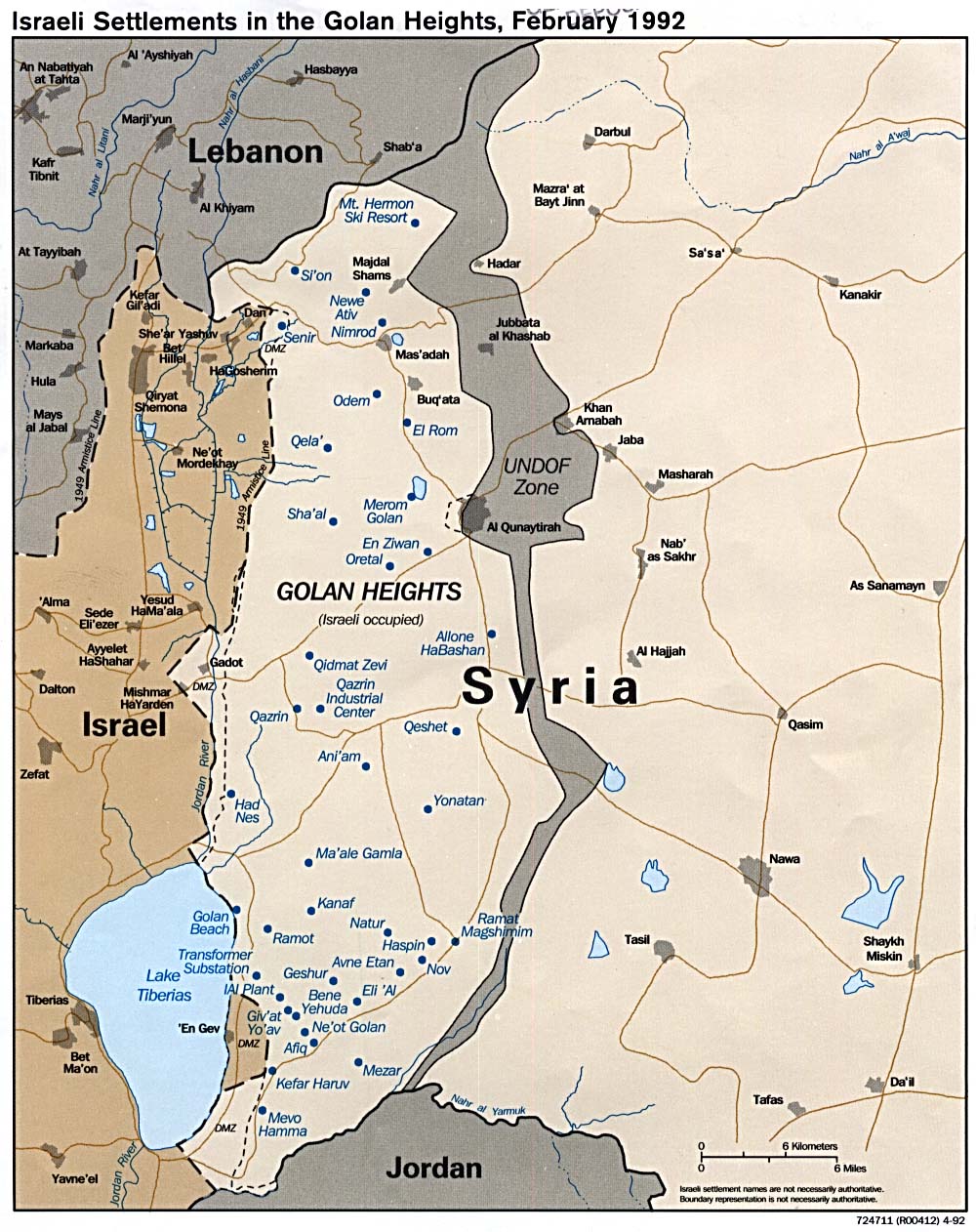
- Israeli Settlements in the Golan Heights 1992 (241K)
- Israeli Settlements in the Golan Heights (Shaded Relief) 1989 (211K)
Syria Maps on Other Web Sites 2020:
- August 23 - Military Situation (Southfront.org)
- June 23-24 - Inter-factional conflict in Idlib (@syria_map)
- May 31 - Syria Military Situation (Syria Intelligence)
- May 1 - Idlib Region Military Situation (in French) (Syria Intelligence)
- March 10 - Syria Zones of Control (AFP)
- March 10 - Security Corridor Along the M-4 Motorway, Idlib (Syria Intelligence)
- February 5 - Military Situation in Aleppo and Idlib Governorates (@PetoLucem)
- January 29 - Military Situation in Aleppo and Idlib Governorates (@PetoLucem)
- January 28 - Military Situation in Hama and Idlib Governorates (@PetoLucem)
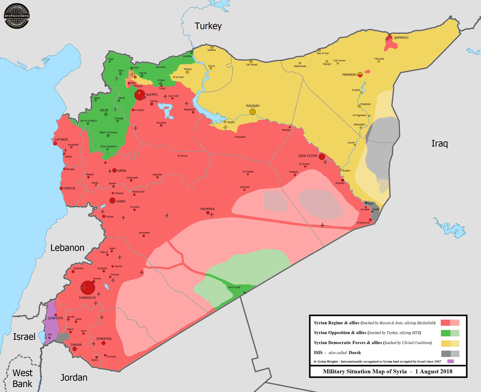
- January 26 - Military Situation Map of Syria (Archicivilians)
- December 9 - Military Situation in Syria (Southfront.org)
- October 27 - Where the Raid on al-Baghdadi Took Place in Syria (New York Times)
- October 23 - Map Comparison: Turkish-US Safe Zone vs. Turkish-Russian Safe Zone In Northeastern Syria (SouthFront.org)
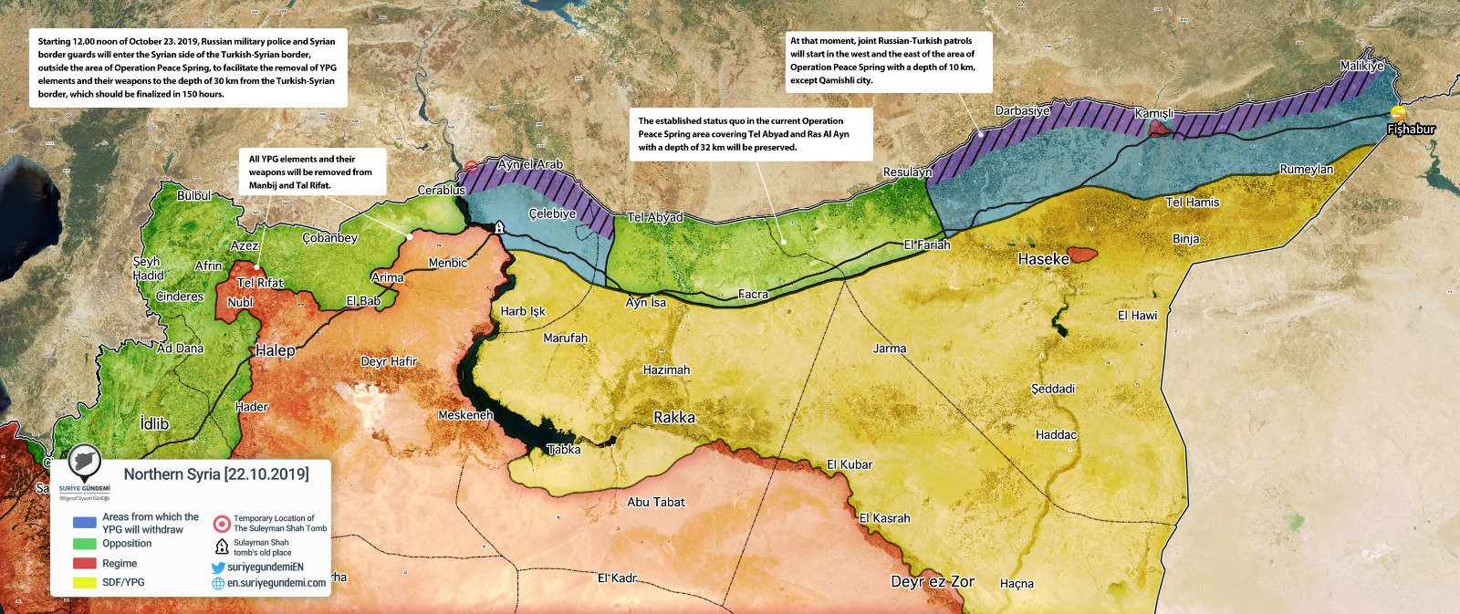
- October 22 - Northern Syria (en.suriyegundemi.com)
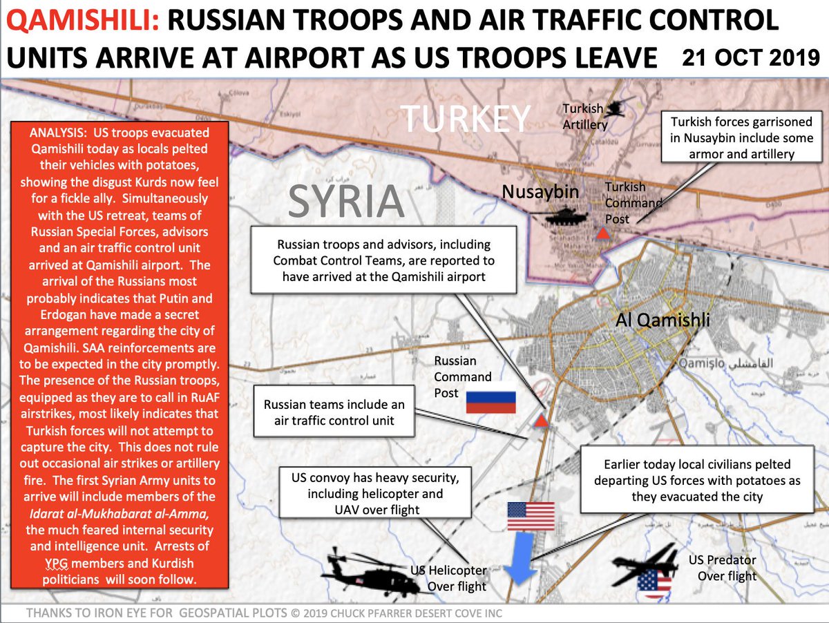
- October 21 - Al Qamishli (Chuck Pfarrer Desert Cove)
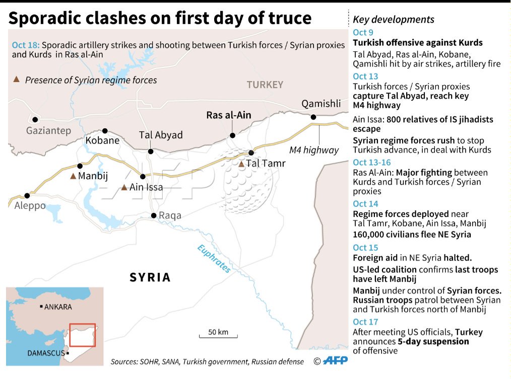
- October 19 - Sporadic Clashes on First Day of Truce (AFP)
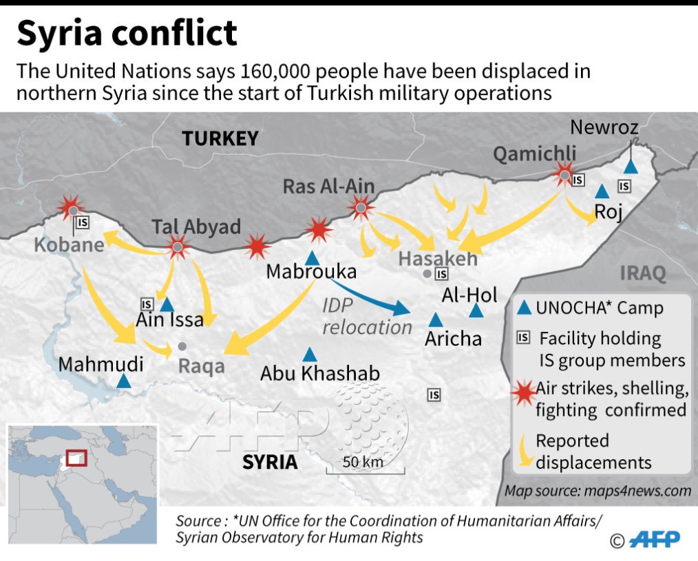
- October 15 - Syria Border Conflict (AFP)
- October 14 - Turkey's Syria Offensive Maps (BBC News)
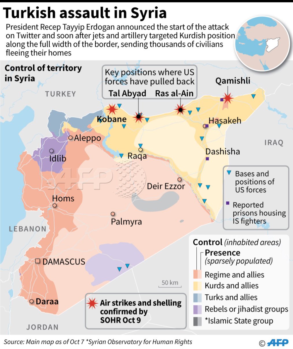
- October 9 - Turkish Assault in Syria (AFP)
- October 9 - Military Situation in Northeastern Syria (Southfront.org)
- October 9 - Military Situation in Syria (Southfront.org)
- September 8 - Military Situation in Northeastern Syria (Southfront.org)
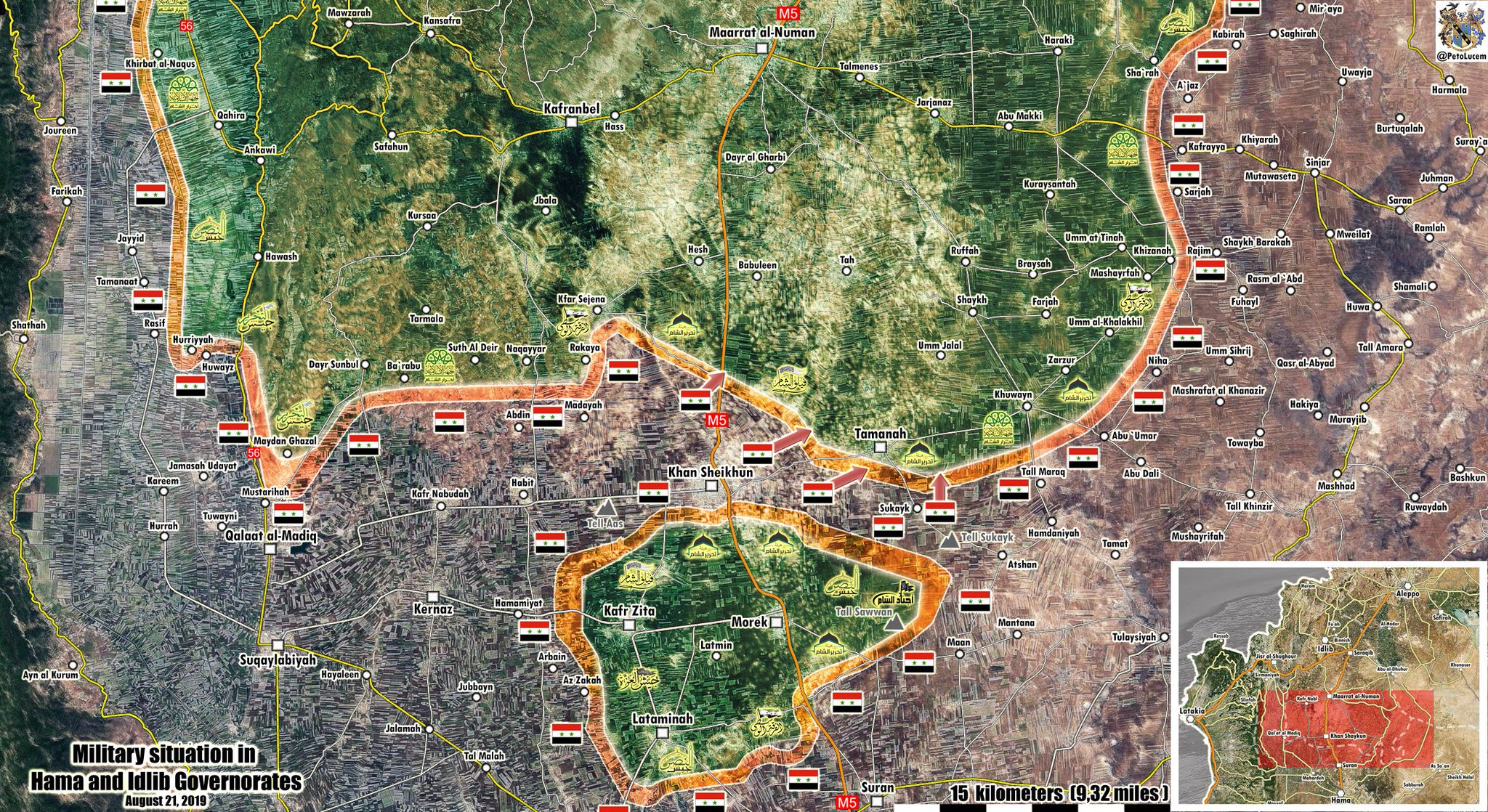
- August 21 - Military Situation in Hama and Idlib Governorates (@PetoLucem)
- August 1 - Syrian Army in Northern Hama (AMN)
- July 21 - Military Situation in Syria (Southfront.org)
- July 13 - Military Situation in Northwest Hama (AlMasdarNews)
- May 6 - Northern Hama Military Situation (Islamic World News)
- March - How Area Under IS Control Has Shrunk (BBC News)
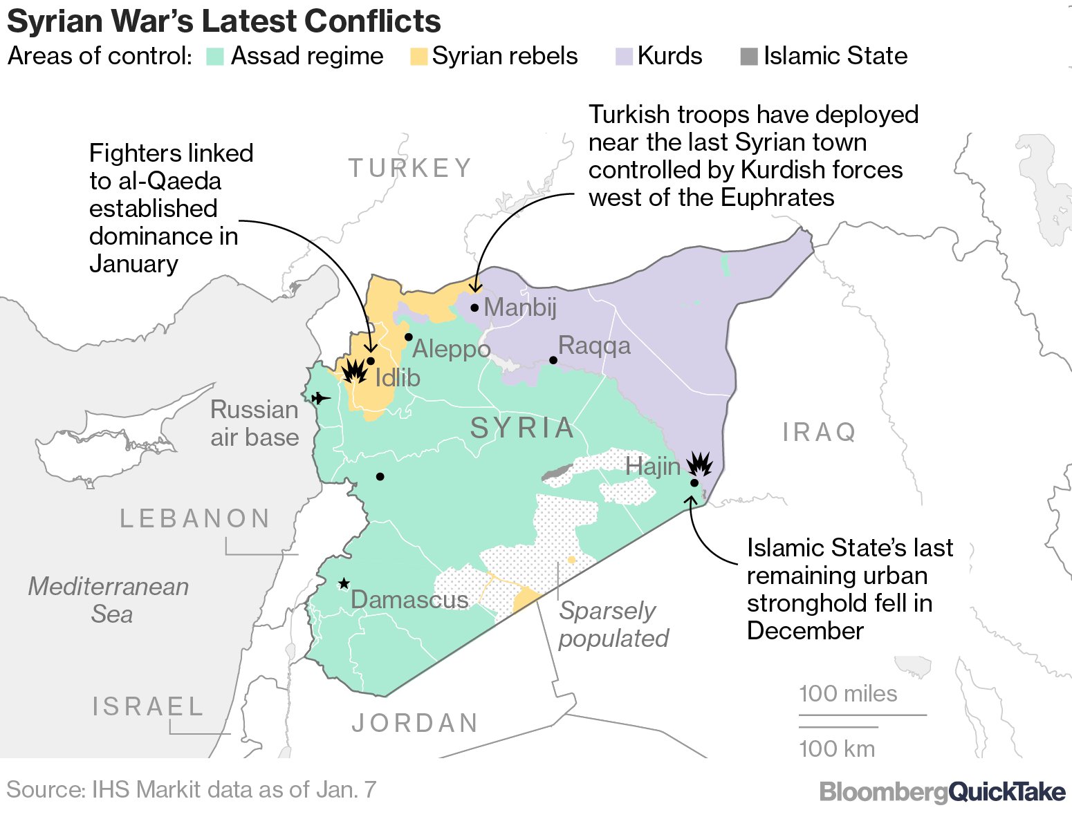
- January 7 - Syrian War's Latest Conflicts (Bloomberg)
- August 22 - Situation in Northwest Syria (@PetoLucem)
- August 1 - Syria Situation (Archicivilians)
- July 19 - Military Situation in Quneitra Governorate (@PetoLucem)
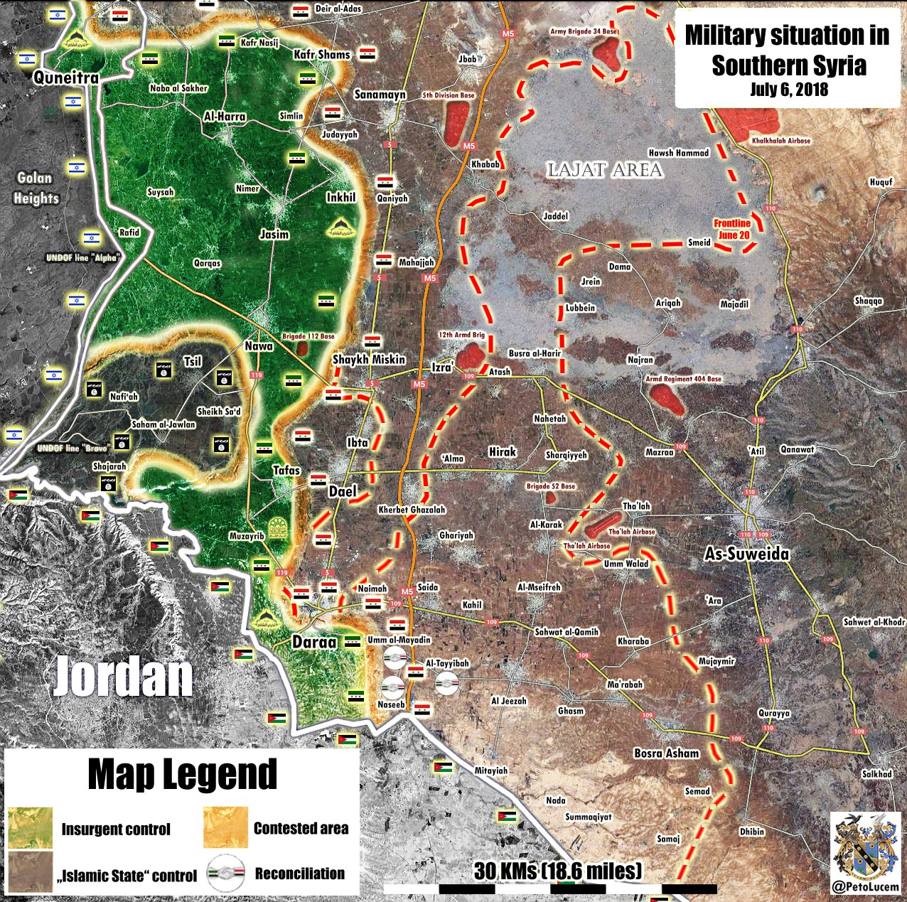
- July 6 - Government Victory in Daraa Province (@PetoLucem)
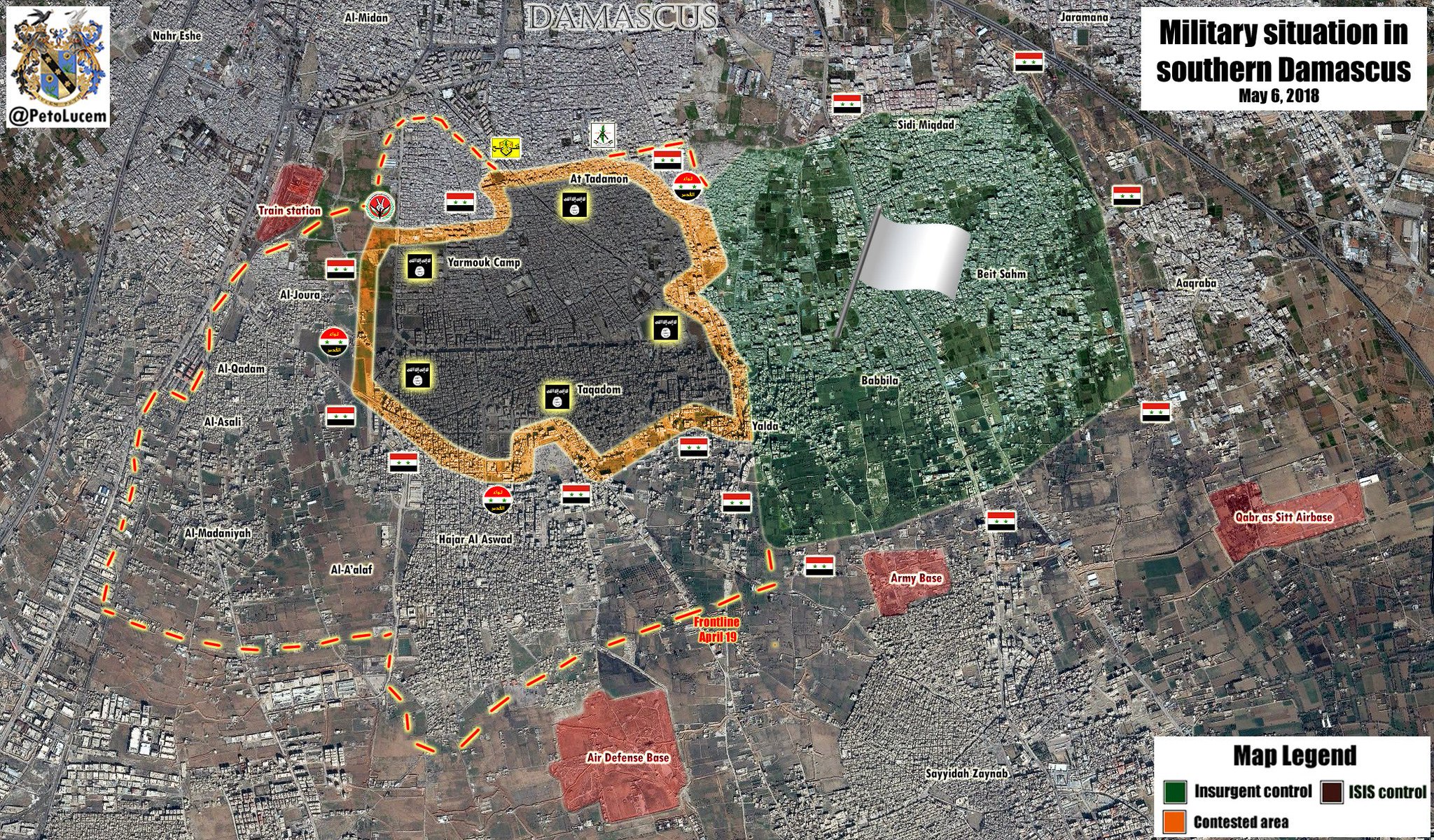
- May 6 - Military Situation in Southern Damascus (@PetoLucem)
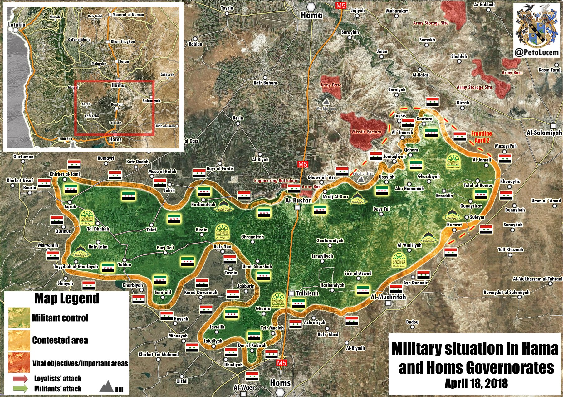
- April 18 - Military Situation in Hama and Homs Governorates (@PetoLucem)
- April 15 - Military Situation in Southern Damascus (@PetoLucem)
- April 15 - Syrian Sites Targeted (Washington Post)
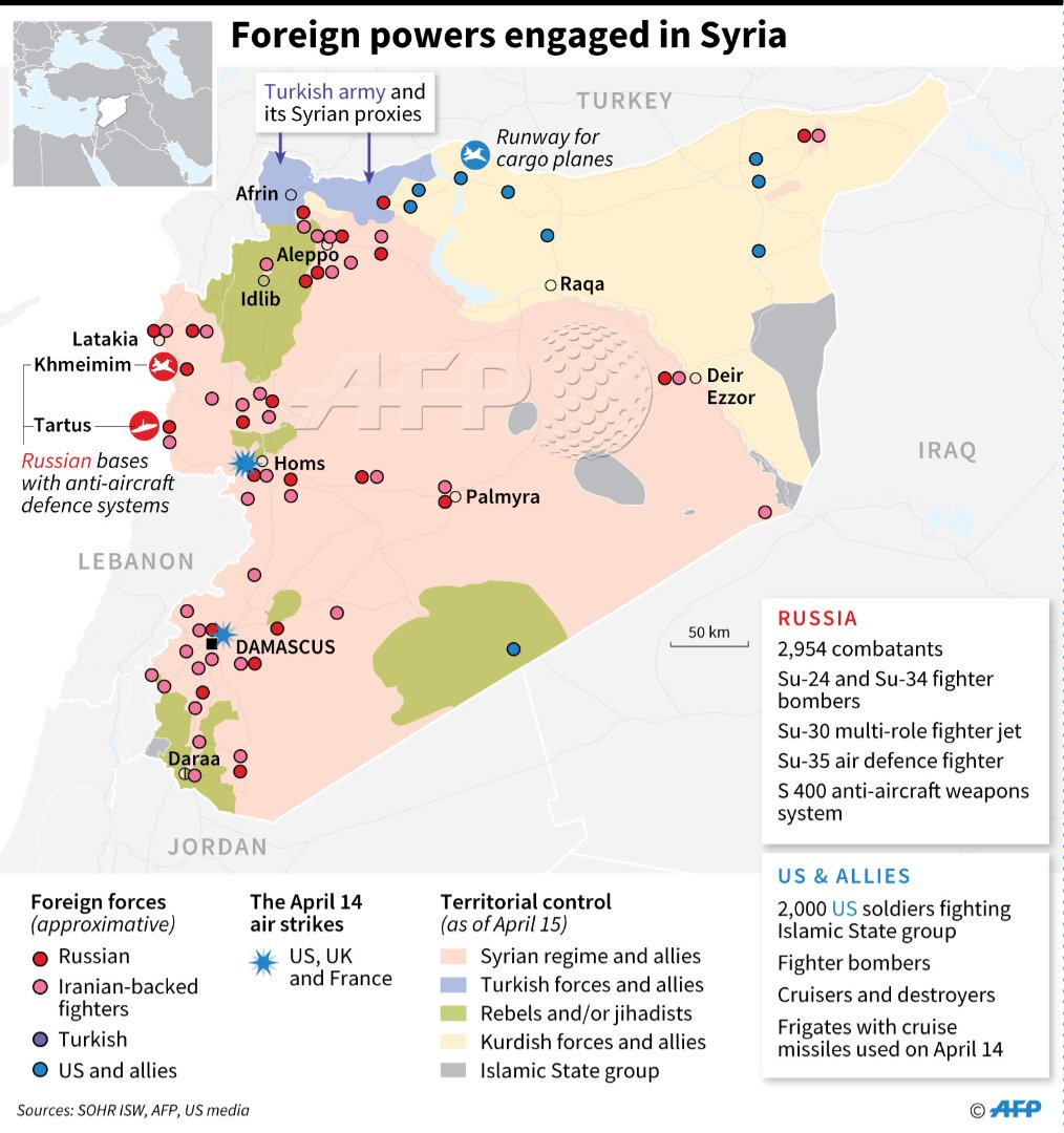
- April 15 - Foreign Powers Engaged in Syria (AFP)
- April 14 - Syria - Targeted Sites (New York Times)
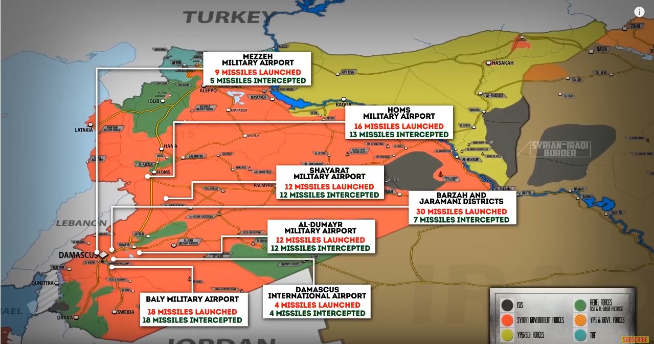
- April 14 - Syria - U.S. Missile Strikes in Syria (U.S. Department of Defense)
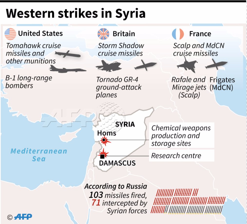
- April 14 - Syria - Western Strikes in Syria (AFP)
- April 14 - U.S., U.K., France Conduct Missile Strike On Syria (PetoLucem)
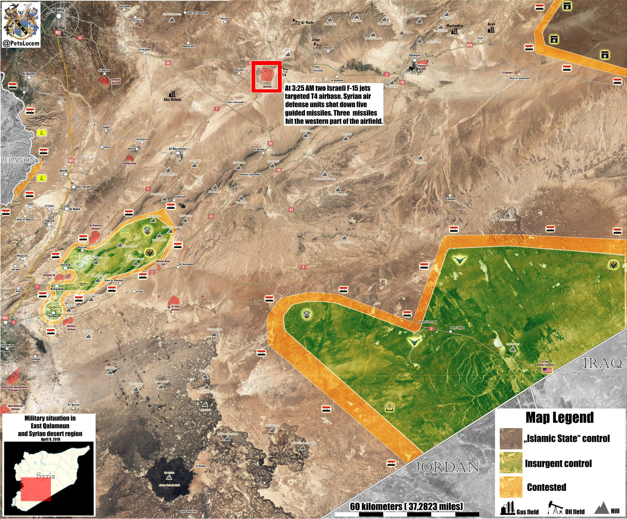
- April 9 - Syria - T-4 Air Base / Military Situation in East Qalamoun and Syrian Desert Region (PetoLucem)
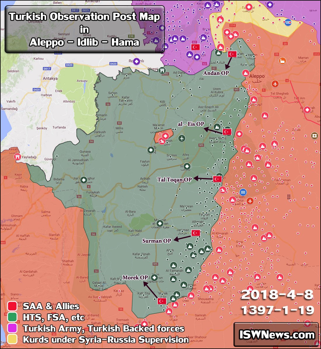
- April 8 - Syria - Turkish Observation Post Map (ISWNews.com)
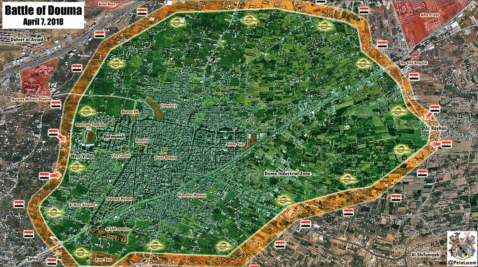
- April 7 - Syria - Battle of Douma (PetoLucem)
- March 19 - Syria - Afrin and Northern Syria (@PetoLucem)
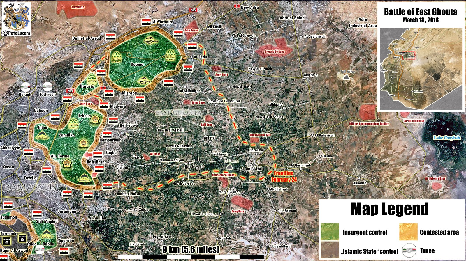
- March 18 - Syria - Battle of East Ghouta (@PetoLucem)
- March 13 - Syria - Ghouta Enclave (Washington Post)
- March 5 - Syria - Eastern Ghouta (BBC News)
- July 19 - Military Situation in Quneitra Governorate (@PetoLucem)
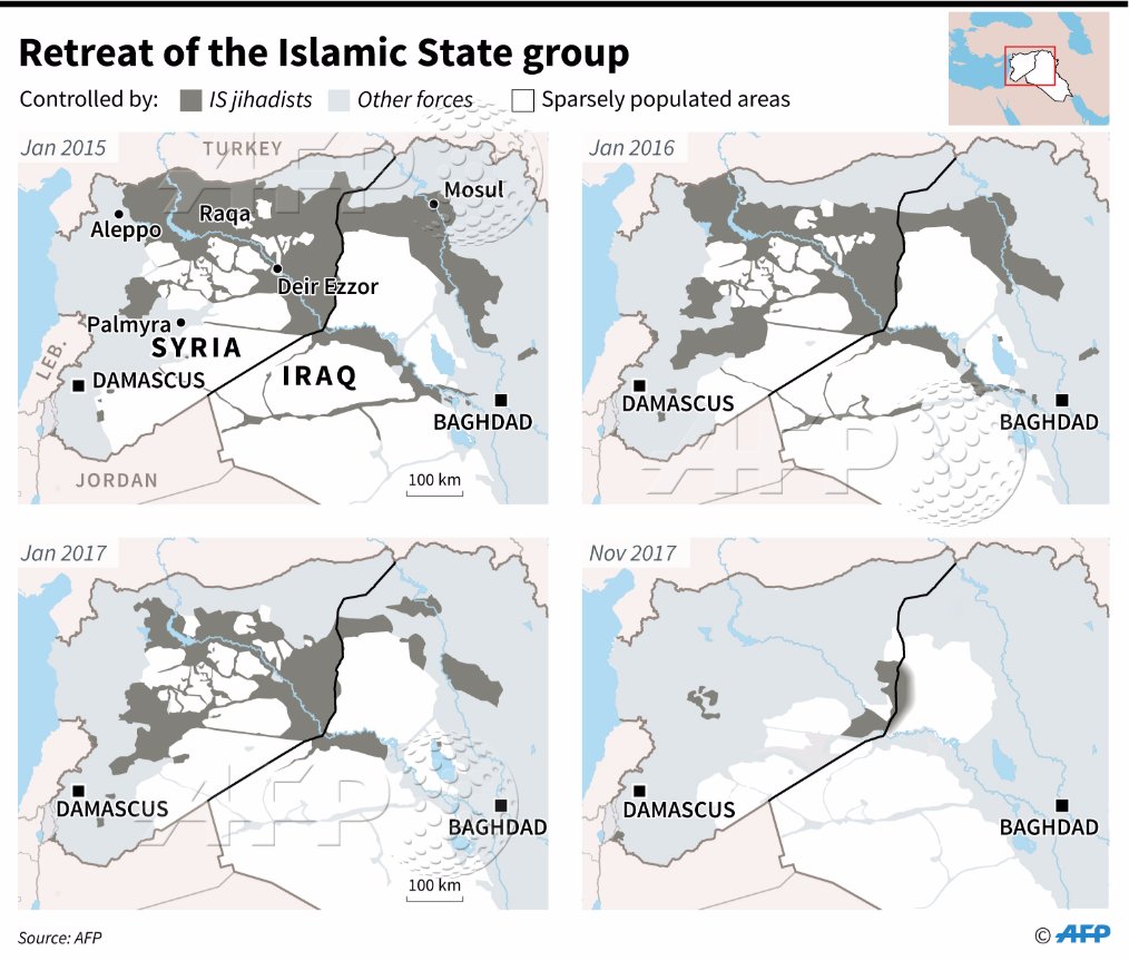
- November 17 - Retreat of the Islamic State Group, Jan. 2015 - Nov. 2017 (AFP)
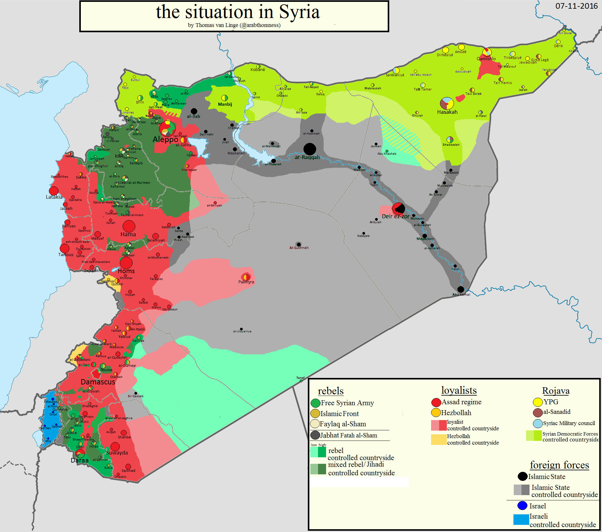
- November 1 - Military Situation in Syria-Iraq (@PetoLucem)
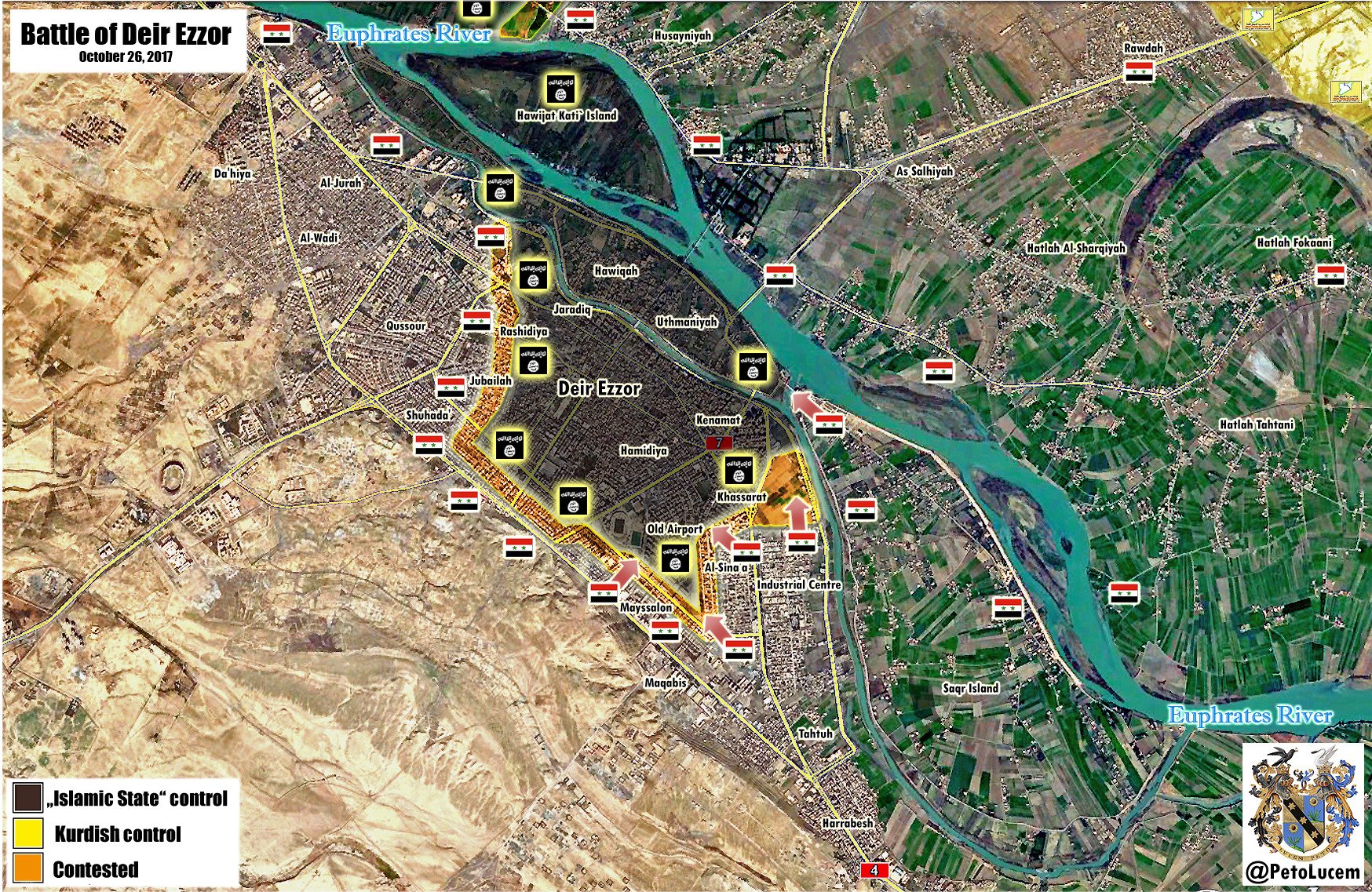
- October 26 - Battle of Deir Ezzor (@PetoLucem)
- October 18 - Military Situation in Eastern Syria (@PetoLucem)
- September 12 - Raqqa Satellite Map (Lucio Cienfuegos)
- September 12 - Raqqa Street Map (Lucio Cienfuegos)
- September 11 - Raqqa Animated GIF [July 17 - September 11, 2017] (Lucio Cienfuegos)
- September 10 - Deir Ezzor (AFP)
- September 5 - Eastern Syria Situation (@PetoLucem)
- September 3 - Raqqa Situation (SyriacMilitaryMFS)
- August 11 - Map of the Battle of Raqqa (@gagaristan)
- August 6 - Syria: Regime Troops Advance Towards Raqa (AFP)
- July 27 - Raqqa Situation (Nathan Ruser)
- July 27 - Raqqa Situation (Syriac Military Council)
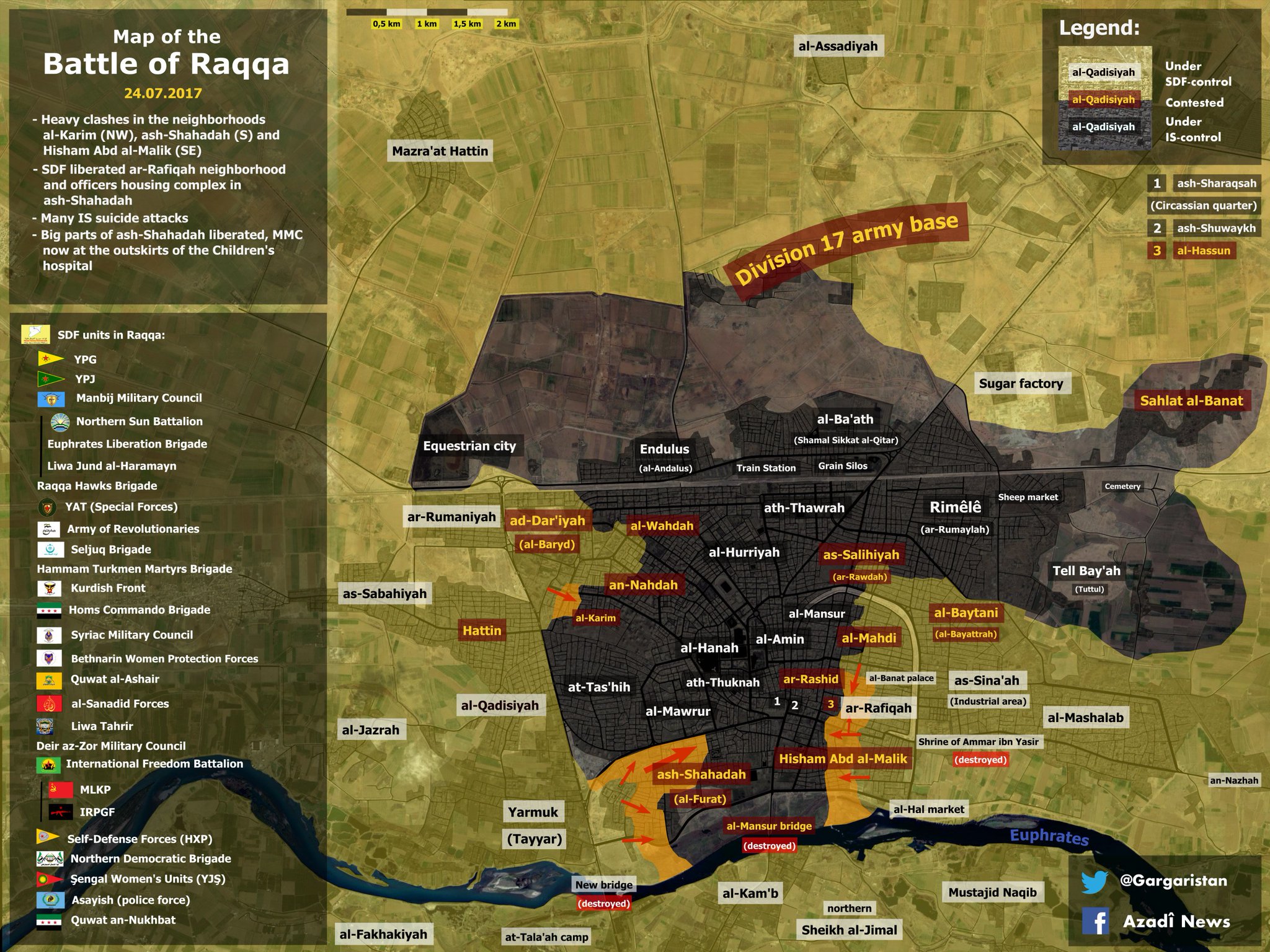
- July 27 - Military Situation in Eastern Syria (@PetoLucem)
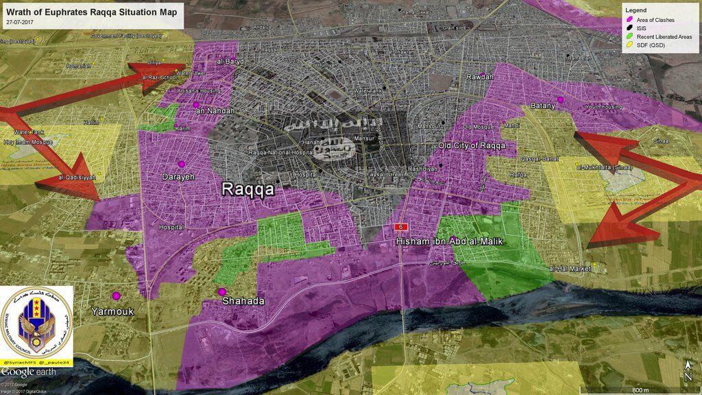
- July 24 - Battle of Raqqa (@Gagaristan)
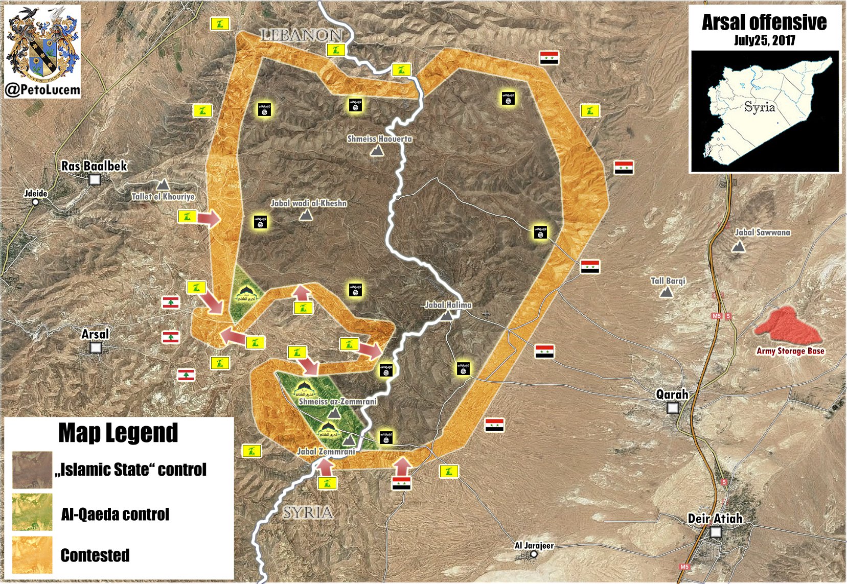
- July 25 - Arsal Offensive (@PetoLucem)
- July 16 - Isis January 15 and Today (Washington Post)
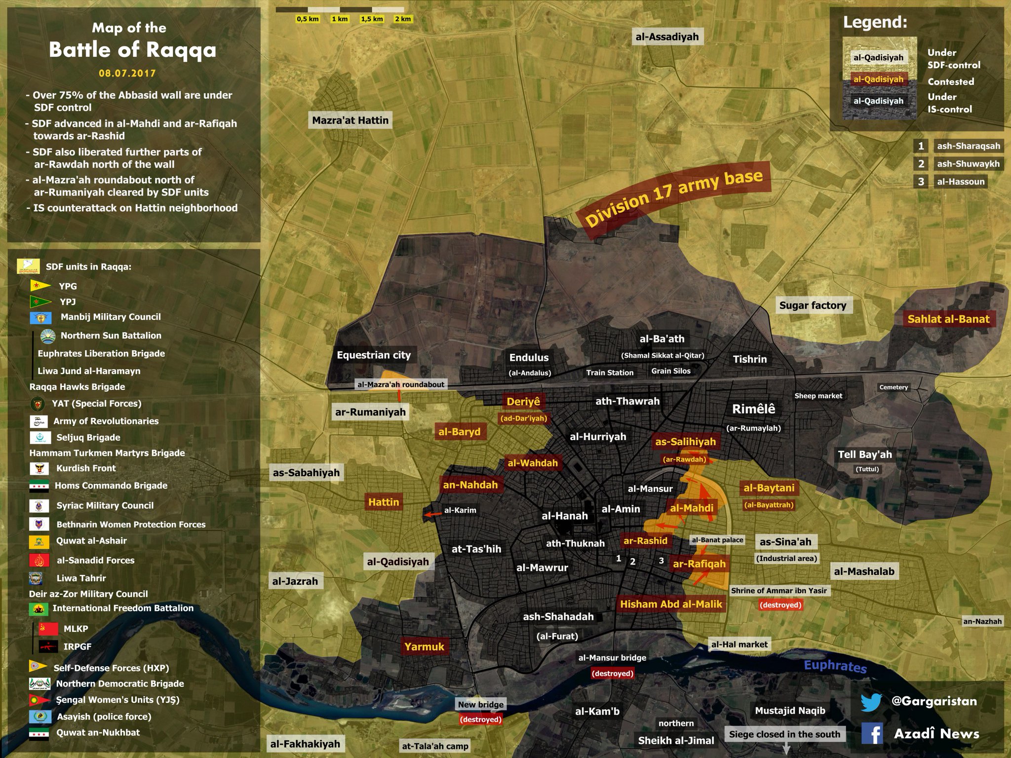
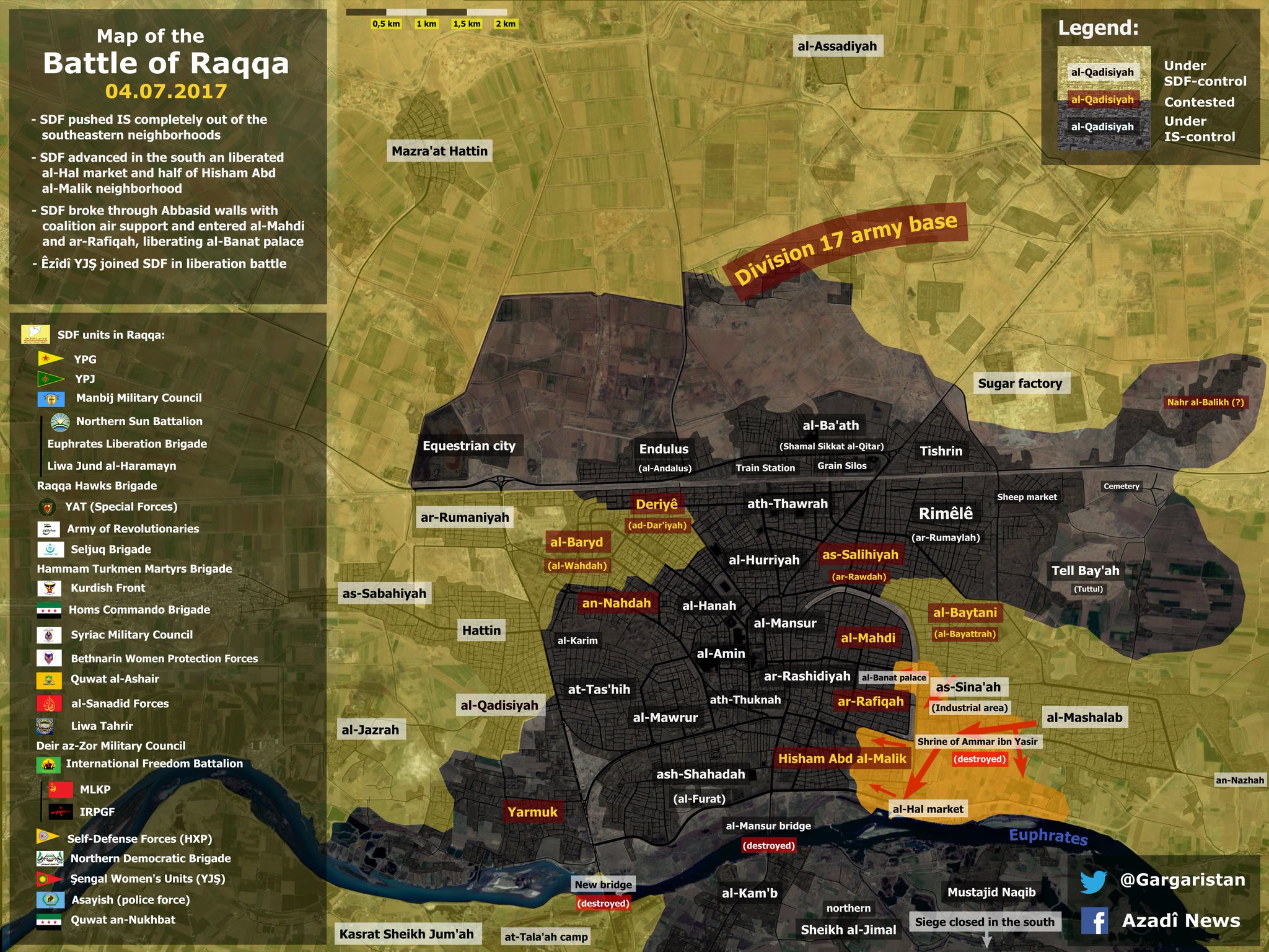
- July 8 - Battle of Raqqa (Gargaristan)
- July 4 - Battle of Raqqa (@Gargaristan)
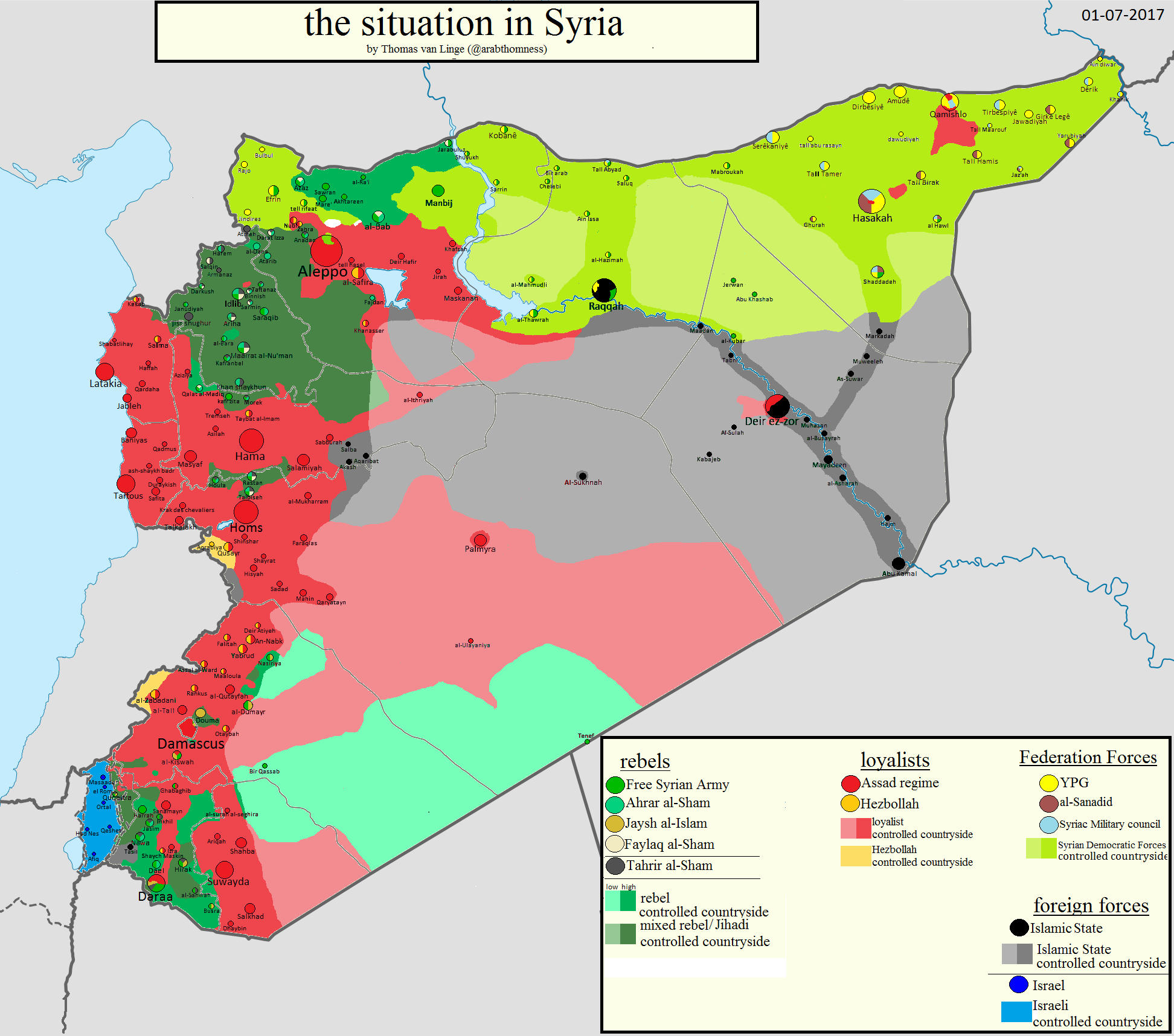
- July 1 - The Situation in Syria (Thomas van Linge)
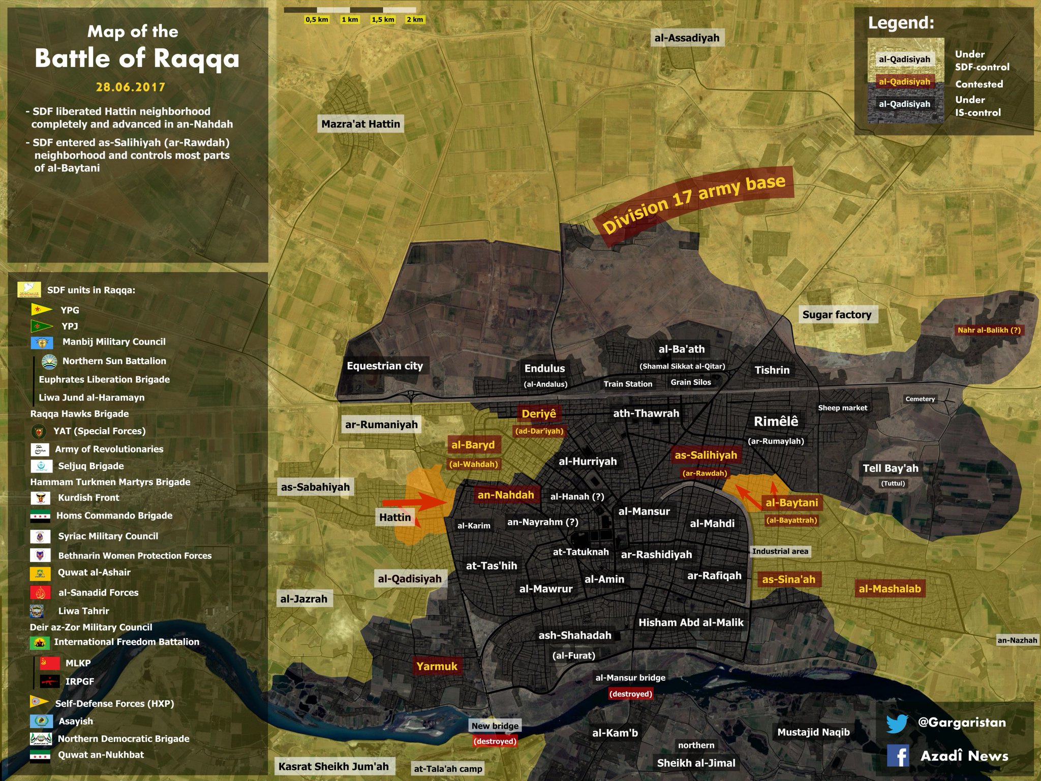
- June 28 - Battle of Raqqa (@Gargaristan)
- June 22 - Military Situation on the Syria-Iraqi Border (Peto Lucem)
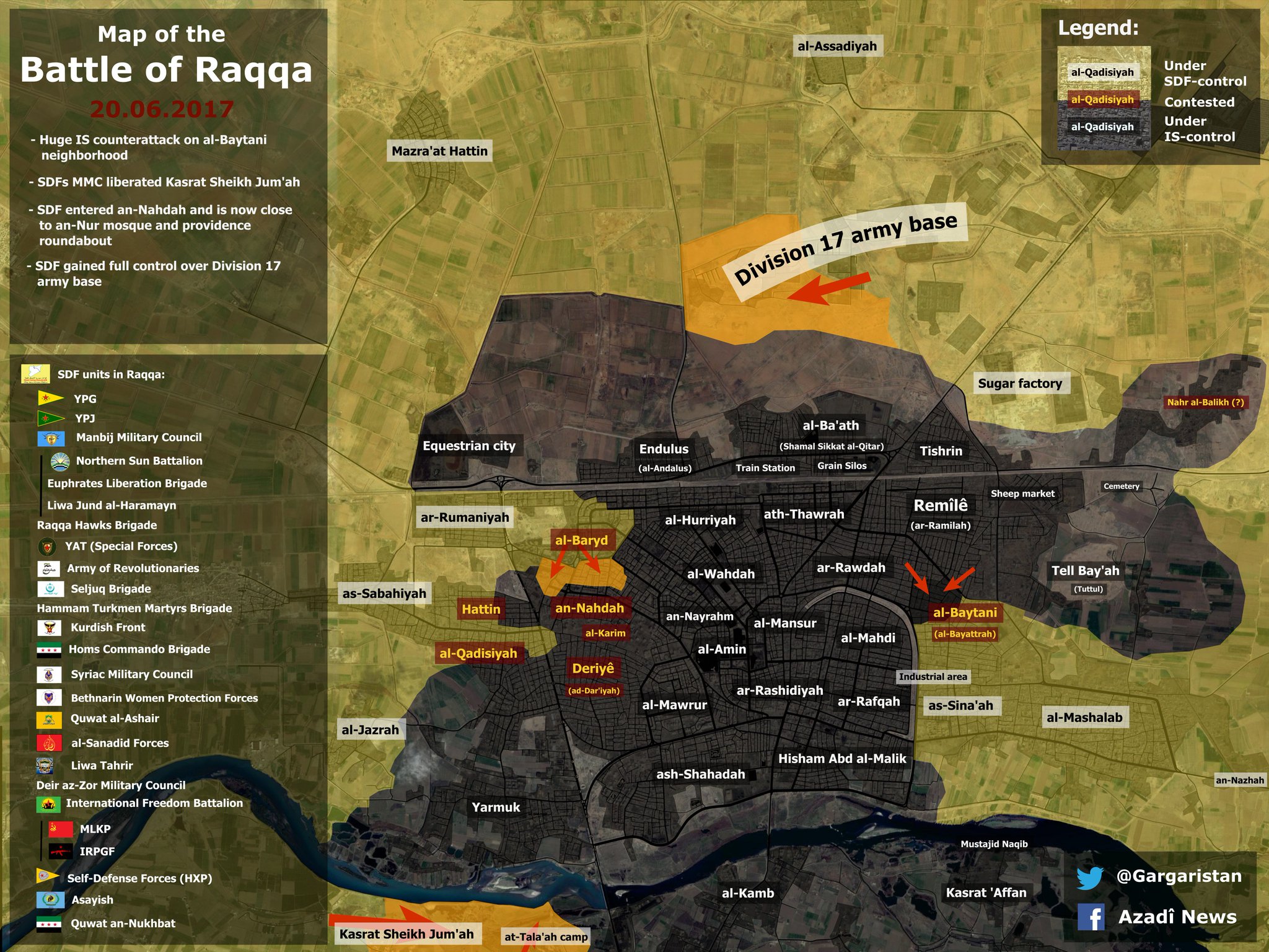
- June 20 - Battle of Raqqa (@gagaristan)
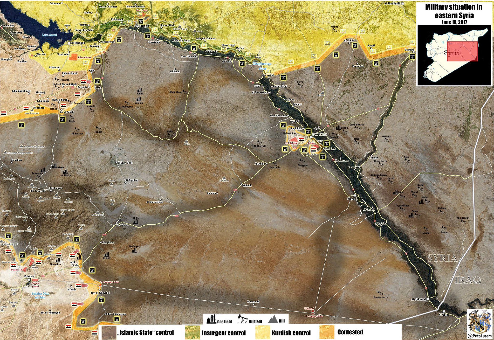
- June 18 - Military Situation in Eastern Syria (Peto Lucem)
- June 18 - Raqqa Street Map Showing the Raqqa Front (Lucio Cienfuegos)
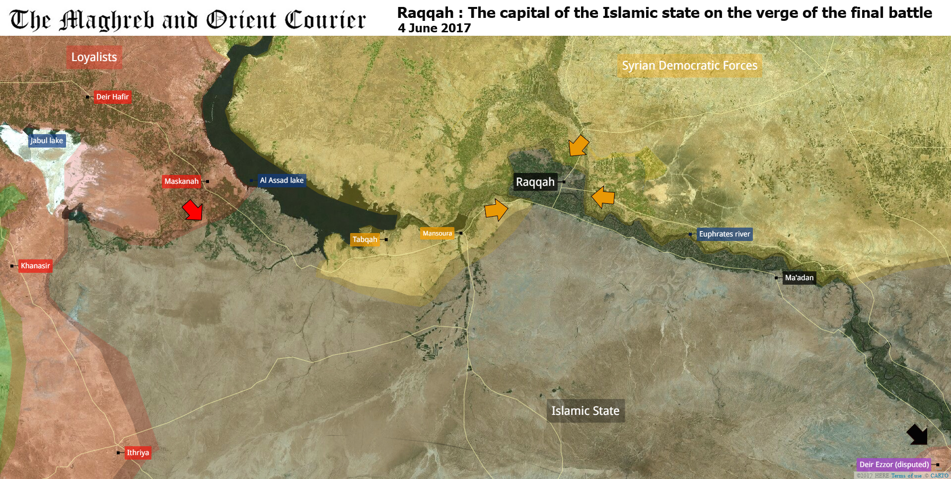
- June 4 - Raqqah - On the Verge of the Final Battle (Maghreb and Orient Courier)
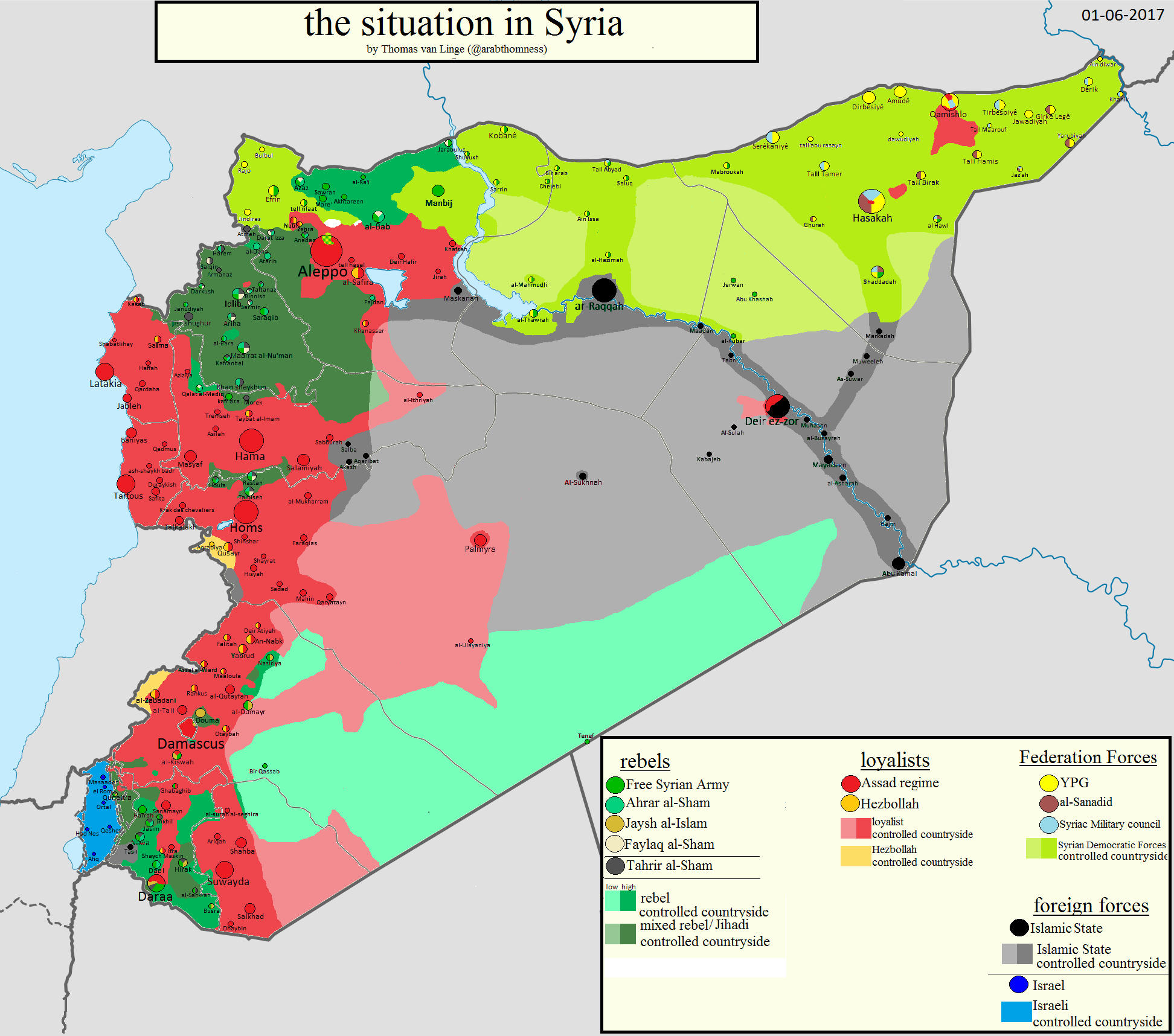
- June 1 - Situtation in Syria (Thomas van Linge)
- May 18 - Syria from Space (BBC News)
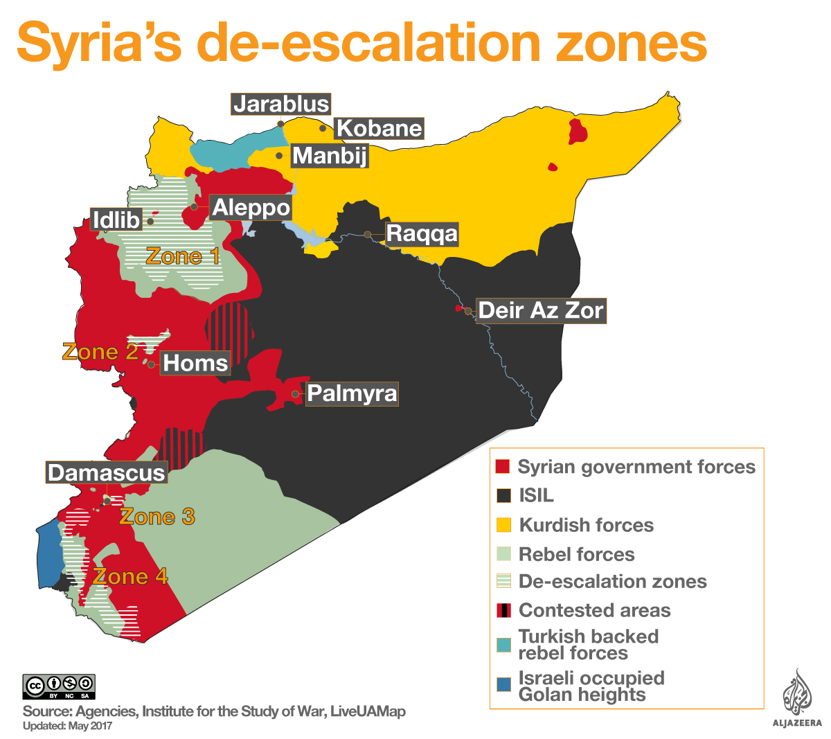
- May 8 - Syria's de-esclation Zones (Al Jazeera)
- May 5 - De-escalation zones in Syria (MPC Journal)
- May 4 - SDF in Control of Tabqa (Step News Agency)
- May 1 - Battle of Tabqa (@leshker_)
- April 9 - Syria Interactive Conflict Map (Agathocle de Syracuse)
- April 7 - Situation in Syria (Thomas van Linge)
- April 7 - American Military Attack on Syria (New York Times)
- April 7 - Syria Conflict (AFP)
- April 7 - U.S. Launches Missiles at Syrian Airfield (Washington Post)
- April 7 - Shayrat Air Base, Homs Governorate - Satellite Image (Google Maps)
- April 6 - South Syria Situation (Islamic World News)
- April 6 - Raqqa Area (PetoLucem)
- March 30 - Situation & Coalition East of Damascus (@BosnjoBoy)
- March 27 - Tabqa/Raqqa Area (BBC News)
- March 20 - The Situation in Syria (Thomas van Linge)
- March 7 - The Situation in Syria (Thomas van Linge)
- February 12 - Battle of Daraa (Peto Lucem)
- February 8 - Northern Syria (LCarabinier)
- February 5 - The Situation in Syria (Thomas van Linge)
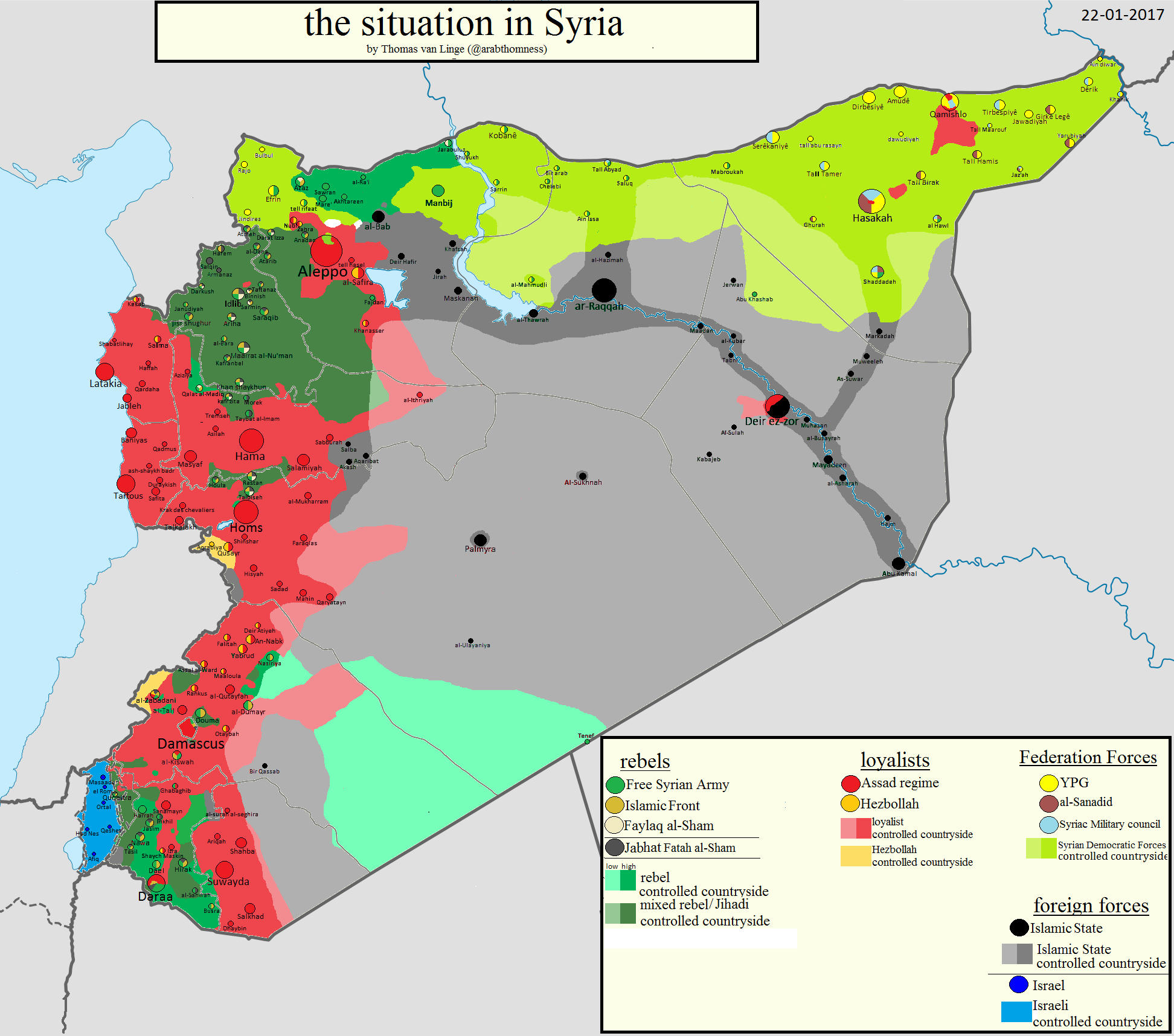
- January 22 - The Situation in Syria (Thomas van Linge)
- January 16 - Military Situation in Deir Ezzor Governorate (Peto Lucem)
- January 8 - Syrian War Detailed Clickable Map (Wikipedia)
- January 8 - The Situation in Syria (Thomas van Linge)
2016:- December 29 - The State of the War in Syria (New York Times)
- December - Aleppo Situation (BBC News)
- December 5 - Aleppo Situation (Vasto)
- December 4 - The Situation in Syria (Thomas van Linge)
- November 29 - Aleppo Situation (Warsmonitoring)
- November 28 - Aleppo Situation (Vasto)
- November 28 - Aleppo Ground Elevation and Situation (Warsmonitoring)
- November 7 - The Situation in Syria (Thomas van Linge)
- October 24 - Islamic State Group in Syria and Iraq (AFP)
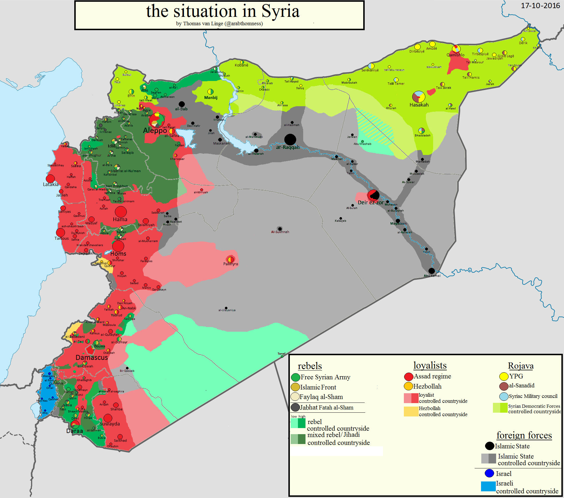
- October 17 - The Situation in Syria (Thomas van Linge)
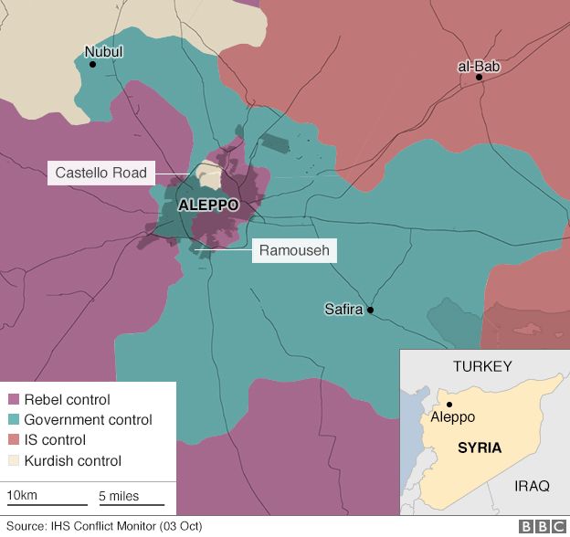
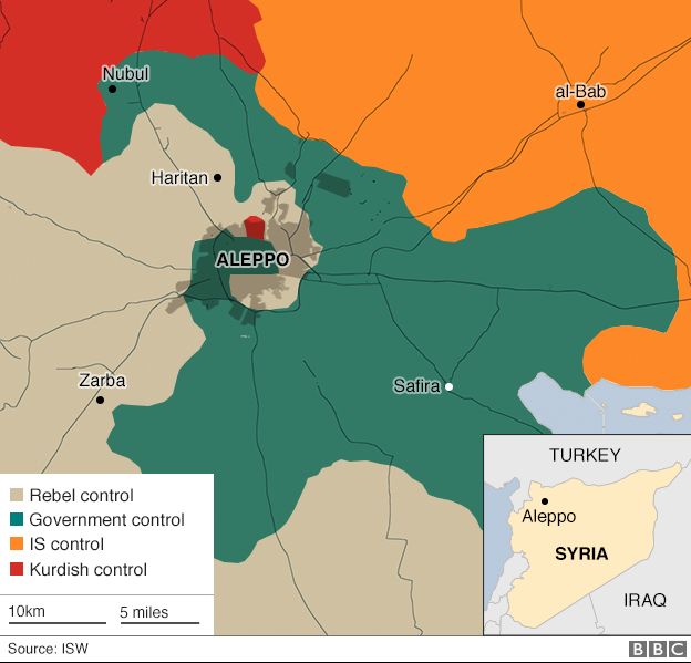
- October 3 - Aleppo (BBC News)
- October 3 - The Situation in Syria (Thomas van Linge)
- September 30 - Syria - Situation Before Russian Intervention and Now (AFP)
- September 30 - Aleppo [September 30] (AFP)
- September 1 - The Situation in Syria (Thomas van Linge)
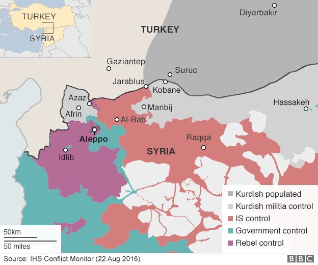
- August 22 - Northern Syria Control (BBC News)
- August 16 - The Situation in Syria (Thomas van Linge)
- August 1 - The Situation in Syria (Thomas van Linge)
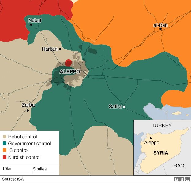
- July 28 - Aleppo (BBC News)
- July 3 - The Situation in Syria (Thomas van Linge)
- July 3 - Isis Has Lost Many of the Key Places it Once Controlled (New York Times)
- June 1 - The Situation in Syria (Thomas van Linge)
- May 16 - The Situation in Syria (Thomas van Linge)
- May 3 - The Situation in Syria (Thomas van Linge)
- April 3 - The Situation in Syria (Thomas van Linge)
- April/May - Aleppo Situation (BBC News)
- March 13 - The Situation in Syria (Thomas van Linge)
- February 16 - The Situation in Syria (Thomas van Linge)
- February 16 - How Russian Bombing is Changing Syria's War in 3 Maps (Vox)
- February 14 - Syrian Army Captures Tayyibah Village in Eastern Aleppo (AMN)
- February 11 - How the Assad Regime is Winning in Syria (Washington Post)
- February 5 - The Situation in Syria (Thomas van Linge)
- February 2 - The Battle for Aleppo (South Front)
- January 22 - Syria Conflict: U.S. Expanding Airstrip in Kurdish North (BBC News)
- January 18 - Syria - The Situation in Syria (Thomas van Linge)
- January 11 - Syria Siege Towns (AFP)
- January 4 - The Situation in Iraq (Thomas van Linge/IUCA)
2015:- Syria - Atlas [2015] (Austria Federal Ministry of the Interior) [PDF]
- Syria - Situation Maps [regular updates] (Institute for the Study of War)
- Syria - War Maps [regular updates] (Archicivilians)
- Syria - War Maps [regular updates] (IUCA)
- December 15 - The Situation in Syria (Thomas van Linge)
- December 7 - The Situation in Syria (Thomas van Linge)
- November 25 - Russian Jet Shot Down by Turkey (BBC News)
- November 25 - Russian Jet Shot Down by Turkey (AFP)
- November 25 - Russian Jet Shot Down by Turkey (The Telegraph)
- November 25 - Russian Jet Shot Down by Turkey (New York Times)
- November 21- Inside Raqqa: The Capital of Isis (New York Times)
- Syria - Hitting Isis in Raqqa After the Paris Attacks [November 20] (New York Times)
- November 19 - Russian Airstrikes in Syria: November 9 - 19 (ISW)
- November 18 - Reported Russian Air and Cruise Missile Routes (ISW)
- November 16 - The Situation in Syria (Thomas van Linge)
- November 2 - Syria Interactive Map (deSyracuse)
- November 1 - The Situation in Syria (Thomas van Linge)
- November 1 - The Situation in Syria (Thomas van Linge)
- November 1 - Russian Airstrikes in Syria: October 23 - November 1 (ISW)
- October 21 - USA - Syrian Refugees Map (New York Times)
- October 18 - Syria - Russian Airstrikes in Syria: September 30-October 18 (ISW)
- October 17 - Aleppo Offensive (Wikimedia)
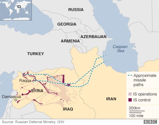
- October 7 - Syria - Russian Missiles Hit IS in Syria from Caspian Sea (BBC News)
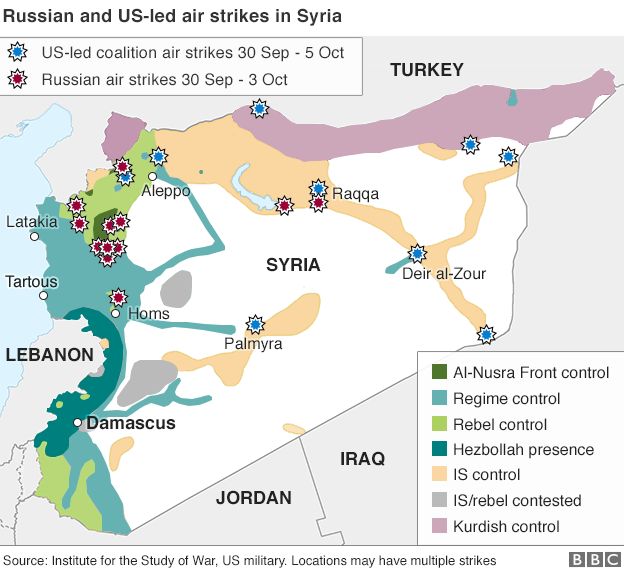
- October 5 - Syria - Russian and U.S. Air Strikes 30 September (BBC News)
- October 4 - The Situation in Syria (Thomas van Linge)
- October 1 - Russian Airstrikes (BBC News)
- October 1 - Syria - Forces in the Zone [October 1] (Daily Mail)
- October 1 - Syria and Iraq - A Comparision of Territorial Sizes with Europe (L Carabiner)
- September 30 - Who Has Gained Ground in Syria Since Russia Began Its Airstrikes (New York Times)
- September 16 - The Situation in Syria (Thomas van Linge)
- September 2 - The Situation in Syria (Thomas van Linge)
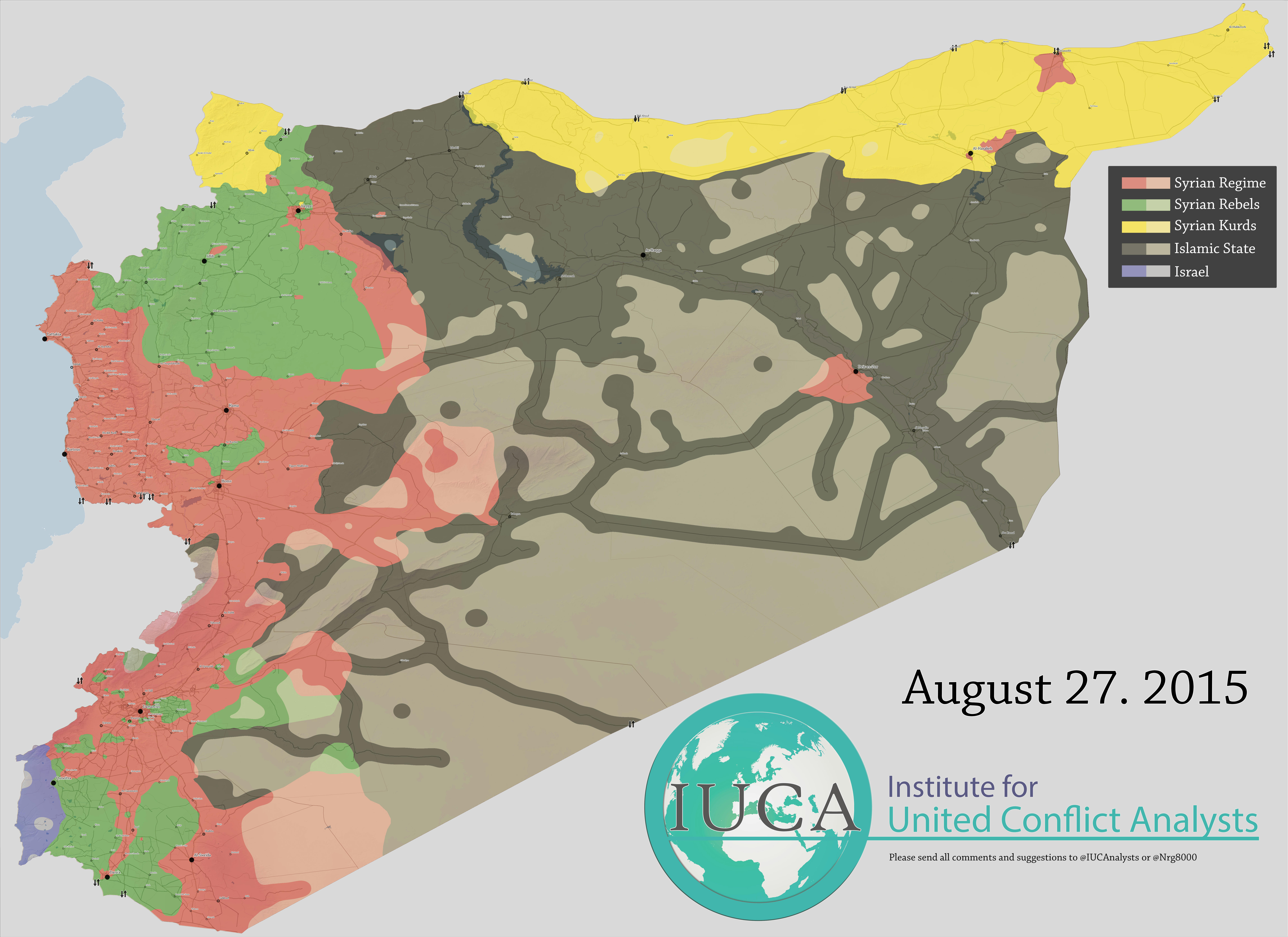
- August 27 - Syria - Situation (IUCA)
- August 18 - The Situation in Syria (Thomas van Linge)
- August 12 - Syria - Situation (IUCA)
- August 1 - The Situation in Syria (Thomas van Linge)
- July 16 - The Situation in Syria (Thomas van Linge)
- July 1 - The Situation in Syria (Thomas van Linge)
- June 15 - The Situation in Syria (Thomas van Linge)
- June 5 - The Situation in Syria (Thomas van Linge)
- June 1 - Syria Areas of Control (Agathocle de Syracuse)
- [April 2011 - June 2015] Syrians in Neighboring Countries and Europe (BBC News)
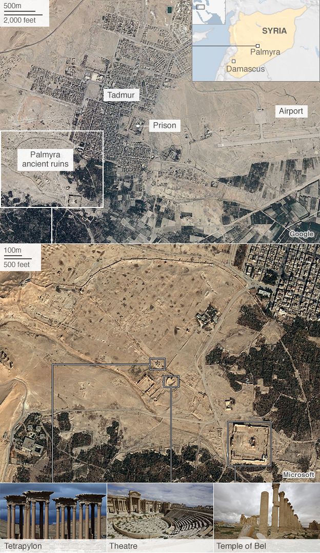
- May 22 - Palmyra (BBC News)
- May 22 - Palmyra (Wall Street Journal)
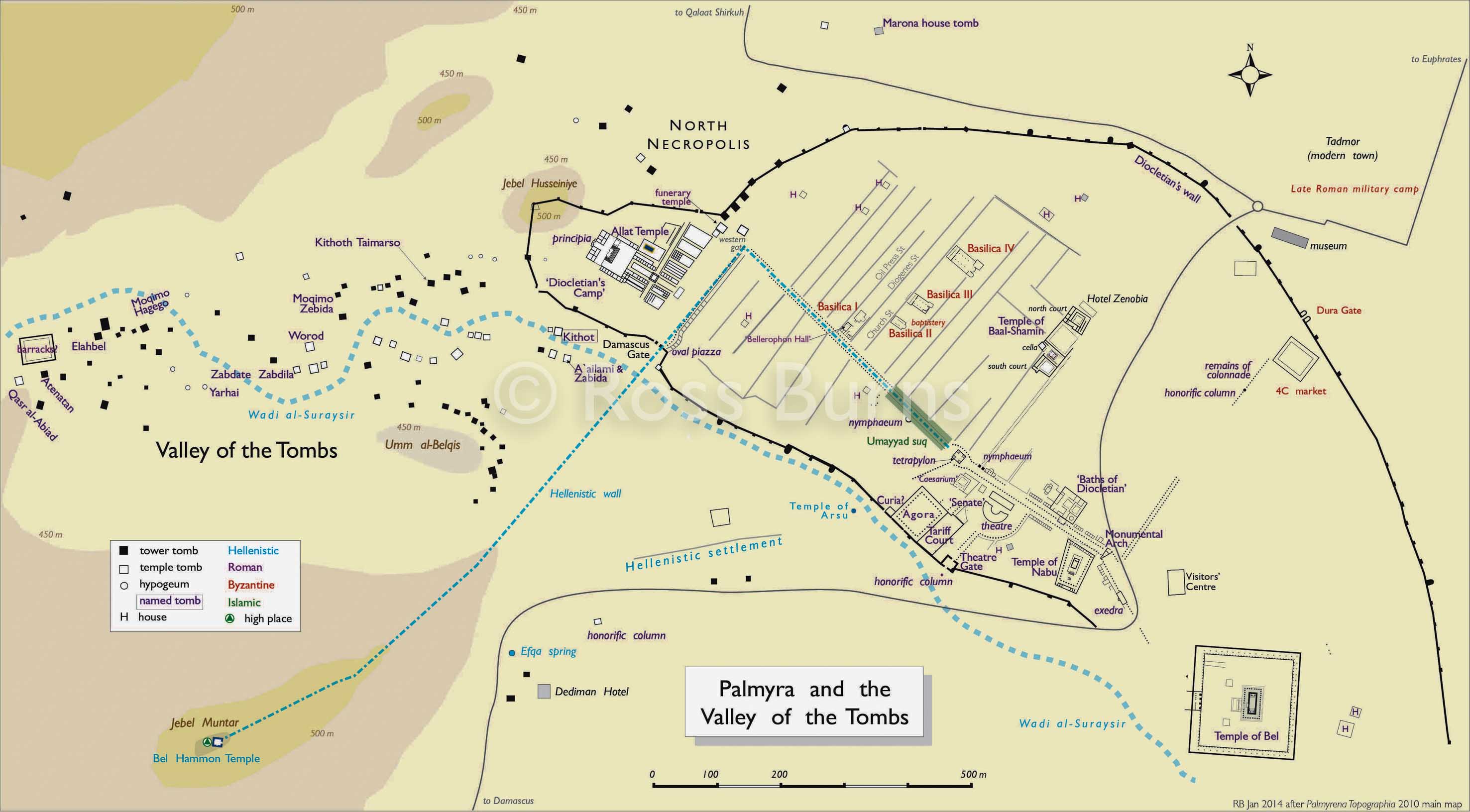
- May 22 - Palmyra and the Valley of the Tombs (Monuments of Syria)
- May 15 - The Situation in Syria (Thomas van Linge)
- May 1 - The Situtation in Syria (Thomas van Linge)
- April 15 - The Situation in Syria (Thomas van Linge)
- April 1 - The Situation in Syria (Thomas van Linge)
- March 26 - Idlib City Military Situation (Archicivilians)
- March 24 - Idlib City Military Situation (Archicivilians)
- March 19 - Aleppo Situation (Archicivilians)
- March 16 - From Syria, an Atlas of a Country in Ruins (New York Times)
- March 15 - The Situation in Syria (Thomas van Linge)
- March 5 - Damascus Situation (Archicivilians)
- March 7 - Assyrian Villages on the Khabur River (L Carabinier)
- March 1 - The Situation in Syria (Thomas van Linge)
- February 15 - The Situation in Syria (Thomas van Linge)
- February 15 - The Situation in Syria (Thomas van Linge)
- January 15 - The Situation in Syria (Thomas van Linge)
- January 14 - Foreign Fighters Flow to Syria (Washington Post)
- January 7 - Aleppo Situation (Archicivilians)
- January 5 - Syria: Mapping the (BBC News)
- January 1 - The Situation in Syria (Thomas van Linge)
- January - Syria Situation (Archicivilians)
2014:- Syria and Iraq - Battle for Iraq and Syria in Maps (BBC News)
- December 15 - The Situation in Syria (Thomas van Linge)
- December 8 - Who Controls Air Bases in Syria (Twitter)
- December 1 - The Situation in Syria (Thomas van Linge)
- November 15 - The Situation in Syria (Thomas van Linge)
- November 11 - Syria: Mapping the (BBC News/Internet Archive)
- November 2 - Syrian Desert (Archicivilians)
- November 1 - The Situation in Syria (Thomas van Linge)
- October 20 - Battle for Kobane (BBC News)
- October - Foreign Fighters Flow to Syria (Washington Post)
- October 16 - The Situation in Syria (Thomas van Linge)
- October 14 - Foreign Fighters Flow to Syria (Washington Post)
- October 9 - Syria Region: Conflicts Without Borders (U.S. Department of State. Humanitarian Information Unit)
- October 7 - ISIS Forces Advance on Kobane (BBC News)
- October 5 - The Situation in Syria (Thomas van Linge)
- September 22 - Aleppo Battles (Thomas van Linge)
- September 14 - Syrian Civil War Detailed Map (Wikipedia)
- September - Tomb of Suleyman Shah, Turkish Enclave in Syria (Google Maps)
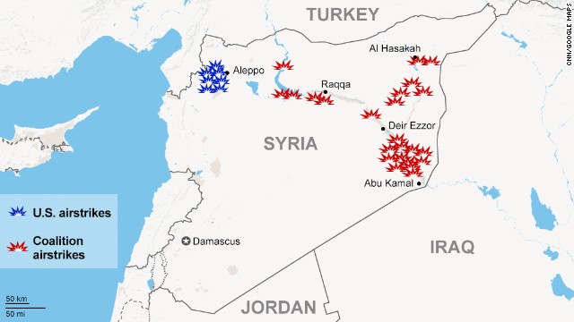
- September 23 - Airstrikes (CNN)
- September 15 - The Situation in Syria (Thomas van Linge)
- September 1 - The Situation in Syria (Thomas van Linge)
- August 14 - The Situation in Syria (Thomas van Linge)
- August 1 - The Situation in Syria (Thomas van Linge)
- August - Iraq and Syria - "New Map of the Middle East" (The Independent)
- July 7 - The Situation in Syria (Thomas van Linge)
- July 1 - The Situation in Syria (Thomas van Linge)
- June 18 - Battles of Southern Aleppo Province (archicivilians)
- June 15 - The Situation in Syria (Thomas van Linge)
- June 6 - The Situation in Syria (Thomas van Linge)
- May 15 - The Situation in Syria (Thomas van Linge)
- April 13 - The Situation in Syria (Thomas van Linge)
- March 13 - Syria: Mapping the (BBC News/Internet Archive)
- March 13 - The Situation in Syria (Thomas van Linge)
- February 12 - The Situation in Syria (Thomas van Linge)
- February - Homs City Map (BBC News)
- January 18 - The Situation in Syria (Thomas van Linge)
2013:- August - Syria Civil War Map: August 2013 (Political Geography Now)
- September - Syria - ISIS Stongholds (BBC News)
2012:- October 3 - Syria/Turkey Border Incident (BBC News)
- September 22 - Battle of Aleppo (Wikipedia)
- July 30 - Damascus and Aleppo Fighting (BBC News)
- July 2012 - Damascus Map (BBC News)
- May 26 - Houla Map (BBC News)
- February - Homs City Map (BBC News)
Other Maps:- Syria Mapping Project (Carter Center)
- Al Safir Facility (GlobalSecurity.org)
- Syria - Maps (ReliefWeb)
- Syrian Airfields (GlobalSecurity.org)
![September 11 - Raqqa Animated GIF [July 17 - September 11, 2017] (Lucio Cienfuegos)](http://cpie.lima-city.de/raqqa07170911.gif)
![October 1 - Syria - Forces in the Zone [October 1] (Daily Mail)](http://i.dailymail.co.uk/i/pix/2015/09/30/22/2CF247FF00000578-3254579-image-a-1_1443649191804.jpg)
![[April 2011 - June 2015] Syrians in Neighboring Countries and Europe (BBC News)](http://ichef.bbci.co.uk/news/624/cpsprodpb/F2DE/production/_85447126_syrian_refugees_all.png)