Perry-Castañeda Library
Map Collection
Historical Maps of Asia
-
Maps From The Afghan Wars 1839-42 and 1878-80 by Archibald Forbes, Seely and Co., Limited. 1892.
- The First Afghan War 1839-1842:
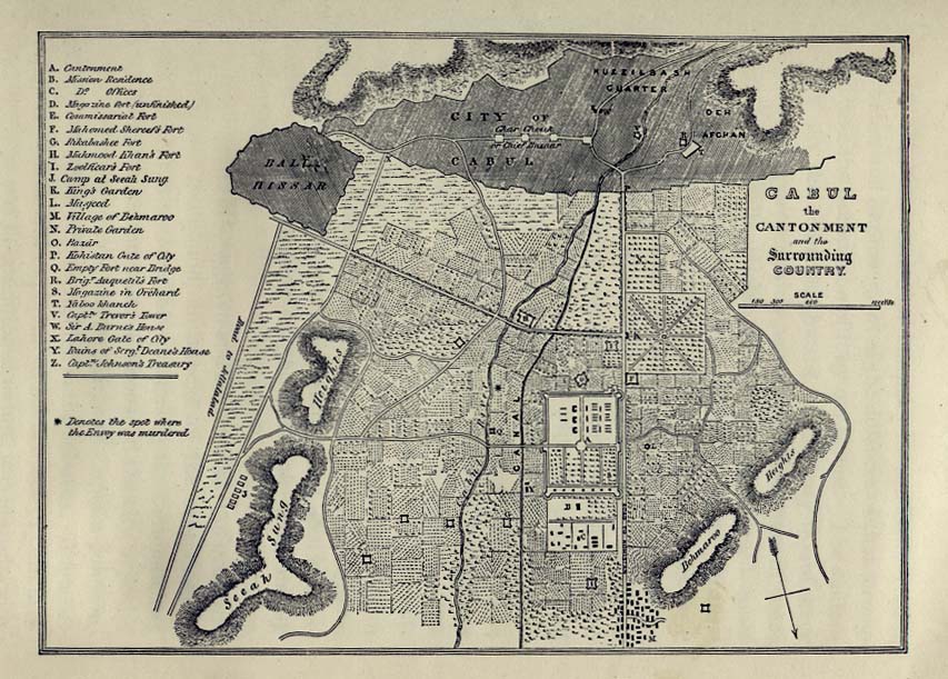
- Cabul, The Cantonment (134K)
- The Second Afghan War 1878-1880:
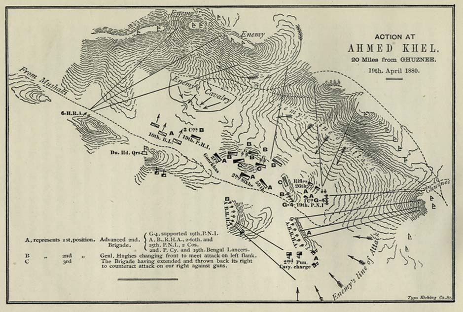
- Ahmed Khel, Plan of Action (118K)
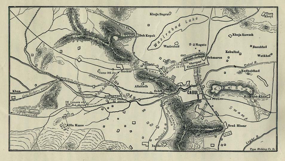
- Cabul, Actions at (124K)
- Candahar [Kandahar], Battle at (147K)
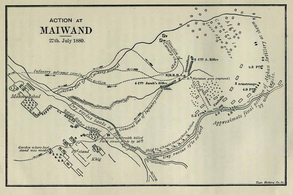
- Maiwand, Actions at (96K)
- Cabul, The Cantonment (134K)
- Afghanistan and Persia 1856 (1.4MB)
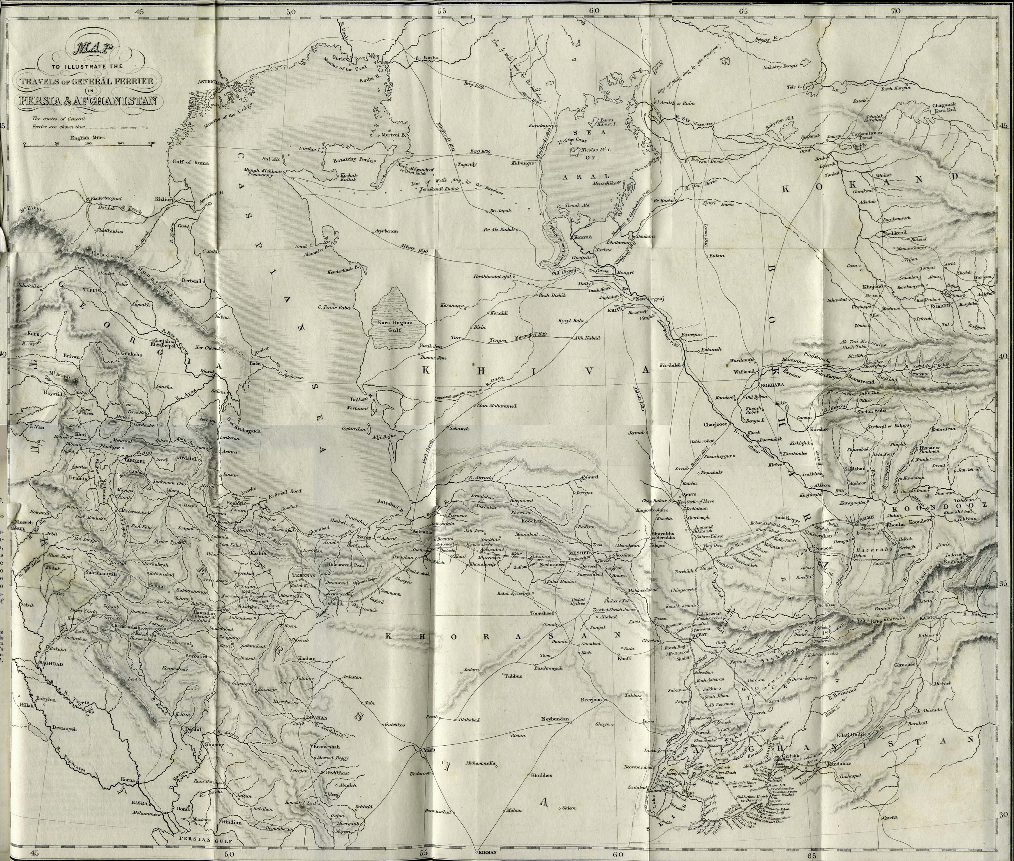
- "Map to Illustrate the Travels of General Ferrier in Persia and Afghanistan" from Caravan Journeys and Wanderings in Persia, Afghanistan, Turkistan, and Beloochistan; with Historical Notices of the Countries Lying Between Russia and India by Joseph Pierre Ferrier. Second Edition 1857.
- [Ambon, Netherlands East Indies] Tan Toey Prisoners of War Camp 1943
- "Sketch Map of Tan Toey Prisoners of War Camp, Amboina Island, Former camp of the Australian troops, built by the Netherlanders,
now used by the Japanese as a prisoner-of-war camp..." from Allied Geographical Section, Southwest Pacific Area. Area Study of Ambon Island, Terrain Study No. 45, Map 13 dated March 13, 1943. (429K)
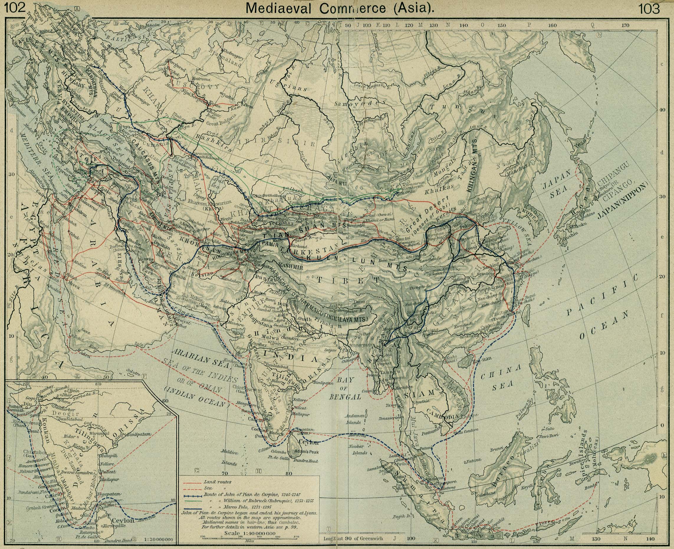
- Asia Medieval Commerce (596K)
- "Mediaeval Commerce (Asia)" From The Historical Atlas by William R. Shepherd, 1926.
- Inset: India.
- Inset: India.
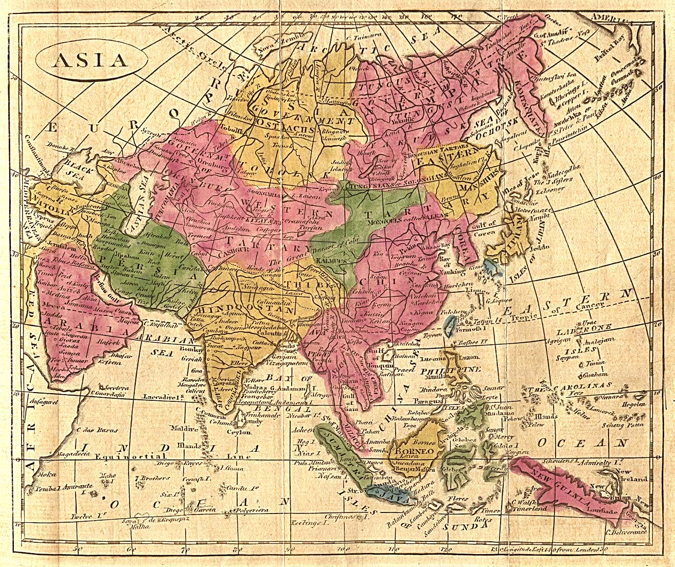
- Asia 1808 (596K)
- "Asia" from The General Gazetteer; or Compendious Geographical Dictionary by R. Brookes. Eighth Edition. Dublin, 1808.
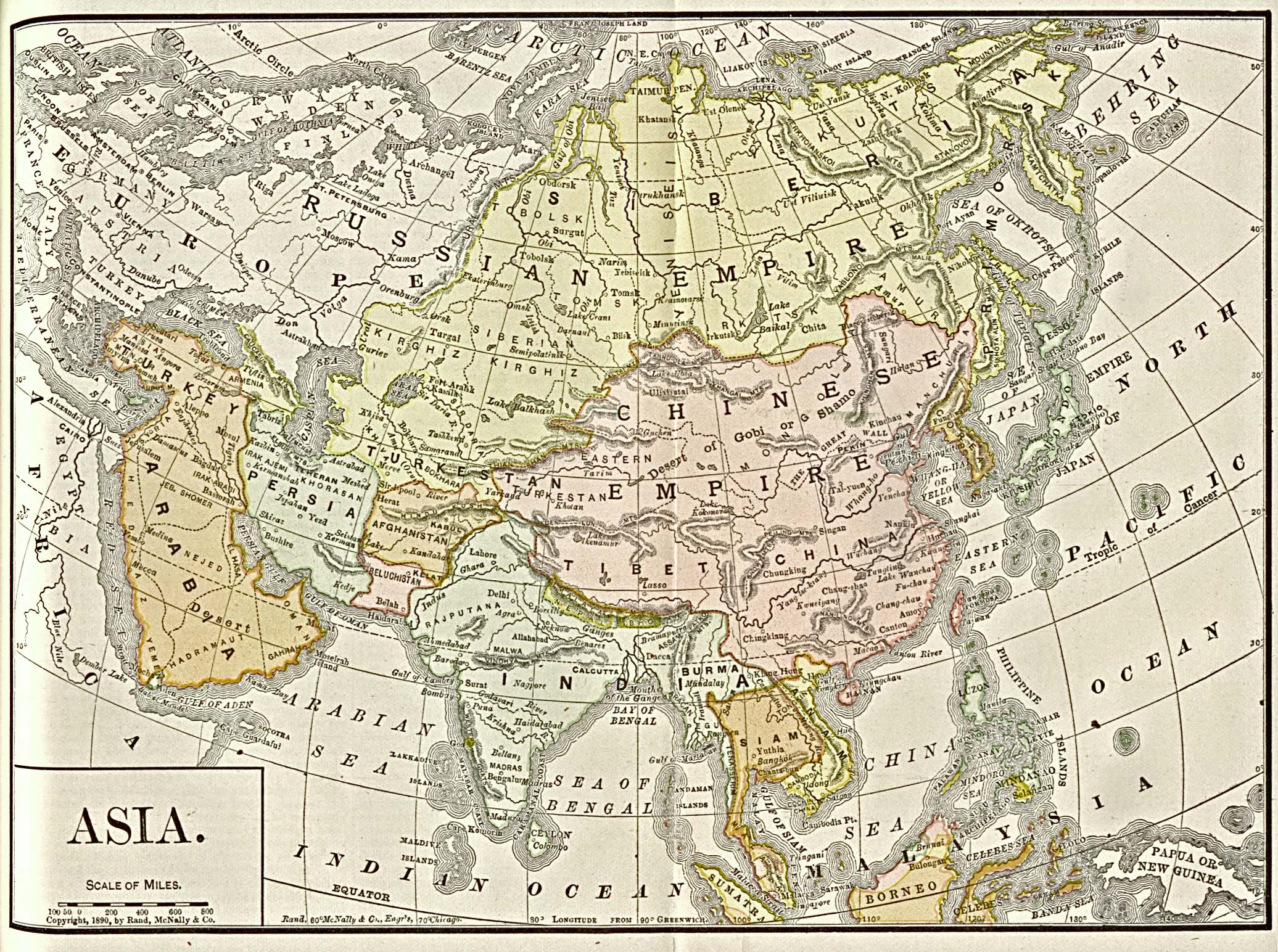
- Asia 1892 (779K)
- "Asia" from Americanized Encyclopaedia Britannica, Vol.1, Chicago 1892.
- Batavia [Jakarta] 1897 (516K)
- From Guide to the Dutch East Indies by Dr. J.F. van Bemmelen and G.B. Hoover, Luzac & Co, London 1897.
- Beijing Maps see China Historical Maps Page
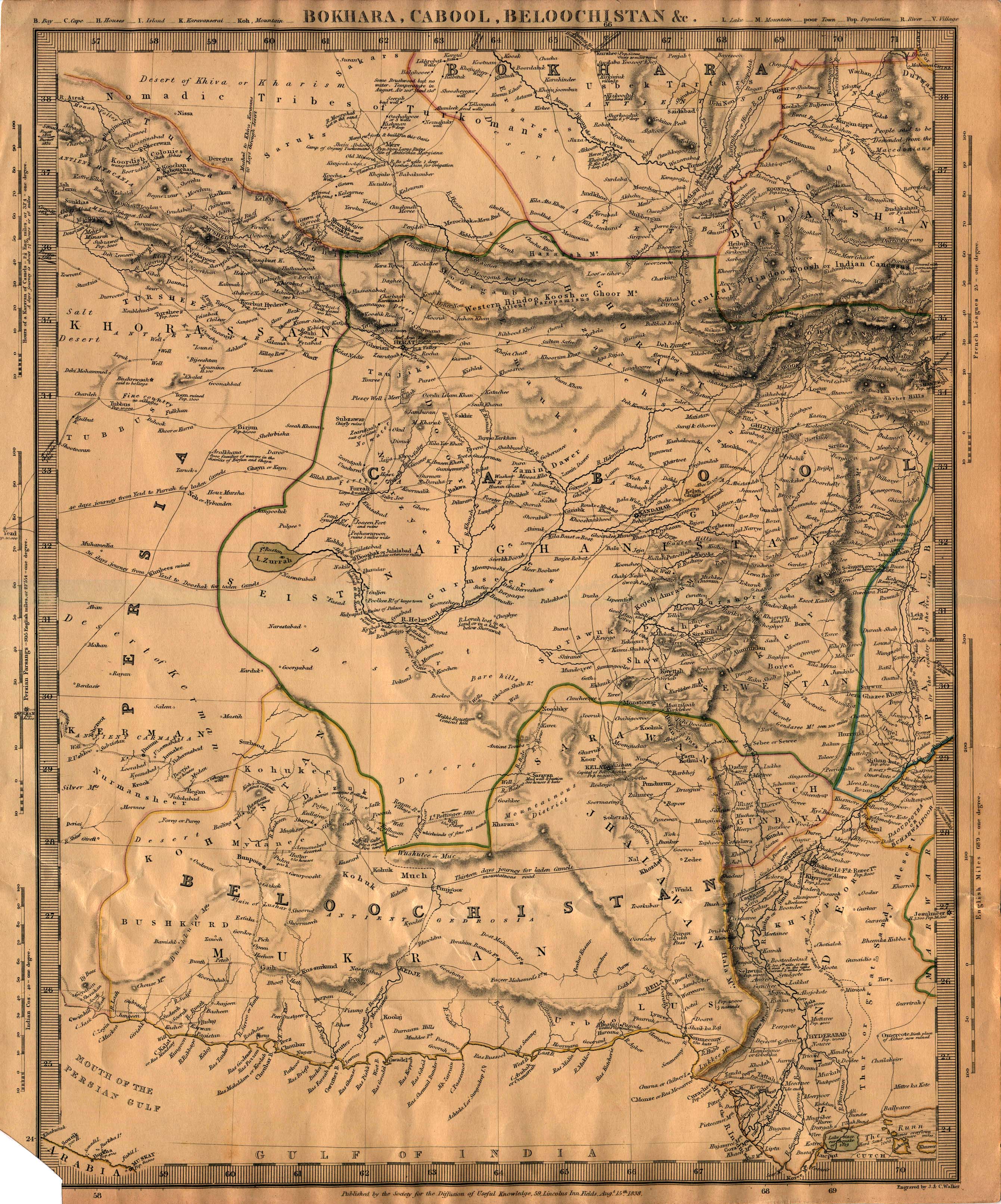
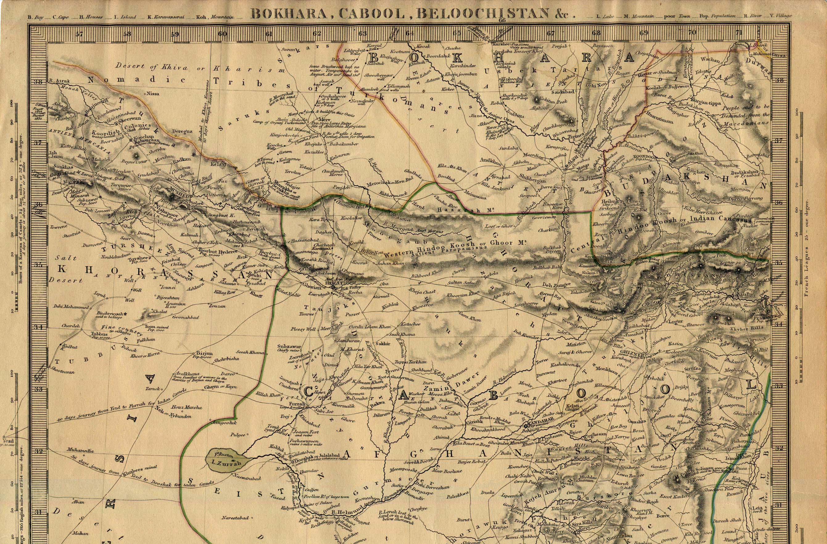
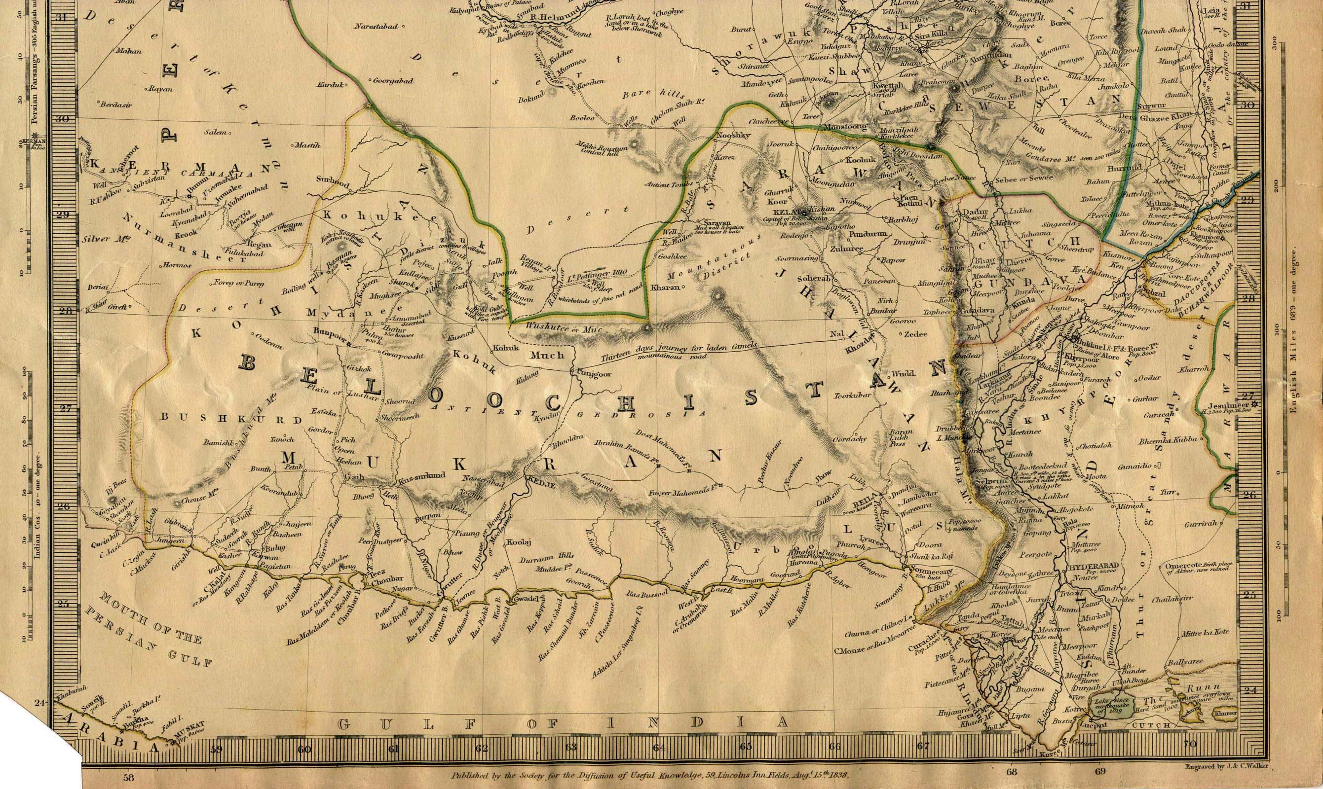
- Bokhara Cabool Beloochistan (1.7MB) Northern Part of Map (987K) Southern Part of Map (744K)
- Published by the Society for the Diffusion of Useful Knowledge, 1838.
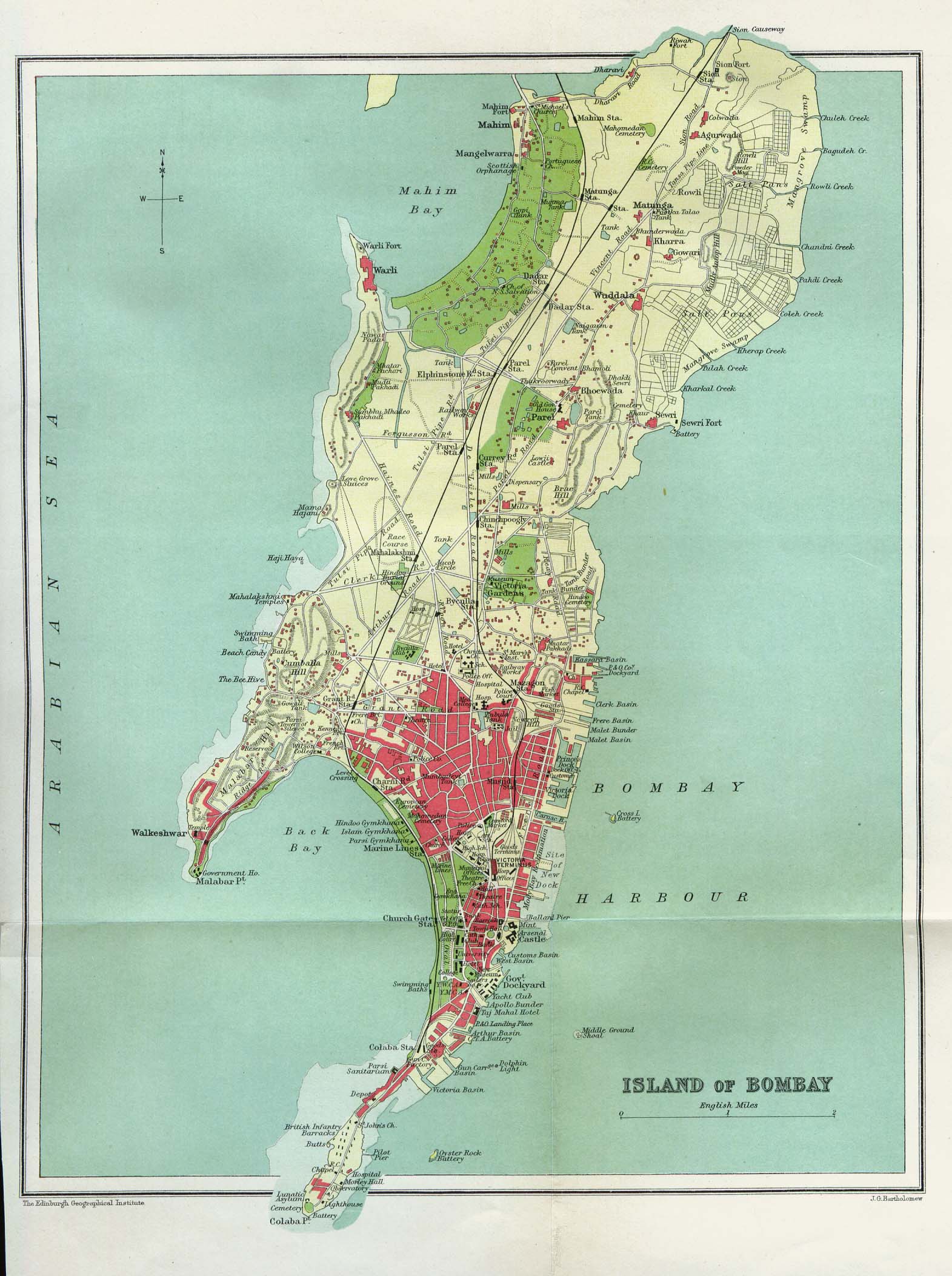
- Bombay 1909 (386K)
- "Island of Bombay" from The Gazetteer of Bombay City and Island. Volume 1. Bombay, India 1909.
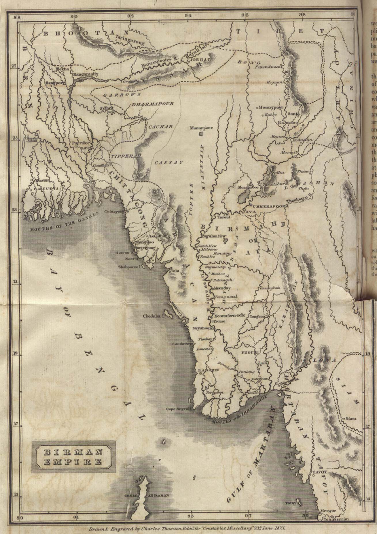
- Burma 1827
- "Birman Empire" from An Account of an Embassy to the Kingdom of Ava in the Year 1795 by Lieut Colonel Michael Symes, to which is now added, A Narrative of the Late
Military and Political Operations in the Birmese Empire...Volume II. Printed for Constable and Co. 1827.
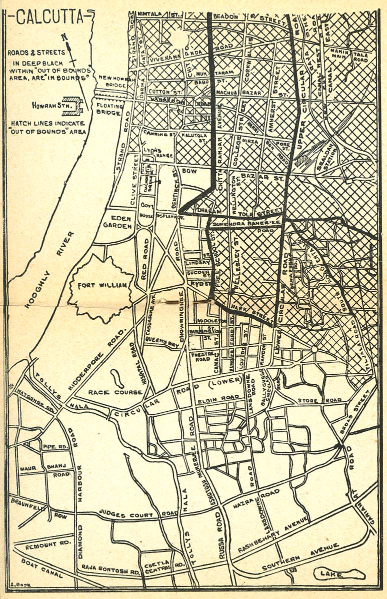
- Calcutta 1945 (356K)
- City plan from The Calcutta Key: Welcome United States Army. United States Army Forces in India-Burma, Information and Education Branch. Calcutta, 1945
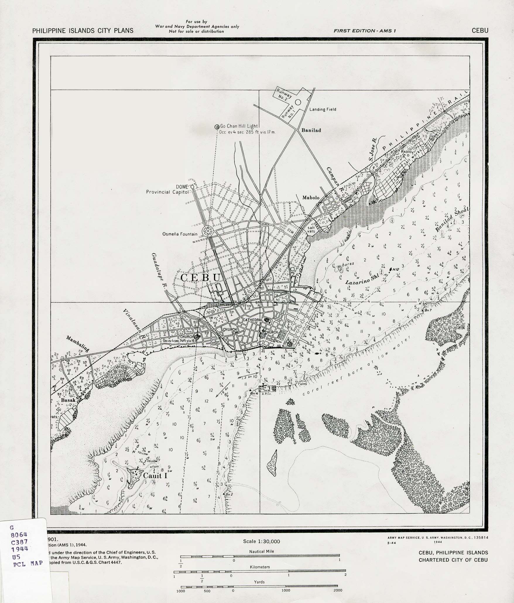
- Cebu, Philippines 1944 (524K)
- Published by U.S. Army Map Service, 1944.
- Ceylon [Sri Lanka] 1914 (774K)
- "Ceylon" from Great Britain Parliament House of Commons Sessional Papers, Colonial Reports - Annual. No. 797. Ceylon. Report (Supplementary) for 1912.
- China Historical Maps Page
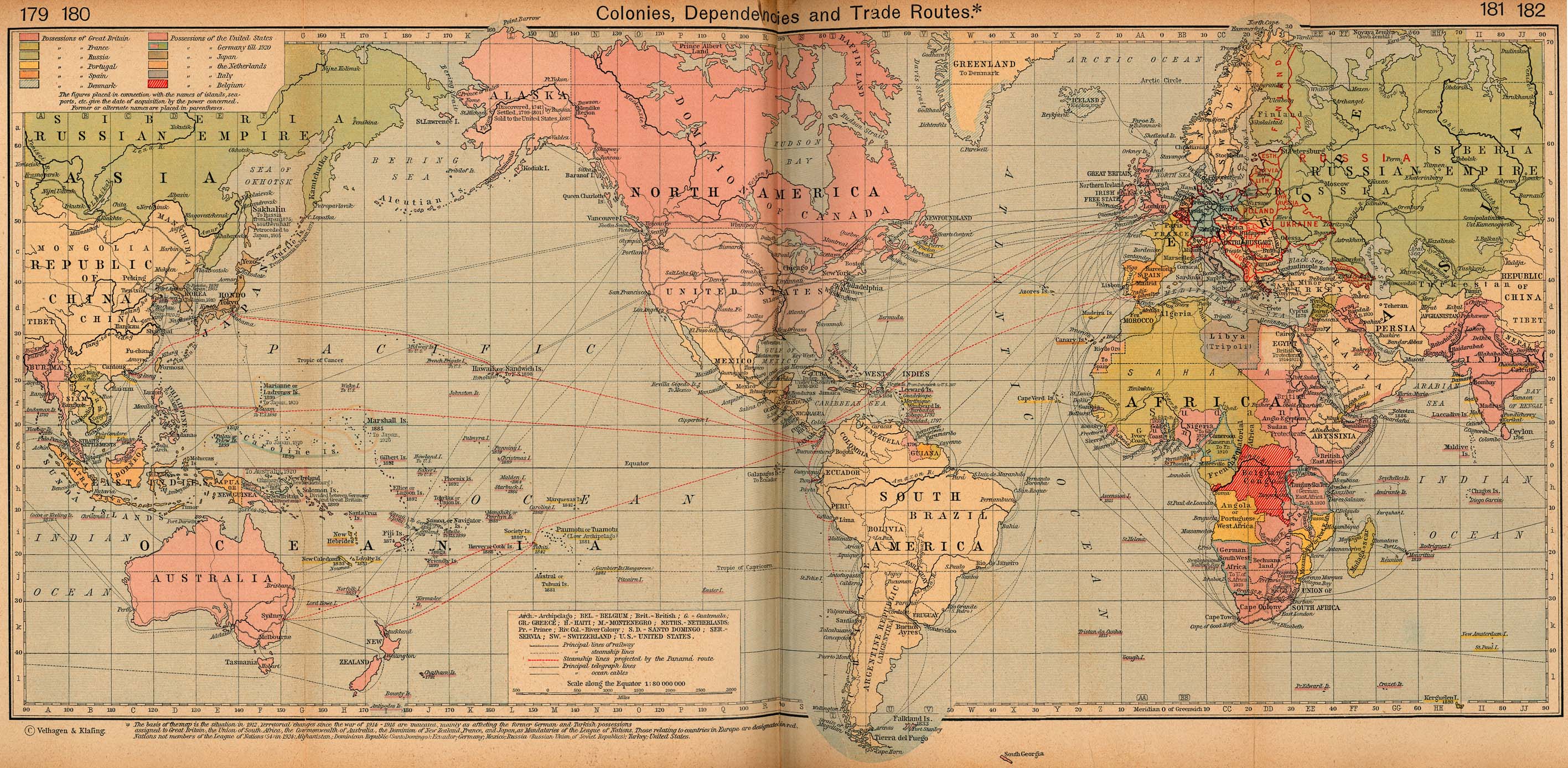
- Colonies, Dependencies and Trade Routes, 1912 (892K)
- From The Historical Atlas by William R. Shepherd, 1926.
- Edo [Tokyo] 1844-1848
- Formosa [Taiwan] 1896 (439K)
- From the Scottish Geographical Magazine. Published by the Royal Scottish Geographical Society and edited by James Geikie and W.A. Taylor. Volume XII, 1896.
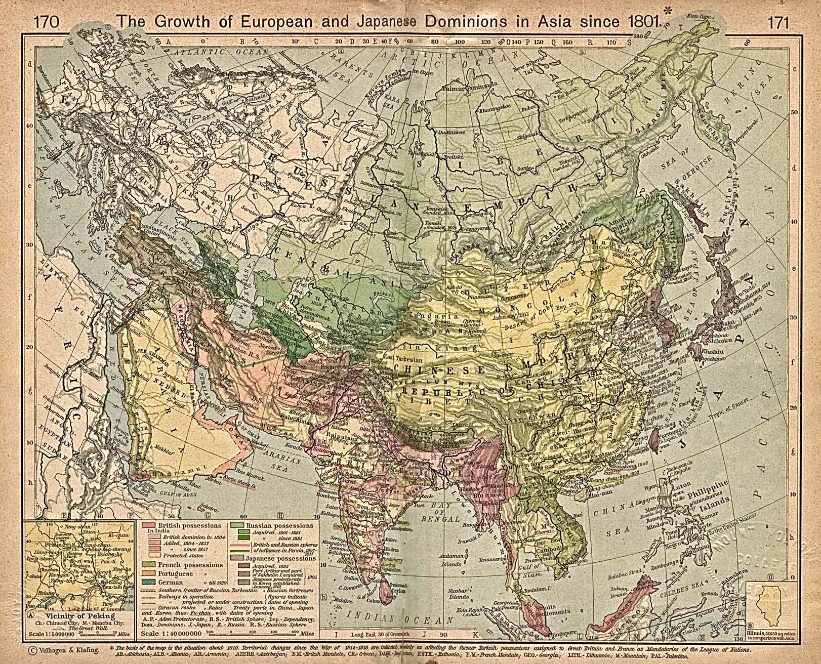
- The Growth of European and Japanese Dominions in Asia since 1801 (839K)
- Inset: Vicinity of Peking. From The Historical Atlas by William R. Shepherd, 1923.
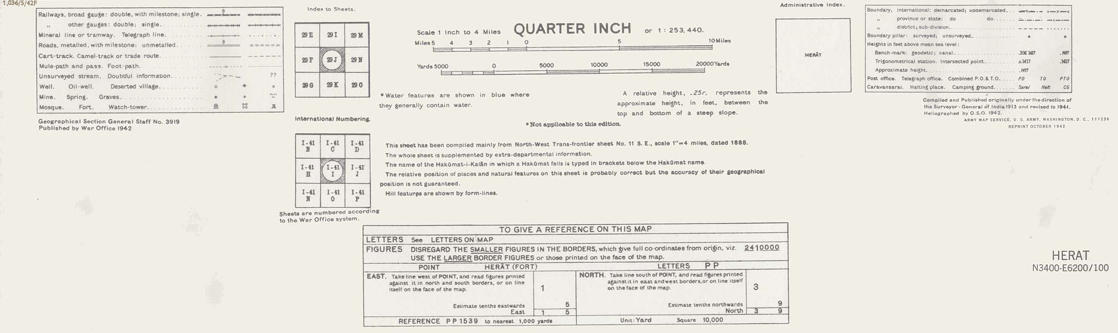
- Herat Area, Afghanistan 1942 (509K)
- Portion of sheet I-41I Herat. Original scale 1:253,440 Compiled and published originally
under the direction of the Surveyor-General of India 1913 and Revised to 1941. Published by the War Office, 1942 and reprinted by the
U.S. Army Map Service October 1942. map key and scale (129K)
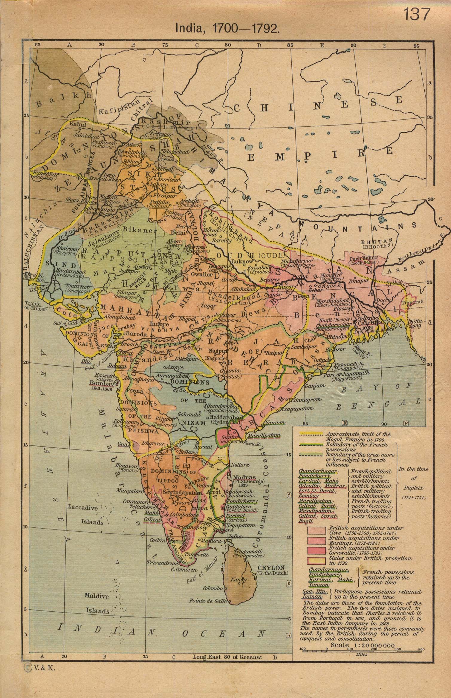
- India 1700-1792 (645K)
- From The Historical Atlas by William R. Shepherd, 1923.
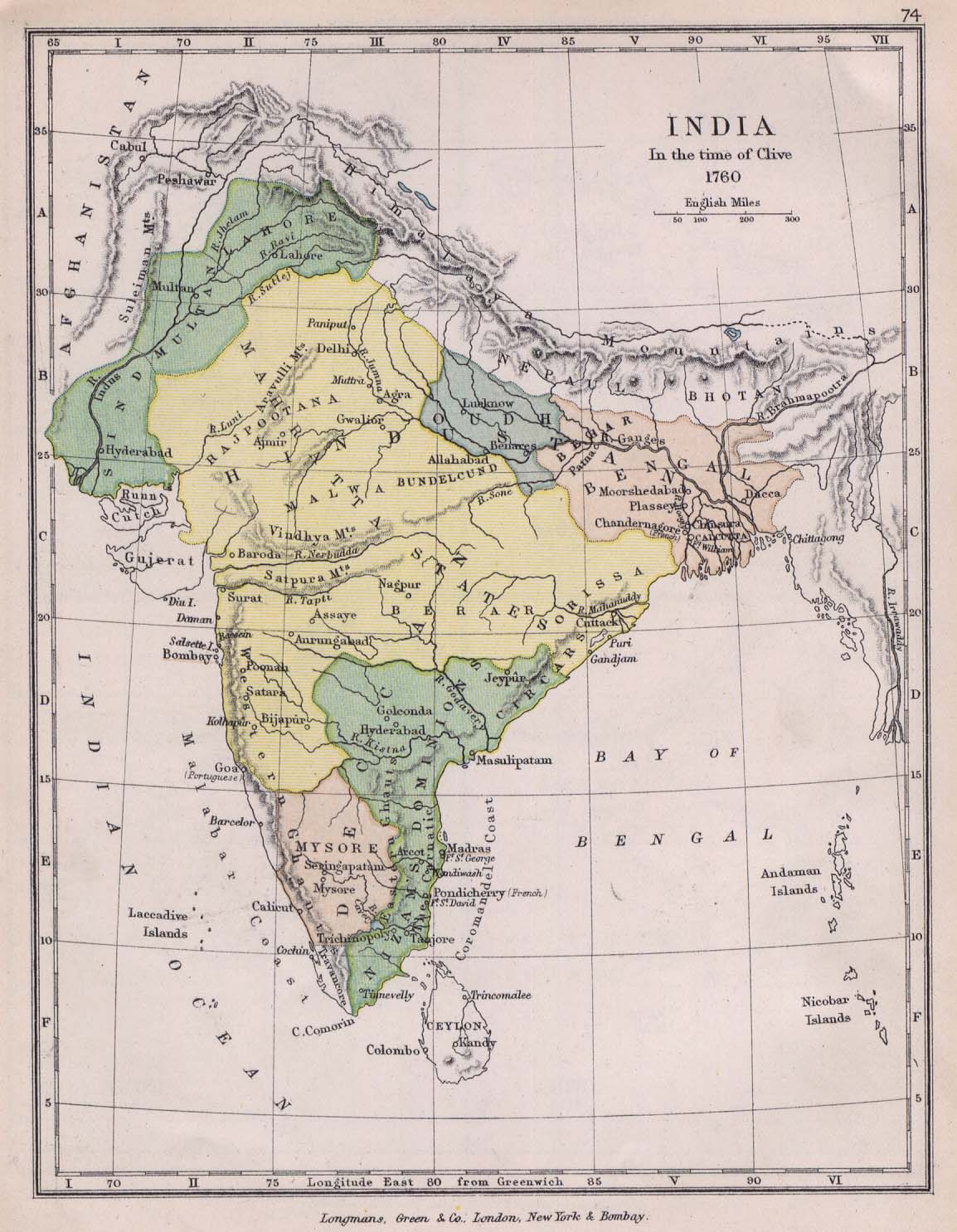
- India 1760 (222K)
- From The Public Schools Historical Atlas edited by C. Colbeck. Longmans, Green, and Co. 1905.
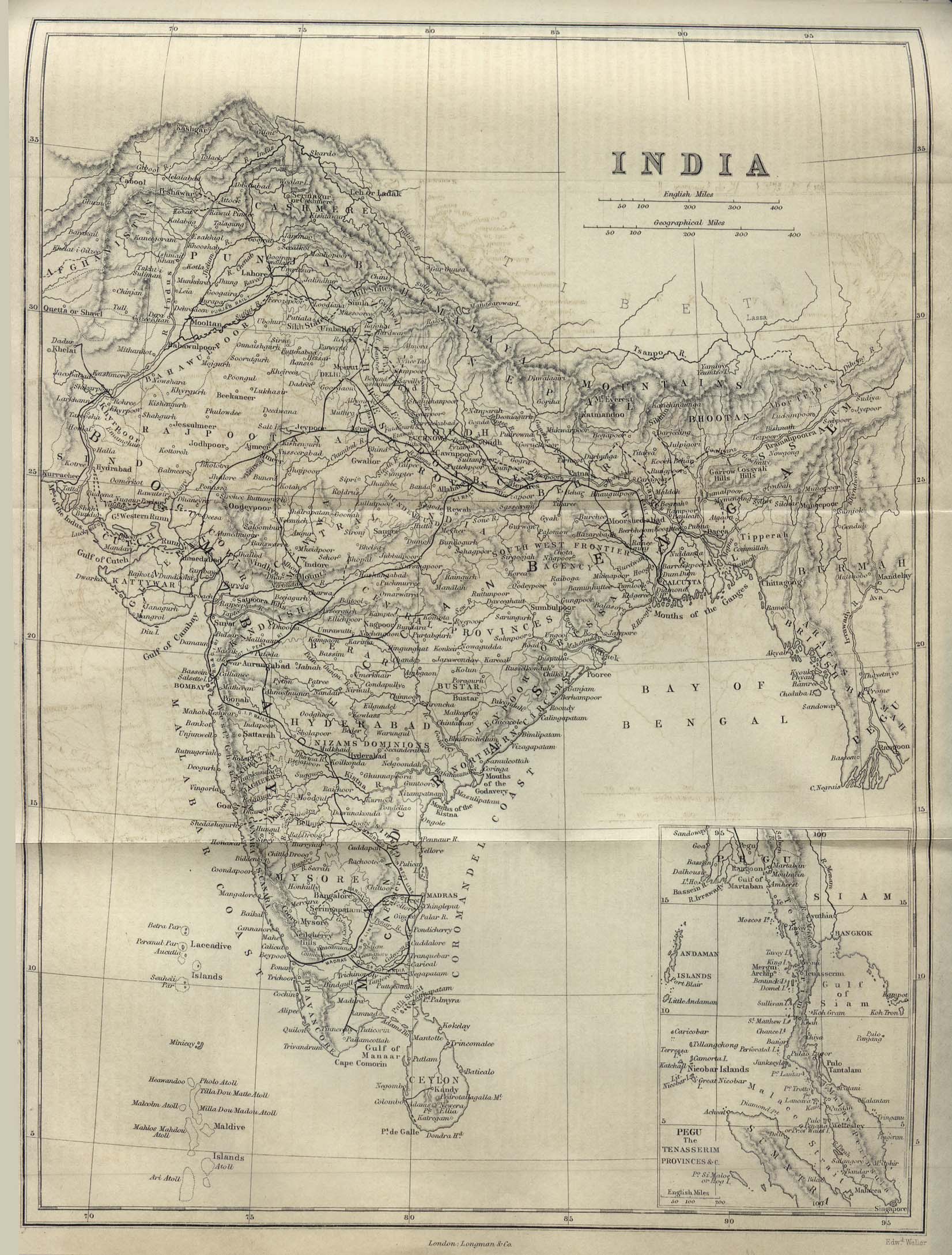
- India 1882 (555K)
- From A Dictionary Practical, Theoretical, and Historical of Commerce and Commercial Navigation by J.R. M'Culloch. Longmans, Green and Co. London, 1882.
- India 1914
- Maps from "Indien: Handbuch F�r Reisende". Verlag von Karl Baedeker, Leipzig, 1914. Maps include stops on the outbound voyage from Egypt including Port Said, Suez Canal, Red Sea and Aden as well as maps of India, Ceylon, Burma, Malay Peninsula, Singapore, Bangkok and the Dutch East Indies.
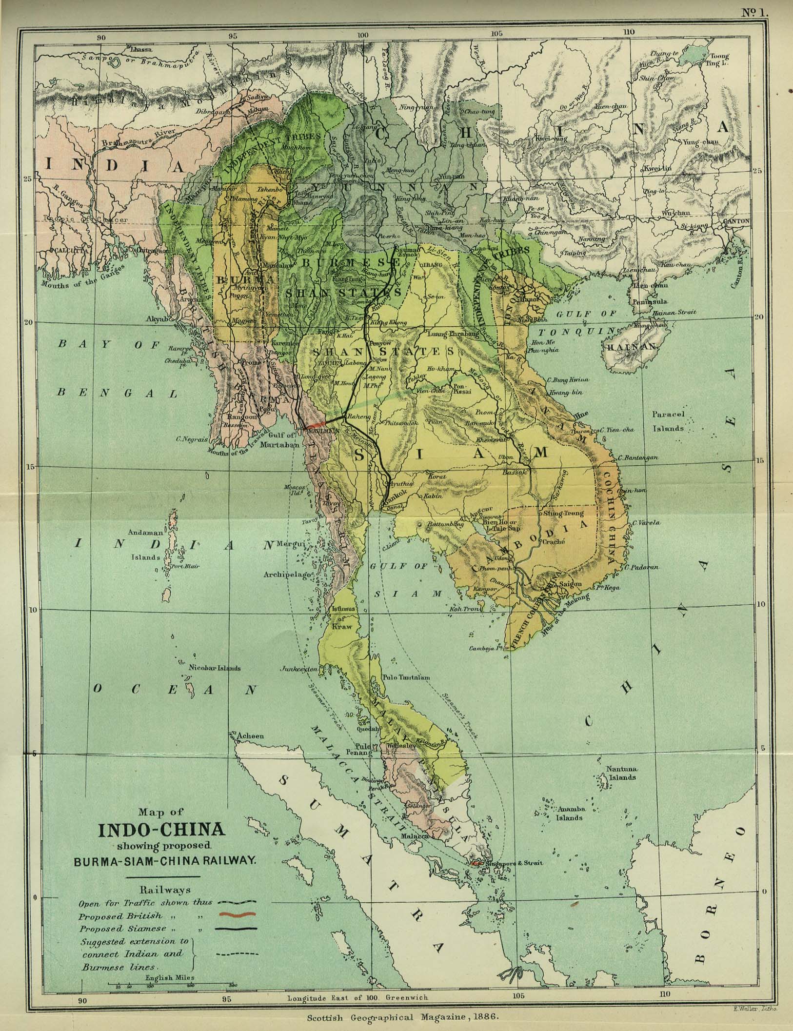
- Indo-China 1886 (533K)
- "Map of Indo-China showing proposed Burma-Siam-China Railway" from the Scottish Geographical Magazine. Published by the Scottish Geographical Society and edited by Hugh A. Webster and Arthur Silva White. Volume II, 1886.
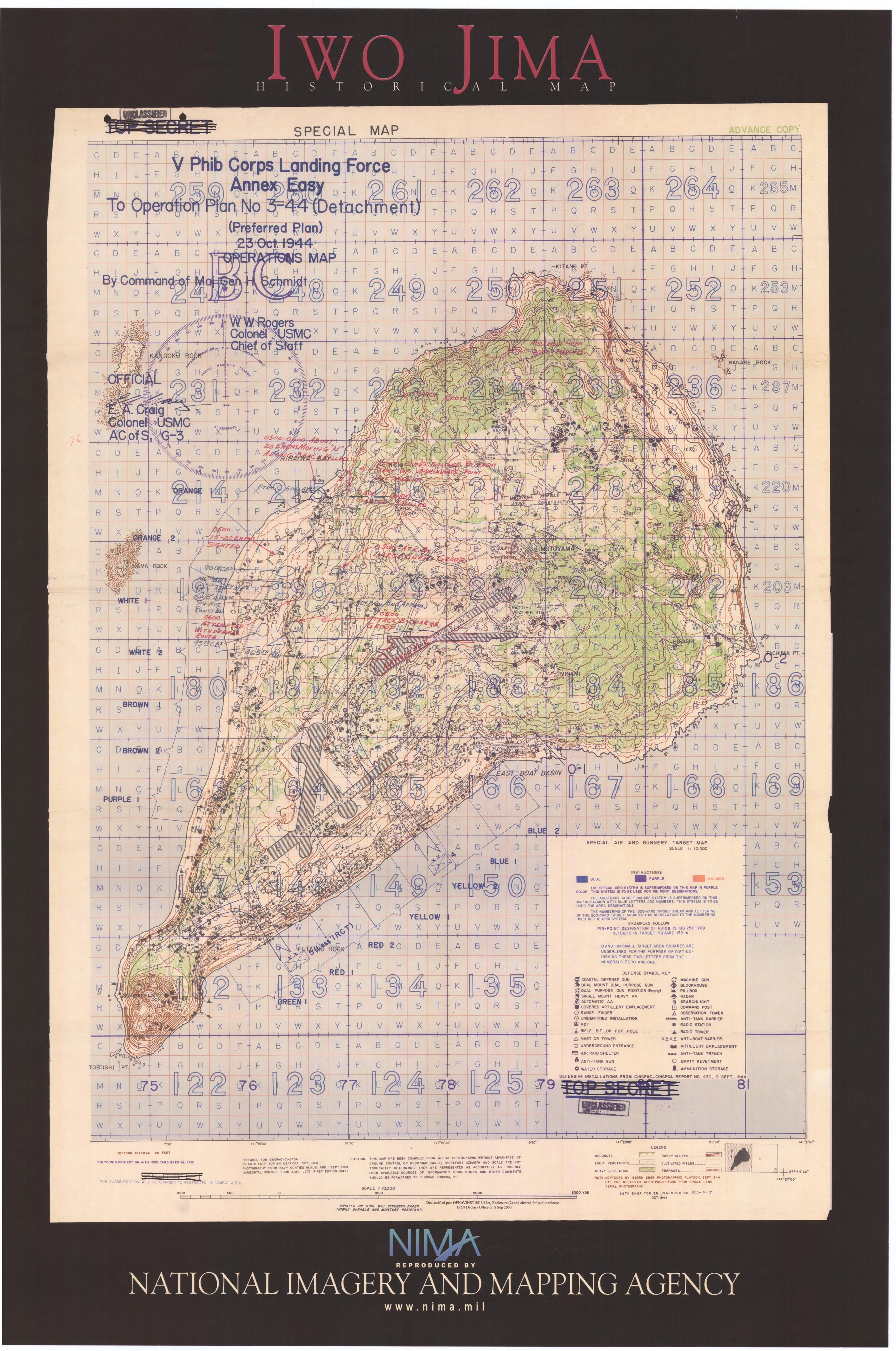
- Iwo Jima 1944 (1.8MB)
- "Iwo Jima Historical Map" [poster] National Imagery and Mapping Agency, 2003.
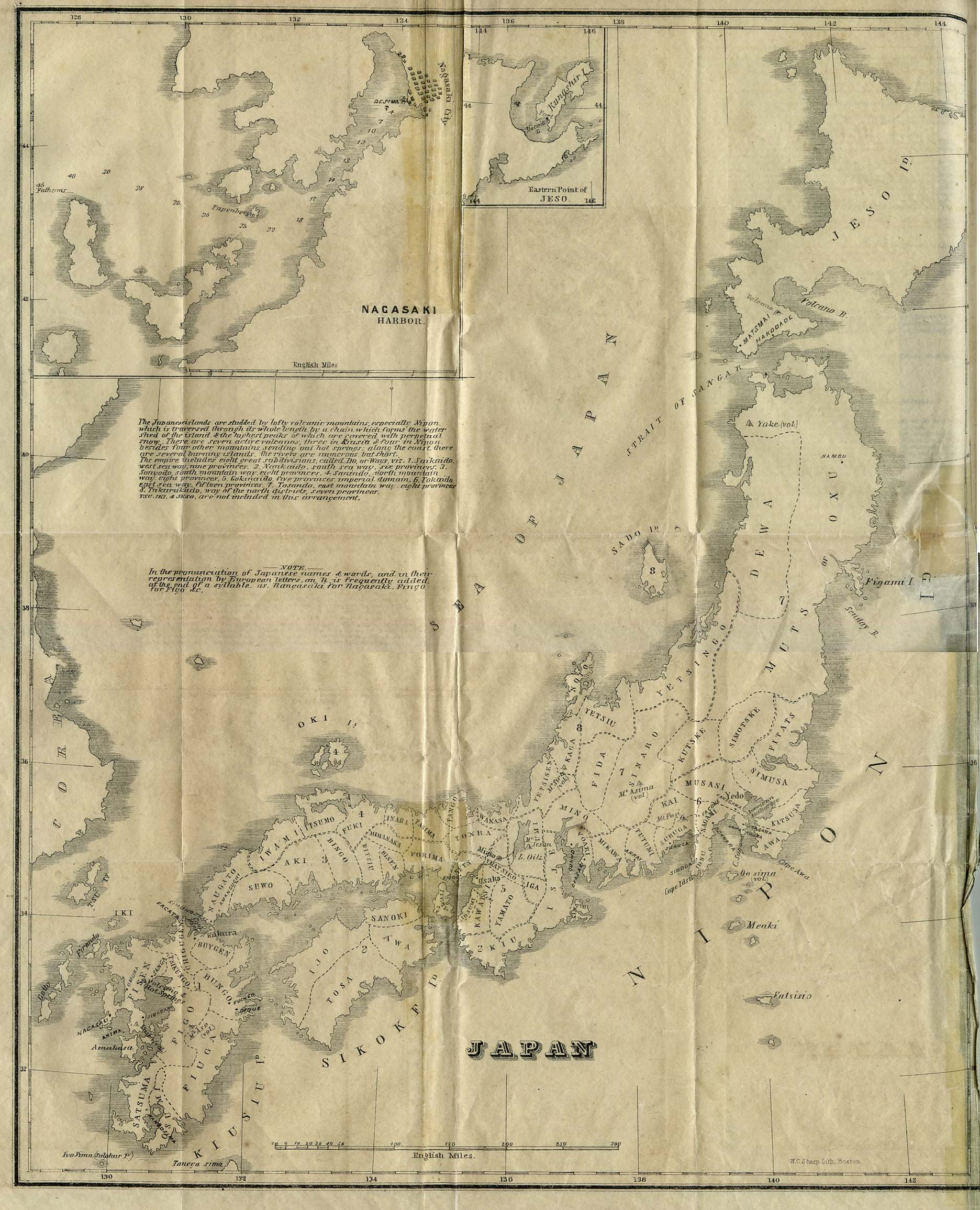
- Japan 1855 (548K)
- From Japan as it was and is by Richard Hildreth. Phillips, Sampson, and Company 1855.
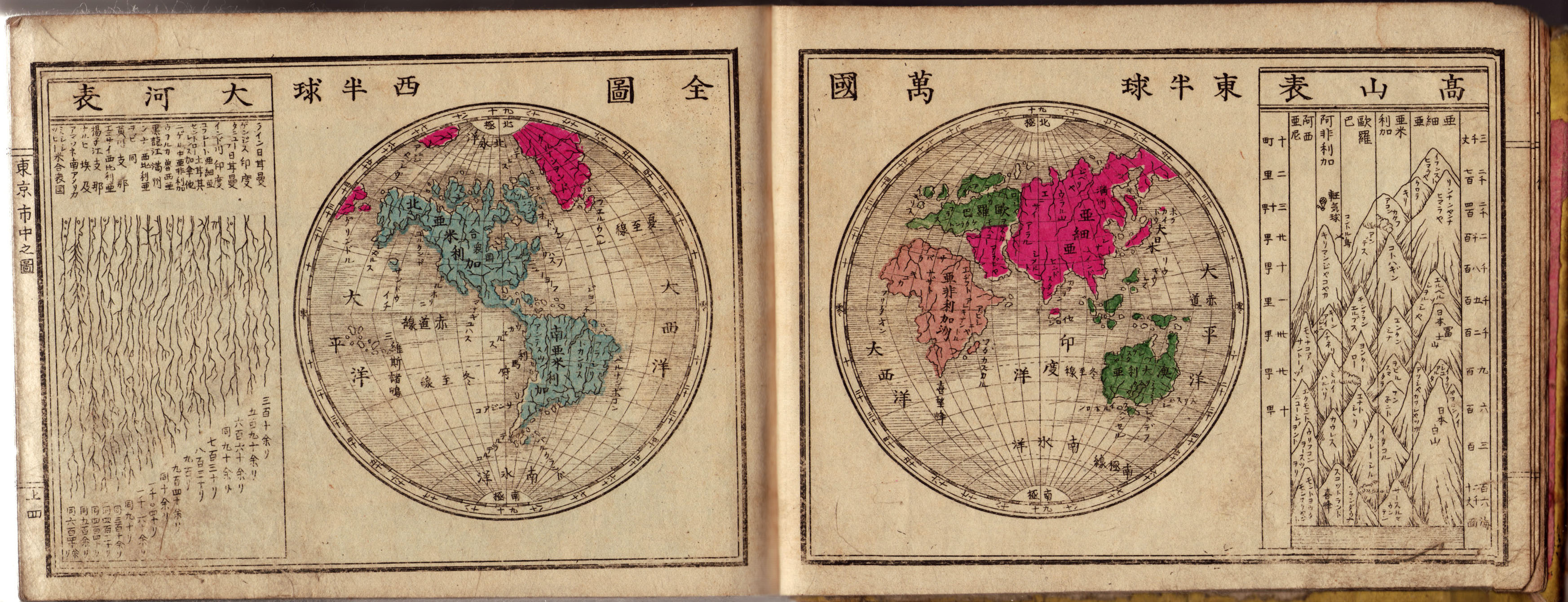
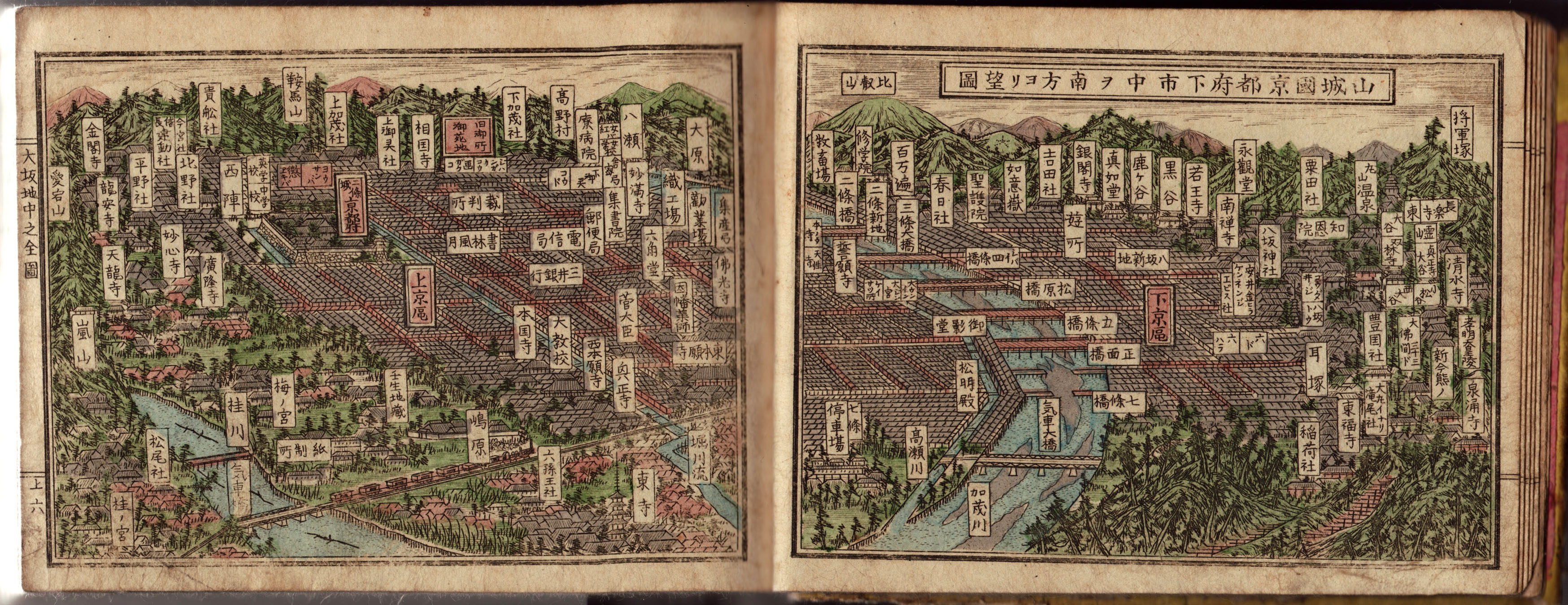
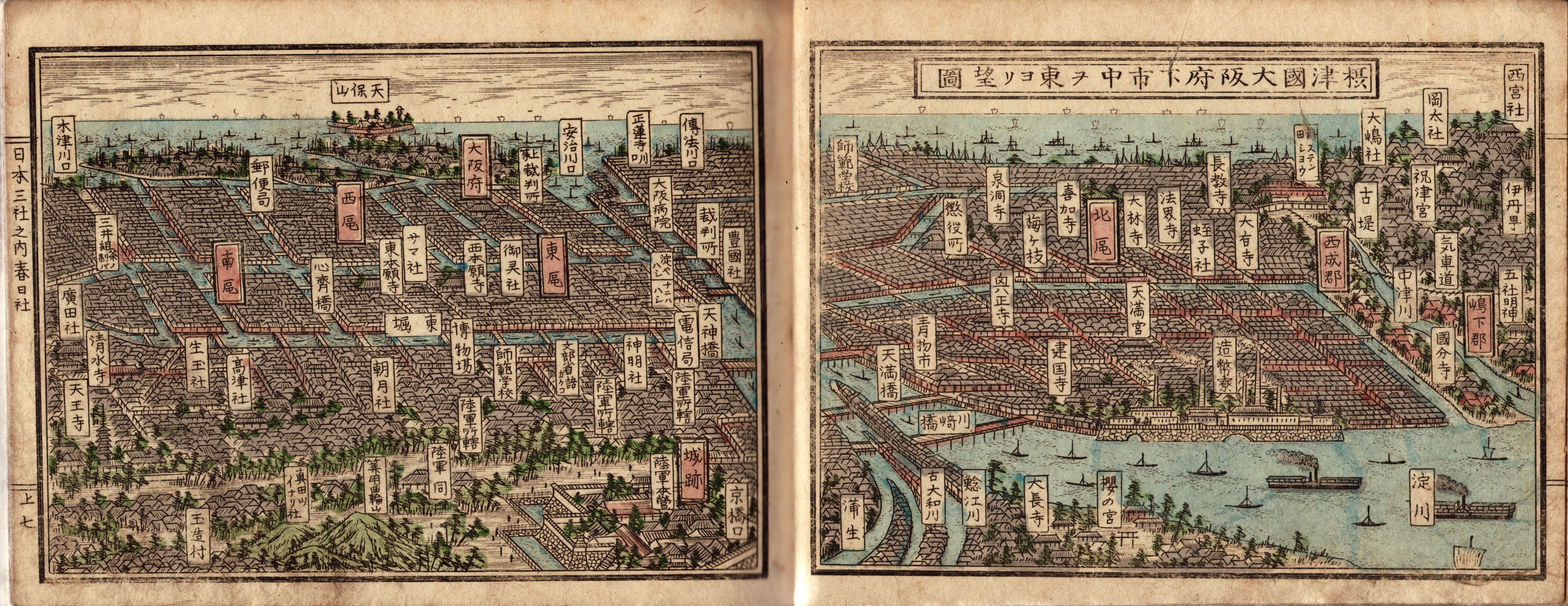
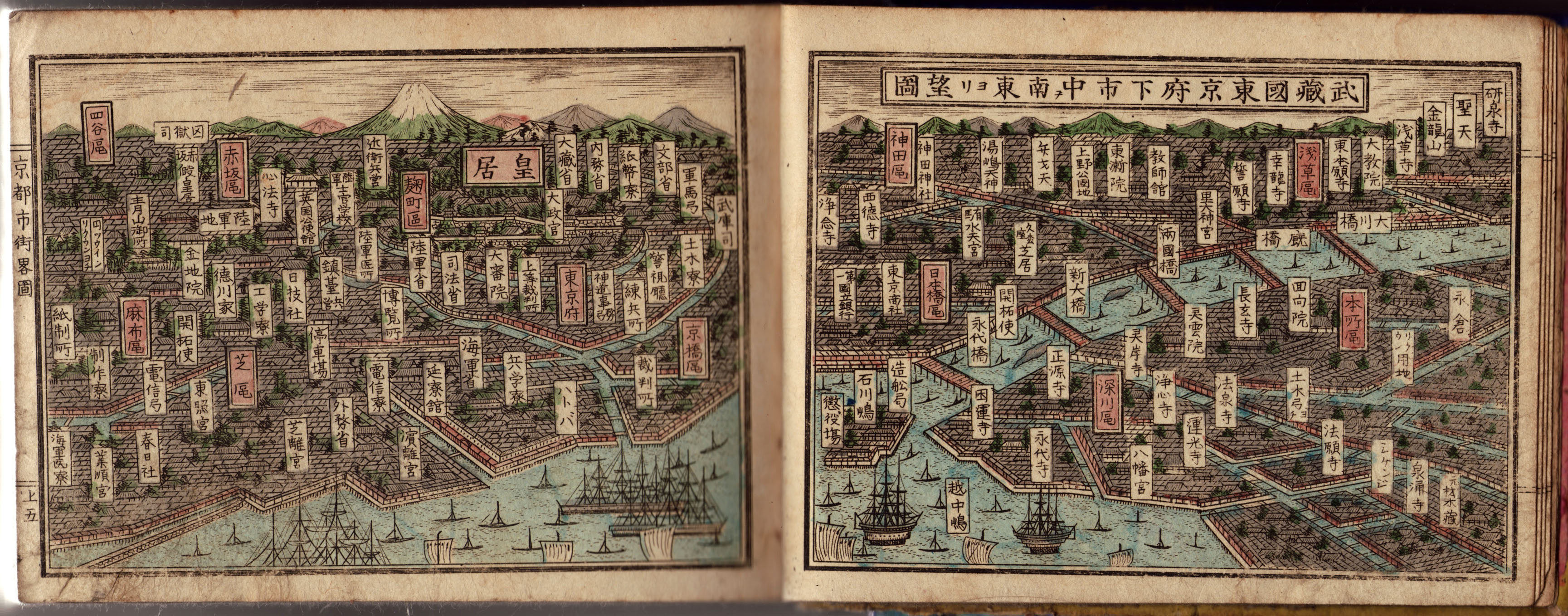
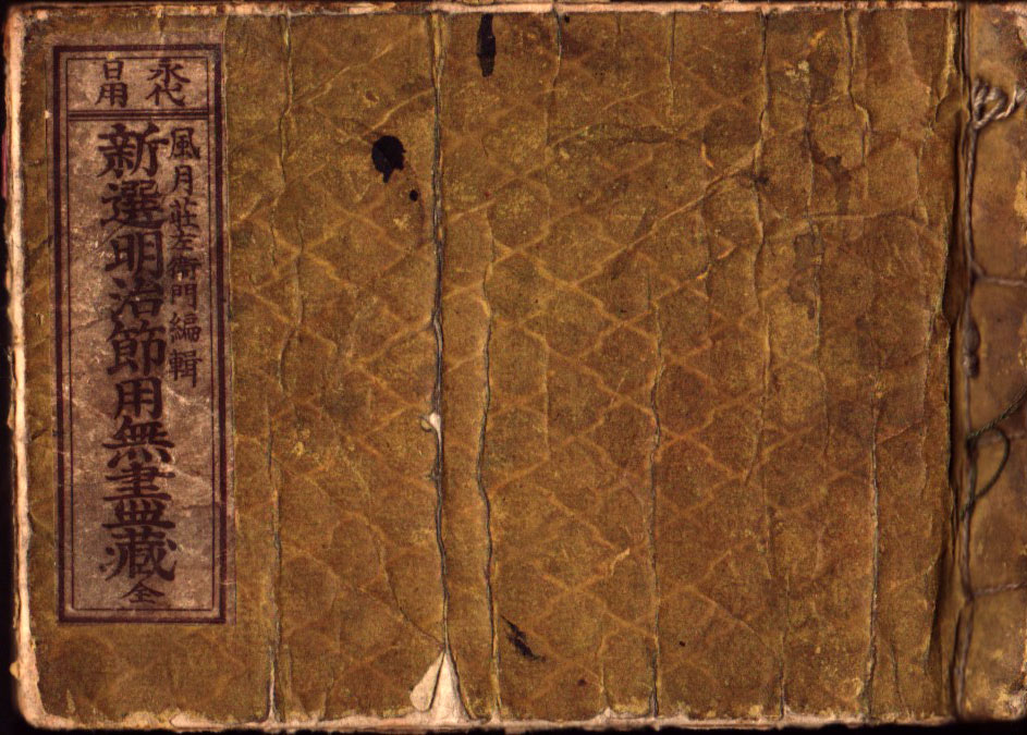
- Japan 1883
- The following maps are from an almanac published by Fuugetsu Shouzaemon, Kyoto, 1883 (16th year of the Meiji Era):
- World Map (1.1MB)
- Kyoto panoramic view (1.4MB)
- Osaka panoramic view (1.3MB)
- Tokyo panoramic view (1.3MB)
- Almanac Front Cover (218KB)
- Almanac Title Page (256KB)
- Almanac Endpaper (245KB)
- Our thanks go to Juan Ysidro Tineo Alvarado for providing these map scans and translations.
- World Map (1.1MB)
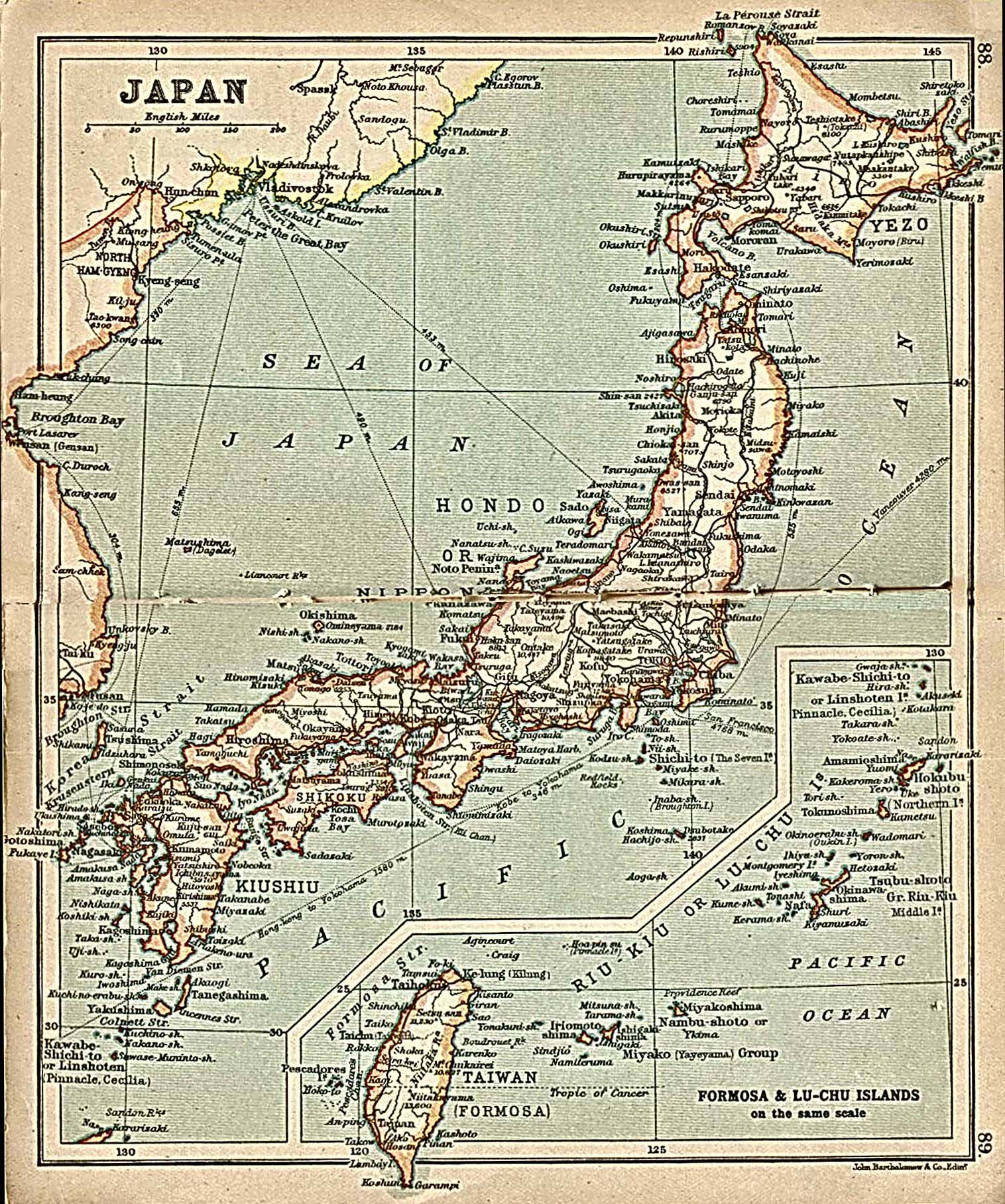
- Japan 1912 (452K)
- "Japan" with inset map "Formosa and Lu-Chu Islands"
from A Literary and Historical Atlas of Asia, by J.G. Bartholomew. J.M. Dent and Sons, Ltd. 1912
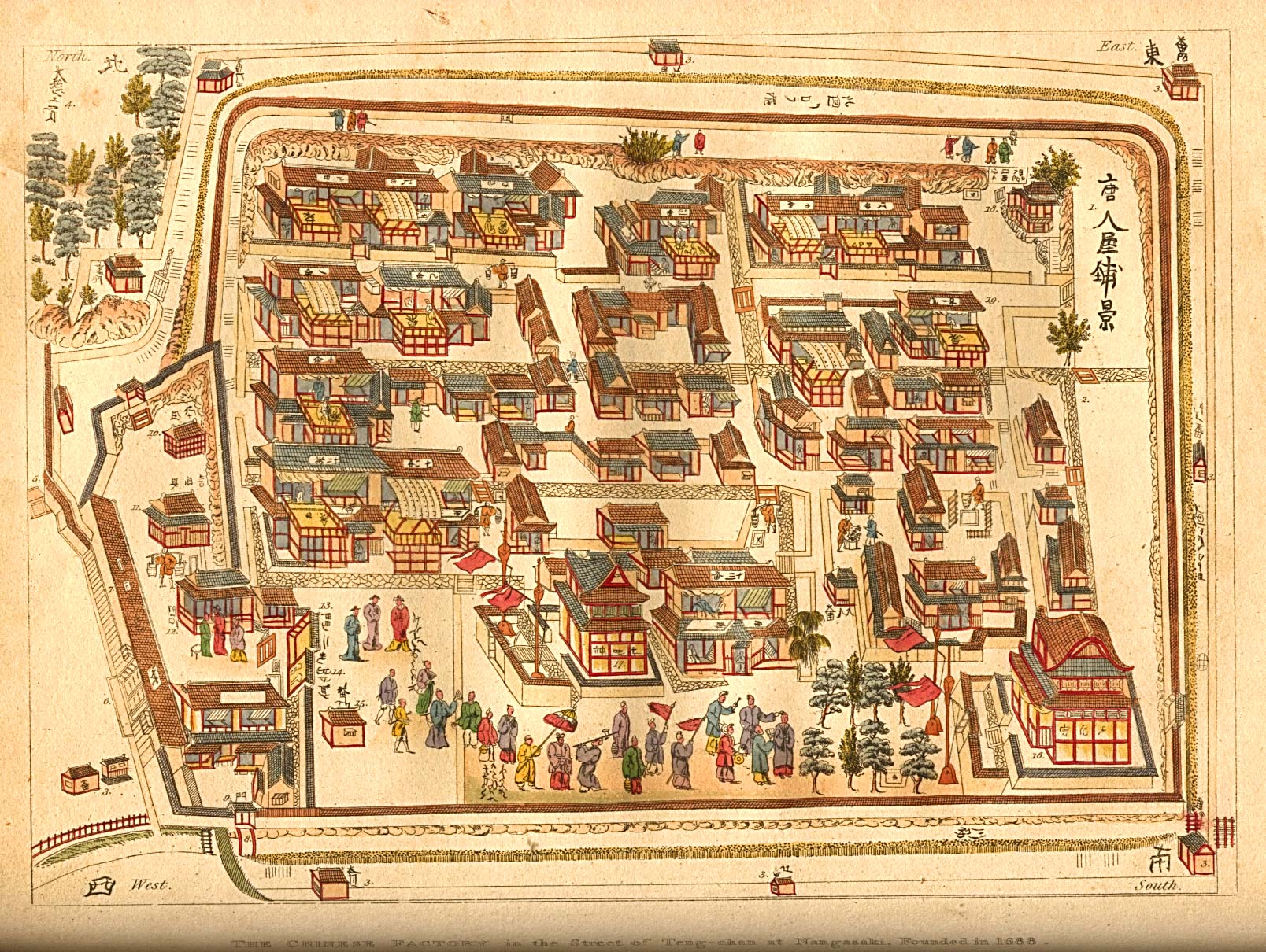
- Japan - "The Chinese Factory in the Street of Teng-chan at Nagasaki, founded in 1688."
- [Note: During the period of Japanese seclusion, the Chinese, like the Dutch, were allowed to reside and trade in a restricted area in Nagasaki.]
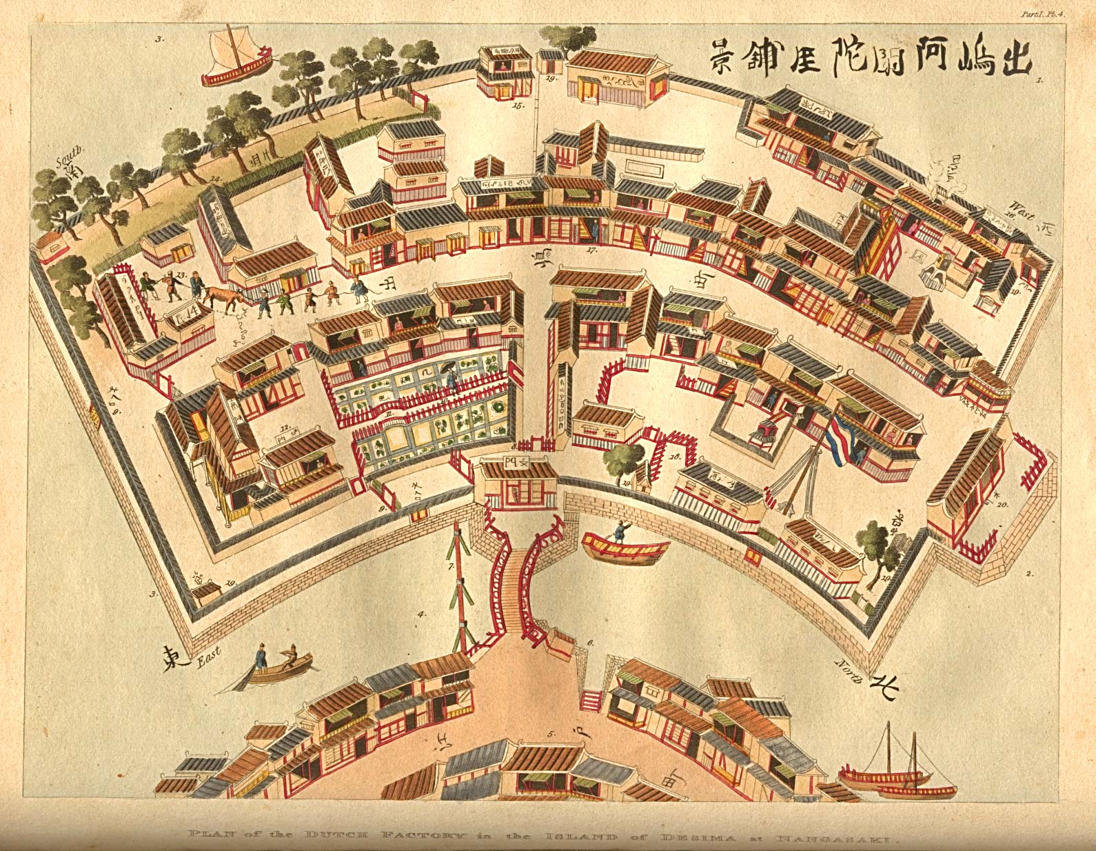
- Japan - "Plan of the Dutch Factory in the Island of Desima at Nagasaki."
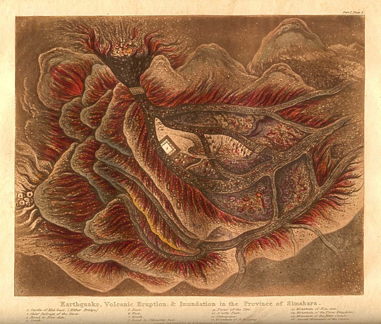
- Japan - "Earthquake, Volcanic Eruption and Inundation in the Province of Simahara."
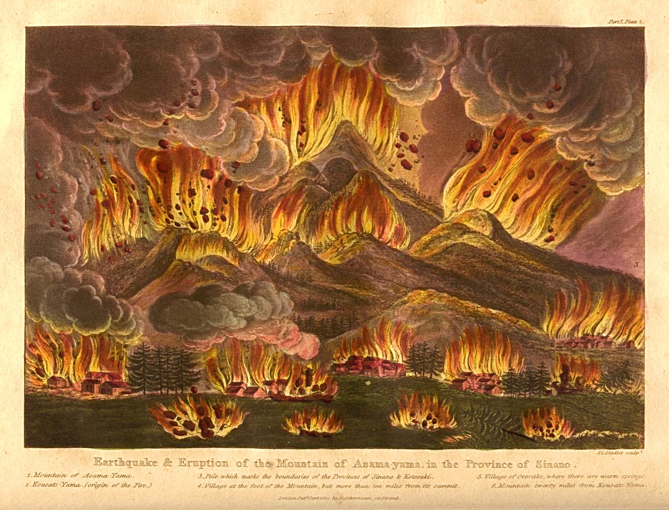
- Japan - "Earthquake and Eruption of the Mountain of Asama-yama, in the province of Sinano."
- Japan - "Earthquake, Volcanic Eruption and Inundation in the Province of Simahara."
- These four map images are from "Illustrations of Japan consisting of private memoirs and anecdotes of the reigning dynasty of the Djogouns, or sovereigns of Japan..." by Isaac Titsingh, London: R. Ackermann, 1822.
- [Japan - Aonohara Military Training Fields] 1900 (3.8MB)
- Published by Sasayama Mankando Osame, 1900 (33rd Year, Meiji era). Takaoka Shosha (Takaoka Military Barracks), upper red dot. Daimon Shosha (Daimon Military Barracks), lower red dot. Nearly 500 Austrian and German prisoners of war, arrived in this area in September 1915, after they had been captured in the Japanese occupation of the former German colony of Tsingtao, China. Our thanks go to Juan Ysidro Tineo Alvarado for providing this map scan and research.
- [Korea] Chosen 1911 (5.6MB)
- Published by Suzuki Tsunejirou and Suzuki Tsunematsu, 1911 (44th year, Meiji Era). Depicts the political subdivision of the Chosen peninsula (Korea) under Japanese rule.
- Our thanks go to Juan Ysidro Tineo Alvarado for providing us with this map scan and translation.
- Our thanks go to Juan Ysidro Tineo Alvarado for providing us with this map scan and translation.
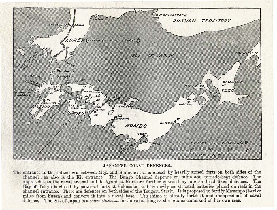
- Japanese Coast Defences 1907 (252K)
- From Imperial Outposts, from a Strategical and Commercial Aspect, with Special Reference to the Japanese Alliance, by Colonel A. M. Murray; published by John Murray, London 1907.
- Japan - Honshu 1874
- The following maps are from Shihan Gakkou henshuu [Teacher School Edition], Nihon Chishi Ryaku II [Japanese Topography Outline, Volume II]. Printed by the Ministry of Education, 1874 (7th year, Meiji Era). Our thanks go to Juan Ysidro Tineo Alvarado for providing these map scans and translations.
- [Northern Honshu region of Japan] Hokuriku 1874 - 1 (905KB)
- [Northern Honshu region of Japan] Hokuriku 1874 - 2 (703KB)
- Front Cover (183KB)
- Title Page (331KB)
- [Northern Honshu region of Japan] Hokuriku 1874 - 1 (905KB)
- Kyoto 1914 (3.6MB)
- Tourist map published by Fuugetsu Shouzaemon, 1914 (3rd year, Taisho Era). Our thanks go to Juan Ysidro Tineo Alvarado for providing this map scan and translation.
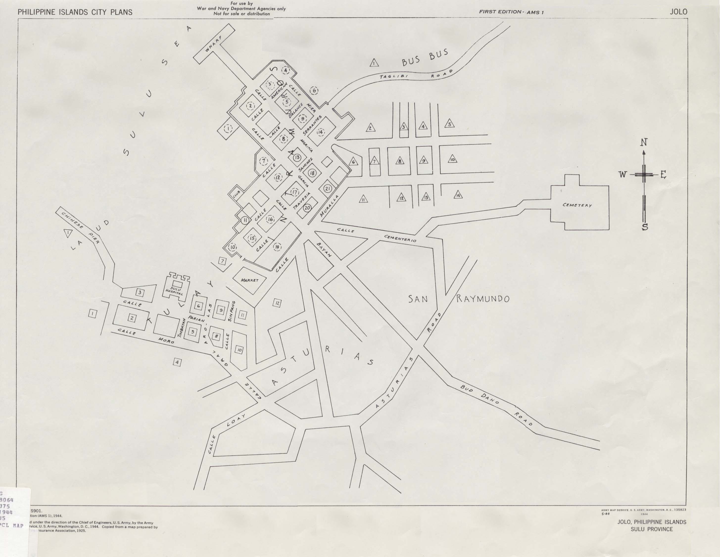
- Jolo, Philippines 1944 (266K)
- Published by U.S. Army Map Service, 1944.
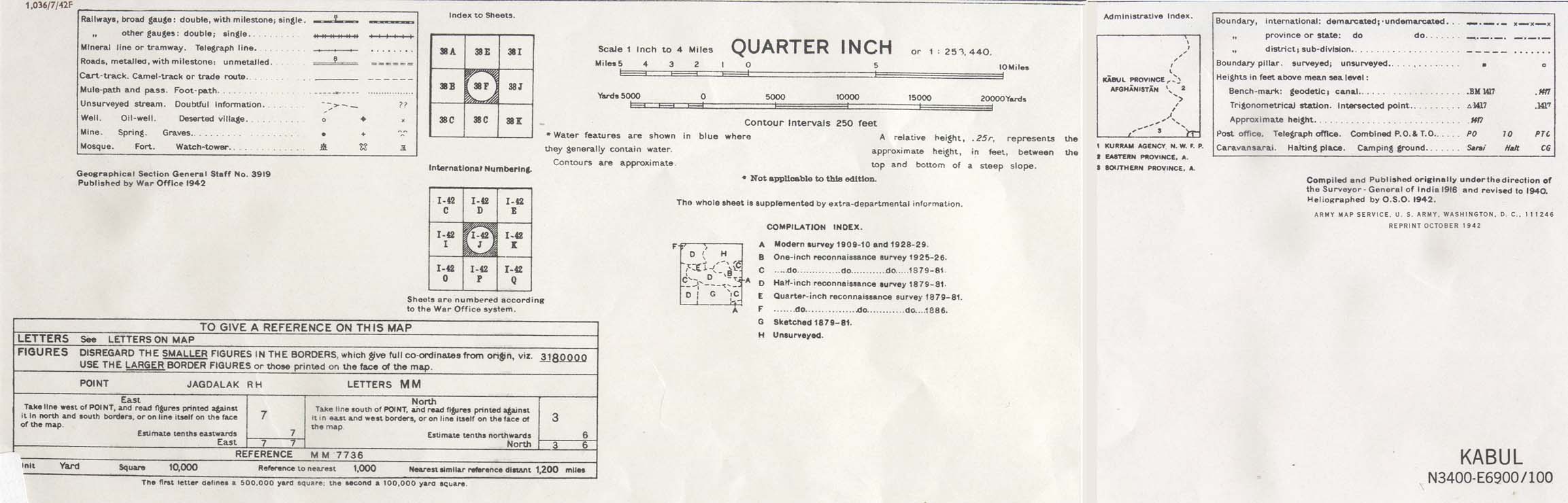
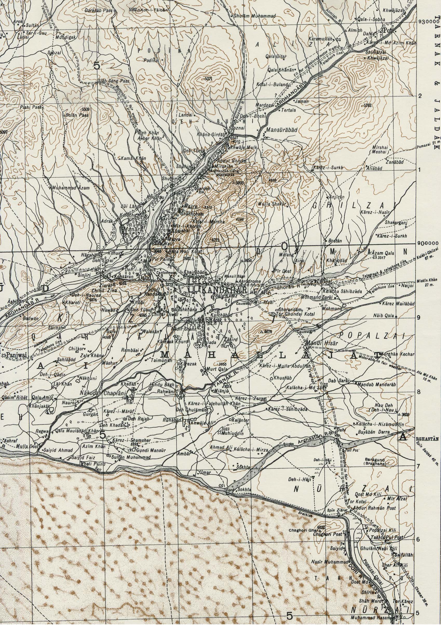
- Kabul Area, Afghanistan 1942 (810K)
- Portion of sheet I-42 J Kabul. Original scale 1:253,440 Compiled and published originally
under the direction of the Surveyor-General of India 1916 and Revised to 1940. Published by the War Office, 1942 and reprinted by the
U.S. Army Map Service October 1942. map key and scale (71K)
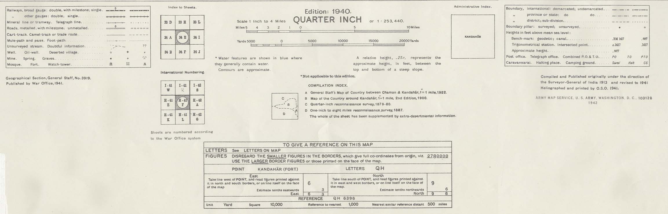
- Kandahar Area, Afghanistan 1942 (910K)
- Portion of sheet H-41 F Kandahar. Original scale 1:253,440 Compiled and published originally
under the direction of the Surveyor-General of India 1913 and Revised to 1941. Published by the War Office, 1942 and reprinted by the
U.S. Army Map Service October 1942. map key and scale (147K)
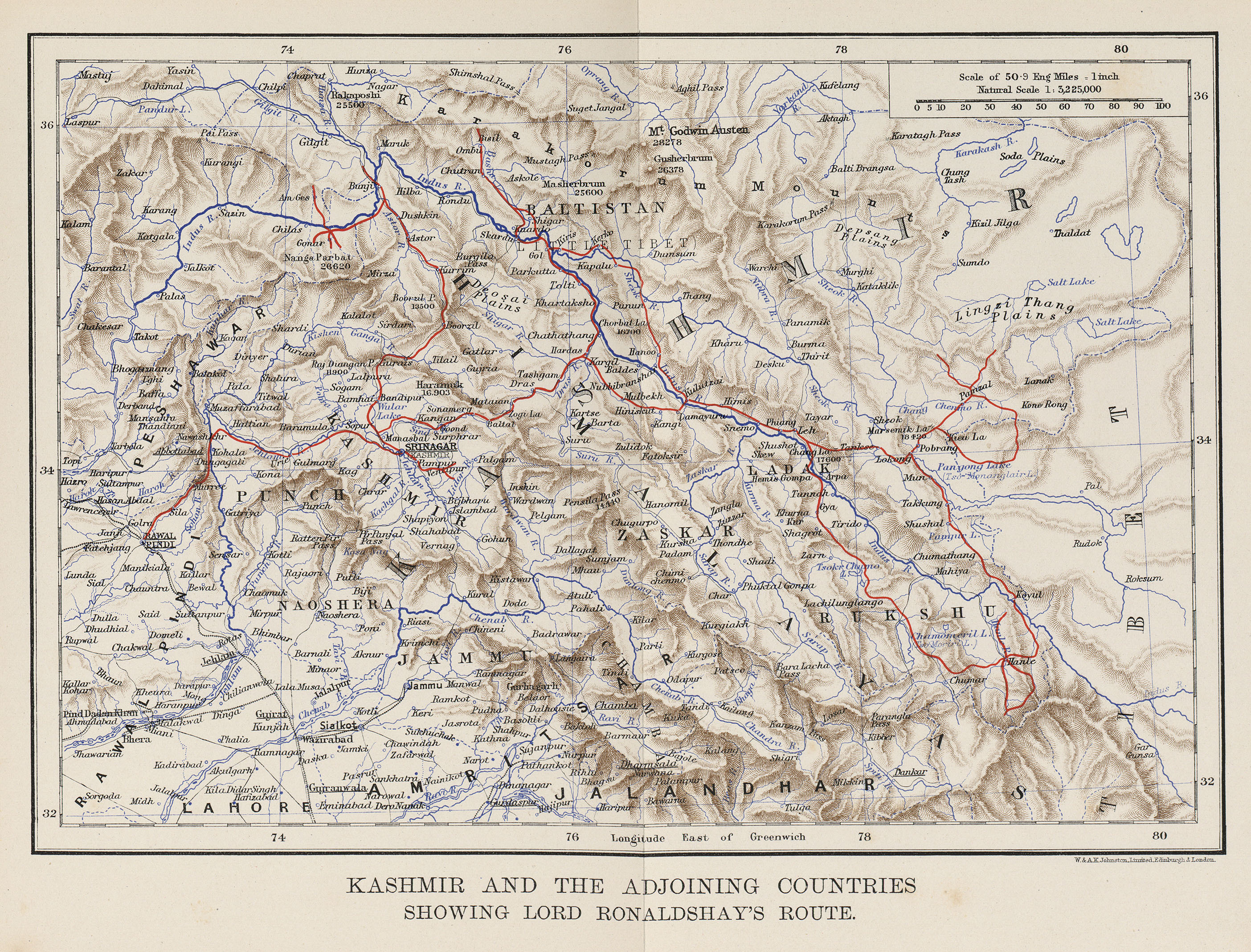
- Kashmir 1902 (2.3MB)
- "Kashmir and the Adjoining Countries Showing Lord Ronaldshay's Route" from Sport and Politics Under an Eastern Sky, William Blackwood and Sons, 1902.
- Kurrachee Harbour [Karachi Harbor] (392K)
- A Dictionary, Practical, Theoretical, and Historical of Commerce and Commercial Navigation, by J.R. M'Culloch. 1882.
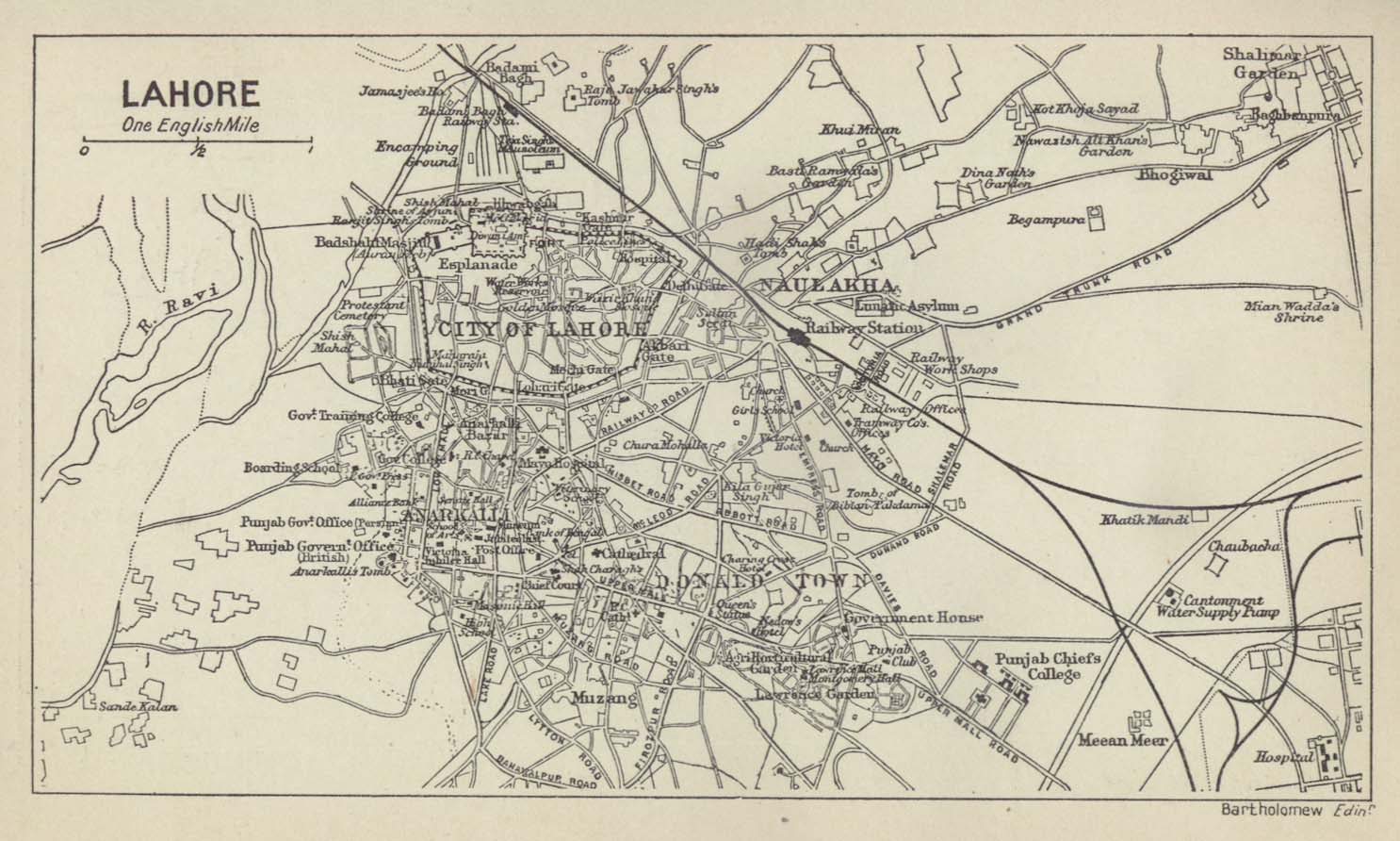
- Lahore 1912
- From A Literary and Historical Atlas of Asia by J.G. Bartholomew. J.M. Dent and Sons, Ltd. 1912.
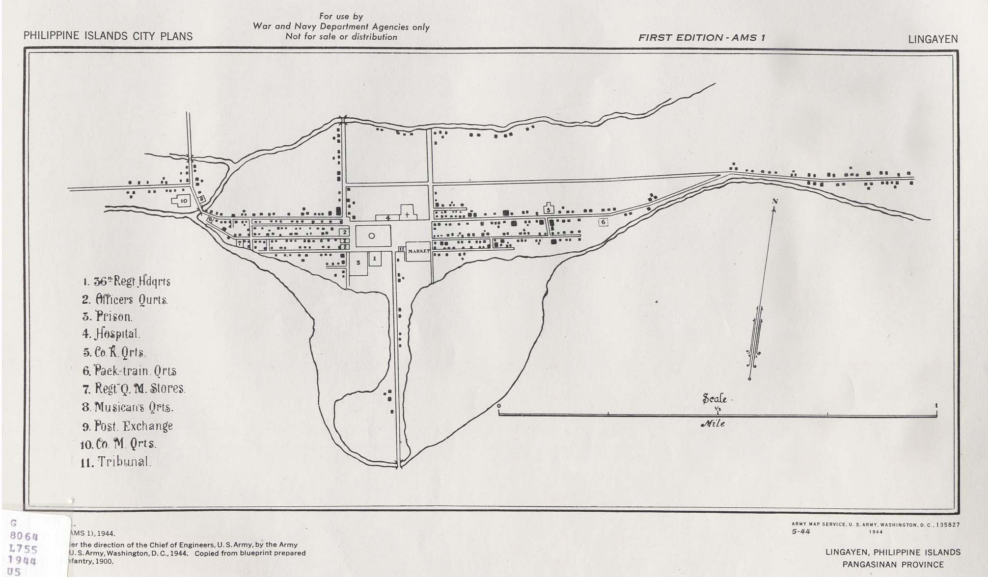
- Lingayen, Philippines 1944 (175K)
- Published by U.S. Army Map Service, 1944.
- Malacca [Melaka] 1854 (563K)
- "British Territory of Malacca" from An Atlas of the Southern Part of India. Pharoah and Co., Madras 1854.
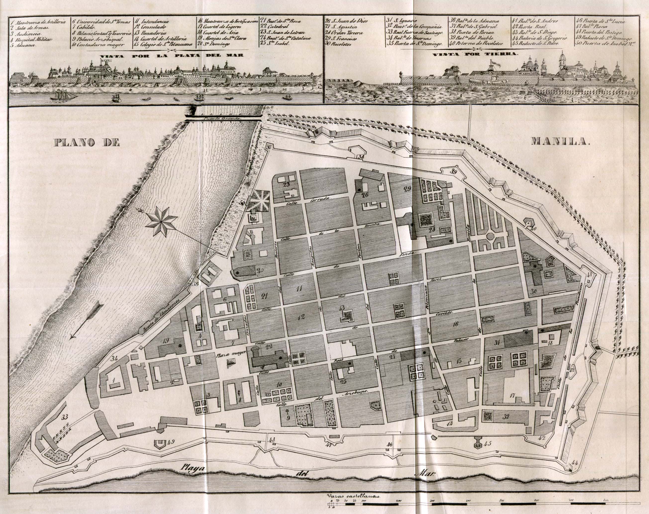
- Manila 1851 (851K)
- Diccionario Geografico-Estadistico-Historico De Las Islas Filipinas, Madrid 1851.
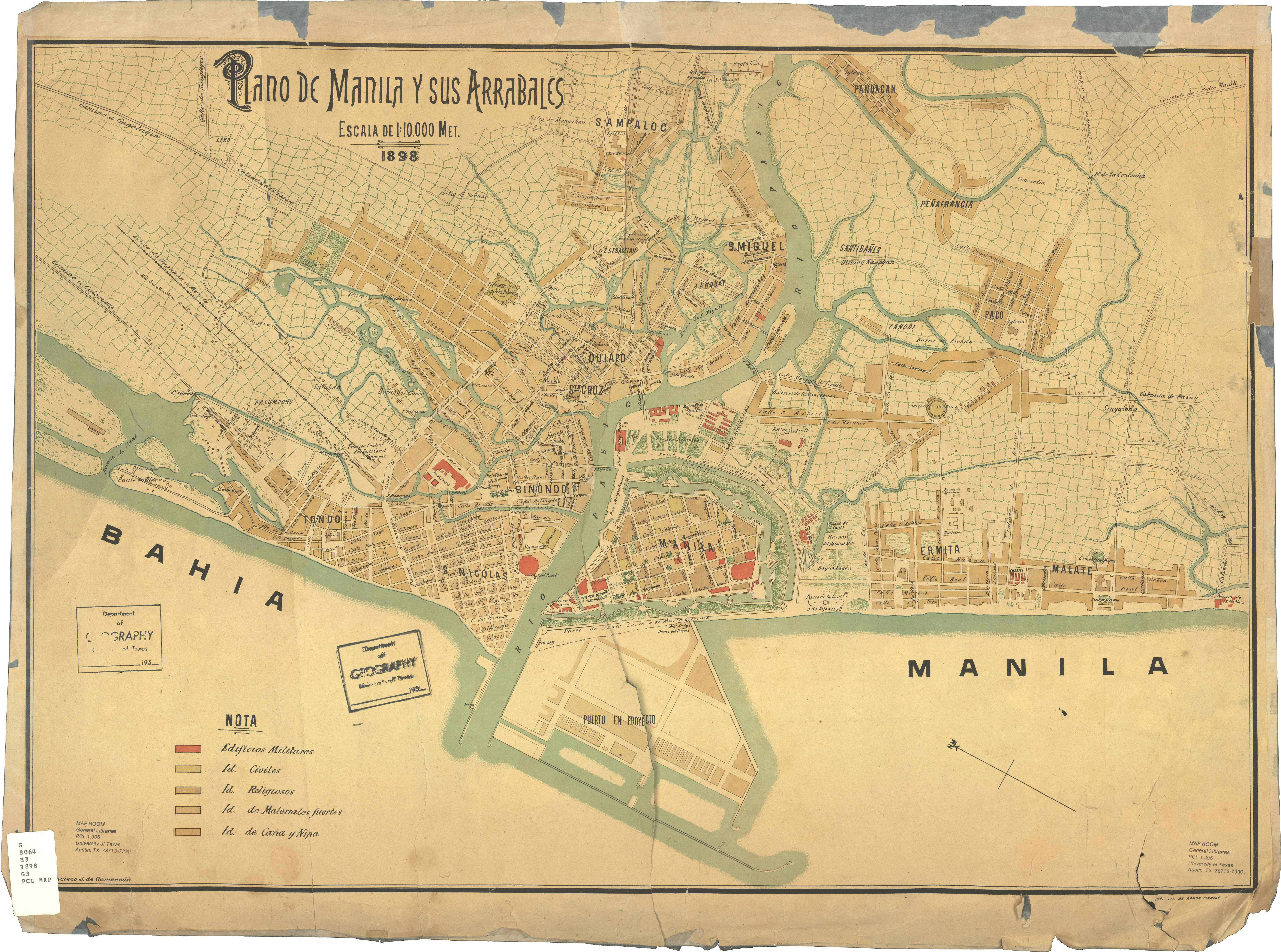
- Manila 1898 (3.8MB)
- Plano de Manila y sus Arrables, Francisco J. de Gamoneda ; imp. lit. de Ramon Montes, original scale 1:10,000, 1898.
- The Mongol Dominions, 1300-1405 (410K)
- From The Historical Atlas by William R. Shepherd, 1923.
- Nederlandisch-Indie [Netherlands Indies] circa 1893
- "Kaart van Nederlandisch-Indie naar oorspronkelijke teekening van H. Ph. Th. Witkamp", J.H. deBussy, Amsterdam, ca. 1893. Original scale of main map 1:5,000,000 (3.3 MB)
- New Encylopedic Atlas and Gazetter of the World 1867
- Maps from the New Encylopedic Atlas and Gazetter of the World by William Patte and James E. Homans: P.F. Collier, New York, 1911
- Oriental Empires about 600 B.C. (146K)
- From The Historical Atlas by William R. Shepherd, 1923.
- Persia and Afghanistan 1856 (1.4MB)
- "Map to Illustrate the Travels of General Ferrier in Persia and Afghanistan" from Caravan Journeys and Wanderings in Persia, Afghanistan, Turkistan, and Beloochistan; with Historical Notices of the Countries Lying Between Russia and India by Joseph Pierre Ferrier. Second Edition 1857.
- Persian Empire about 500 B.C. (134K)
- From The Historical Atlas by William R. Shepherd, 1923.
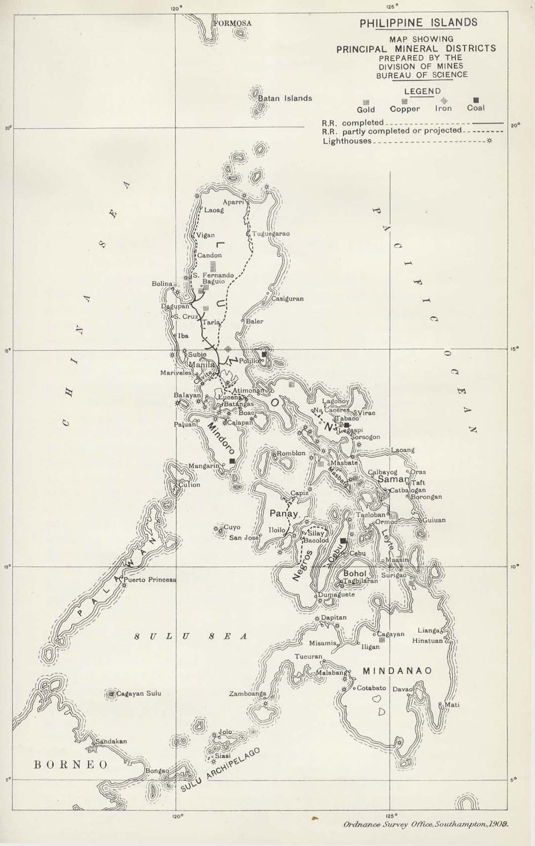
- Philippine Islands 1909 (192K)
- "Philippine Islands Map Showing Principal Mineral Districts" from Diplomatic and Consular Reports; Annual 4369 - 4387, 1908 Vol. 7; edited at the Foreign Office and the Board of Trade. London 1909.
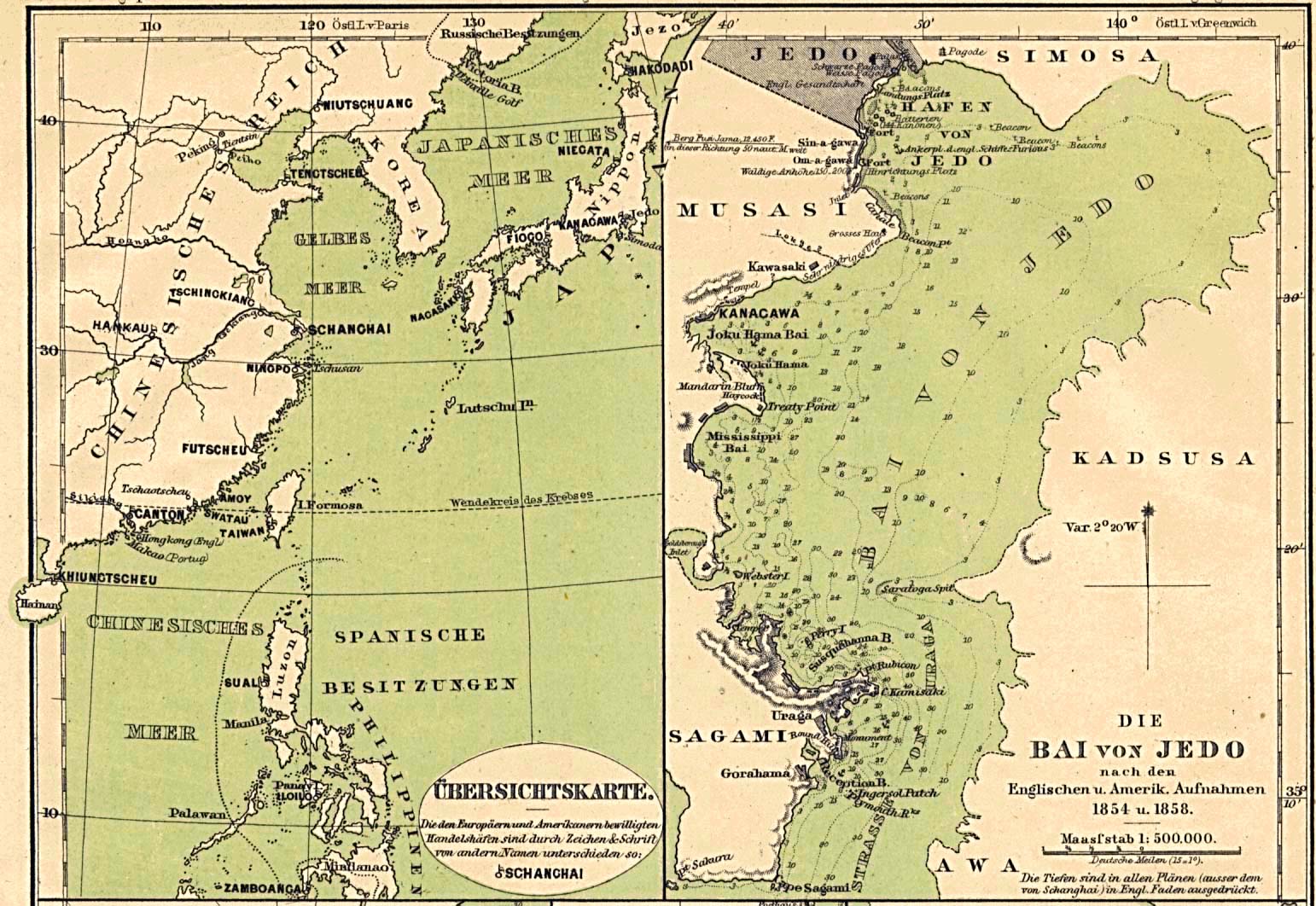
- Ports in China, Japan and the Philippines 1860 Part I (335K)
- "Übersichtskarte" (overview map) and "Die Bai von Jedo" (Jedo Bay map) [Tokyo/yokohama area] From Mittheilungen aus Justus Perthes' Geographischer Anstalt uber Wichtige Neue Erforschungen auf dem Gesammtgebiete der Geographie von Dr. A. Petermann. Volume 6, 1860.
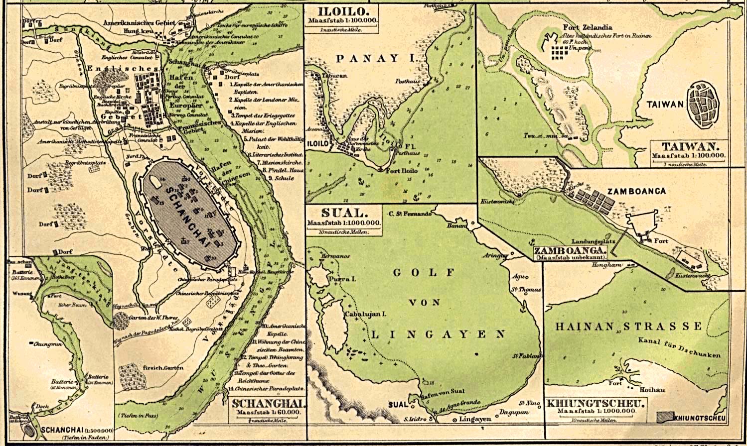
- Ports in China, Japan and the Philippines 1860 Part II (325K)
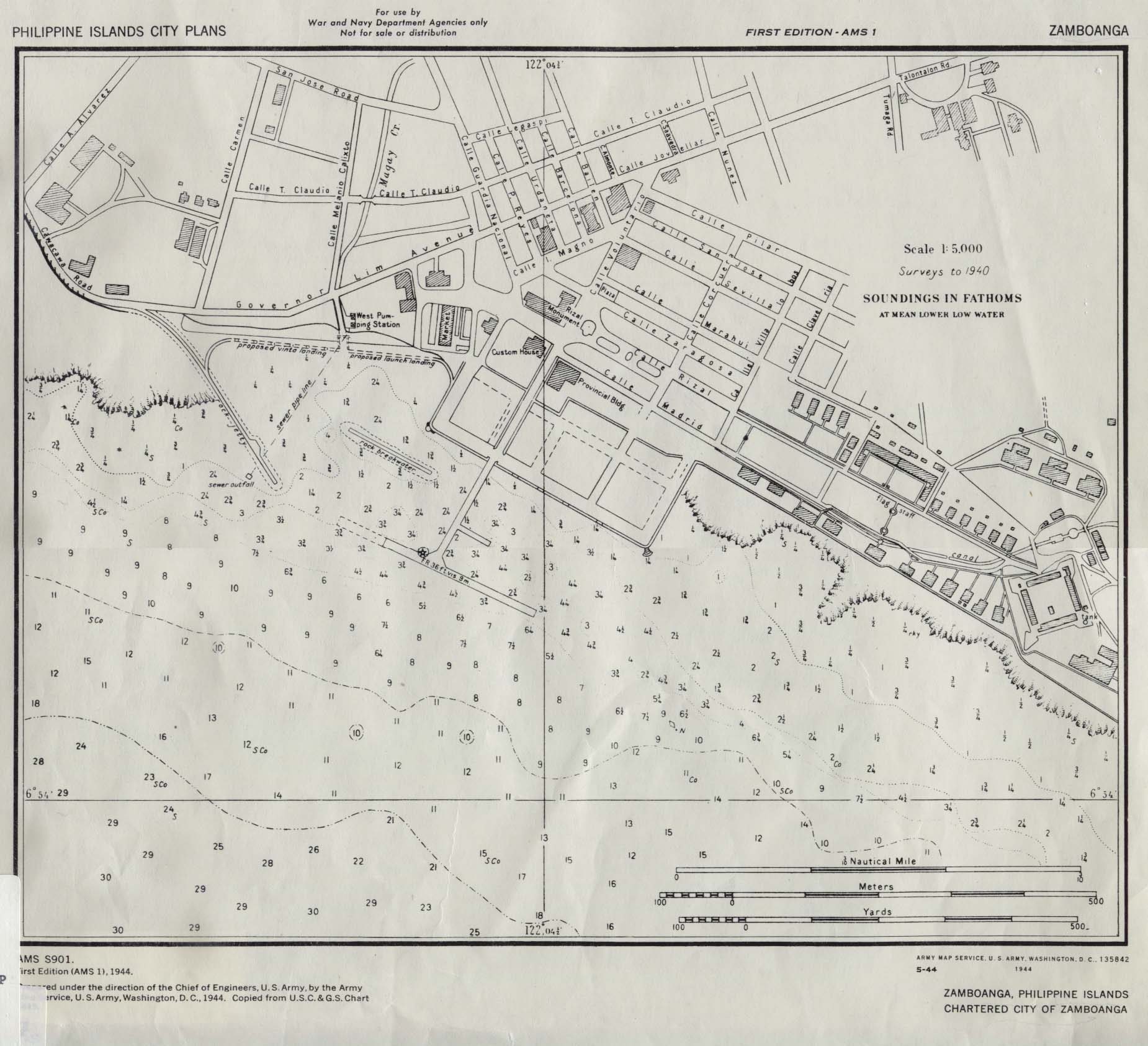
- Plans of Schanghai [Shanghai, China], Iloilo [Philippines], Sual [Port Sual, Philippines], Taiwan [now Tainan, Taiwan], Zamboanga [Philippines], Khiungtscheu [Kiungshan/ch'iung-Shan, China] From Mittheilungen aus Justus Perthes' Geographischer Anstalt uber Wichtige Neue Erforschungen auf dem Gesammtgebiete der Geographie von Dr. A. Petermann. Volume 6, 1860.
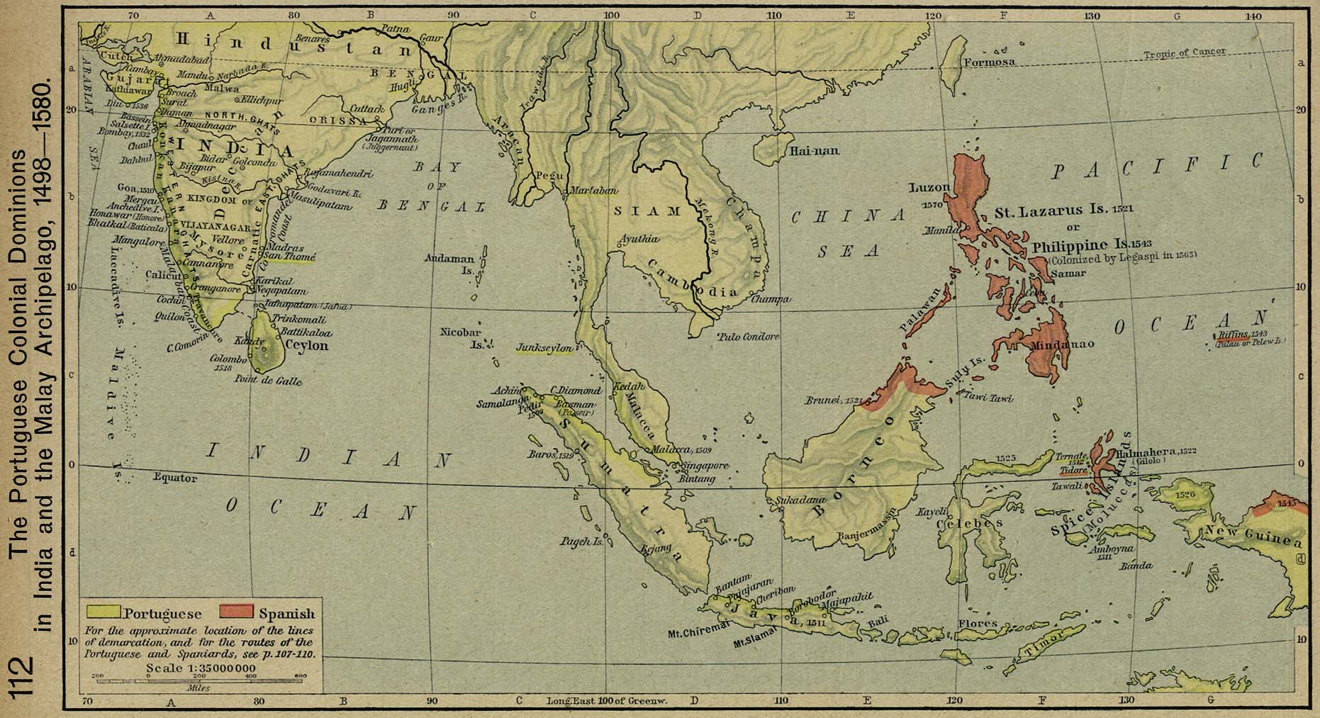
- The Portuguese Colonial Dominions in India and the Malay Archipelago, 1498-1580 (295K)
- From The Historical Atlas by William R. Shepherd, 1926.
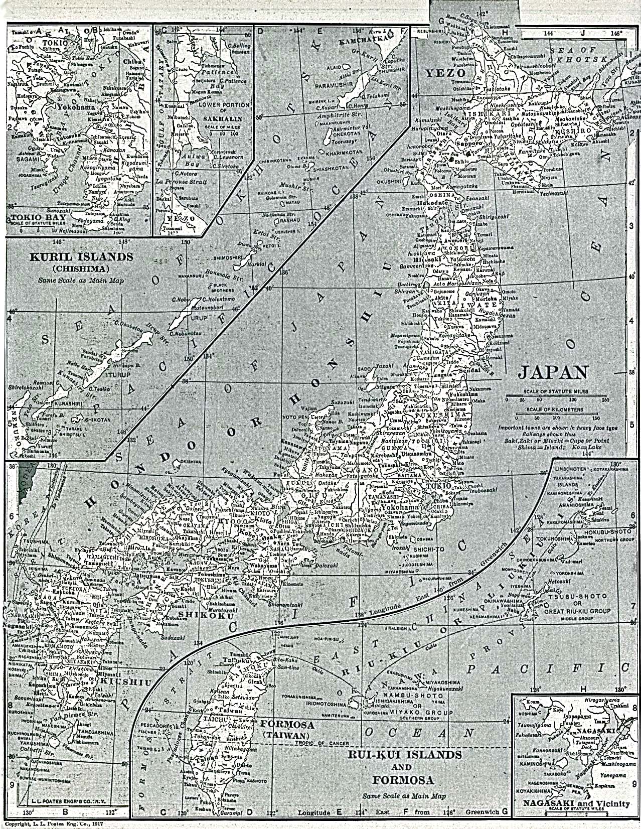
- Principal Cities and Towns of Japan 1917 (817K)
- "Japan" with inset maps "Kuril and Rui-Kui Islands" from The New Encyclopedic Atlas & Gazetteer of the World. 1917.
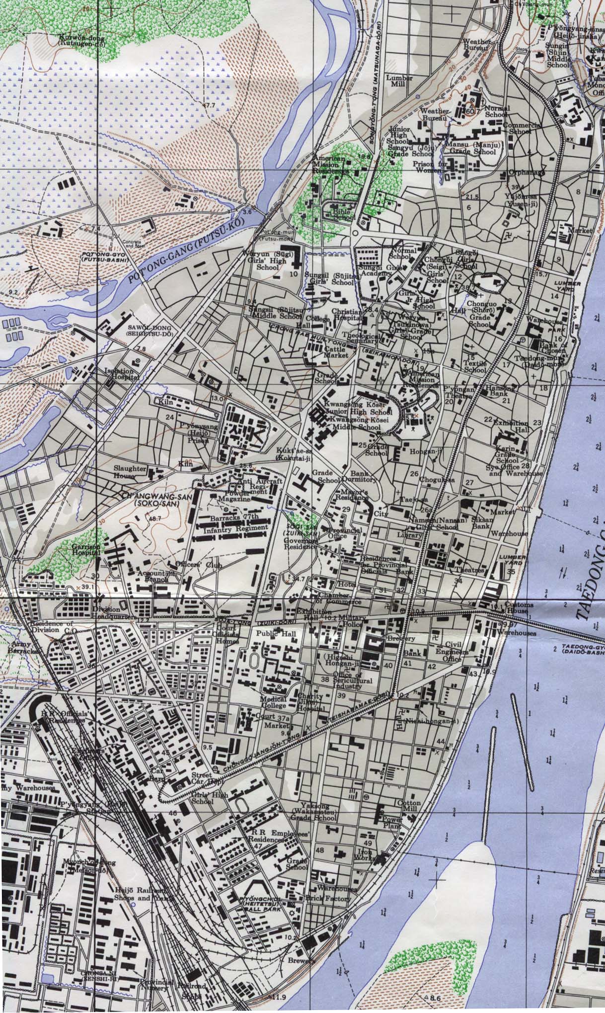
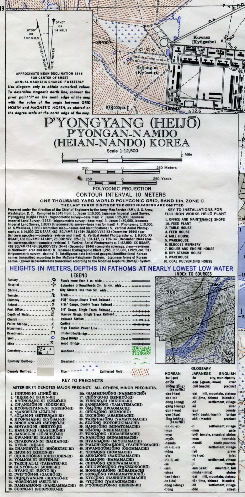
- Pyongyang, North Korea 1946 (549K) Map Key (277K)
- Original scale 1:12,500. Portion of Army Map Service L951 1946.
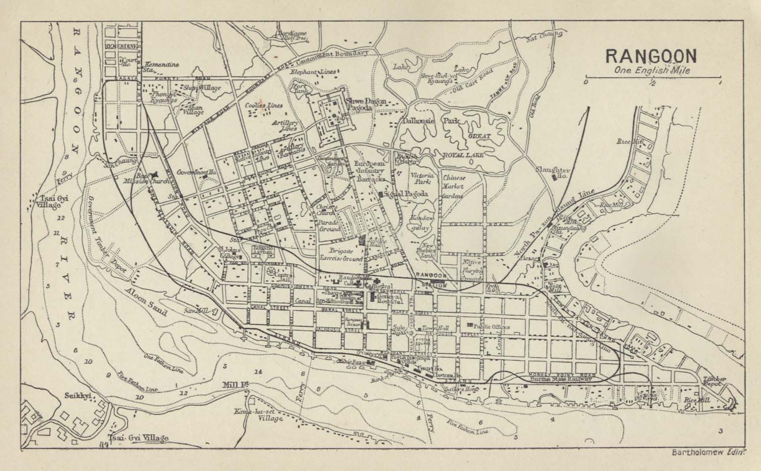
- Rangoon 1912
- From A Literary and Historical Atlas of Asia by J.G. Bartholomew. J.M. Dent and Sons, Ltd. 1912.
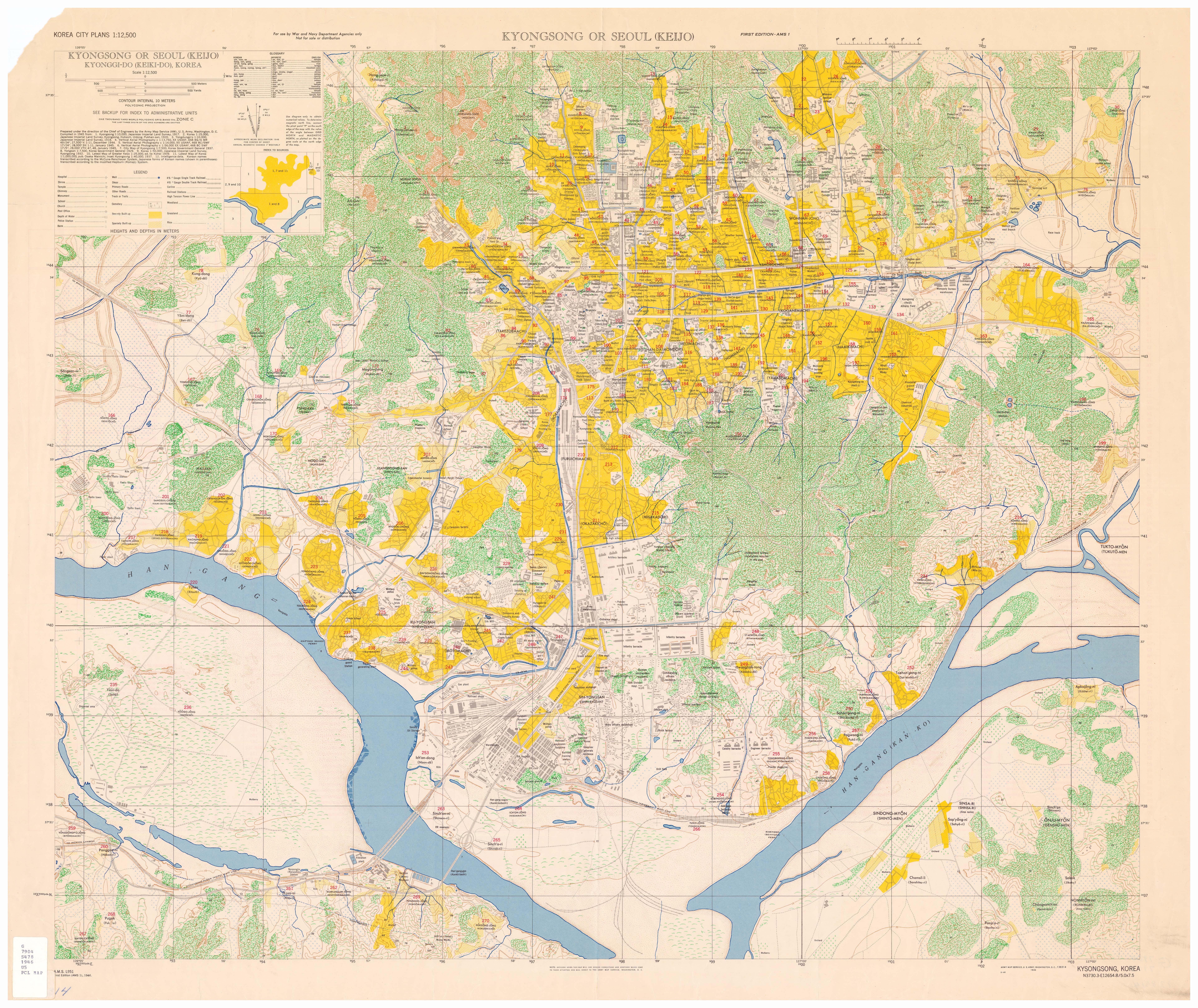
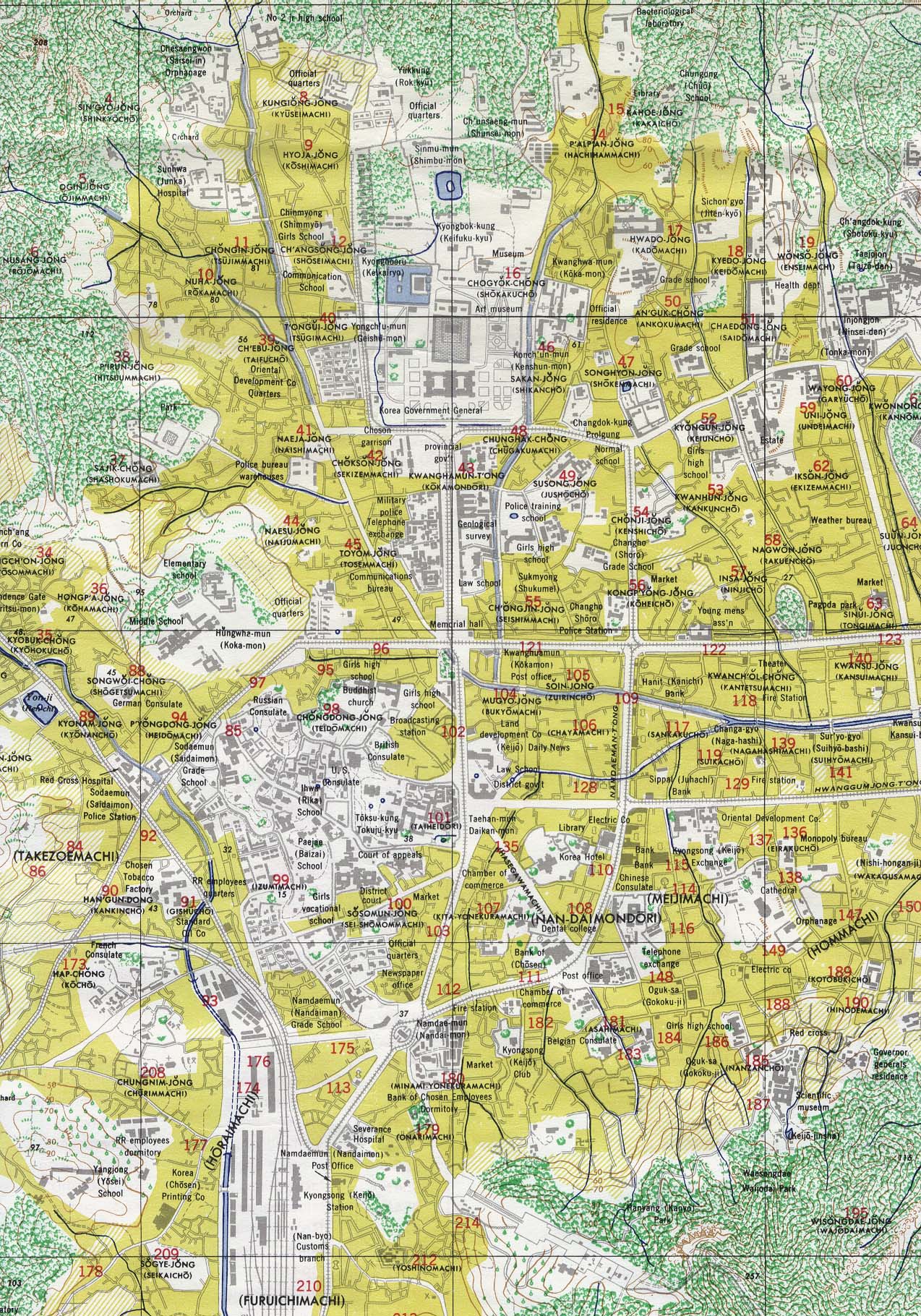
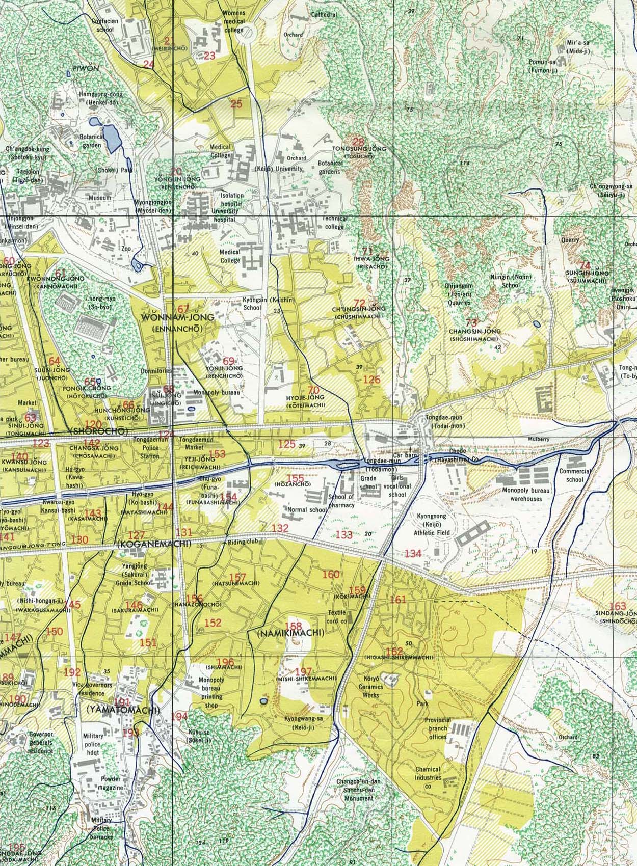
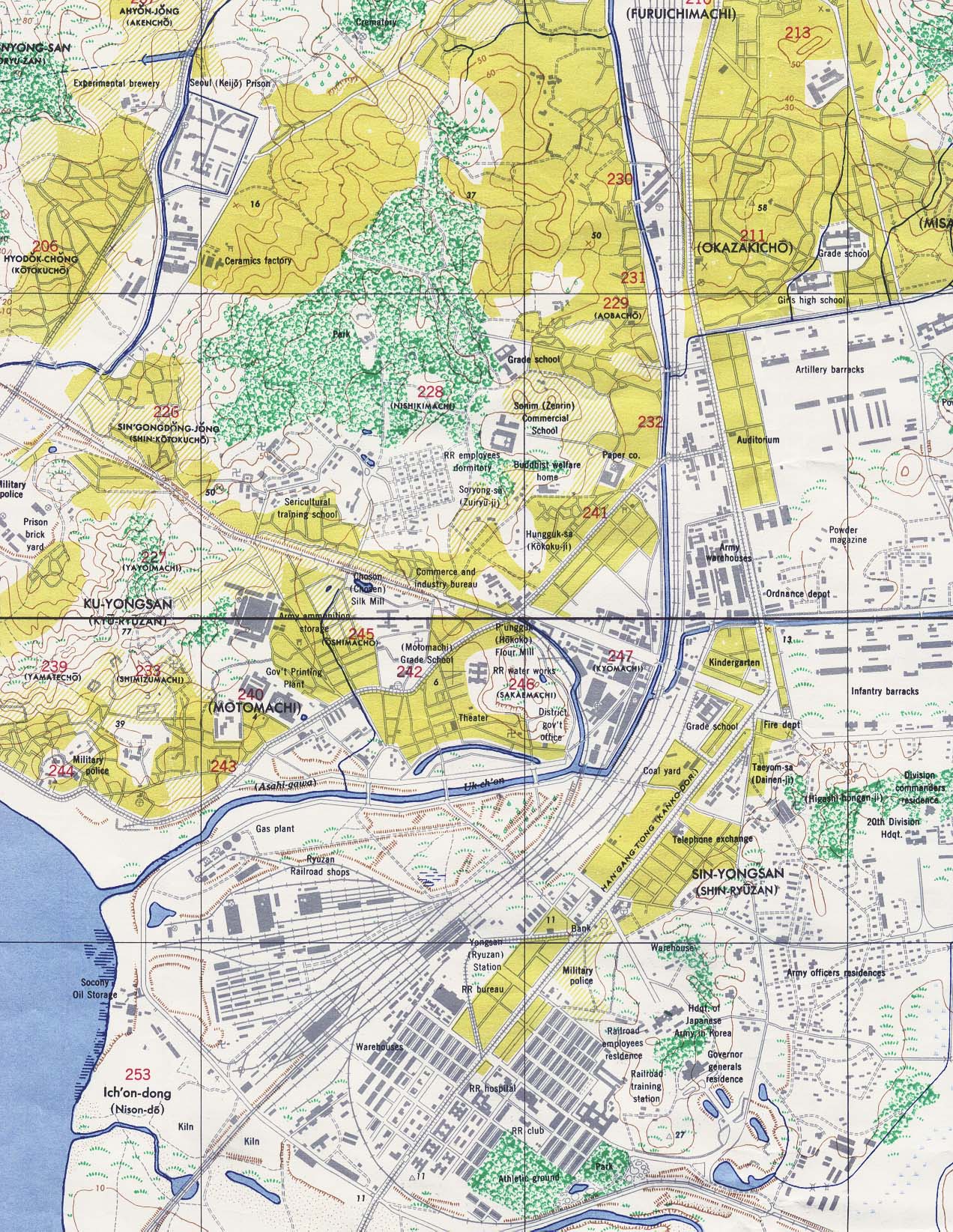
- Seoul 1946 (7.6MB)
- Central (628K), East (509K), South (555K), or Entire Map (7.6MB) from "Kyongsong or Seoul (Keijo) Kyonggi-do (Keiki-do), Korea", original scale 1:12,500 U.S. Army Map Service, 1946.
- Shanghai Maps see China Historical Maps Page
- Soerabaja [Surabaya] 1897 (452K)
- From Guide to the Dutch East Indies by Dr. J.F. van Bemmelen and G.B. Hoover, Luzac & Co, London 1897.
- [Taiwan] Formosa 1896 (439K)
- From the Scottish Geographical Magazine. Published by the Royal Scottish Geographical Society and edited by James Geikie and W.A. Taylor. Volume XII, 1896.
- [Tibet] Grand Monastery of Tashi-Lhunpo 1902 (903k)
- "The Grand Monastery of Tashi-Lhunpo" from Journey to Lhasa and Central Tibet by Sarat Chandra Das, 1902.
- [Tibet] Grand Temple at Lhasa 1902 (581k)
- "Cho-Khang, The Grand Temple of Buddha at Lhasa" from Journey to Lhasa and Central Tibet by Sarat Chandra Das, 1902.
- [Tibet] Shigatse 1902 (581k)
- "The Jong or Fort of Shigatse" from Journey to Lhasa and Central Tibet by Sarat Chandra Das, 1902.
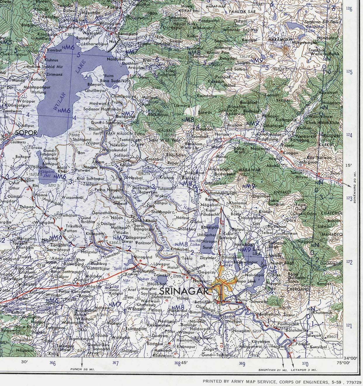
- Srinagar Area 1959 (520K)
- Portion of sheet NI 43-6 Srinagar. Edition May 1959. Original scale 1:250,000 Compiled in 1954 from Survey of India. Published by the U.S. Army Map Service, July 1959 Not for navigational use
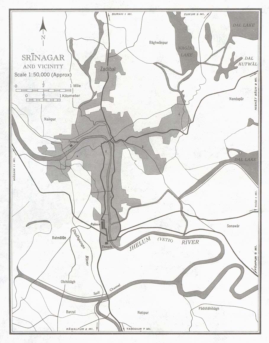
- Srinagar and Vicinty (town plan) 1959 (146K)
- Portion of sheet NI 43-6 Srinagar. Edition May 1959. Original scale 1:50,000 Compiled in 1954 from Survey of India. Published by the U.S. Army Map Service, July 1959 Not for navigational use
- [Tokyo] Edo 1844-1848
- [Tokyo] Jedo Bay, Ports in China, Japan and the Philippines 1860 Part I (335K)
- Ports Location Map and Plan of Jedo Bay, [Tokyo/yokohama, Japan] From Mittheilungen aus Justus Perthes' Geographischer Anstalt uber Wichtige Neue Erforschungen auf dem Gesammtgebiete der Geographie von Dr. A. Petermann. Volume 6, 1860.
- [Tokyo] Tokio Region - East 1879 (1.3MB)
- A portion of "Die Umgegend der Bai von Tokio und des Vulkans Fuji-No-Yama" from Mittheilungen aus Justus Perthes' Geographischer Anstalt uber Wichtige Neue Erforschungen auf dem Gesammtgebiete der Geographie von Dr. A. Petermann. Volume 25, tafel 19, 1879
- [Tokyo] Tokio Region - West 1879 (968K)
- A portion of "Die Umgegend der Bai von Tokio und des Vulkans Fuji-No-Yama" from Mittheilungen aus Justus Perthes' Geographischer Anstalt uber Wichtige Neue Erforschungen auf dem Gesammtgebiete der Geographie von Dr. A. Petermann. Volume 25, tafel 19, 1879
- [Tokyo] Yedo Bay Hydrographic Chart 1879 (968K)
- "Hydrographische Skizze der Edene von Yedo" from Mittheilungen aus Justus Perthes' Geographischer Anstalt uber Wichtige Neue Erforschungen auf dem Gesammtgebiete der Geographie von Dr. A. Petermann. Volume 25, Tafel 7, 1879
- Treaty Ports of China and Japan 1867
- Maps from the Treaty Ports of China and Japan by William Frederick Mayers, NB Dennys, Charles King; London: Trubner and CO., 1867
- World War II Maps of the Asia-Pacific Theater (30 Maps)
- Zamboanga, Philippines 1944 (297K)
- Published by U.S. Army Map Service, 1944.
![Candahar [Kandahar], Battle at](battle_candahar_1892.jpg)
![[Ambon, Netherlands East Indies] Tan Toey Prisoners of War Camp 1943](ambon_1943.jpg)
![Batavia [Jakarta] 1897](batavia_1897.jpg)
![Ceylon [Sri Lanka] 1914](ceylon_1914.jpg)
![Formosa [Taiwan] 1896](formosa_1896.jpg)
![[Japan - Aonohara Military Training Fields] 1900](http://maps.lib.utexas.edu/maps/historical/japan_aonohara_1900.jpg)
![[Korea] Chosen 1911](http://maps.lib.utexas.edu/maps/historical/japan_chosen_1911.jpg)
![[Northern Honshu region of Japan] Hokuriku 1874 - 1](http://maps.lib.utexas.edu/maps/historical/japan_hokuriku_1_1874.jpg)
![[Northern Honshu region of Japan] Hokuriku 1874 - 2](http://maps.lib.utexas.edu/maps/historical/japan_hokuriku_2_1874.jpg)
![Kurrachee Harbour [Karachi Harbor]](kurrachee_harbour_1882.jpg)
![Malacca [Melaka] 1854](malacca_1854.jpg)
![Nederlandisch-Indie [Netherlands Indies] circa 1893](nederlandsch_indie_1893.jpg)
![Soerabaja [Surabaya] 1897](soerabaja_1897.jpg)
![[Tibet] Grand Monastery of Tashi-Lhunpo 1902](tashilhunpo_1902.jpg)
![[Tibet] Grand Temple at Lhasa 1902](chokhang_1902.jpg)
![[Tibet] Shigatse 1902](thejong_1902.jpg)
![[Tokyo] Tokio Region - East 1879](tokio_east_1879.jpg)
![[Tokyo] Tokio Region - West 1879](tokio_west_1879.jpg)
![[Tokyo] Yedo Bay Hydrographic Chart 1879](yedo_1879.jpg)