Perry-Castañeda Library
Map Collection
Historical Maps of the Americas
- United States Historical Maps
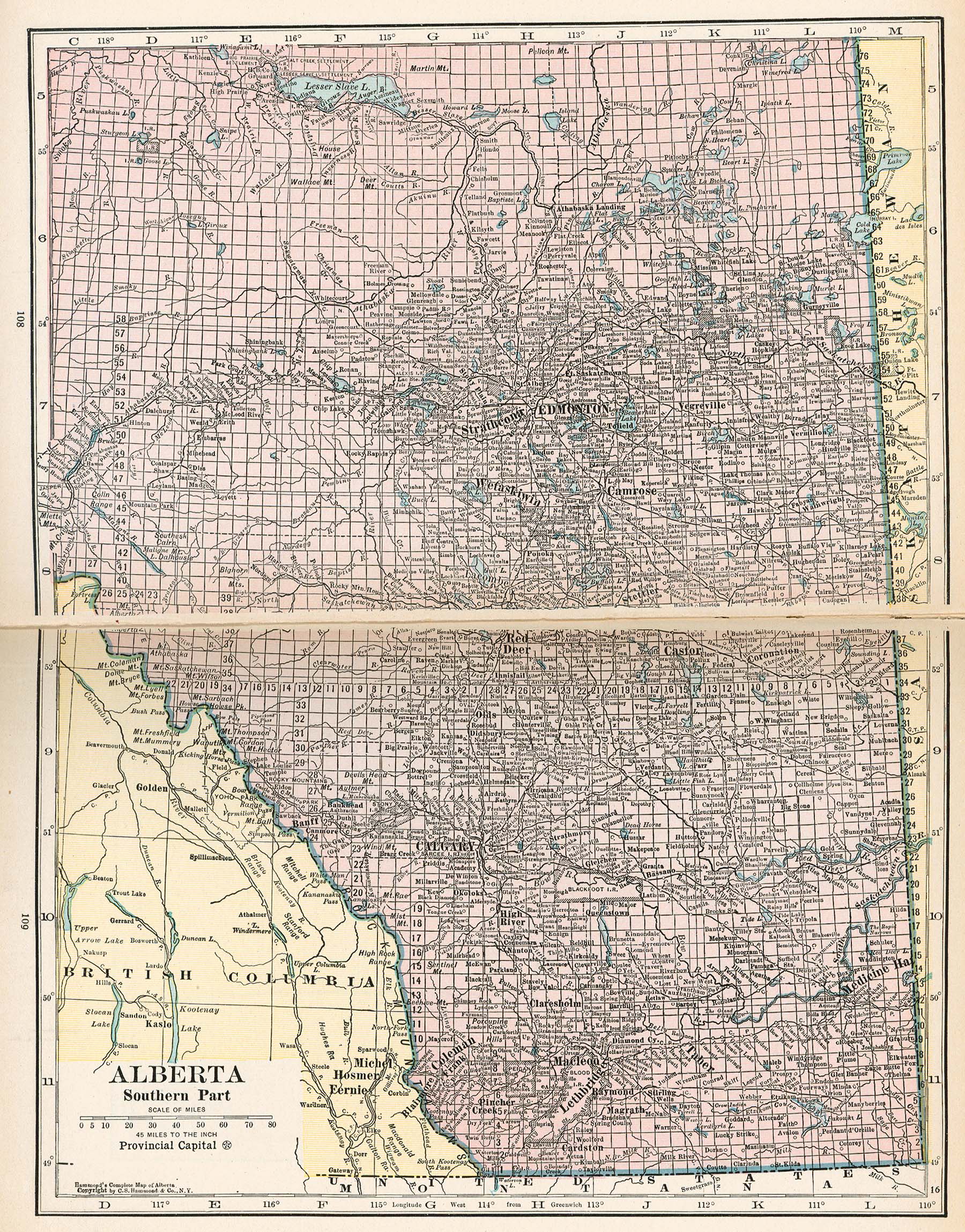
- Alberta 1921 (1105K)
- From Putnam's Handy Volume Atlas of the World. Published by G.P. Putnam's Sons, New York and London, 1921.
- Bahia (Bay of all Saints) 1882 [Brazil] (294K)
- A Dictionary, Practical, Theoretical, and Historical of Commerce and Commercial Navigation, by J.R. M'Culloch. 1882
- Anegada 1832 [British Virgin Islands] (692K)
- "Anegada with it's Reefs by R.H. Schomburgk" from The Journal of the Royal Geographical Society, Volume 2, 1832 to accompany "Remarks on Anegada. Communicated by Robert Hermann Schomburgk, Esq., Member of the Horticultural Society of Berlin"
- Brasile Orientale 1899 [Brazil] (925K)
- From Atlante Mondiale Hoepli di Geografia Moderna Fisica e Politica. Giovanni Roncagli, 1899.
- The British Colonies in North America, 1763-1775 (581K)
- Inset: Middle Colonies. From The Historical Atlas by William R. Shepherd, 1923.
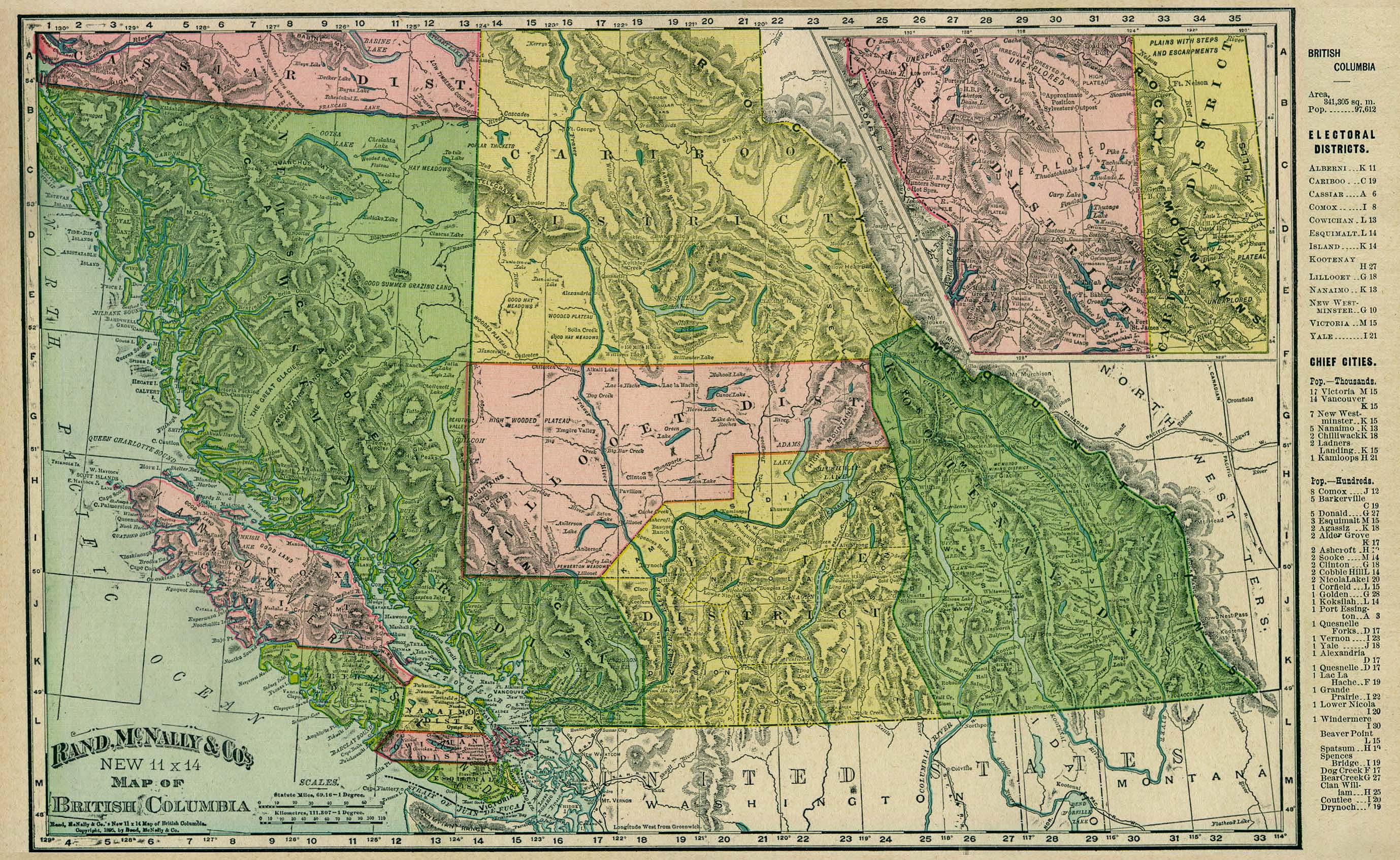
- British Columbia 1895 (1MB)
- From Rand, McNally & Co.'s Universal Atlas of The World. Edition 1896.
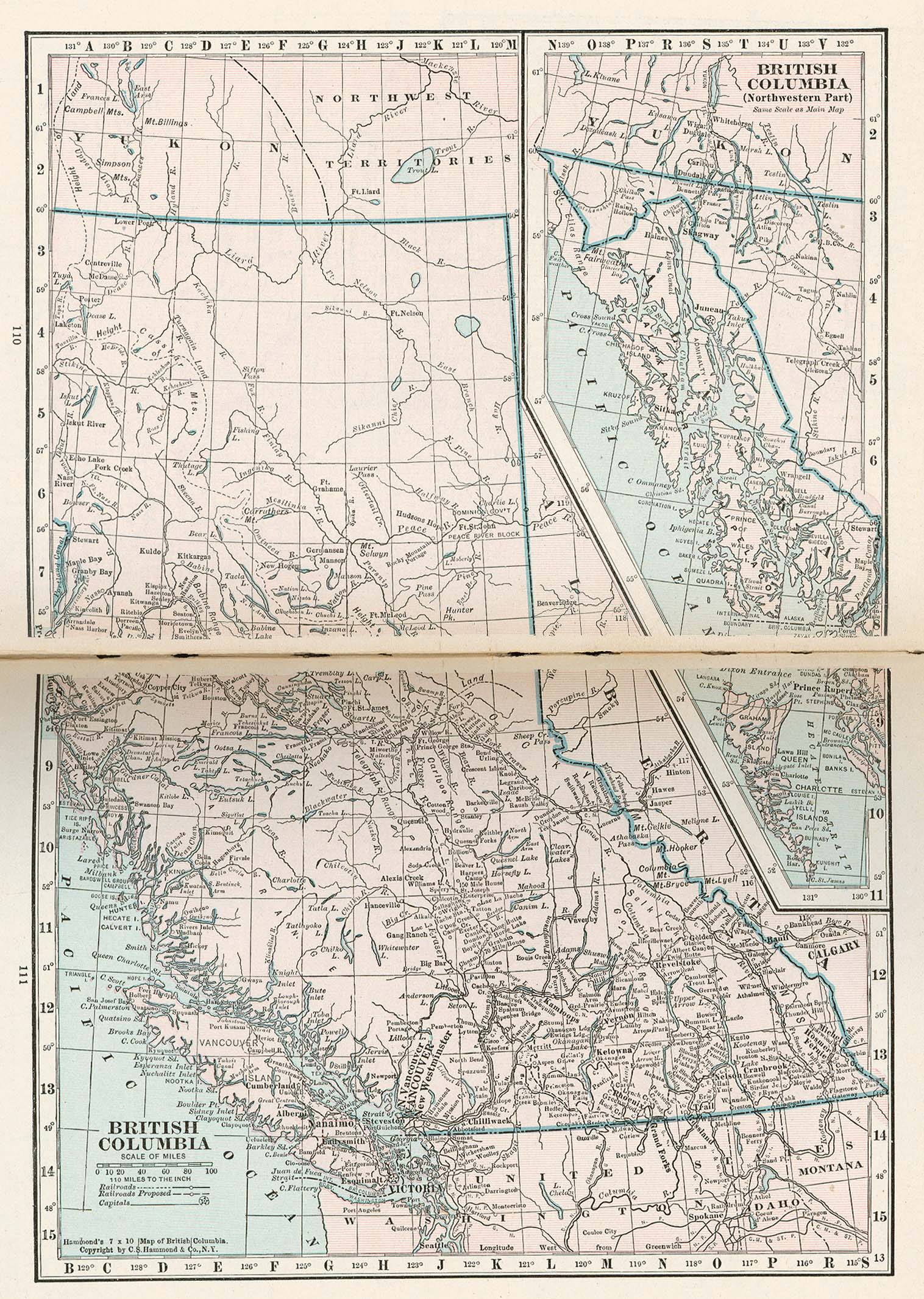
- British Columbia 1921 (687K)
- From Putnam's Handy Volume Atlas of the World. Published by G.P. Putnam's Sons, New York and London, 1921.
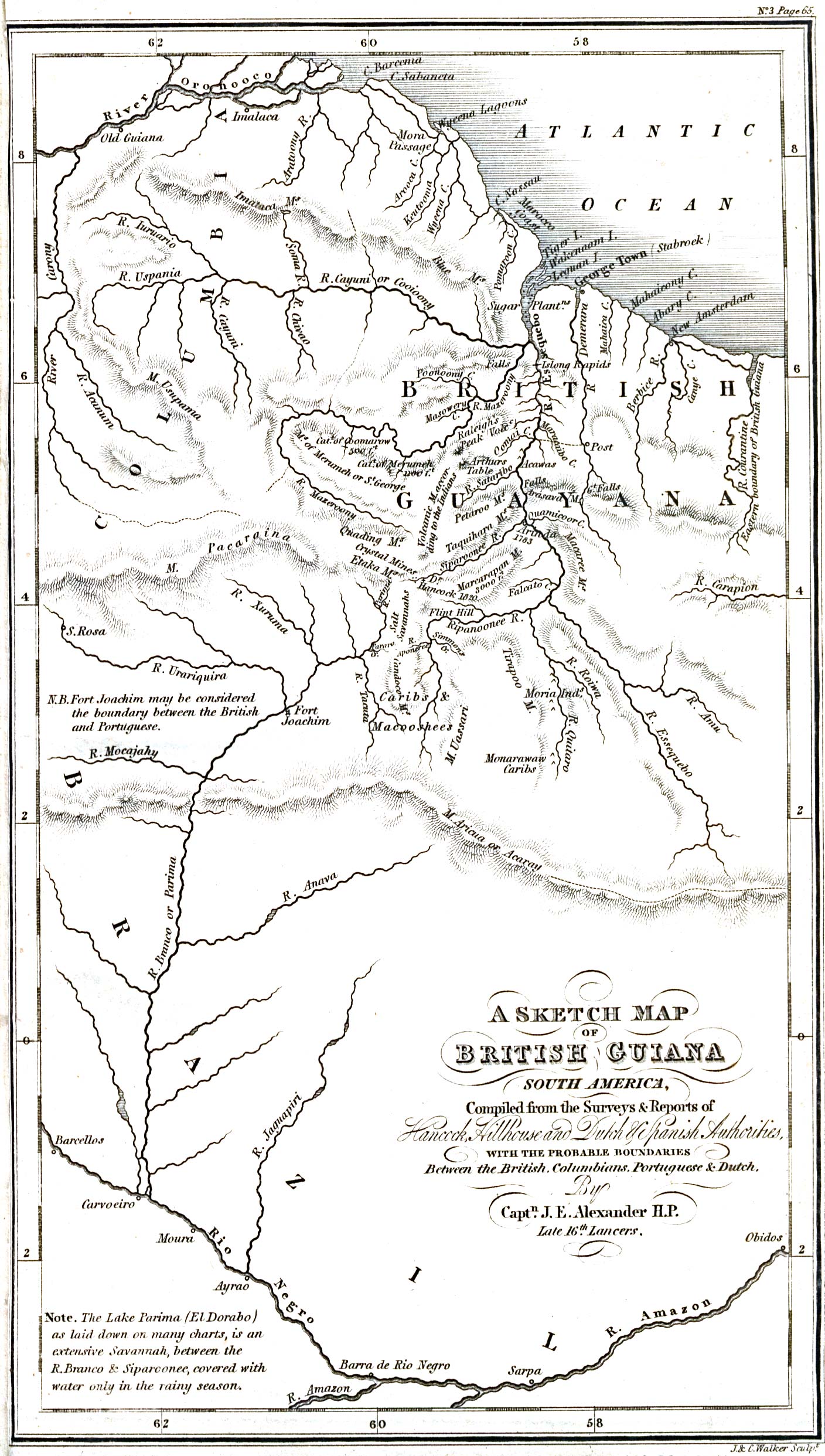
- British Guiana 1832 (635K)
- "A Sketch Map of British Guiana, South America, Compiled from the Surveys & Reports of Hancock, Hillhouse and Dutch & Spanish Authorities, with the probable boundaries Between the British, Columbians, Portuguese & Dutch, By Captain J.E. Alexander H.P. Late 16th Lancers" from The Journal of the Royal Geographical Society, Volume 2, 1832 to accompany "Notices of the Indians settled in the Interior of British Guiana. By William Hilhouse, Esq."
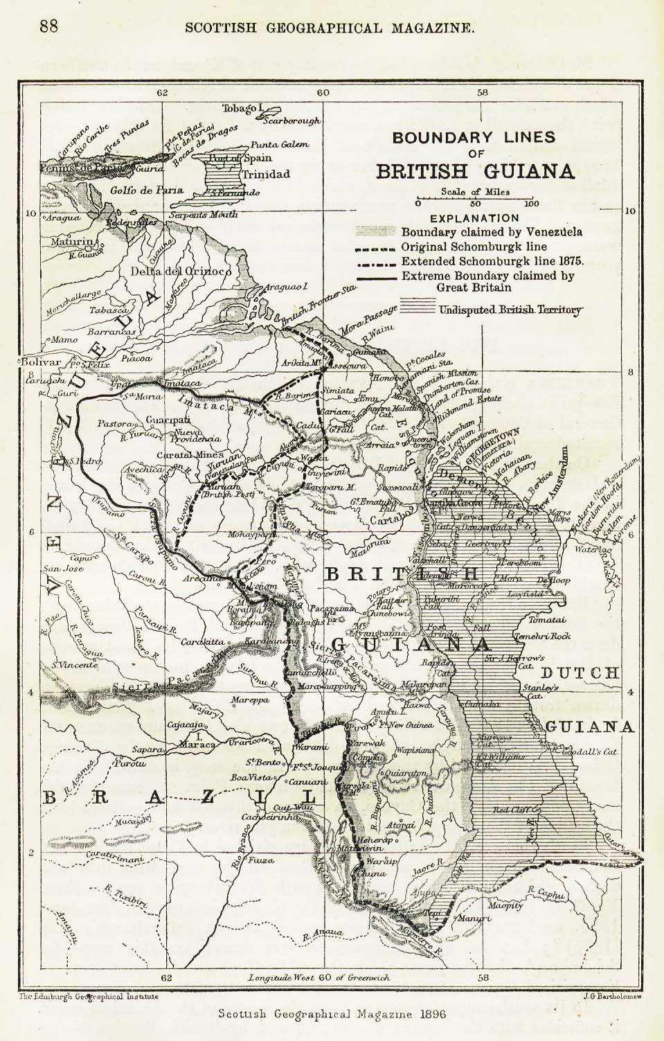
- British Guiana 1896 (304K)
- "Boundary Lines of British Guiana" from the Scottish Geographical Magazine. Published by the Royal Scottish Geographical Society and edited by James Geikie and W.A. Taylor. Volume XII, 1896.
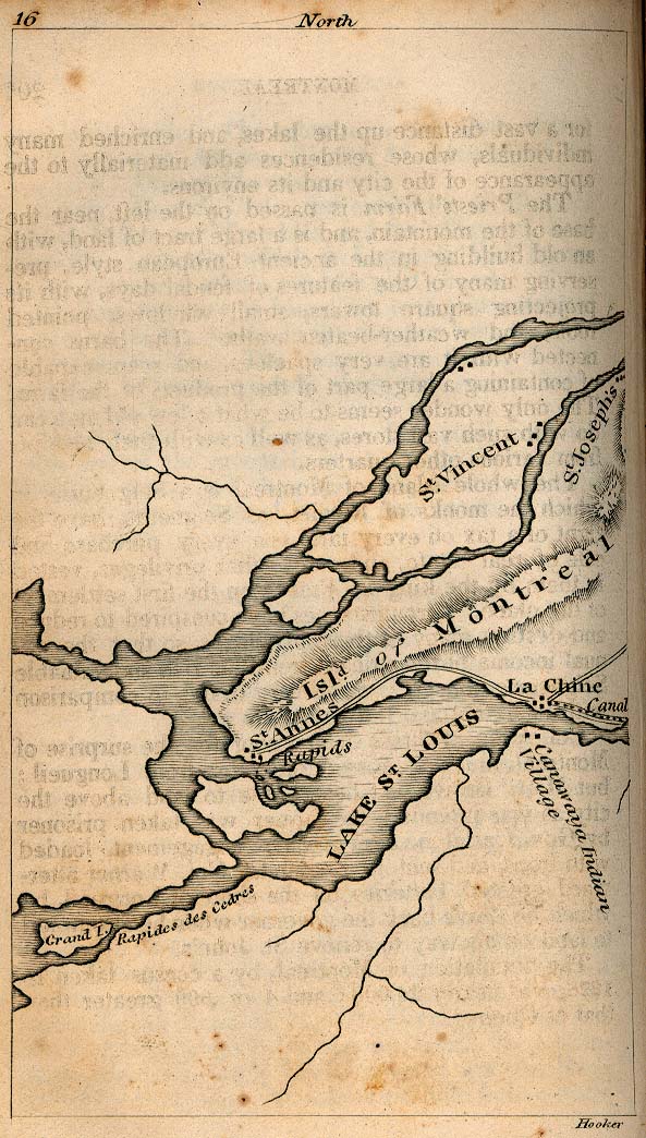
- Canada - Lower 1830 (148K)
- From The Northern Traveller, and Northern Tour; with the Routes to The Springs, Niagara, and Quebec, and the Coal Mines of Pennsylvania; also, the Tour of New-England. New York, 1830.
- Central America 1892 (839K)
- "Central America" from Americanized Encyclopaedia Britannica, Vol.1, Chicago 1892.
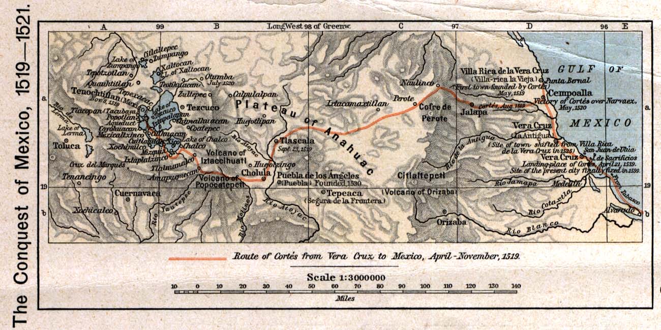
- The Conquest of Mexico, 1519 - 1521 (350K)
- From The Historical Atlas by William R. Shepherd, 1923.
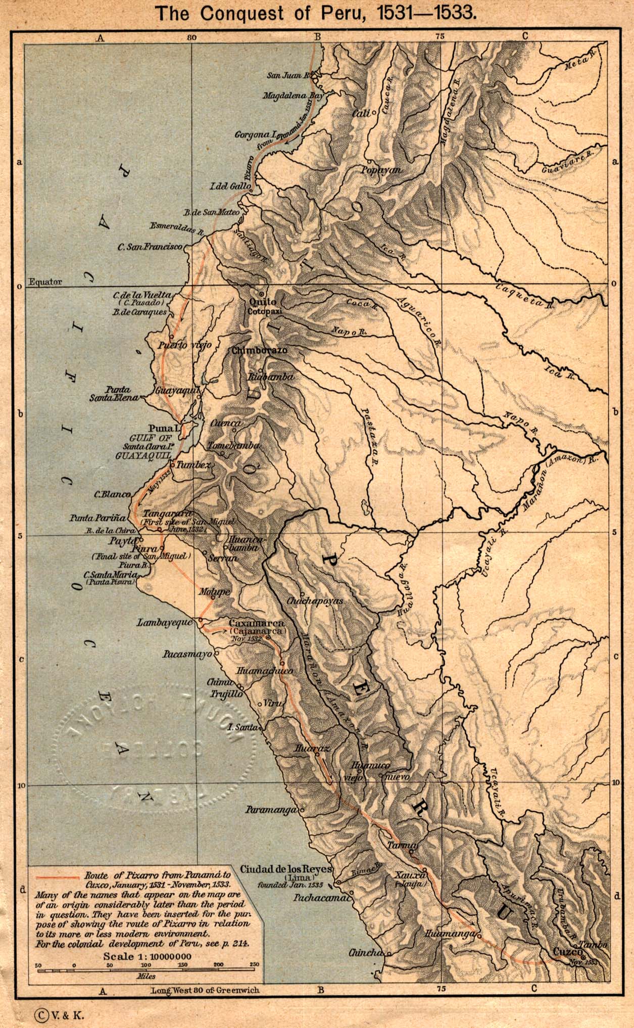
- The Conquest of Peru, 1531 - 1533 (431K)
- From The Historical Atlas by William R. Shepherd, 1923.
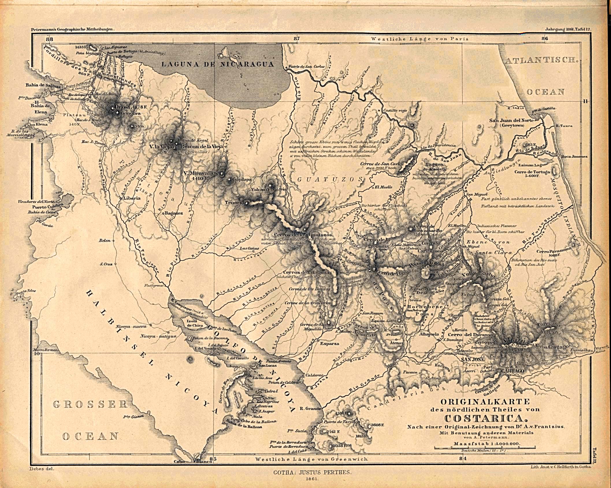
- Costa Rica - North 1861 (792K)
- "Originalkarte des nordlichen Theiles von Costarica" from Mittheilungen aus Justus Perthes' Geographischer Anstalt uber Wichtige Neue Erforschungen auf dem Gesammtgebiete der Geographie von Dr. A. Petermann. Volume 7, 1861.
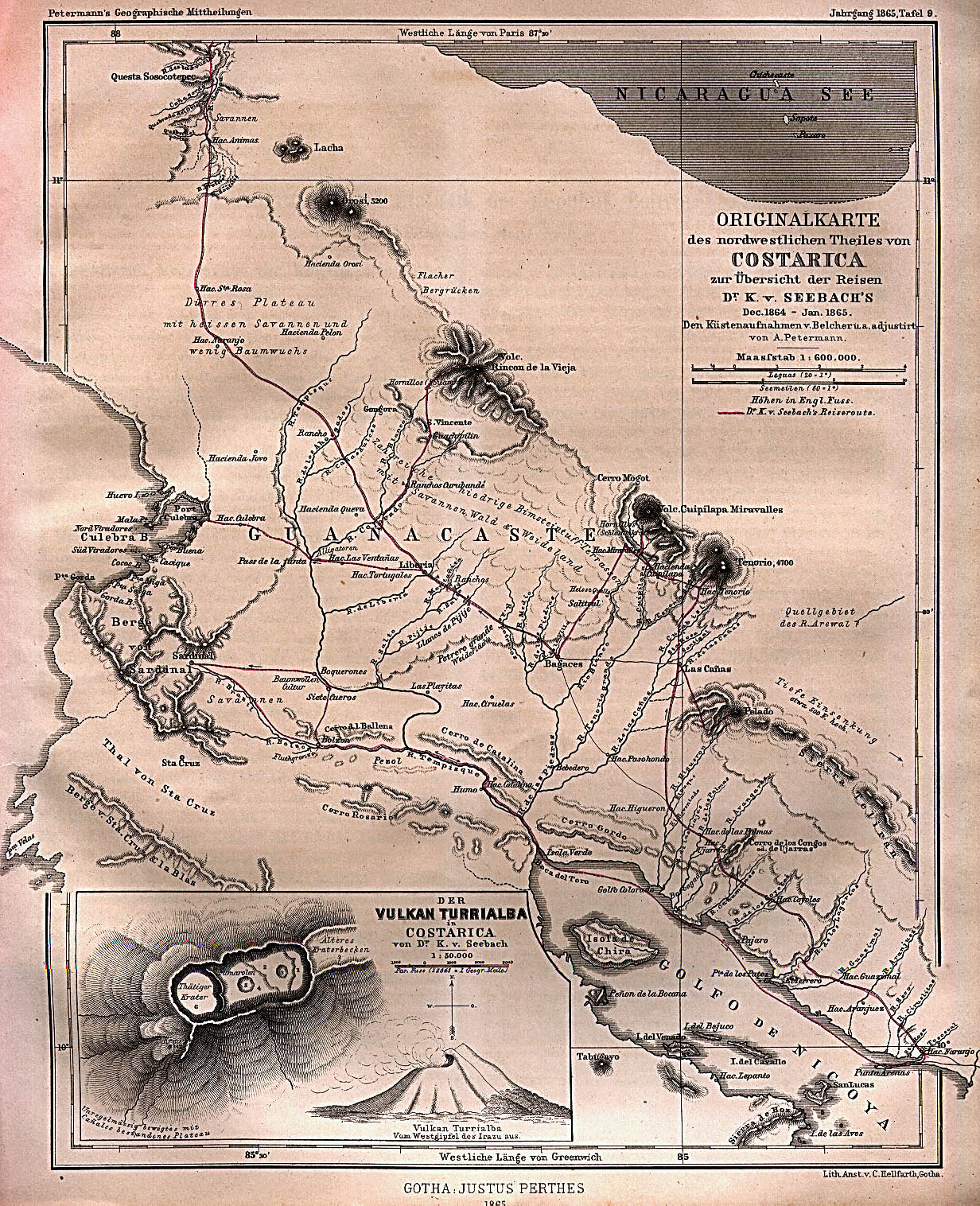
- Costa Rica - Northwest 1865 (647K)
- "Originalkarte des nordwestlichen Theiles von Costarica" from Mittheilungen aus Justus Perthes' Geographischer Anstalt uber Wichtige Neue Erforschungen auf dem Gesammtgebiete der Geographie von Dr. A. Petermann. Volume 9, 1865.
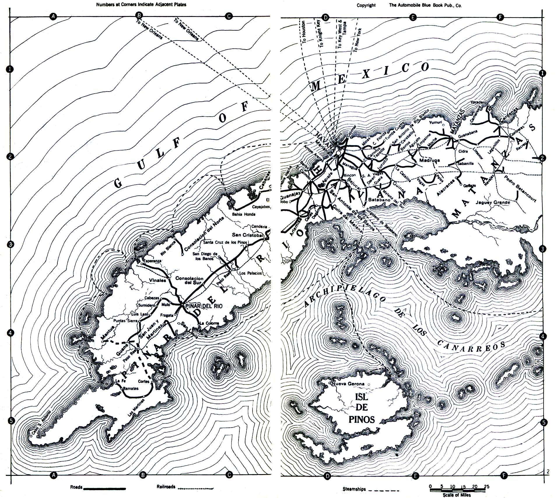
- Cuba 1919 (323K)
- From The Automobile Blue Book, Volume Six, 1919.
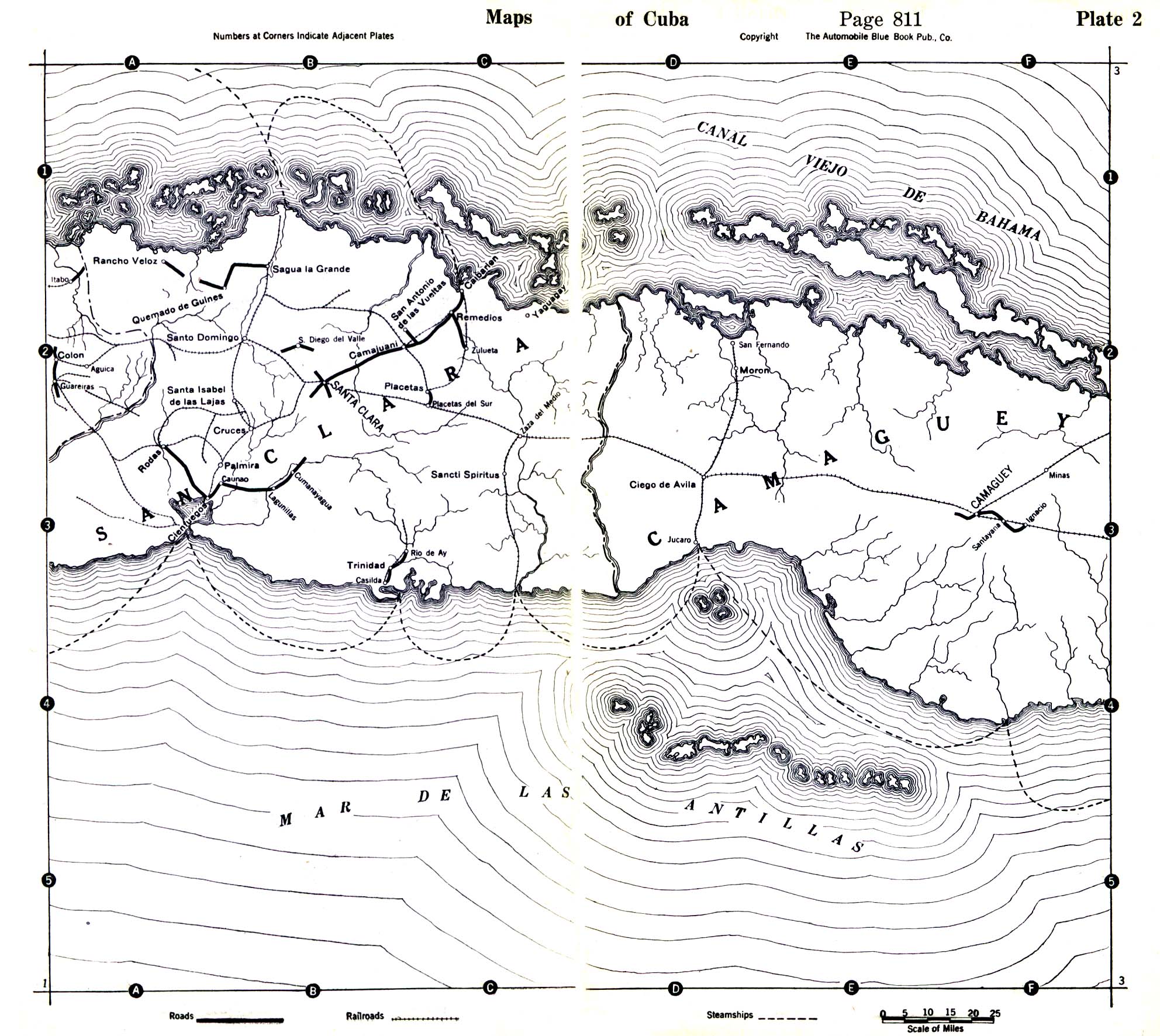
- Cuba - Central Cuba 1919 (645K)
- From The Automobile Blue Book, Volume Six, 1919.
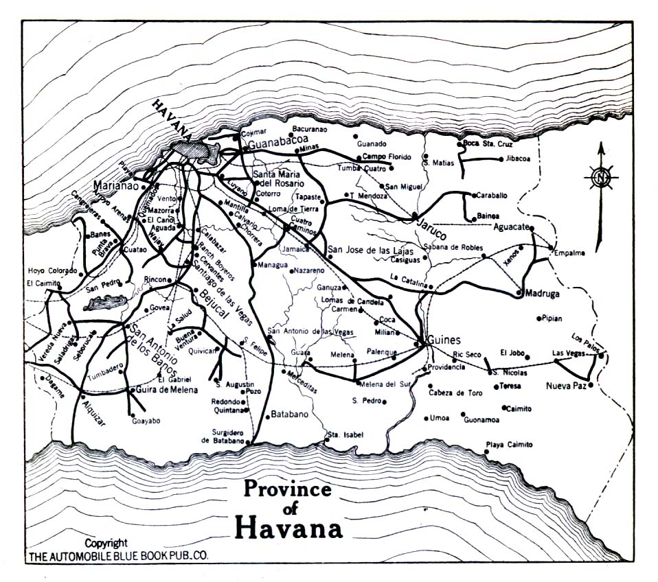
- Cuba - Province of Havana 1919 (323K)
- From The Automobile Blue Book, Volume Six, 1919.
- Fraser River [British Columbia] 1859 (249K)
- "Karte des Fraser River" From Mittheilungen aus Justus Perthes' Geographischer Anstalt uber Wichtige Neue Erforschungen auf dem Gesammtgebiete der Geographie von Dr. A. Petermann. Volume 6, 1860.
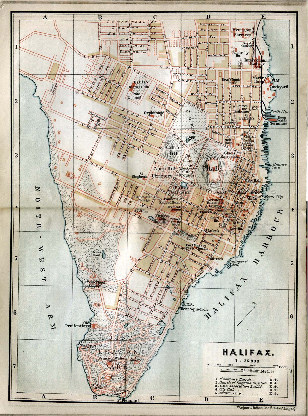
- Halifax, Canada 1894 (438K)
- From The Dominion of Canada, with Newfoundland and an Excursion to Alaska. Handbook for Travellers, by Karl Baedeker, 1894.
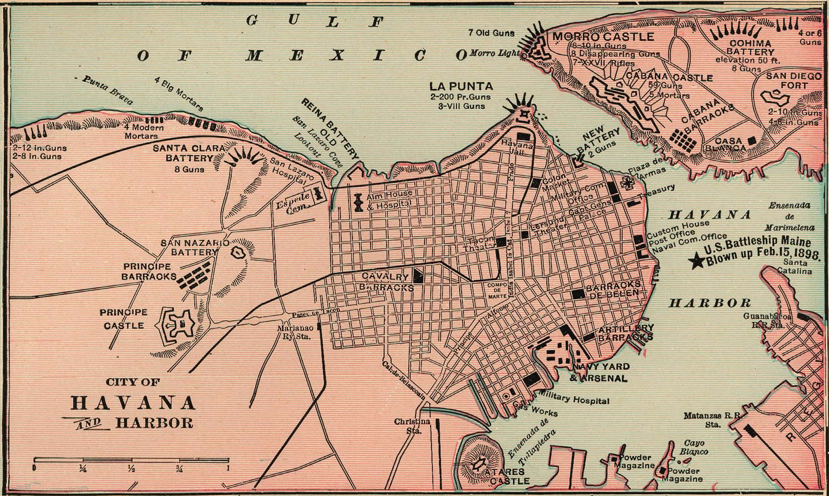
- Havana Harbor 1901 (434K)
- From Cram's Modern Atlas, 1901.
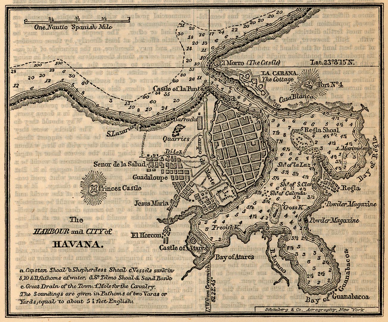
- Havana - Harbour and City 1858 (413K)
- "The Harbour and City of Havana" from A Cyclopedia of Commerce and Commercial Cavigation by I. Smith (Isaac Smith) Homans, 1858.
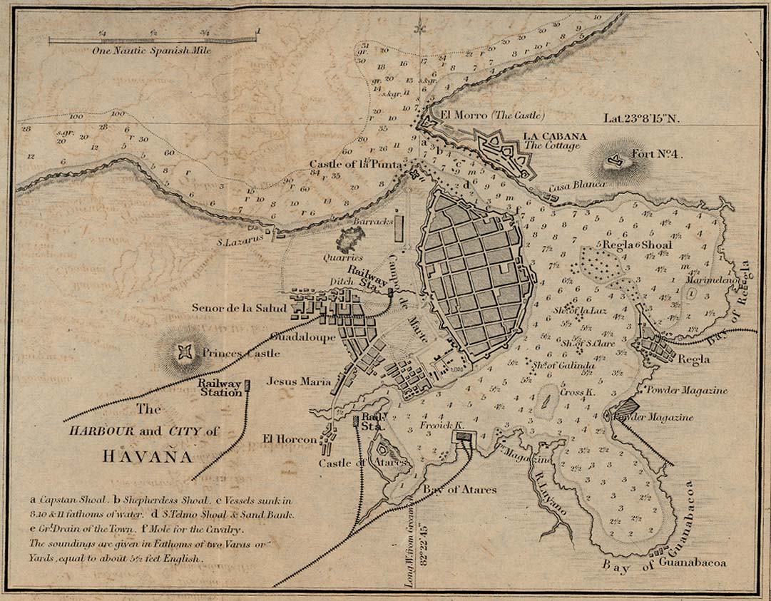
- Havana - Harbour and City 1882 (209K)
- From A Dictionary, Practical, Theoretical, and Historical of Commerce and Commercial Navigation, by J. R. (John Ramsay) McCulloch, 1882.
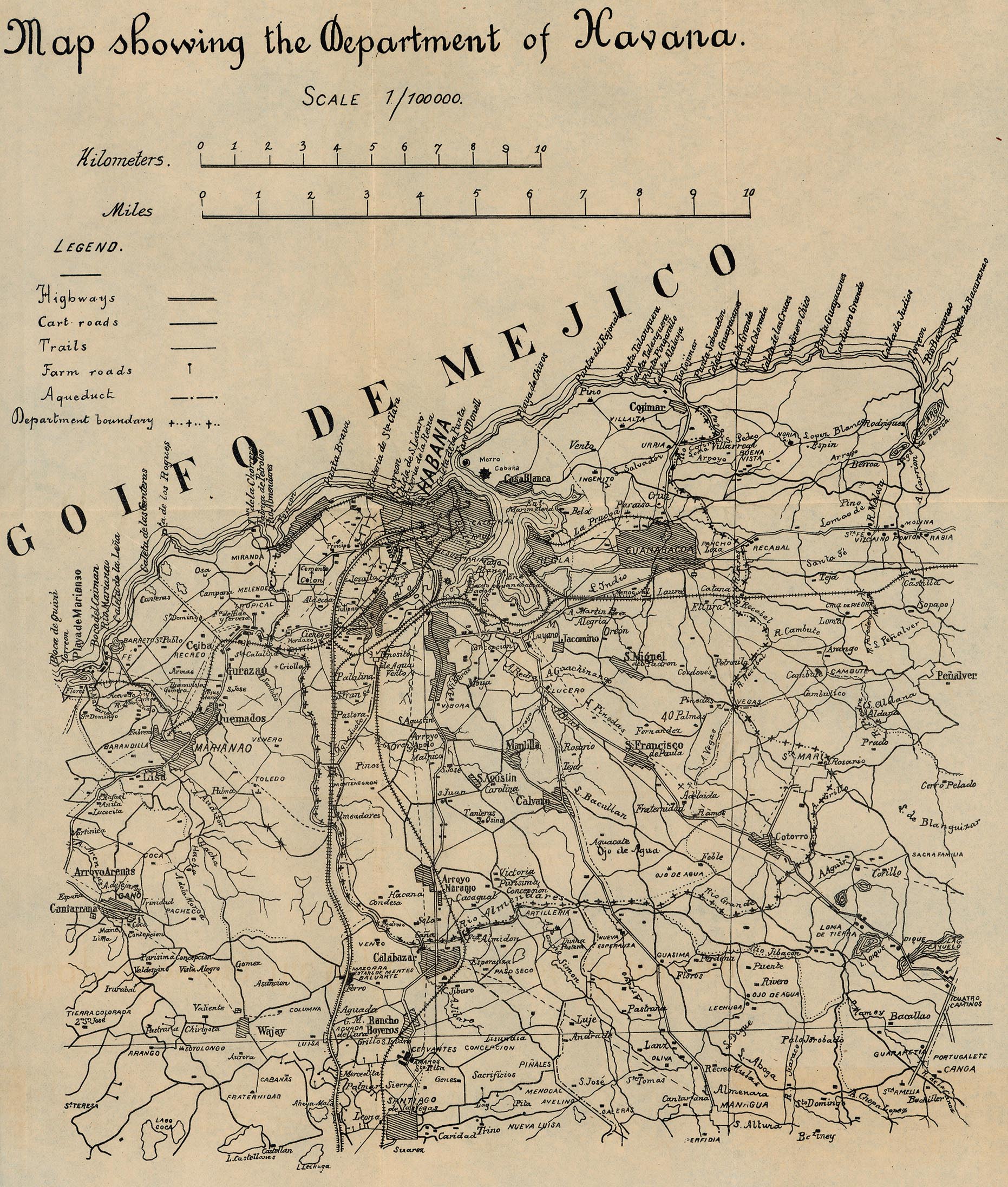
- Havana - Map Showing the Department of Havana 1899 (940K)
- From 56th Congress, 1st Session. House of Representatives. Document No. 2. Annual Reports of the War Department for the Fiscal Year Ended June 30, 1899. Washington: Government Printing Office. 1899.
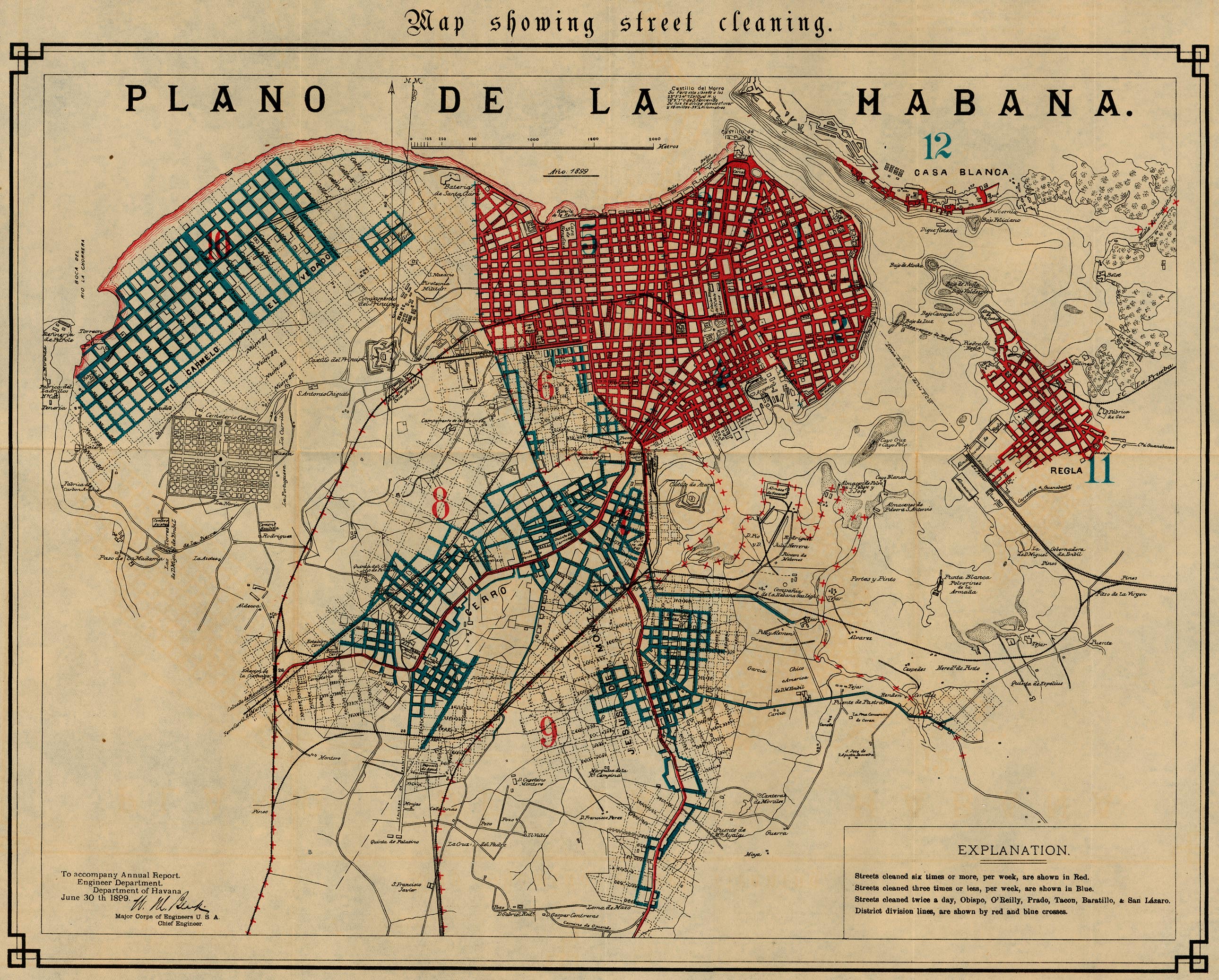
- Havana - Map Showing Street Cleaning 1899 (1,382K)
- From 56th Congress, 1st Session. House of Representatives. Document No. 2. Annual Reports of the War Department for the Fiscal Year Ended June 30, 1899. Washington: Government Printing Office. 1899.
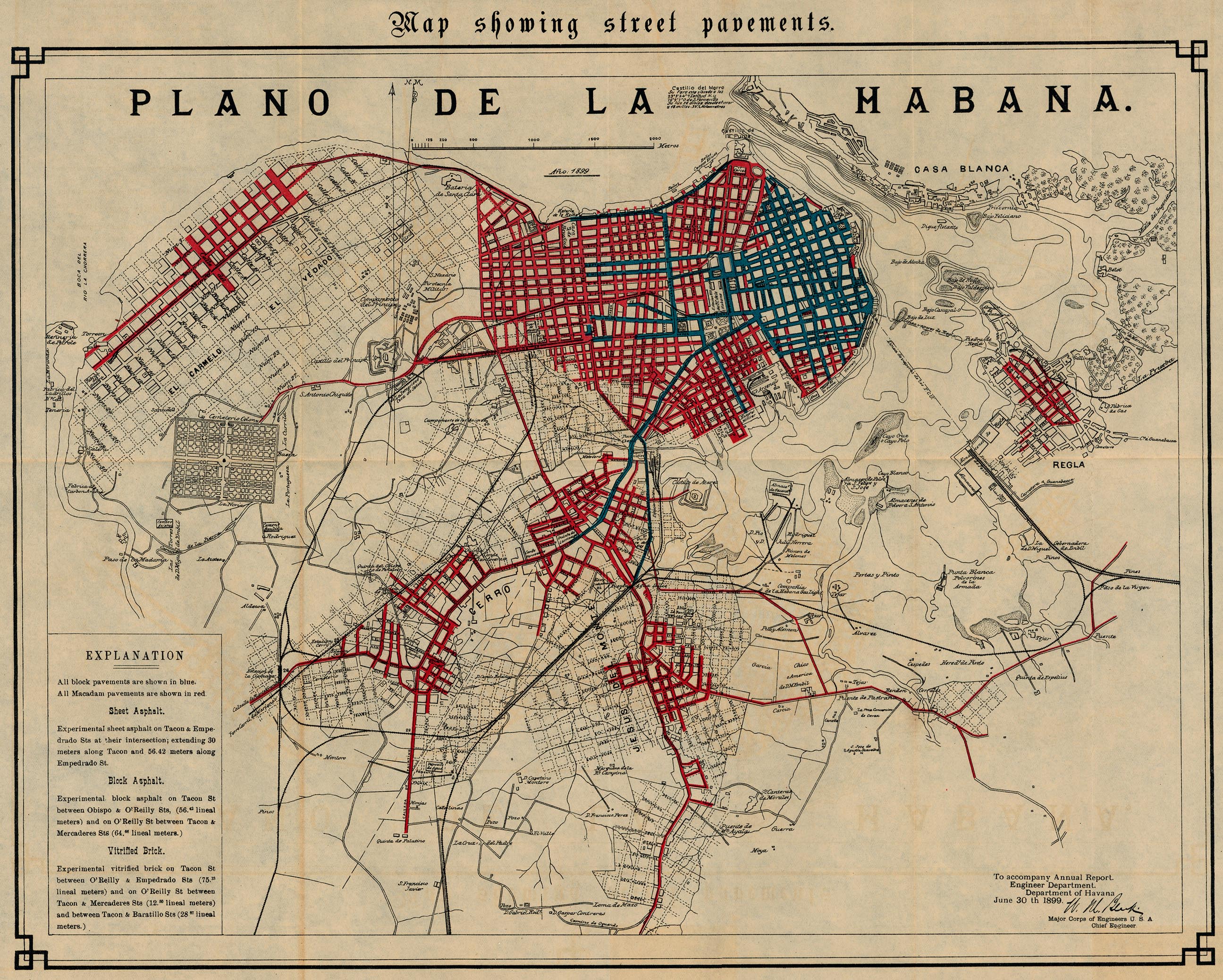
- Havana - Map Showing Street Pavements 1899 (1,372K)
- From 56th Congress, 1st Session. House of Representatives. Document No. 2. Annual Reports of the War Department for the Fiscal Year Ended June 30, 1899. Washington: Government Printing Office. 1899.
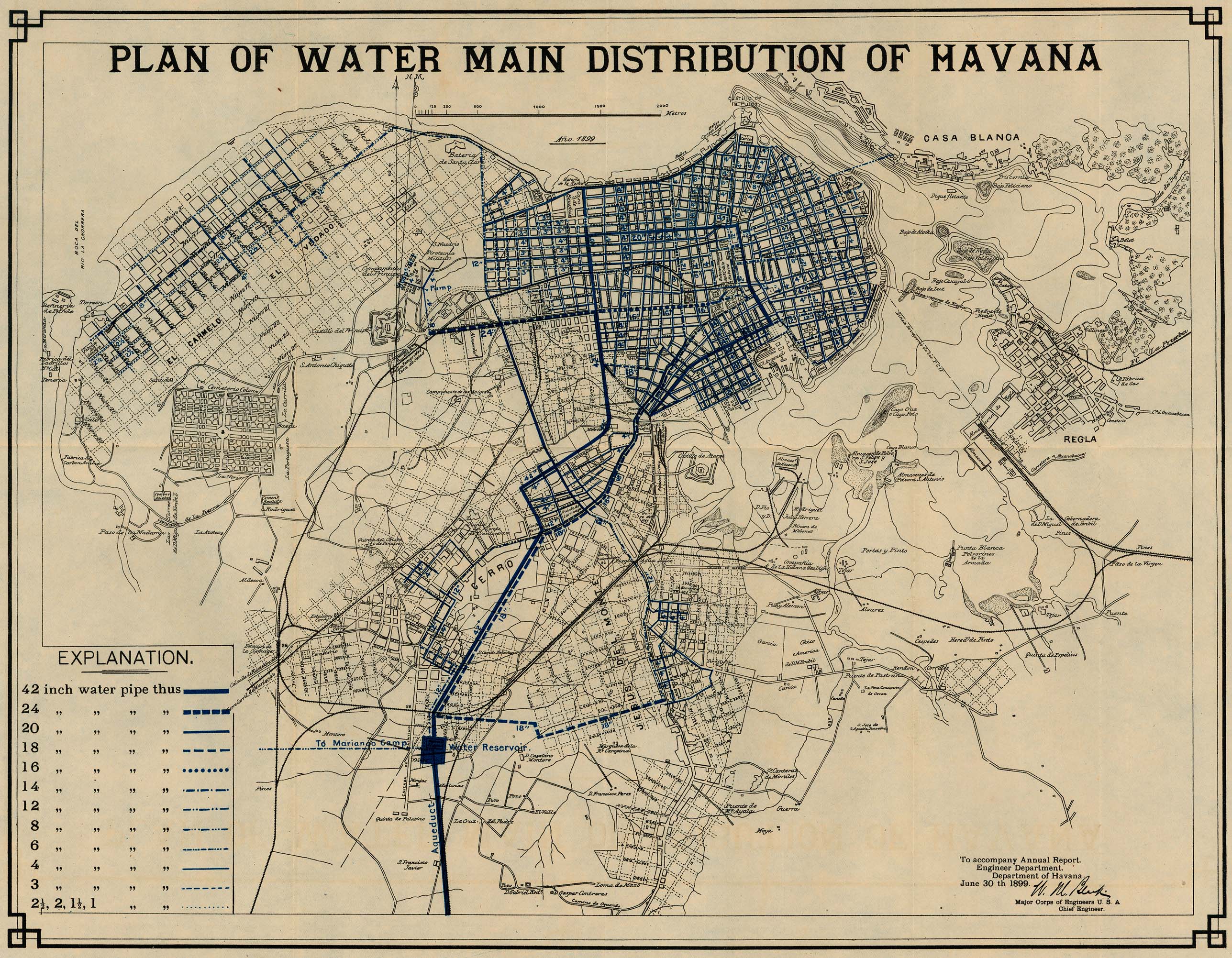
- Havana - Plan of Water Main Distribution 1899 (1,124K)
- From 56th Congress, 1st Session. House of Representatives. Document No. 2. Annual Reports of the War Department for the Fiscal Year Ended June 30, 1899. Washington: Government Printing Office. 1899.
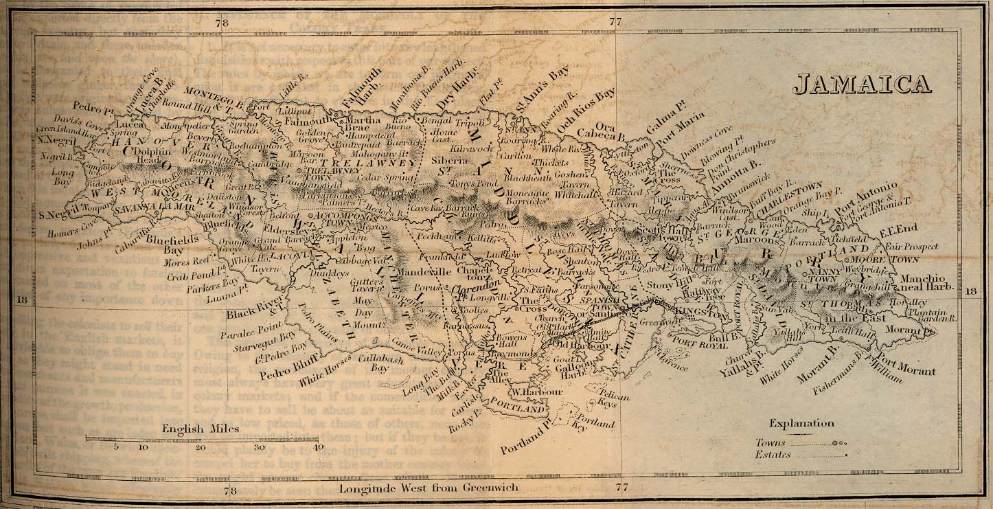
- Jamaica 1882 (259K)
- From A Dictionary, Practical, Theoretical, and Historical of Commerce and Commercial Navigation, by J. R. (John Ramsay) McCulloch, 1882.
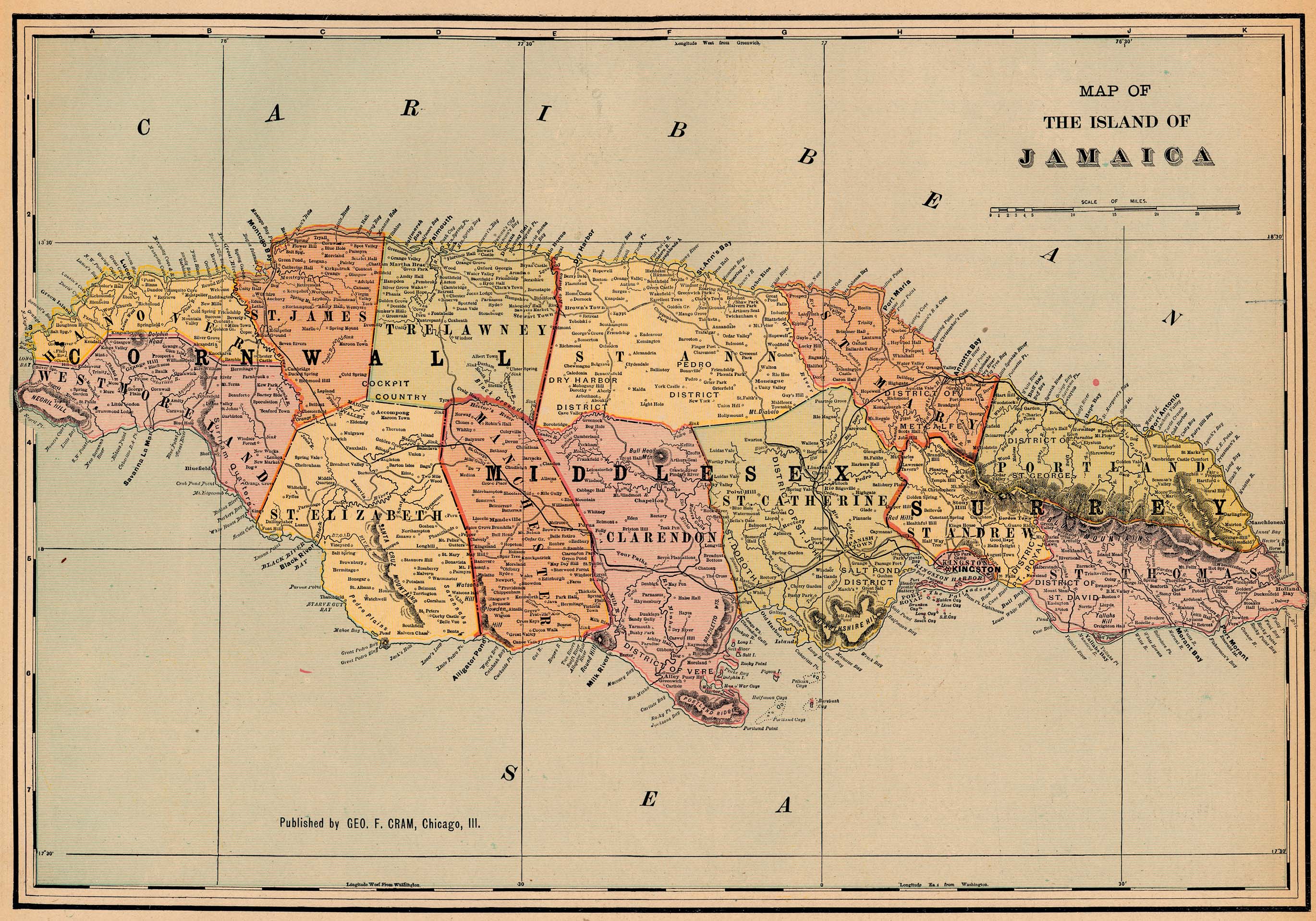
- Jamaica 1901 (1,098K)
- "Map of the Island of Jamaica" from Cram's Modern Atlas the New Unrivaled. Published by George F. Cram, 1901.
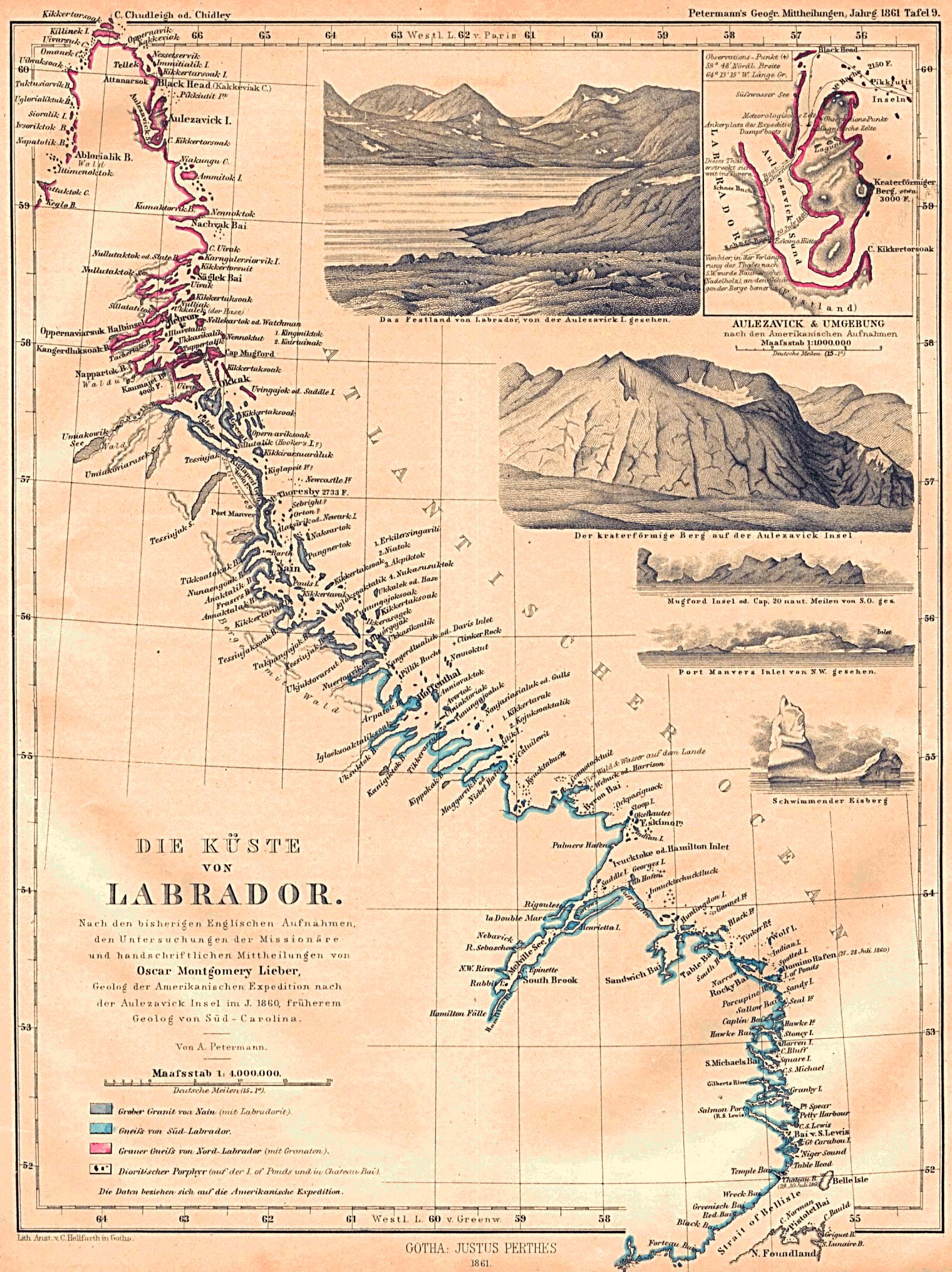
- Labrador Coast 1861 (649K)
- "Die Kuste von Labrador" From Mittheilungen aus Justus Perthes' Geographischer Anstalt uber Wichtige Neue Erforschungen auf dem Gesammtgebiete der Geographie von Dr. A. Petermann. Volume 7, 1861.
- Manitoba 1921 (1207K)
- From Putnam's Handy Volume Atlas of the World. Published by G.P. Putnam's Sons, New York and London, 1921.
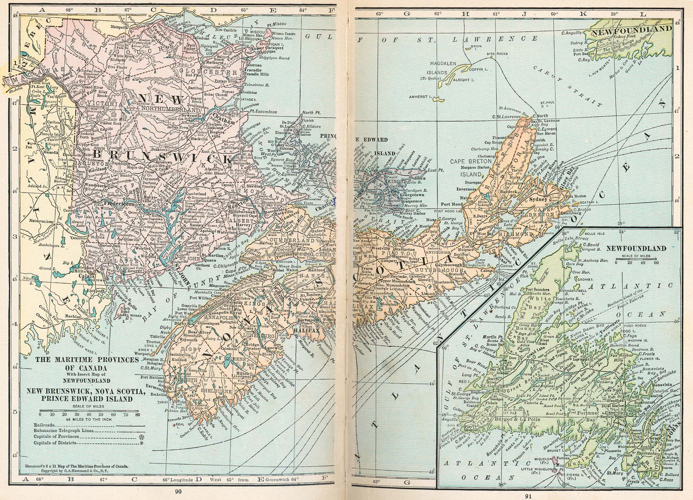
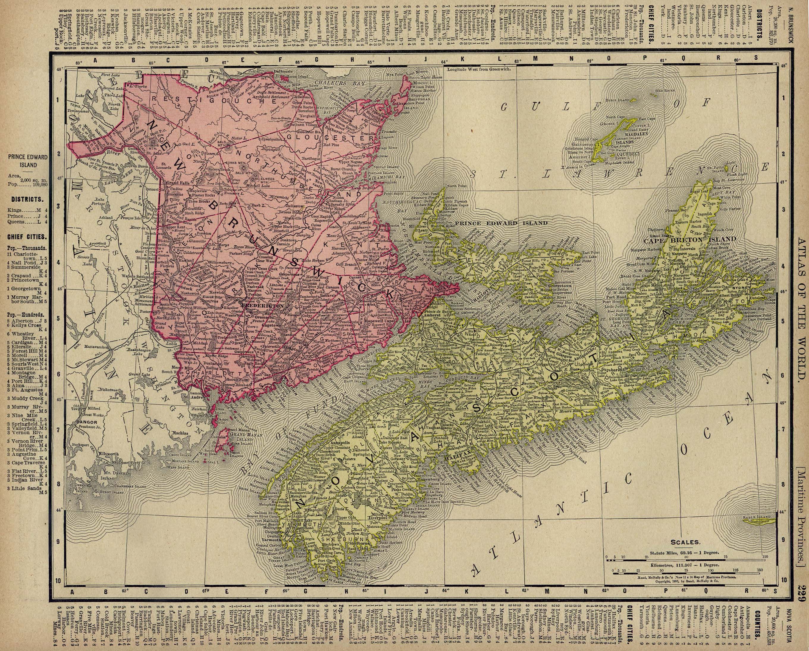
- Maritime Provinces, Canada 1921 (947K)
- From Putnam's Handy Volume Atlas of the World. Published by G.P. Putnam's Sons, New York and London, 1921.
- [Mexico] Passage by Land to California 1731 (1.2MB)
- Eusebio Francisco Kino. A Passage by Land to California Discover�d by ye. Rev. Fathr. Eusebius Francis Kino, Jesuite between ye Years 1698 & 1701. Based on Father Kino's map. This English edition was published in Part II of The Philosophical Transactions (From the Year 1700, to the Year 1720.) Plate IX. Vol. V. Part II. page 192. London, 1731. Second English edition of Kino�s momentous map of California refuting the concept of an insular California. Courtesy Dorothy Sloan-Rare Books, Austin, Texas
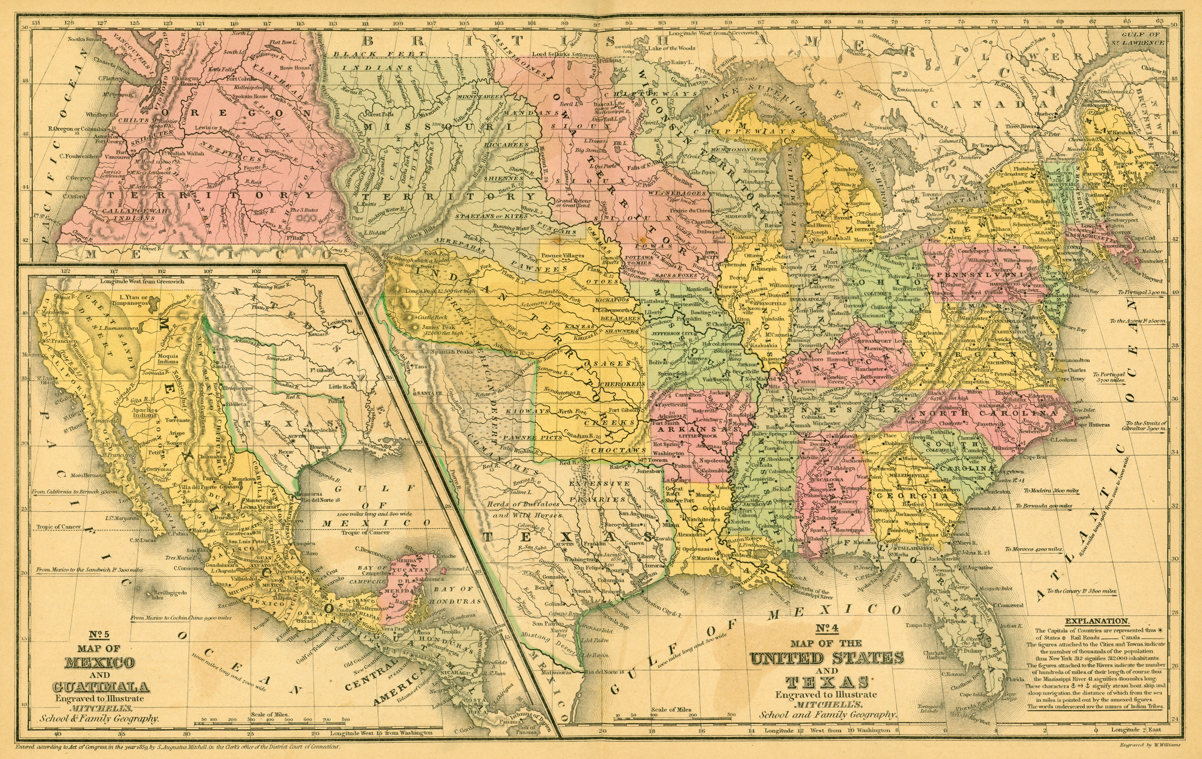
- Mexico and United States 1839 (3.2MB)
- Map of Mexico and Guatimala Engraved to Illustrate Mitchell's School and Family Geography [with] Map of the United States and Texas... From Mitchell's School Atlas by S. Augustus Mitchell. Philadelphia: Thomas, Cowperthwait & Company, [1844]. Map courtesy Dorothy Sloan-Rare Books, Austin, Texas
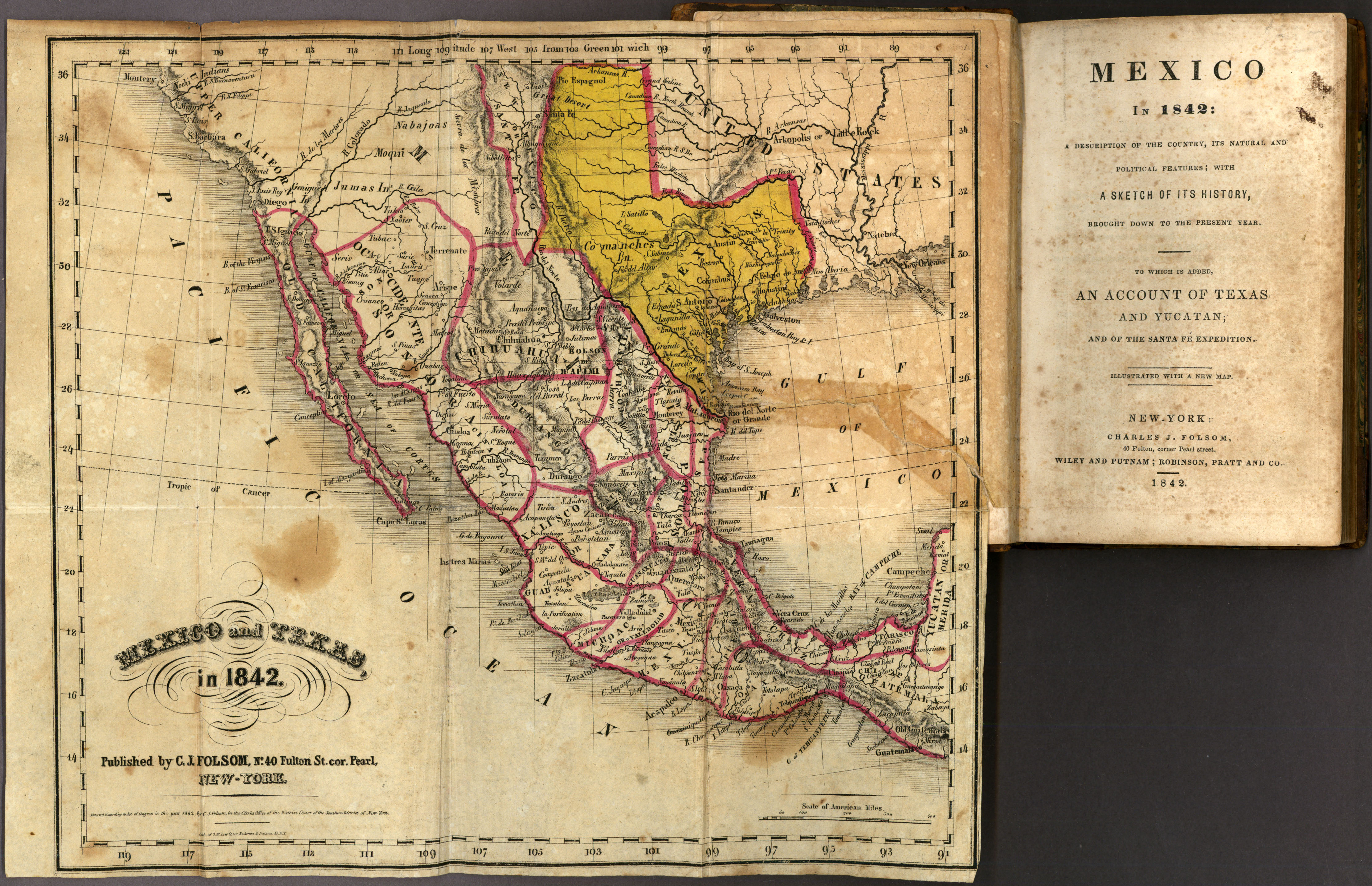
- Mexico 1842 (2.8MB)
- From Mexico in 1842: A Description of the Country, Its Natural and Political Features...by George Folsom. New York: Charles J. Folsom; Wiley and Putnam; Robinson, Pratt and Co., 1842. Map courtesy Dorothy Sloan-Rare Books, Austin, Texas
- Mexico 1919
- Maps from A Handbook of Mexico. Great Britain. Naval Intelligence Division, 1919.
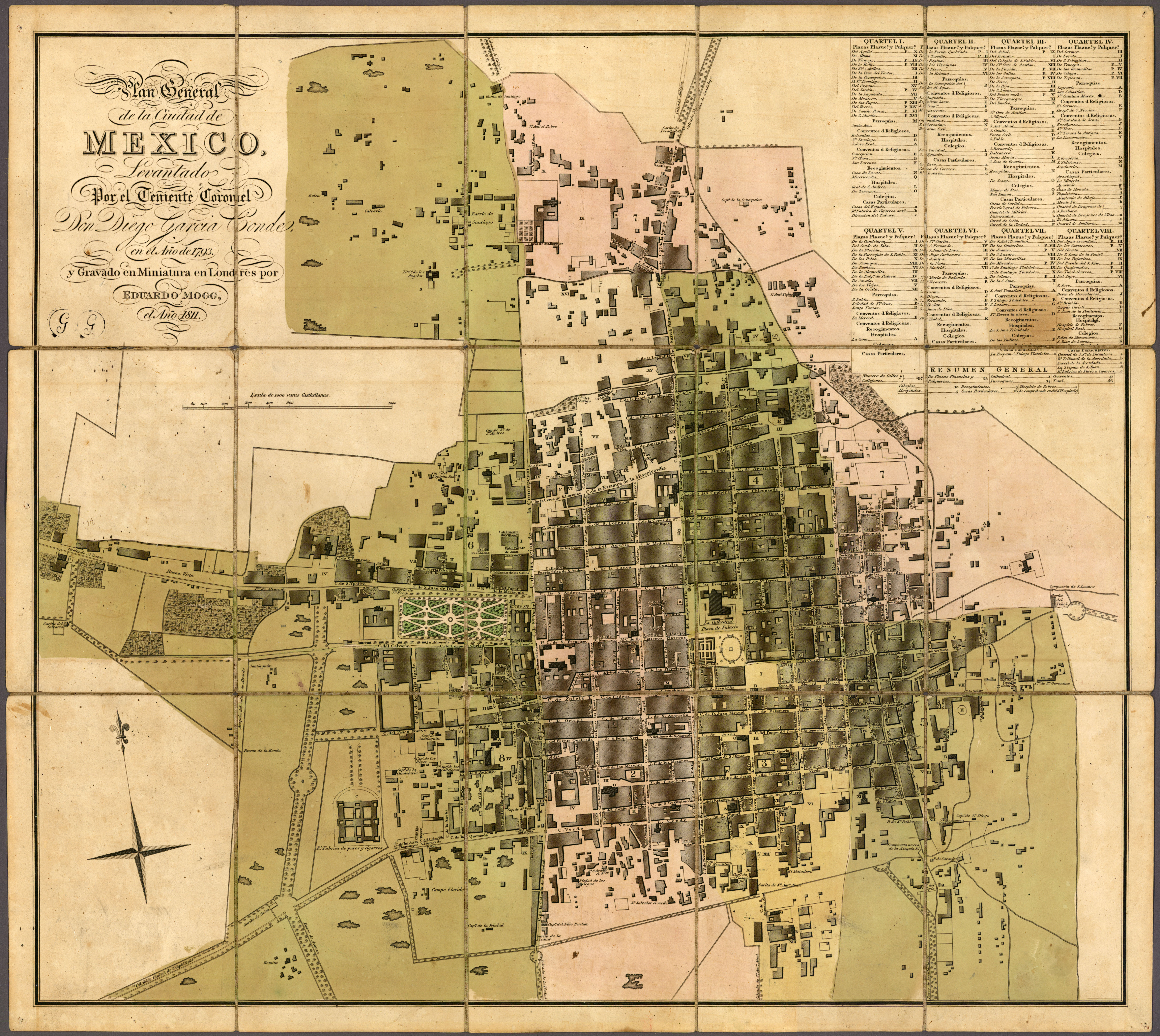
- Mexico City 1811 (6.5MB)
- Based on a 1793 survey. Plan General de la Ciudad de México... by Diego Garcia Conde. London: Edward Mogg, 1811. Map courtesy Dorothy Sloan-Rare Books, Austin, Texas
- Montreal 1830 (168K)
- From The Northern Traveller, and Northern Tour; with the Routes to The Springs, Niagara, and Quebec, and the Coal Mines of Pennsylvania; also, the Tour of New-England. New York, 1830.
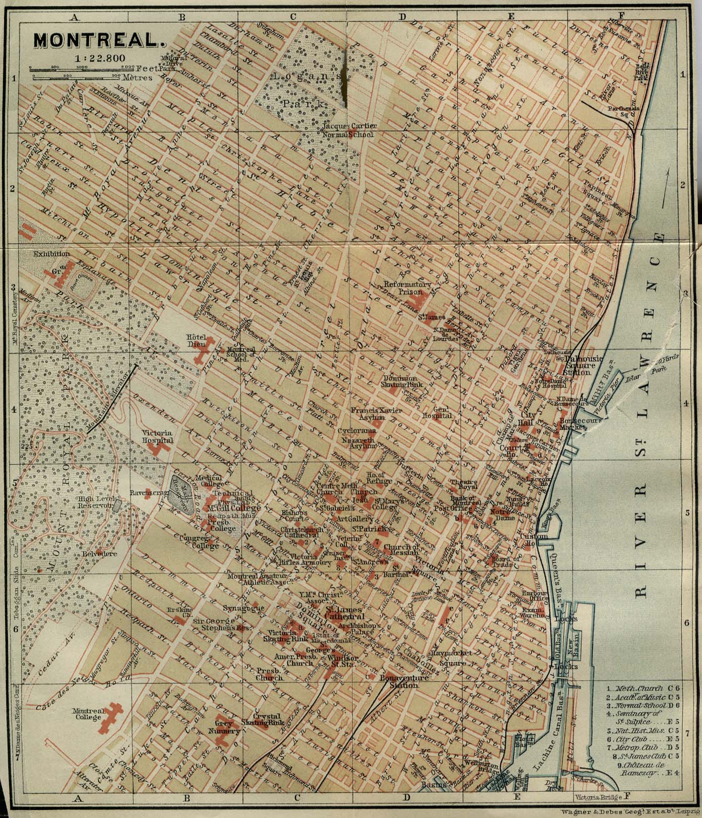
- Montreal 1894 (476K)
- "Montreal" from Baedeker, Karl. The Dominion of Canada with Newfoundland and an Excursion to Alaska. Leipsic, 1894.
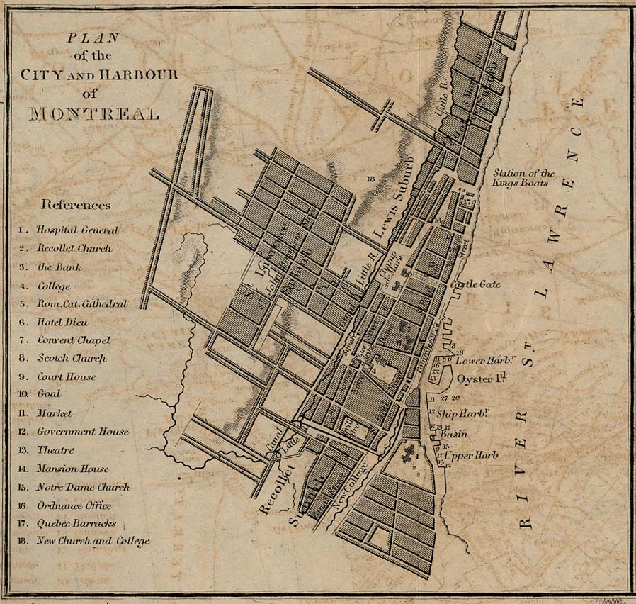
- Montreal - Plan of the City and Harbour 1882 (225K)
- From A Dictionary, Practical, Theoretical, and Historical of Commerce and Commercial Navigation, by J. R. (John Ramsay) McCulloch, 1882.
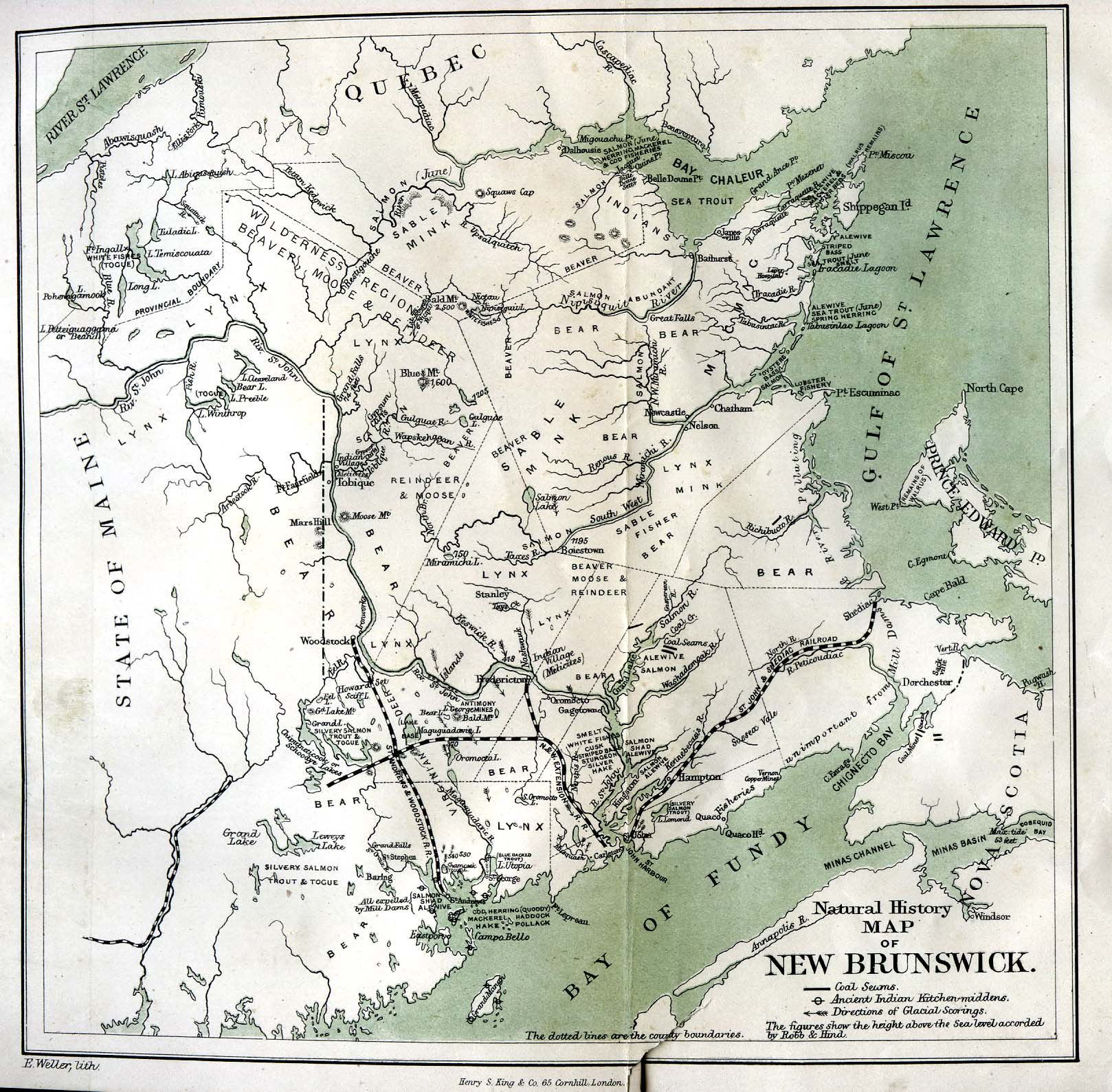
- New Brunswick 1873 (505K)
- "Natural History Map of New Brunswick" from Field and Forest Rambles with Notes and Observations on the Natural History of Eastern Canada, by A. Leith Adams, 1873.
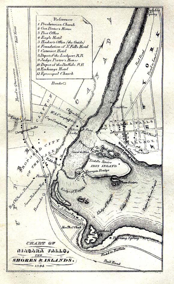
- Niagara Falls 1844 (258K)
- "Chart of Niagara Falls the Shores and Islands in 1844" from The Picturesque Tourist: Being a Guide Through Northern and Eastern States edited by Orville L. Holley, 1844.
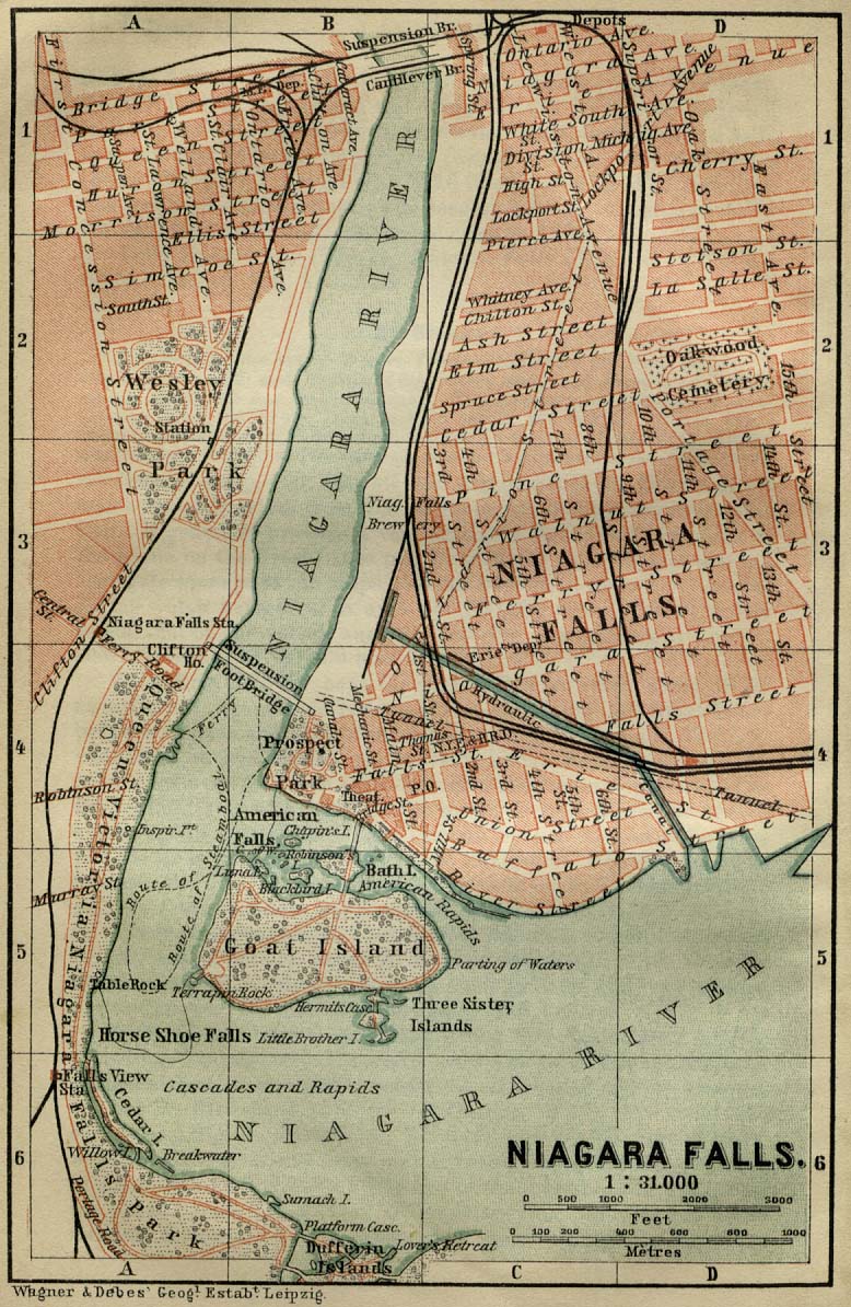
- Niagara Falls 1894 (281K)
- "Niagara Falls" from Baedeker, Karl. The Dominion of Canada with Newfoundland and an Excursion to Alaska. Leipsic, 1894.
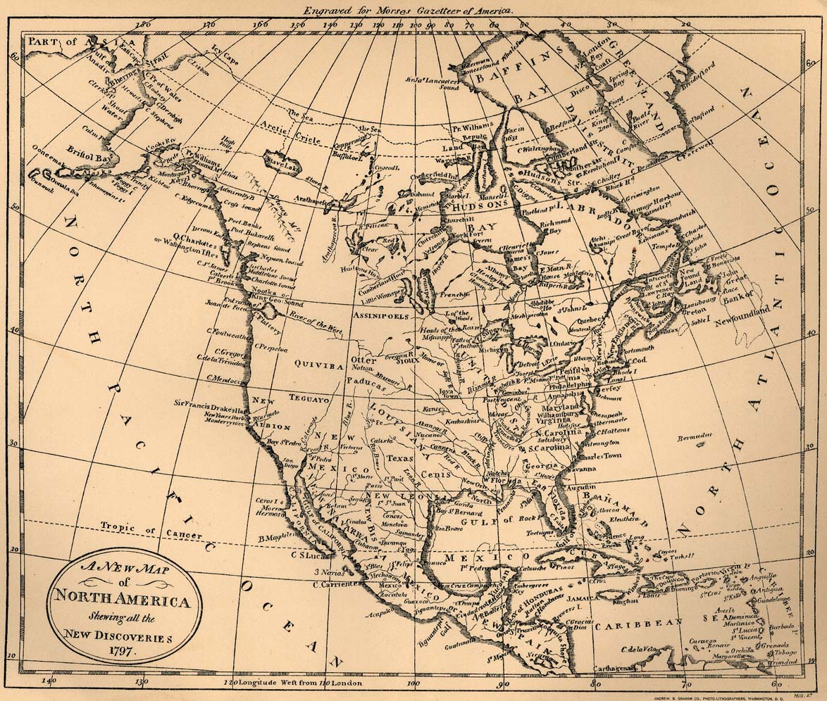
- North America 1797 (362K)
- "A New Map of North America Shewing all the New Discoveries 1797", "Engraved for Morses Gazetteer of America", From "A Century of Population Growth", U.S. Bureau of the Census, 1909.
- North America - Air Control and Warning System [DEW, Mid-Canada, and Pinetree Lines] 1960 (205K)
- From Canada, Free-World Partner. U.S. Department of State Publication 6943, 1960.
- [North America - Southwest] 1841 (1.7MB)
- "Karte vom Rio Grande und dem West Land am Stillen Ocean". From George A. Scherpf, "Entstehungsgeschichte und gegenw�rtiger Zustand des neuen, unabh�ngigen, amerikanischen Staates Texas. Ein Beitrag zur Geschichte, Statistik und Geographie dieses Jahrhunderts, Im Lande selbst gesammelt von G. A. Scherpf. Mit zwei Karten, von Texas, Rio Grande und dem West-Land am Stillen Ocean". Augsburg: Verlag der Matth. Rieger�schen Buchhandlung, 1841. A re-drawing on smaller scale of the inset of Hunt and
Randel�s 1839 map. Map courtesy Dorothy Sloan-Rare Books, Austin, Texas
- Nova Scotia and New Brunswick 1895 (1.1MB)
- From Rand, McNally & Co.'s Universal Atlas of The World. Edition 1896.
- Ontario - Northern Part 1921 (789K)
- From Putnam's Handy Volume Atlas of the World. Published by G.P. Putnam's Sons, New York and London, 1921.
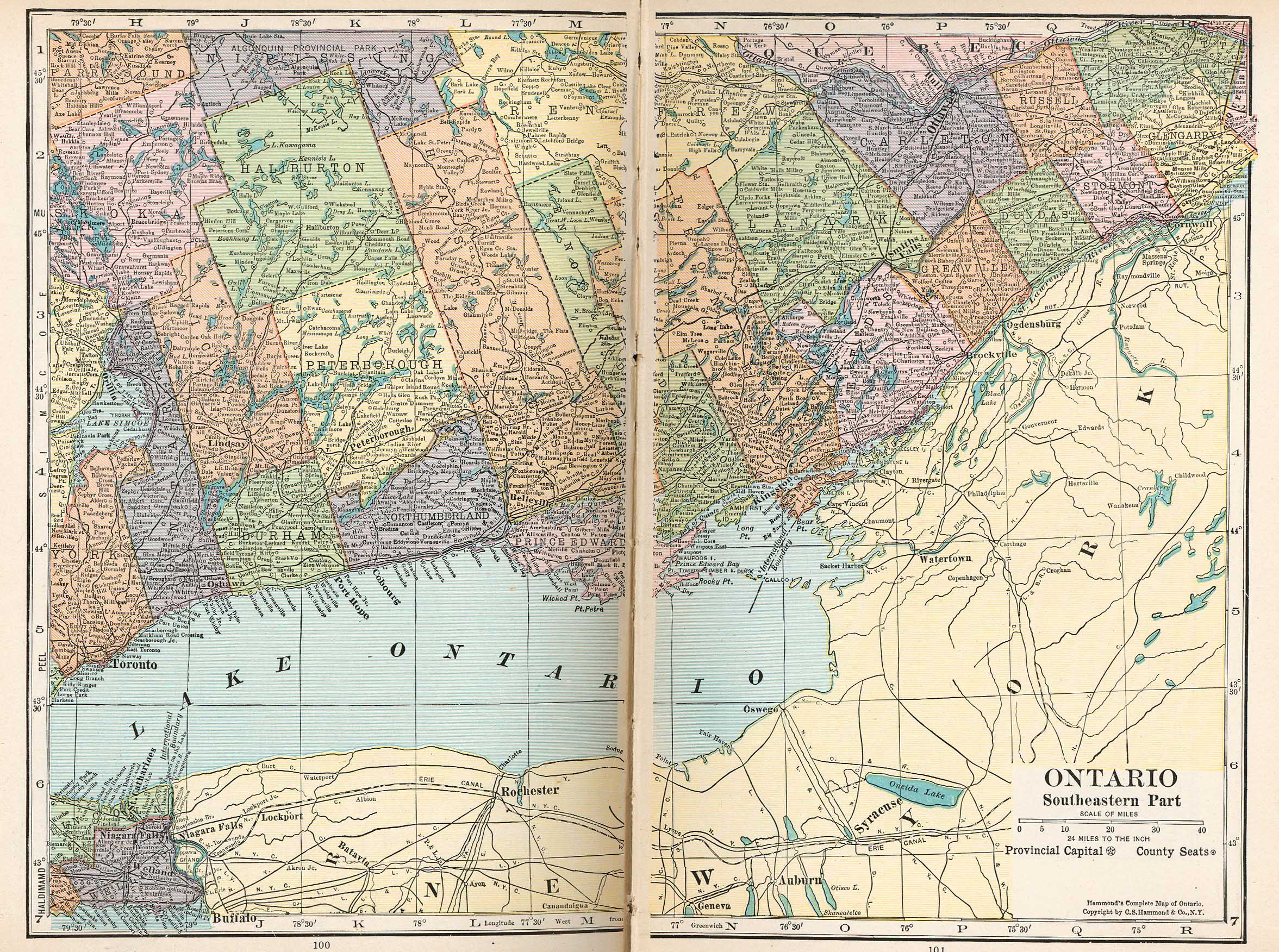
- Ontario - Southeastern Part 1921 (1172K)
- From Putnam's Handy Volume Atlas of the World. Published by G.P. Putnam's Sons, New York and London, 1921.
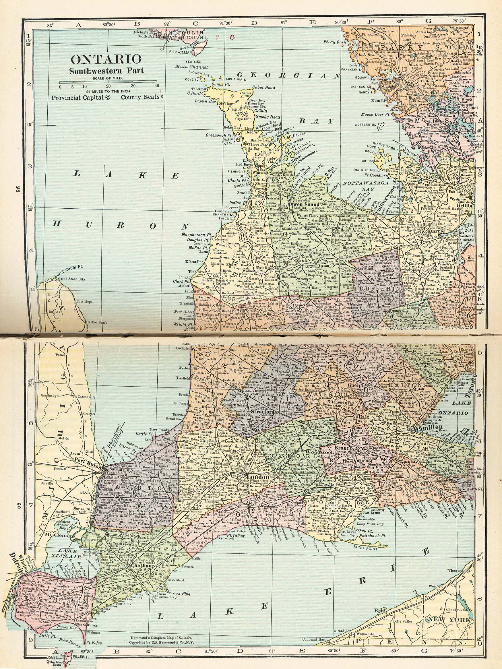
- Ontario - Southwestern Part 1921 (1063K)
- From Putnam's Handy Volume Atlas of the World. Published by G.P. Putnam's Sons, New York and London, 1921.
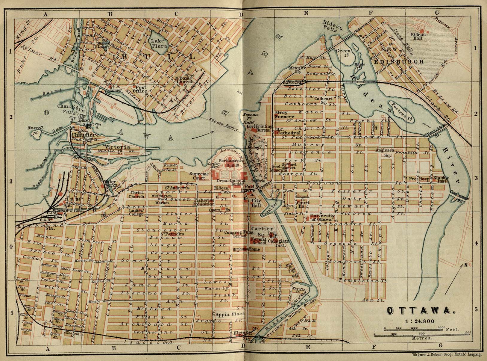
- Ottawa 1894 (365K)
- "Ottawa" from Baedeker, Karl. The Dominion of Canada with Newfoundland and an Excursion to Alaska. Leipsic, 1894.
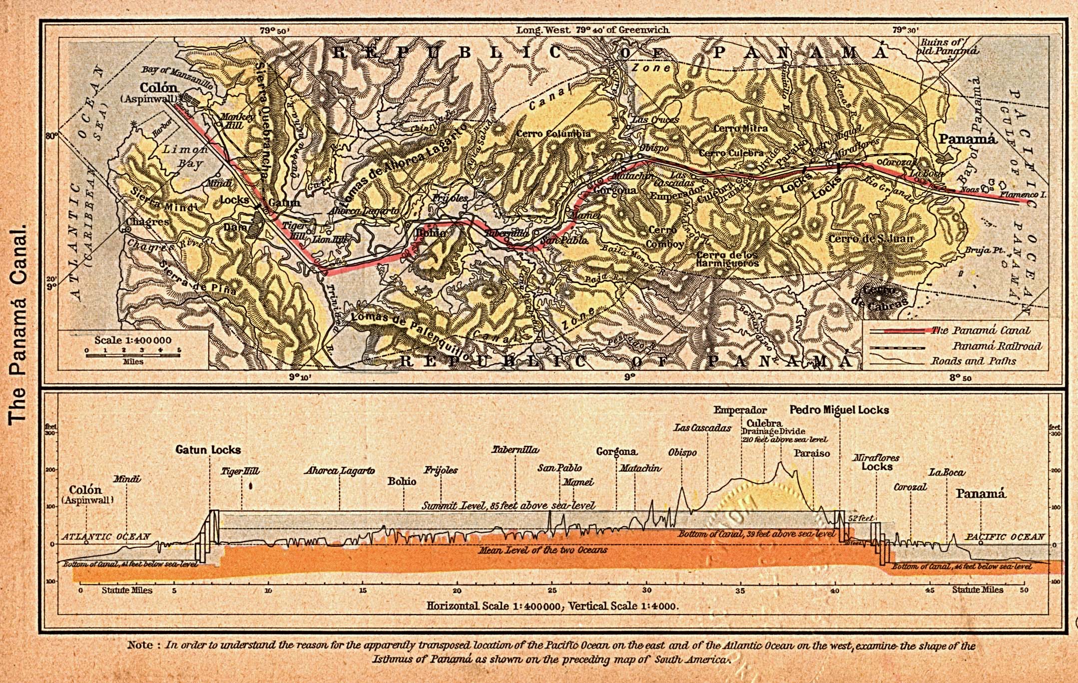
- The Panama Canal (757K)
- The Canal Zone. Profile of the Canal. From The Historical Atlas by William R. Shepherd, 1923.
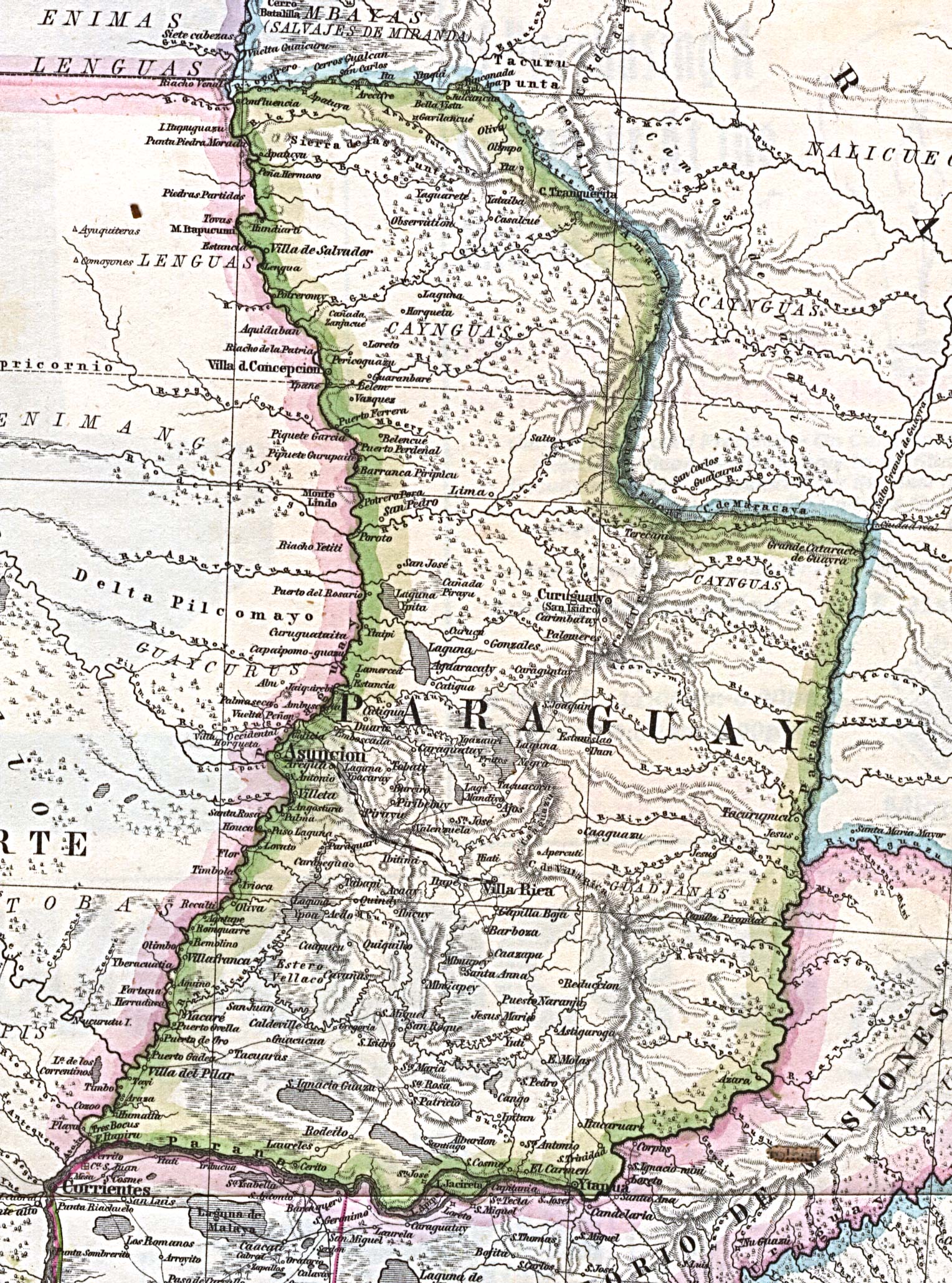
- Paraguay 1875 (916K)
- Part of "Mapa Original de la Republica Argentina y Estados Adyacentes Comprendiendo Las Republicas Chile, Paraguay y Uruguay". 1:4,000,000. From Mittheilungen aus Justus Perthes' Geographischer Anstalt uber Wichtige Neue Erforschungen auf dem Gesammtgebiete der Geographie von Dr. A. Petermann. Volume 9, 1875.
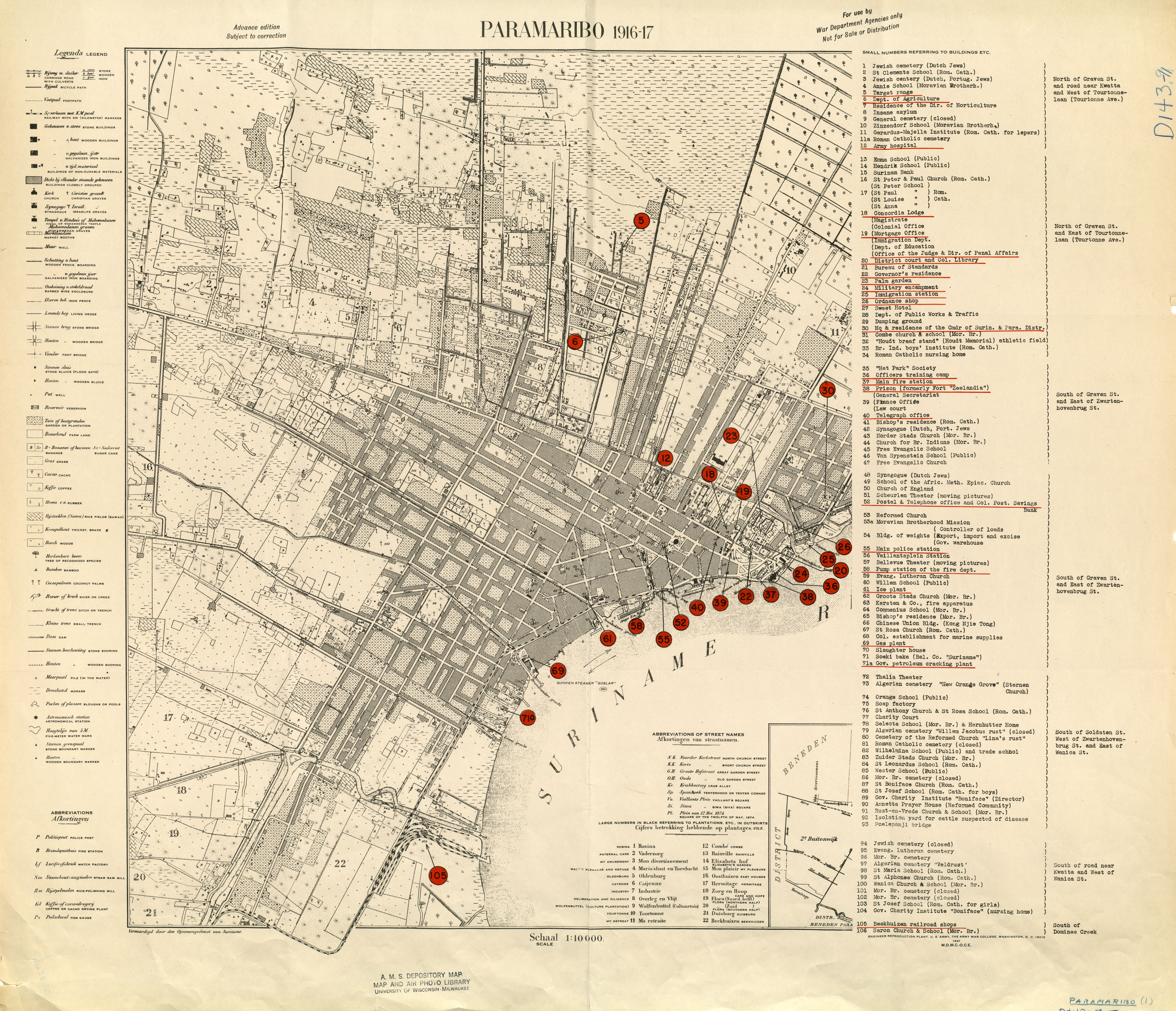
- Paramaribo 1916-17 (4.6MB)
- 1:10,000, U.S. Army War College, 1941
- Peel River [Northwest Territories/Yukon] 1845 (504K)
- "Sketch Map of Peel River by Mr. A.K. Isbester, 1845" From The Journal of the Royal Geographical Society.
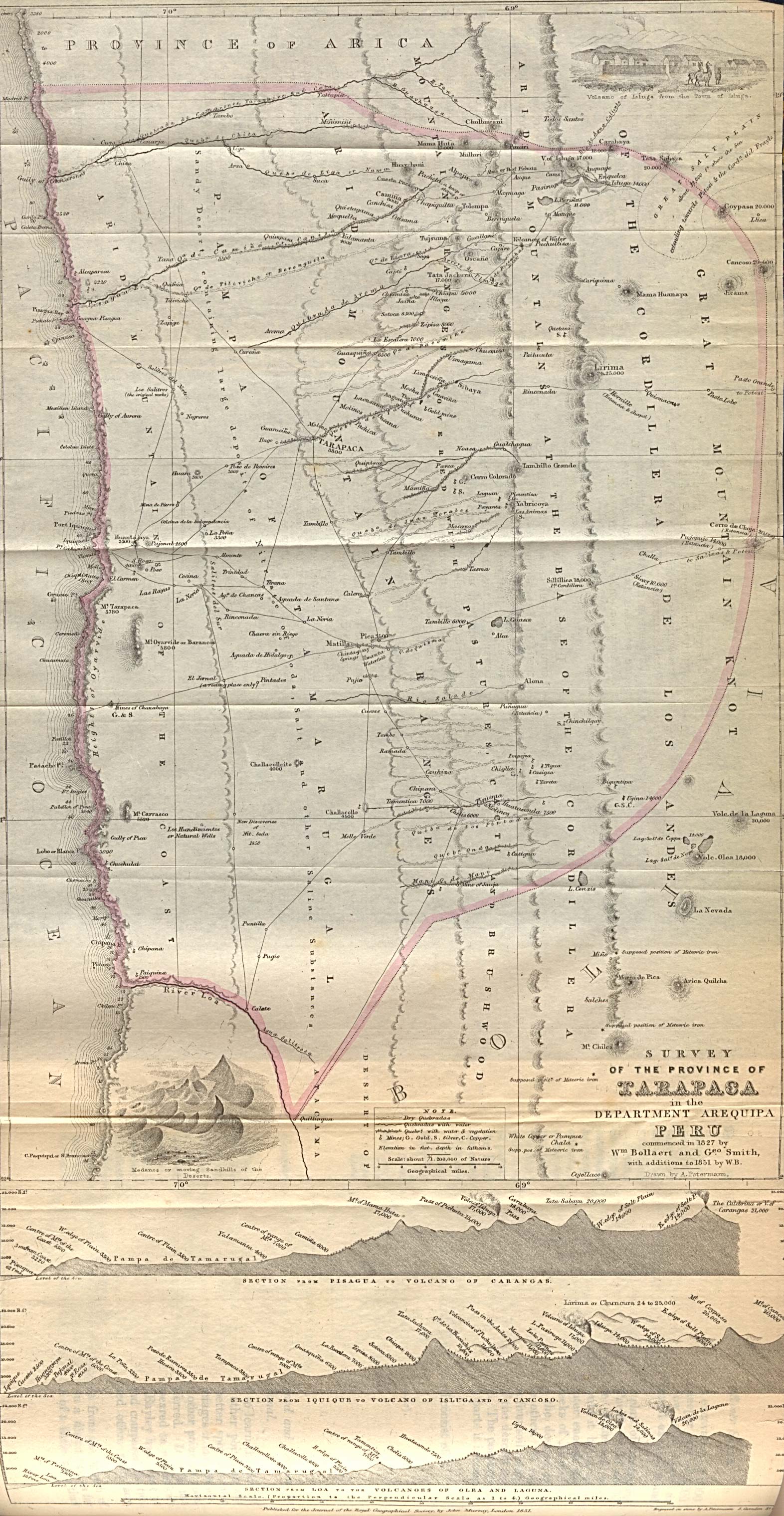
- Peru - Tarapaca Province 1851 (896K)
- "Survey of the Province of Tarapaca in the Department of Arequipa Peru commenced in 1827 by Wm. Bollaert and Geo. Smith with additions to 1851 by W.B." From The Journal of the Royal Geographical Society.
- Porto Rico [Puerto Rico], 1920 (387K)
- Includes inset map "Islands East of Porto Rico." From Putnam's Handy Volume Atlas of the World, 1921.
- Quebec [City], Canada 1894 (428K)
- From The Dominion of Canada, with Newfoundland and an Excursion to Alaska. Handbook for Travellers, by Karl Baedeker, 1894.
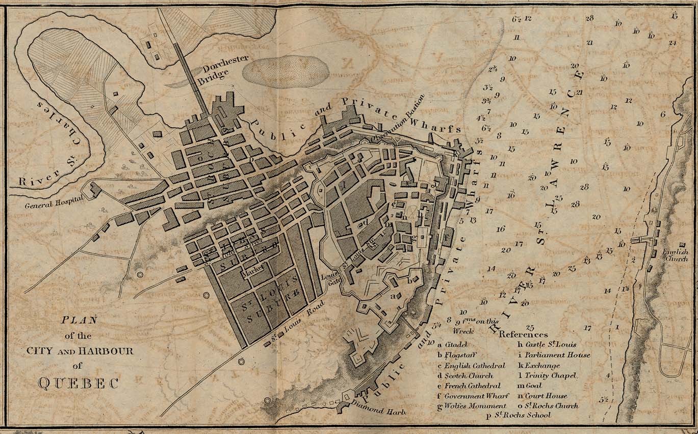
- Quebec - Plan of the City and Harbour 1882 (265K)
- From A Dictionary, Practical, Theoretical, and Historical of Commerce and Commercial Navigation, by J. R. (John Ramsay) McCulloch, 1882.
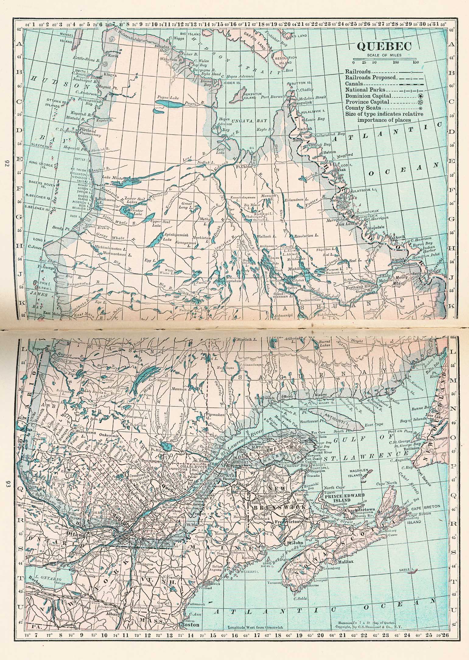
- Quebec 1921 (707K)
- From Putnam's Handy Volume Atlas of the World. Published by G.P. Putnam's Sons, New York and London, 1921.
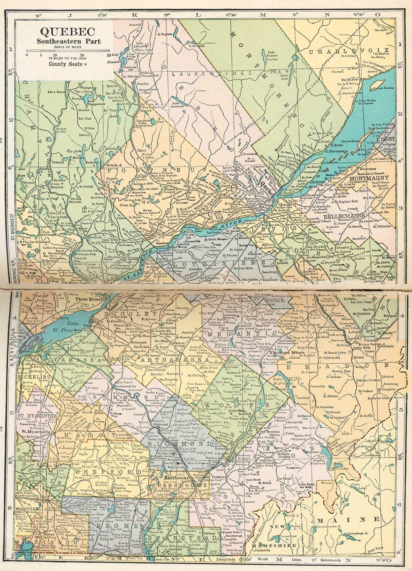
- Quebec - Southeastern Part 1921 (781K)
- From Putnam's Handy Volume Atlas of the World. Published by G.P. Putnam's Sons, New York and London, 1921.
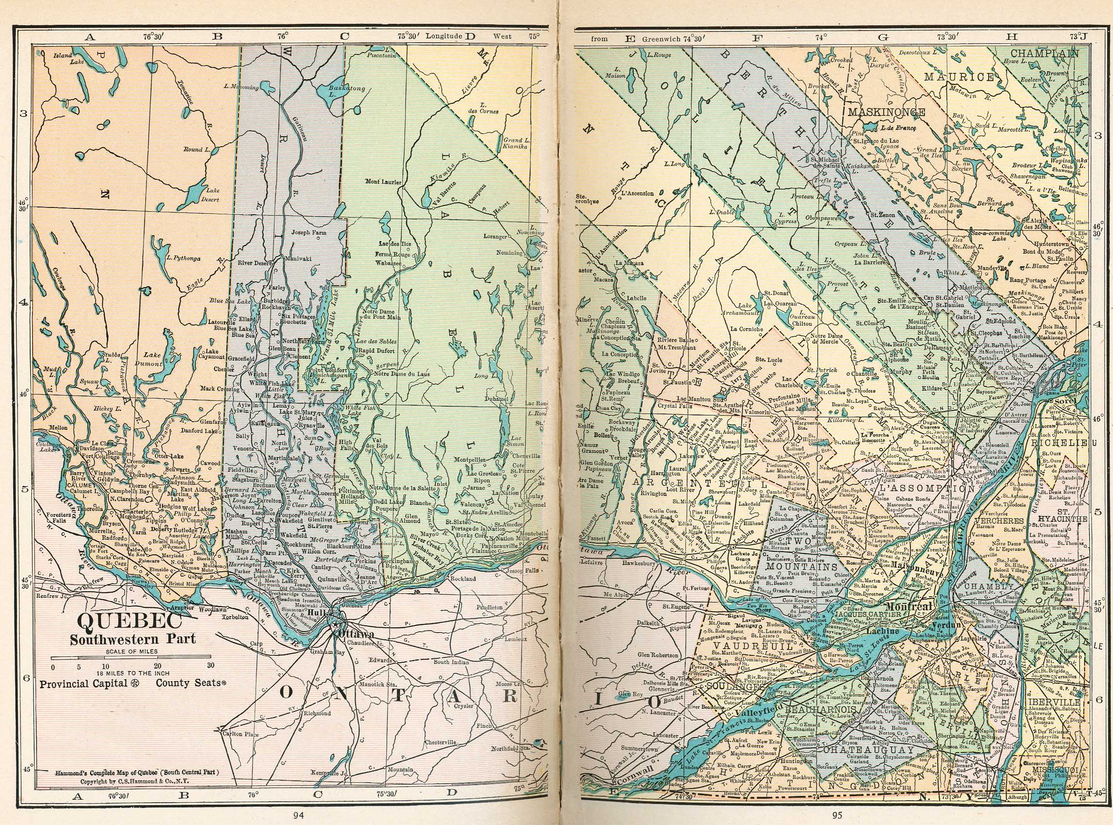
- Quebec - Southwestern Part 1921 (1005K)
- From Putnam's Handy Volume Atlas of the World. Published by G.P. Putnam's Sons, New York and London, 1921.
- Relaciones Geográficas [1578-1586]
- This is an exhibit of eleven maps from the holdings of the Benson Latin American Collection. The maps serve as primary sources of information about the Spanish conquest of Middle America.
- Rio De Janeiro, Brazil 1882 (182K)
- "Rio De Janeiro Harbour" from A Dictionary Practical, Theoretical, and Historical of Commerce and Commercial Navigation by J.R. M'Culloch. Longmans, Green and Co. London, 1882.
- Rio de Janeiro 1928 - Sheet 1 (19.1MB), Sheet 2 (18.5MB) and Both Sheets (37.4MB)
- Planta da Cidade do Rio de Janeiro. Organisada na Carta Cadastral. [Rio de Janeiro] : Directoria Geral de Obras y Via��o, Prefeitura do Districto Federal, 1928
- Rio Grande, Roma to the Gulf of Mexico 1910-1911
- Maps from Survey of the Rio Grande, Roma to the Gulf of Mexico : Reports and Maps.
Proceedings of the International Boundary Commission, United States and Mexico : American Section :
Joint Report of the Consulting Engineers on Field Operations of 1910-1911. U.S. Department of State [1913].
- St. John, New Brunswick 1894 (242K)
- "St. John" from Baedeker, Karl. The Dominion of Canada with Newfoundland and an Excursion to Alaska. Leipsic, 1894.
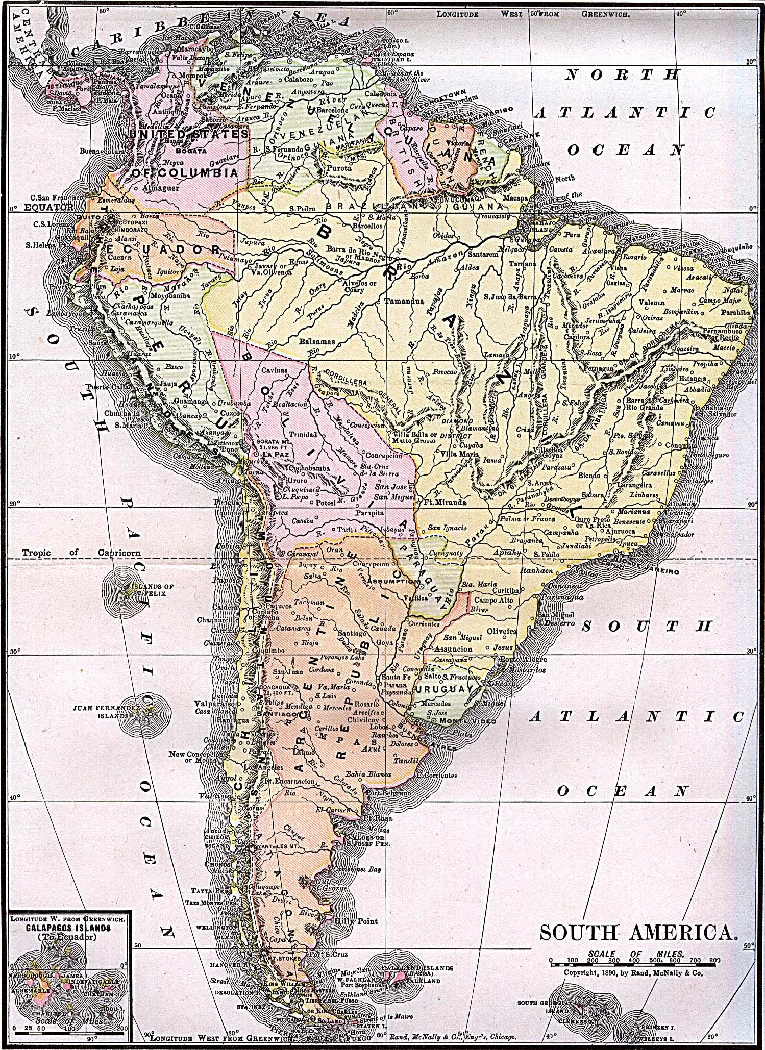
- South America 1892 (1MB)
- "South America" from "Americanized Encyclopaedia Britannica", Vol. 1, Chicago 1892.
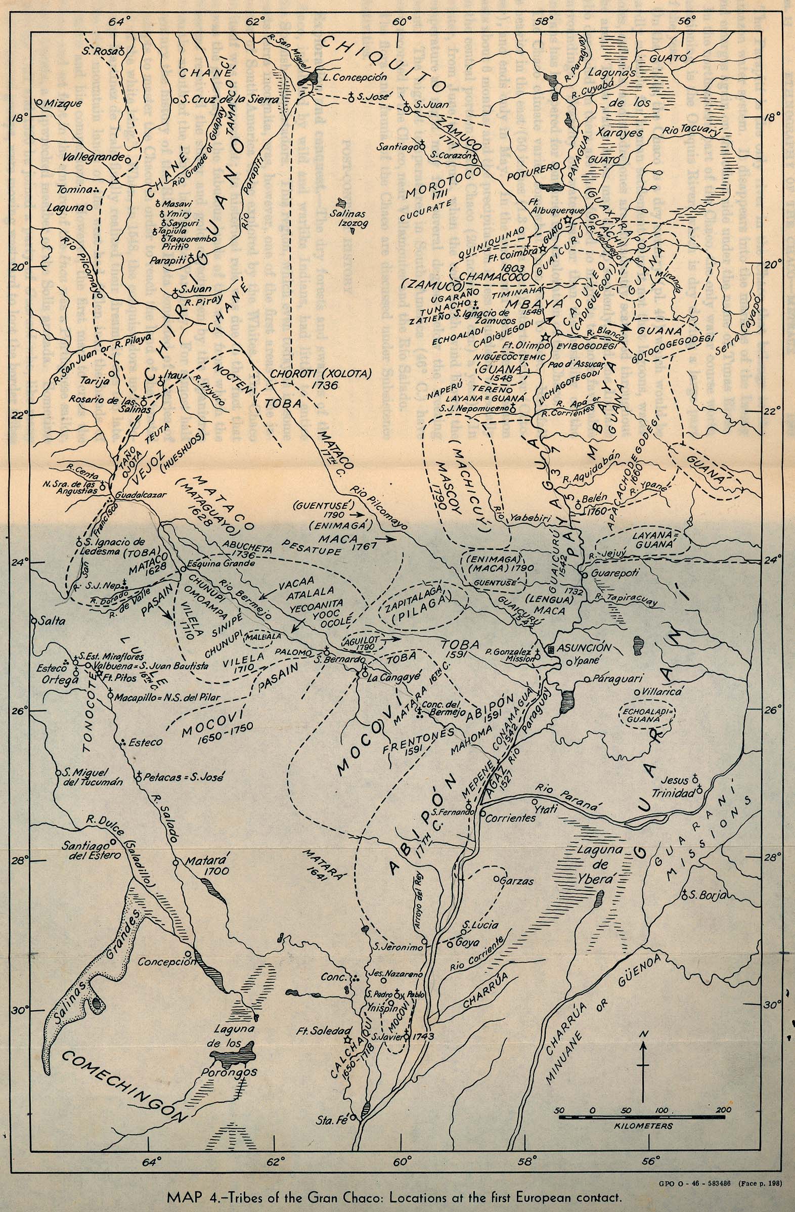
- South America - Gran Chaco Tribes 1946 (670K)
- "Tribes of the Gran Chaco: Locations at the first European contact." From Handbook of South American Indians. Volume 1 The Marginal Tribes. Edited by Julian H. Steward. Smithsonian Institution Bureau of American Ethnology, 1946.
- South America - Gran Chaco Tribes 1946 (492K)
- "Tribes of the Gran Chaco: Present day locations." From Handbook of South American Indians. Volume 1 The Marginal Tribes. Edited by Julian H. Steward. Smithsonian Institution Bureau of American Ethnology, 1946.
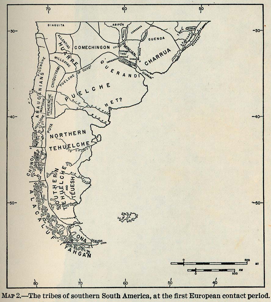
- South America - Tribes 1946 (177K)
- "Tribes of Southern South America, at the first European contact period." From Handbook of South American Indians. Volume 1 The Marginal Tribes. Edited by Julian H. Steward. Smithsonian Institution Bureau of American Ethnology, 1946.
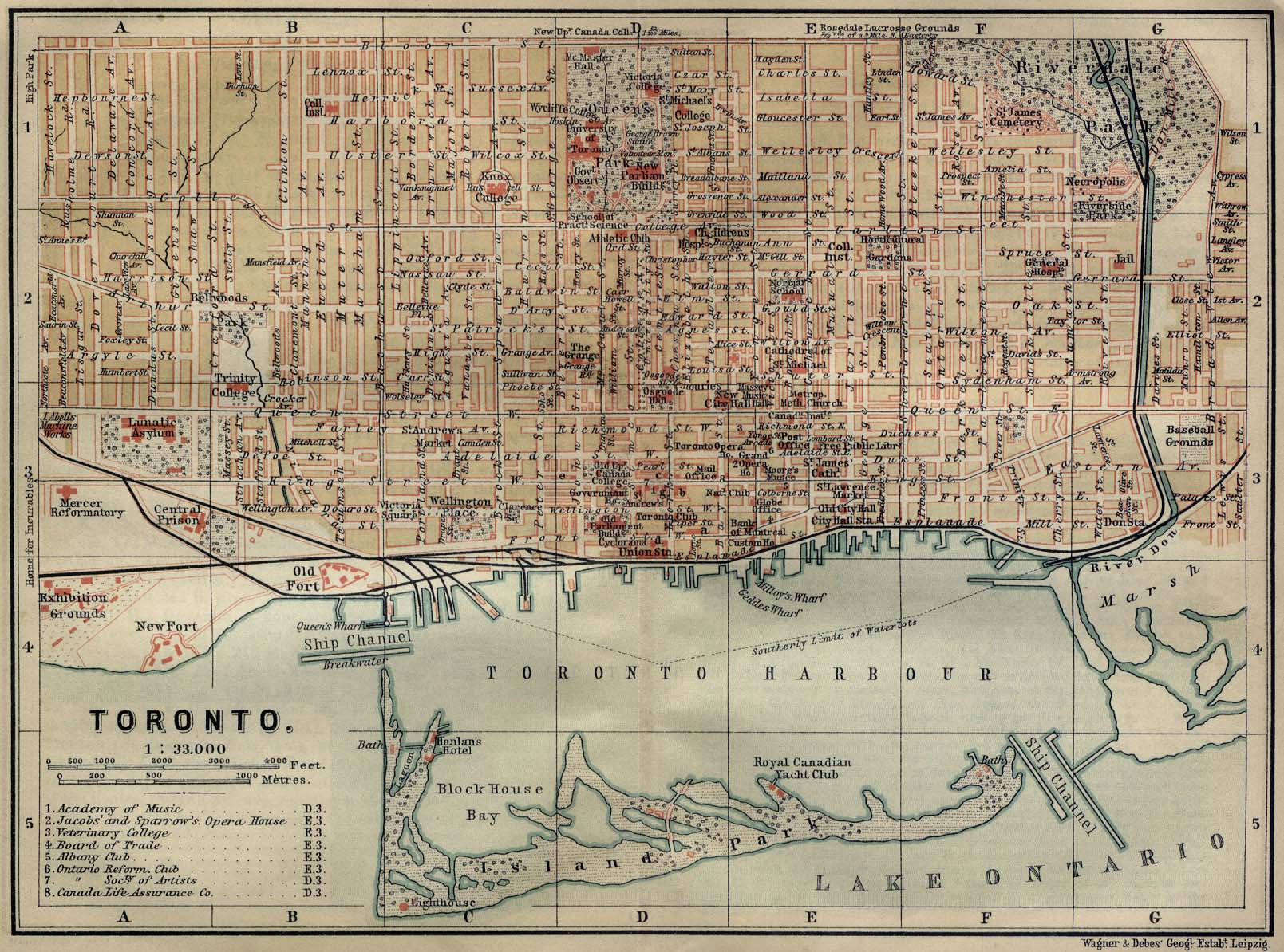
- Toronto 1894 (397K)
- "Toronto" from Baedeker, Karl. The Dominion of Canada with Newfoundland and an Excursion to Alaska. Leipsic, 1894.
- United States Historical Maps
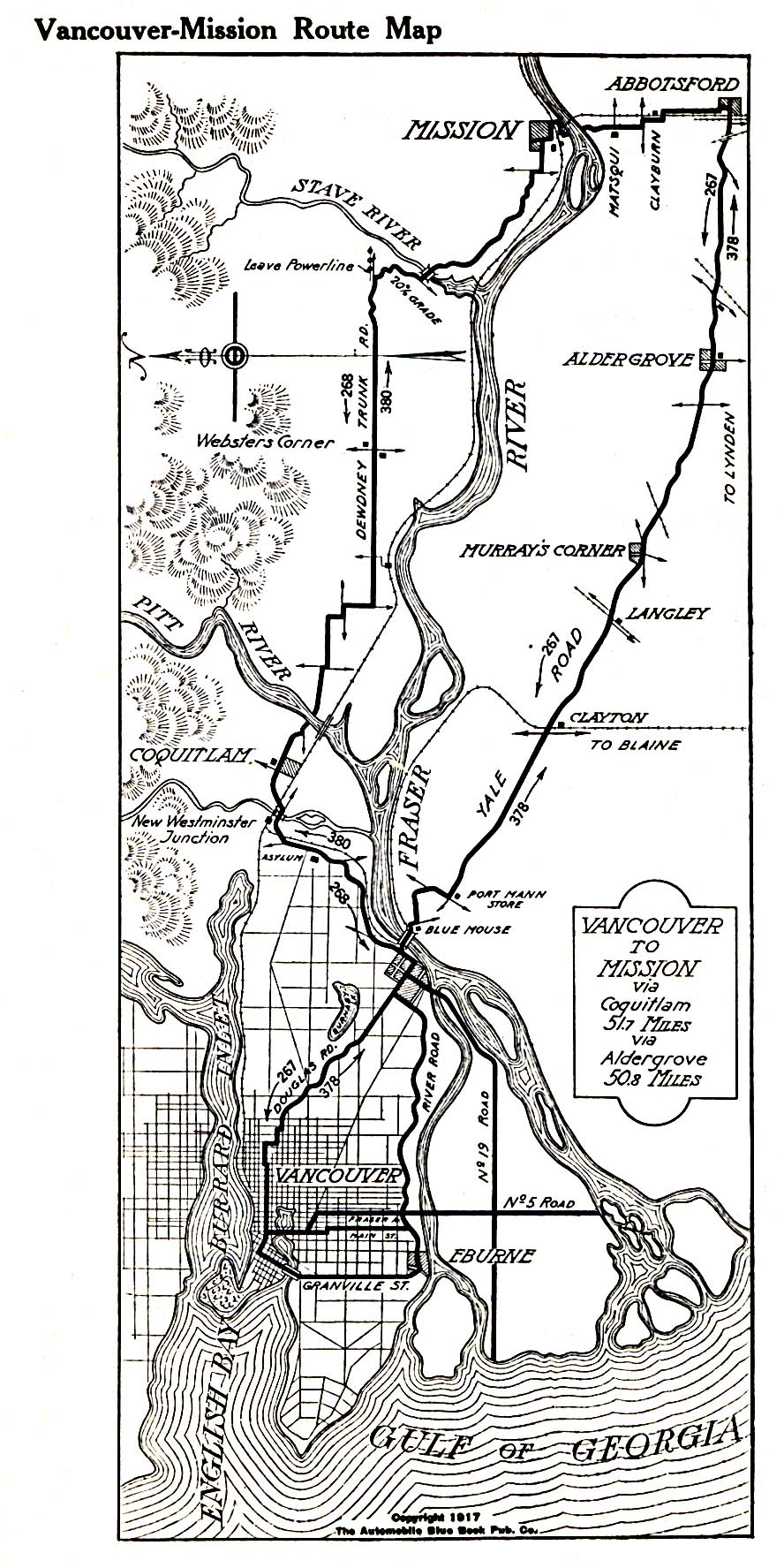
- Vancouver-Mission Route Map 1917 (452K)
- From The Automobile Blue Book, 1917.
- [Veracruz] Siege of Vera Cruz 1847 (2MB)
- "Siege of Vera Cruz, by the U.S. Troops under Major General Scott, in March 1847..." United States. Army. Corps of Topographical Engineers. Turnbull, William, et. al. Map courtesy Dorothy Sloan-Rare Books Austin, Texas
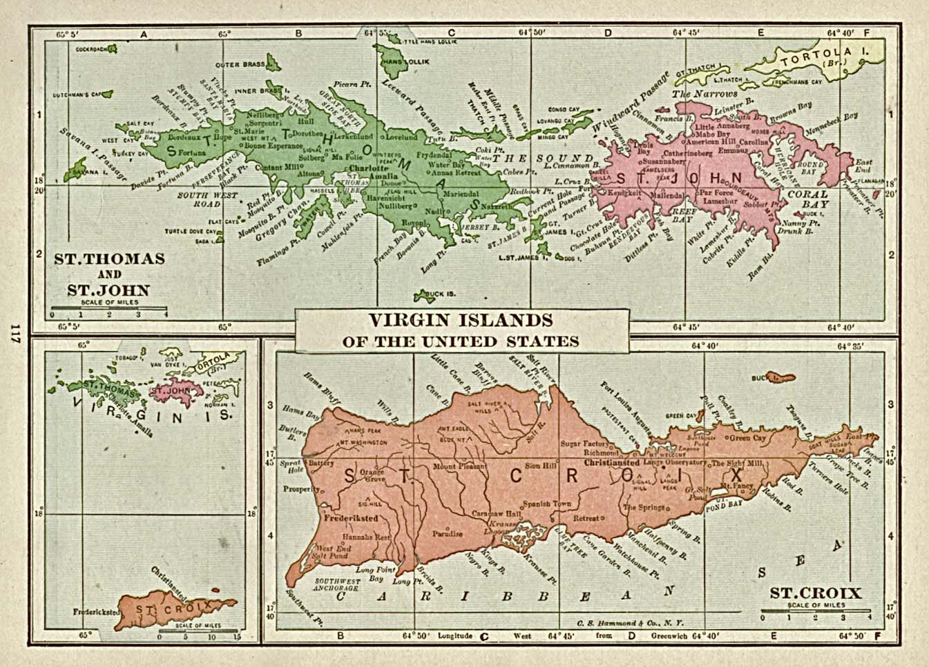
- Virgin Islands 1920 (323K)
- "Virgin Islands of the United States" from Putnam's Handy Volume Atlas of the World, 1921.
![Bahia (Bay of all Saints) 1882 [Brazil]](bahia_bay_1882.jpg)
![Anegada 1832 [British Virgin Islands]](anegada.jpg)
![Brasile Orientale 1899 [Brazil]](brasile_1899.jpg)
![Fraser River [British Columbia] 1859](fraser_river_bc_1859.jpg)
![[Mexico] Passage by Land to California 1731](http://maps.lib.utexas.edu/maps/historical/kino_passage_to_california-1731.jpg)
![North America - Air Control and Warning System [DEW, Mid-Canada, and Pinetree Lines] 1960](dew_line_1960.jpg)
![[North America - Southwest] 1841](http://maps.lib.utexas.edu/maps/historical/scherpf-rio_grande-1841.jpg)
![Peel River [Northwest Territories/Yukon] 1845](peel_river_1845.jpg)
![Porto Rico [Puerto Rico], 1920](porto_rico_1920.jpg)
![Quebec [City], Canada 1894](quebec_1894.jpg)
![[Veracruz] Siege of Vera Cruz 1847](http://maps.lib.utexas.edu/maps/historical/us_army-vera_cruz-1847.jpg)