Perry-Castañeda Library
Map Collection
Maps Relating to September 11, 2001 and Later Events
-
Attack on The World Trade Center:
- Below Ground Zero (The Washington Post)
- Citywide Response (The New York Times)
- International Toll of September 11, 2001 (U.S. Department of State)
- Ruins of the World Trade Center - Aerial Photographs (GlobalSecurity)
- World Trade Center Complex (The Washington Post)
- World Trade Center Location Map (The Washington Post)
- Lower Manhattan Building Status (CNN)
- Lower Manhattan Pedestrian and Vehicle Restrictions (City of New York/Web Archive)
- Lower Manhattan with a Detail of The World Trade Center (The Washington Post)
- One Year Viewed from Space (Space Imaging/Internet Archive)
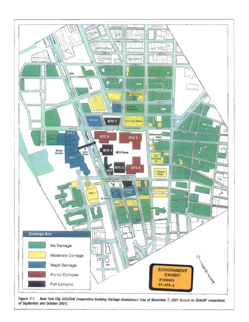
- World Trade Center - Diagram Depicting the Damage to the Buildings in the World Trade Center Area as a Result of the Attacks on September 11, 2001 Moussaoui trial, Exhibit GX-P200009 (introduced: 04/06/2006)
- World Trade Center Building Performance Study [overview maps in Chapter 1] (FEMA/GPO)
- World Trade Center Map (Wired New York/Internet Archive)
- Map of the World Trade Center area depicting the paths of Flights 11 and 175 Moussaoui trial, Exhibit GX-P200003 (introduced: 04/06/2006)
-
Attack on The Pentagon:
- Aerial Photograph of the Pentagon at 11:46 a.m. EDT on Sept. 12, 2001 (Maps.com)
- Aerial Photographs of Pentagon Damage (GlobalSecurity/Ikonos)
- Map of the Strike Against The Pentagon (The Washington Post)
- Road Closings Near The Pentagon (Washington Post)
- One Year Viewed from Space (Space Imaging/Internet Archive)
-
Hijacked Planes:
- Paths of Destruction (Time.com/Internet Archive)
- Pennsylvania Plane Crash Site (The Washington Post)
- Flight Paths of the Hijacked Planes (The Washington Post)
-
War in Afghanistan:
- War in Afghanistan - Maps (University of Texas at Austin)
-
Anthrax Attacks:
- Anthrax at Home (Washington Post) [Flash]
- Anthrax Cases (BBC News Online)
- Anthrax in America (CNN/Internet Archive)
- Washington, D.C. Area - Sites Where Anthrax Spores Have Been Found - November 5, 2001 (Washington Post)
-
Airliner Crash in New York City - November 12, 2001:
- New York Plane Crash Location Map (CNN/Internet Archive)