Perry-Castañeda Library
Map Collection
Somalia Maps
The following maps were produced by the U.S. Central Intelligence Agency, unless otherwise indicated.
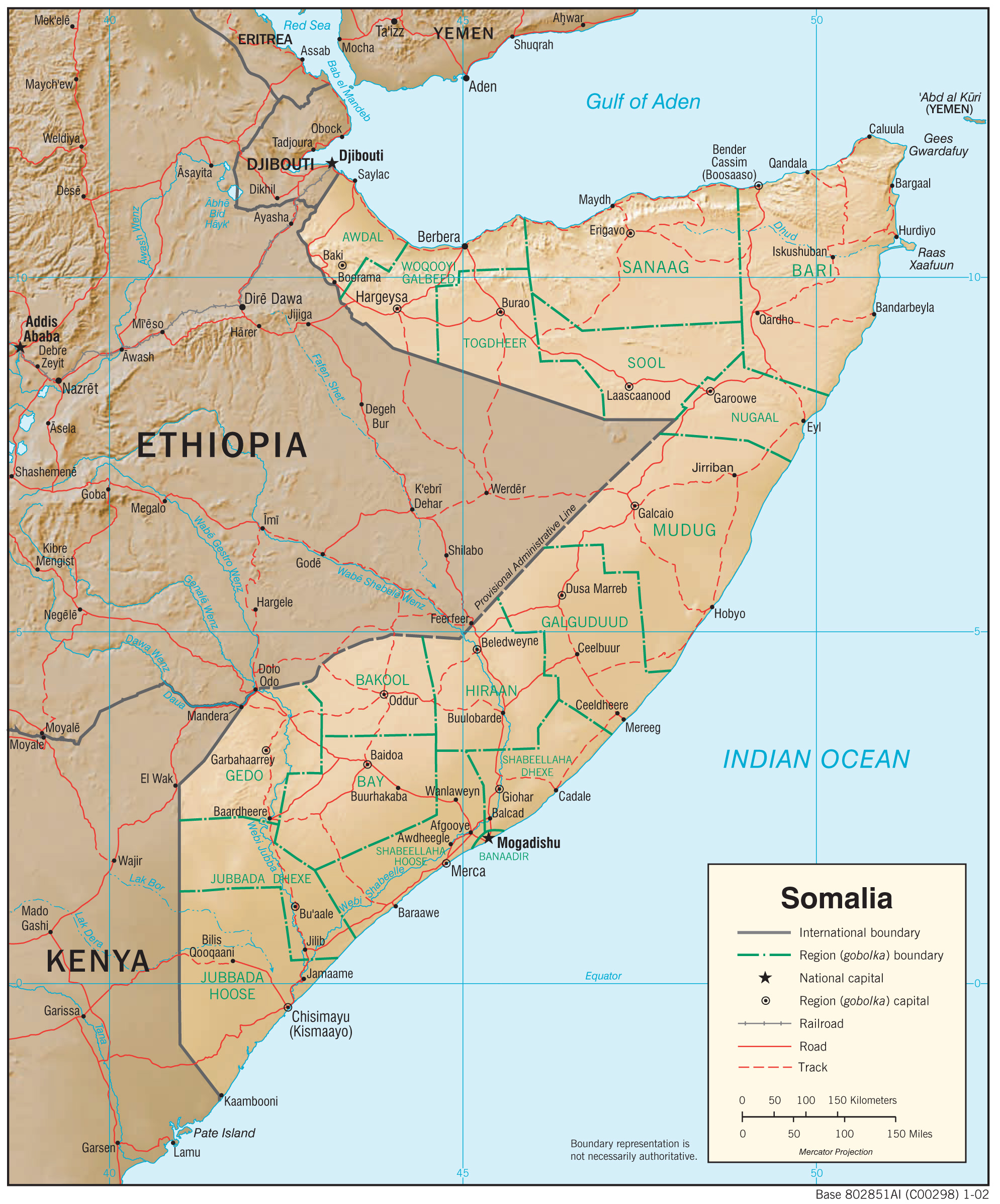
Country Maps- Somalia (Physiography) 2002 (1.3MB) and pdf format (1.2MB)
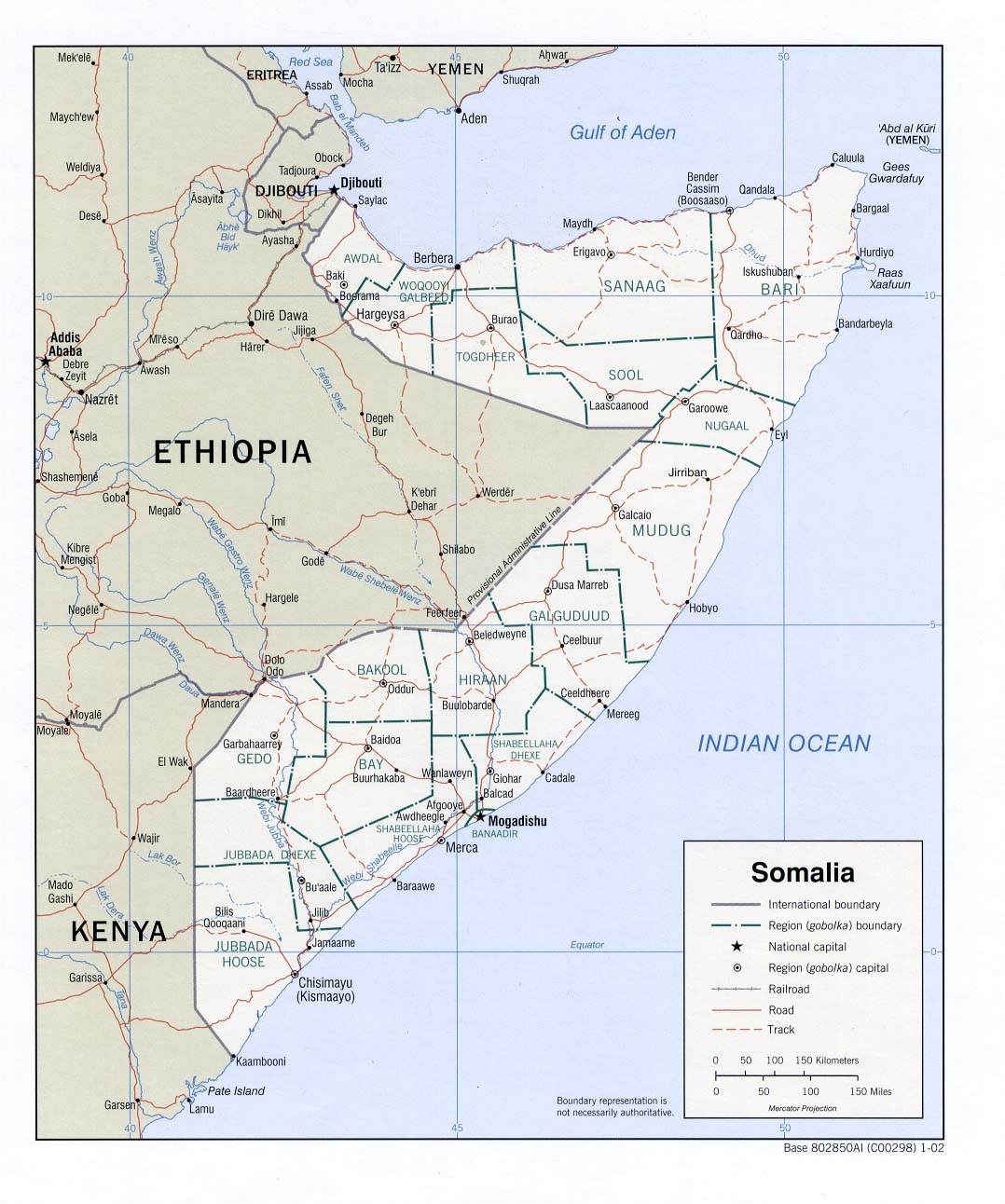
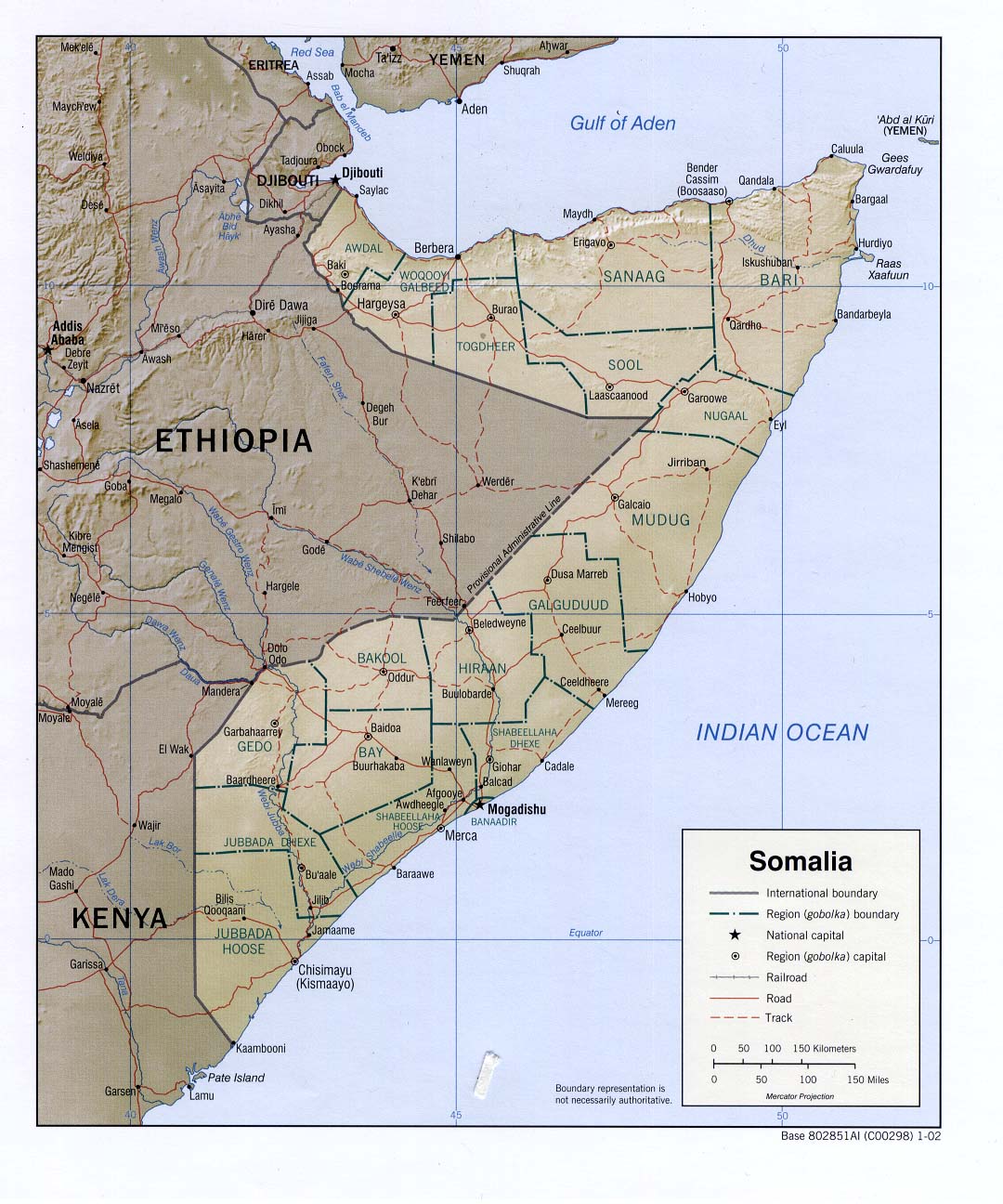
- Somalia (Political) 2002 (203K) and pdf format (210K)
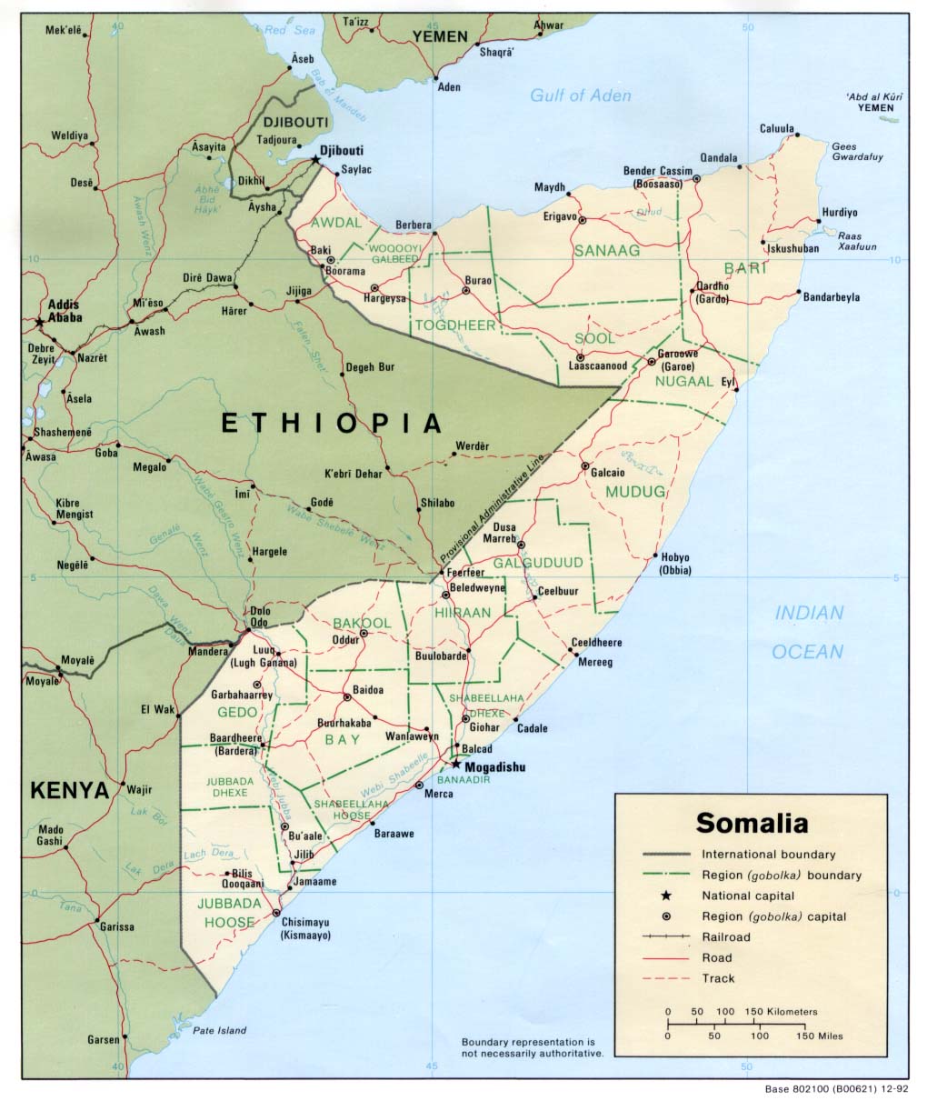
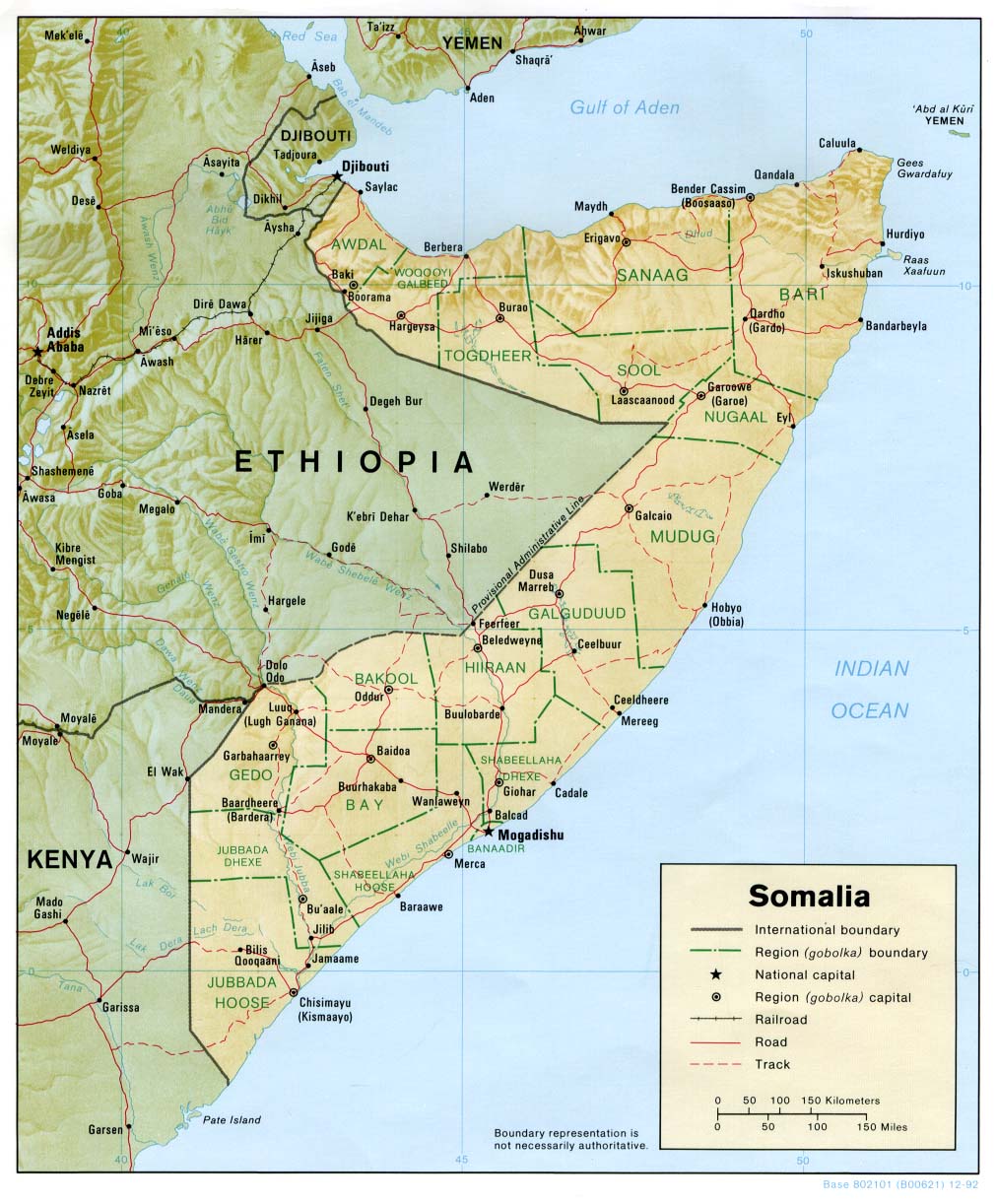
- Somalia (Political) 1992 (162K) and pdf format (170K)
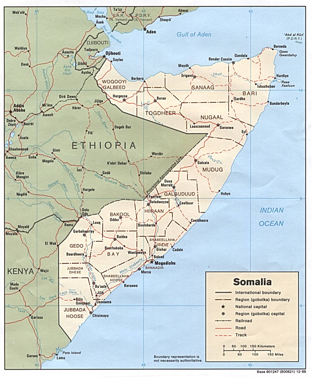
- Somalia (Political) 1988 (213K) and pdf format (217K)
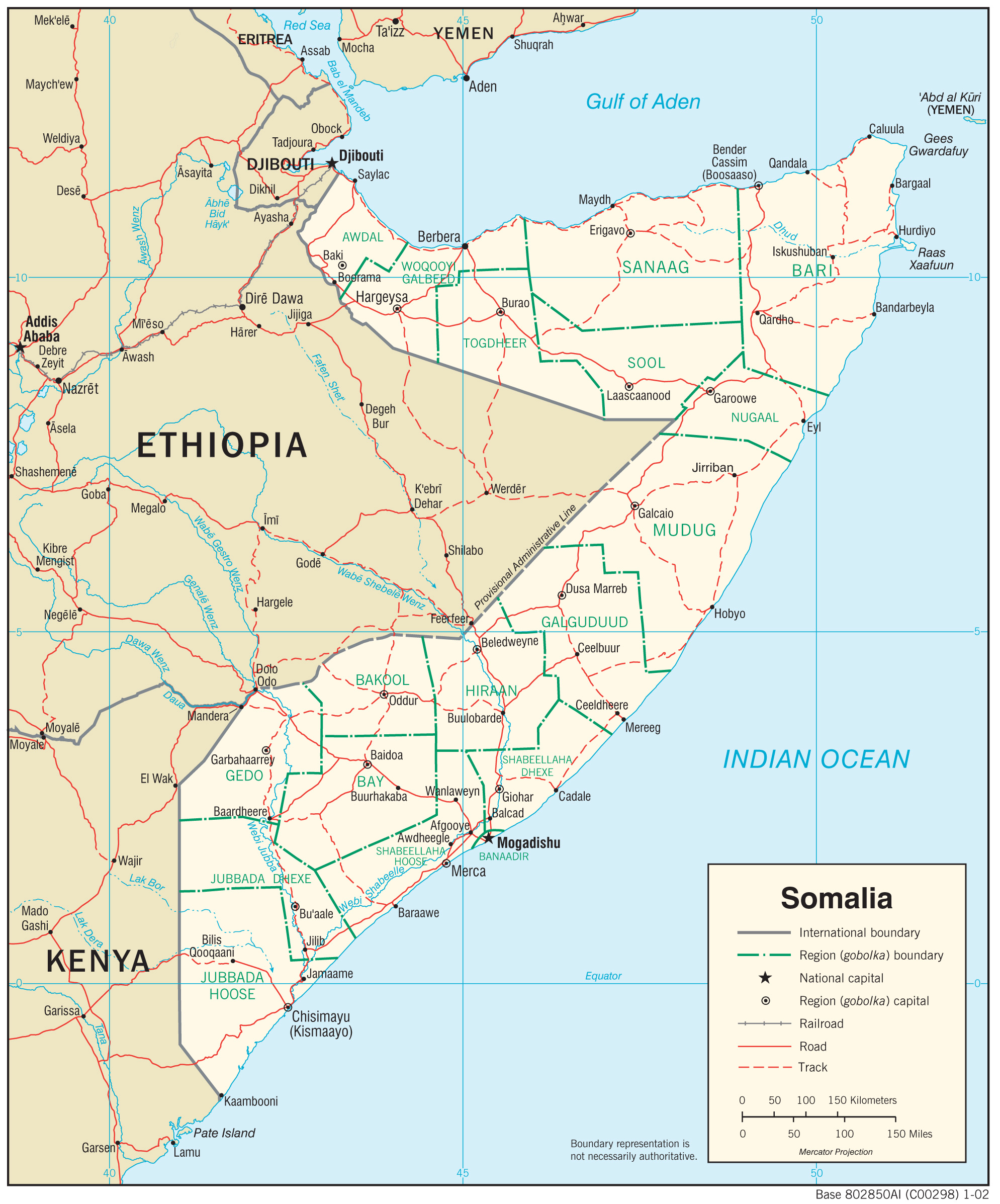
- Somalia (Shaded Relief) 2002 (206K) and pdf format (250K)
- Somalia (Shaded Relief) 1992 (206K) and pdf format (212K)
- Somalia (Small Map) 2016 (19.4K)
- Somalia (Transportation) 2002 (1.2MB) and pdf format (1.8MB)
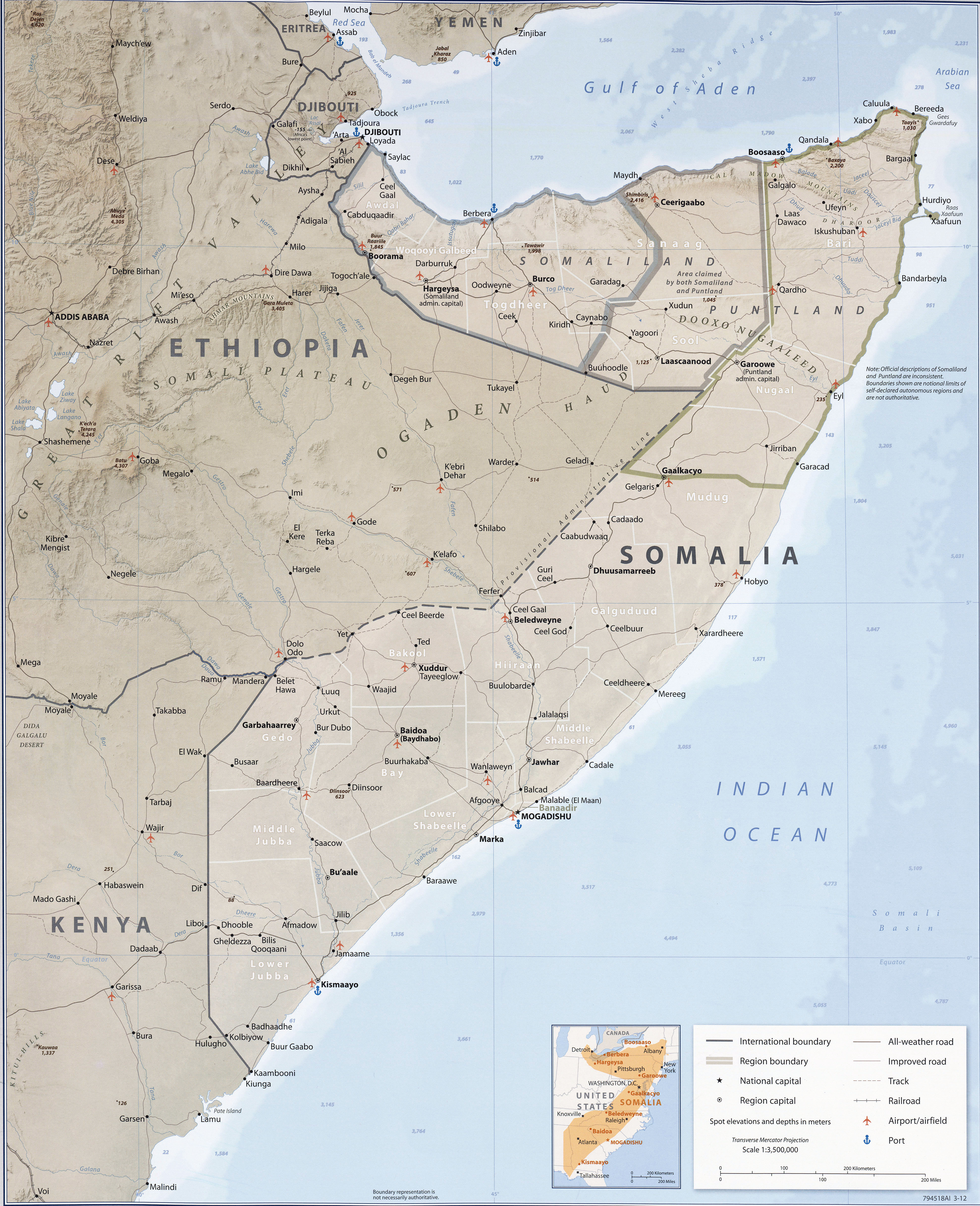
- Somalia Country Profile 2012 (Wall Map) (3.3MB)
- Somalia From Somalia Country Profile, 2012 (2.9MB)
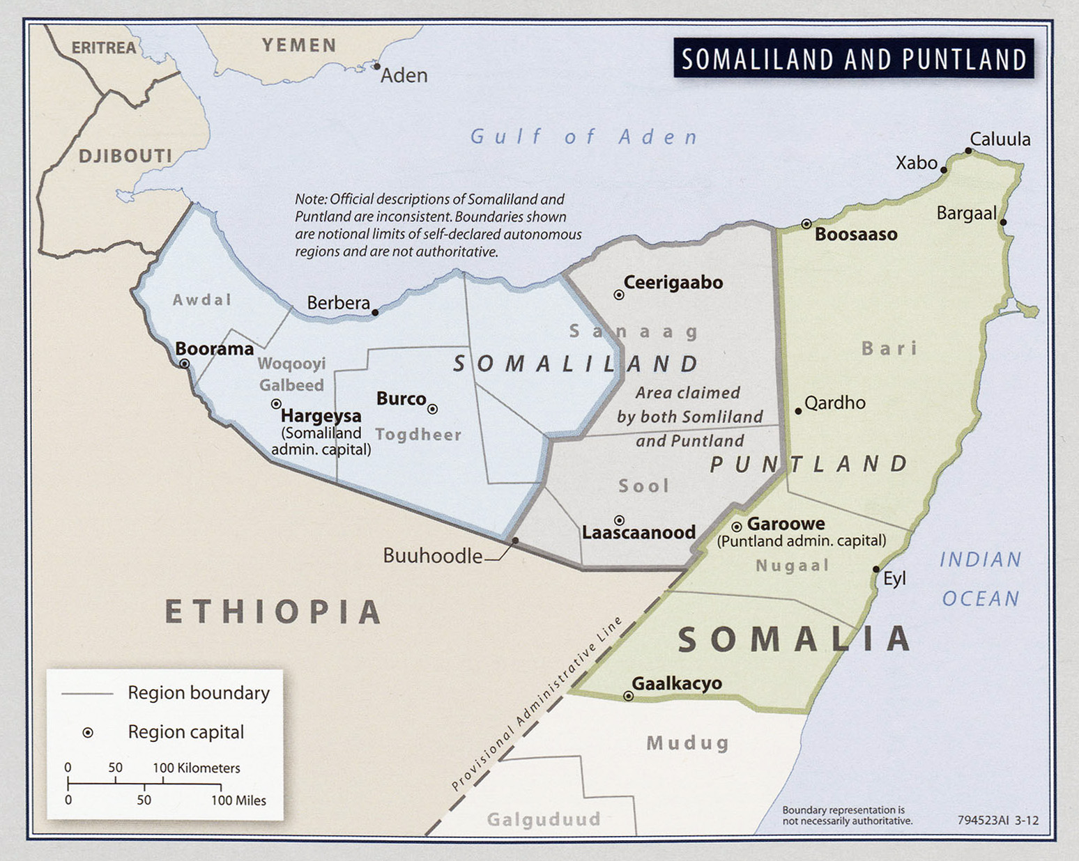
- Somaliland and Puntland From Somalia Country Profile, 2012 (516K)
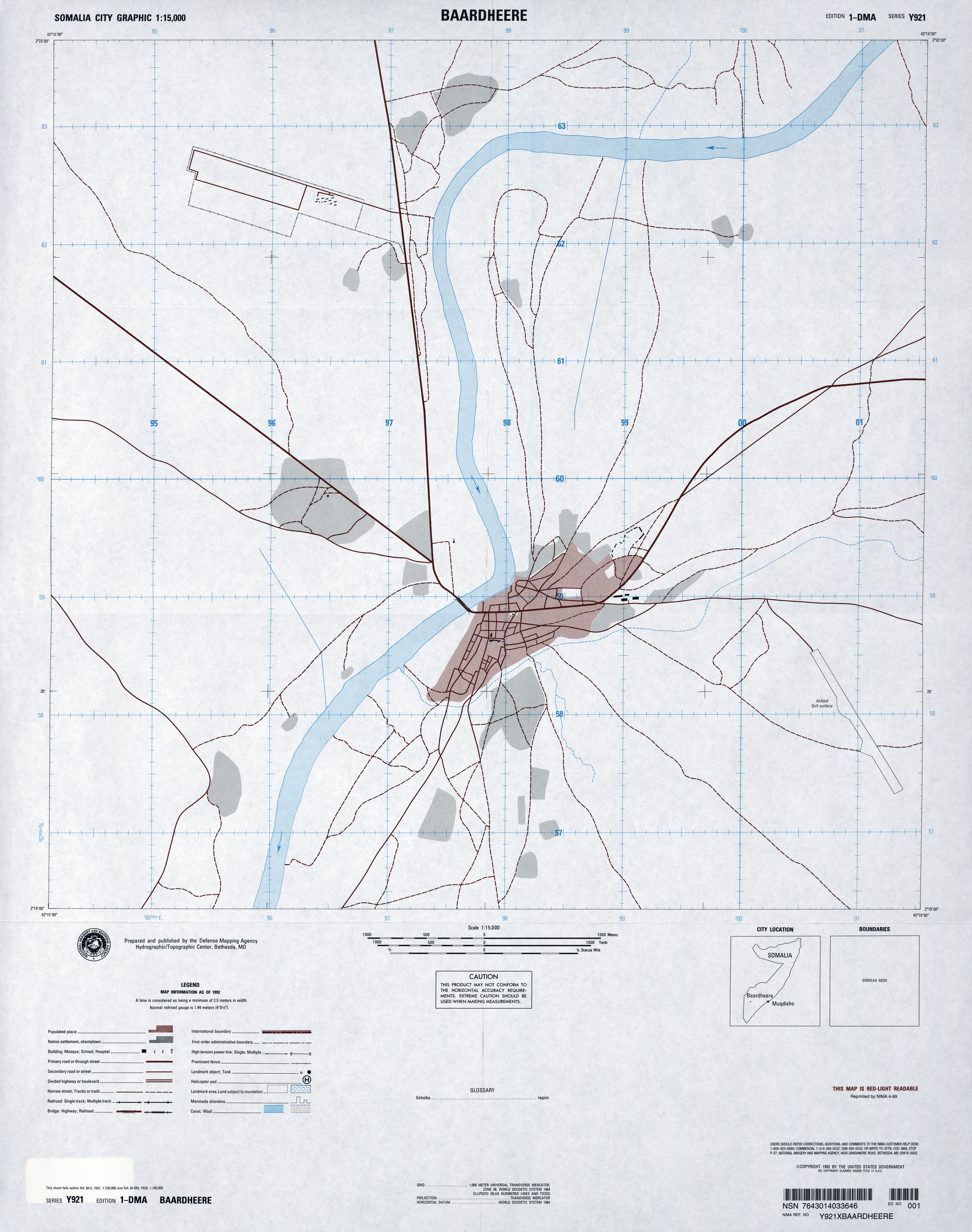
- Baardheere 1:15,000, Edition 1-DMA, Series Y921. U.S. Defense Mapping Agency, 1992 (3.6MB)
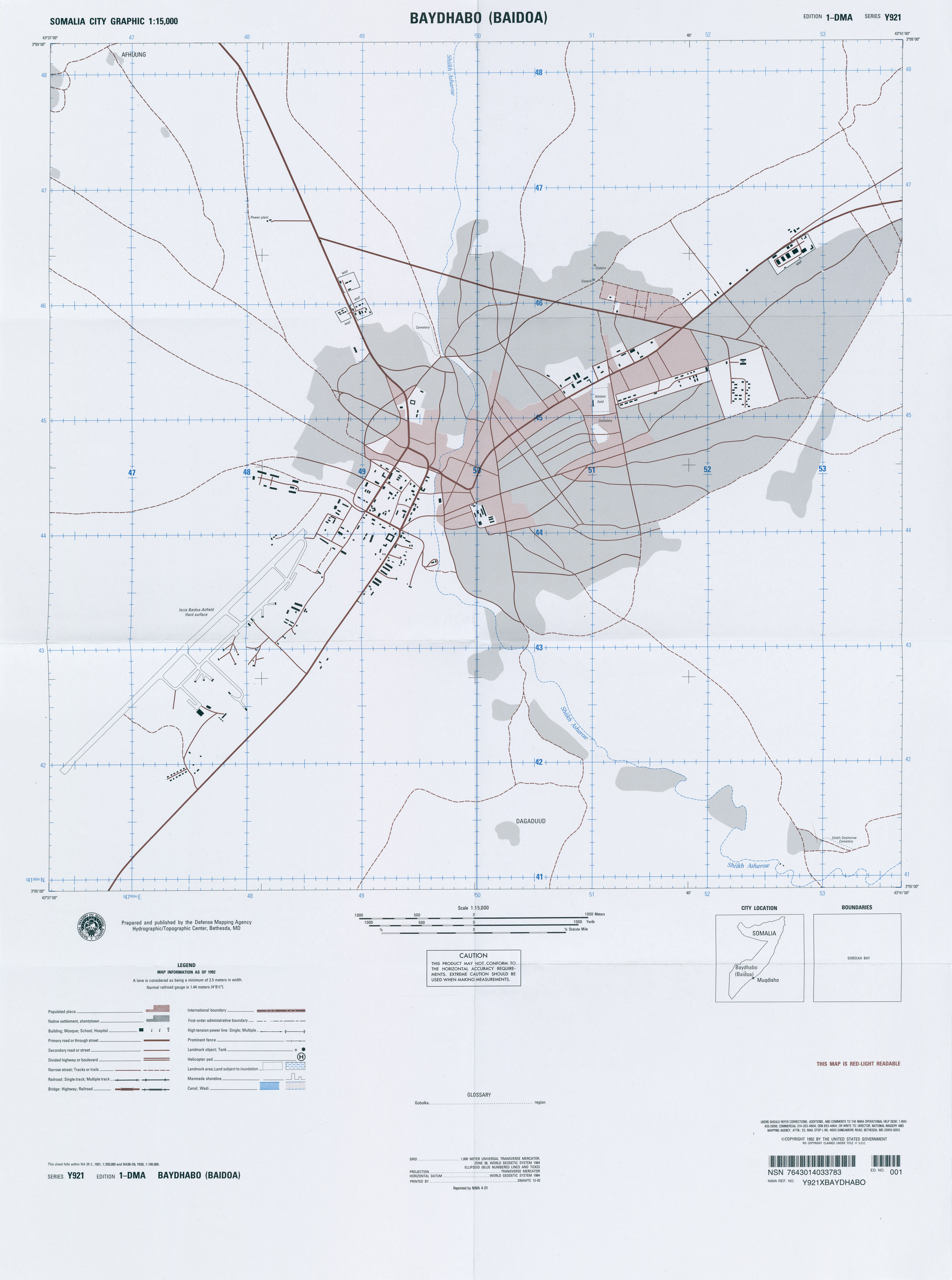
- Baydhabo (Baidoa) Series Y921, Edition 1-DMA, Somalia City Graphic, Original scale 1:15,000, U.S. National Imagery and Mapping Agency, 1992, reprinted 2001 (1.3MB)
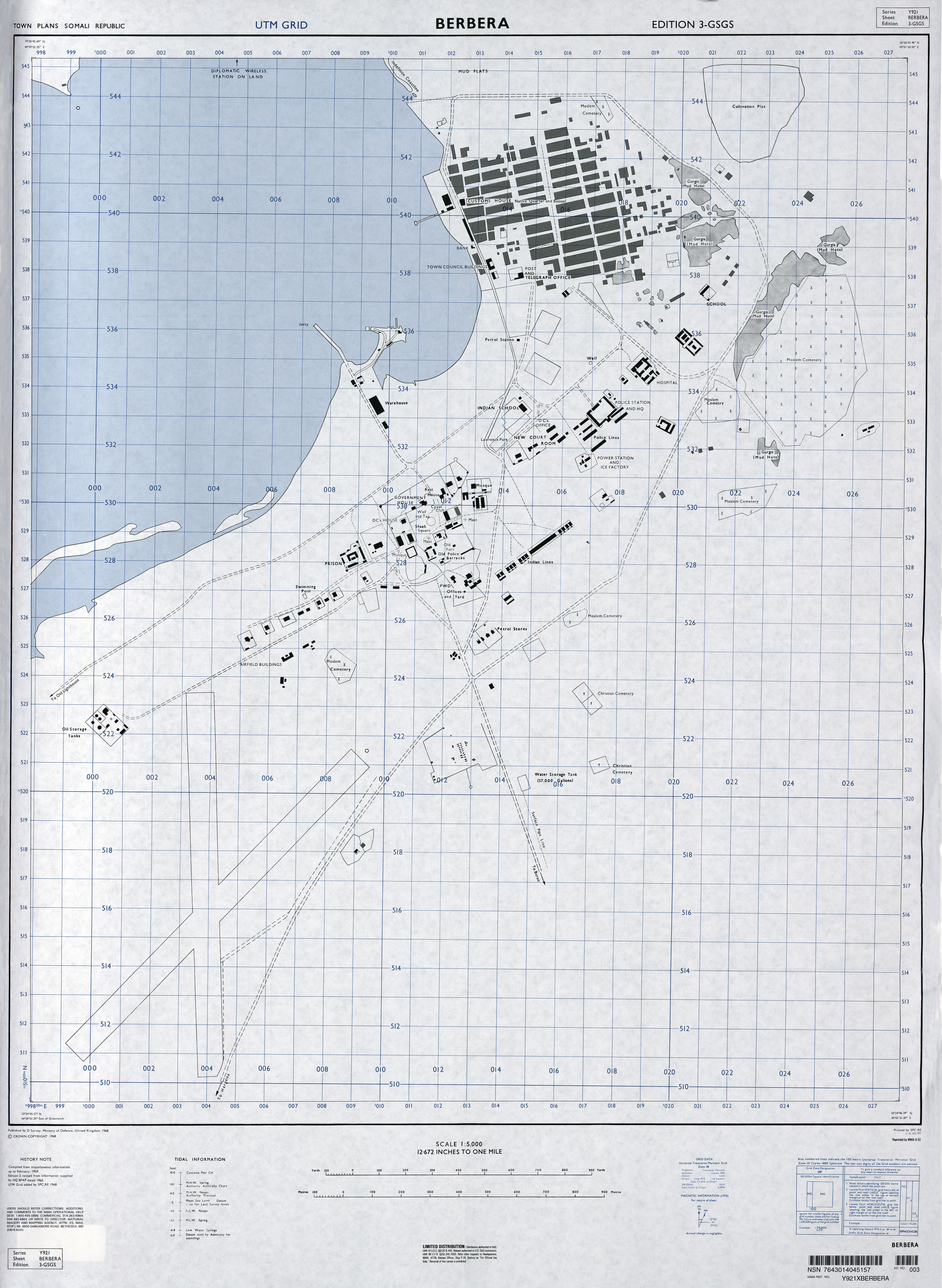
- Berbera 1:5,000, Edition 3-GSGS, Series Y921. National Imagery and Mapping Agency, 1968 (2.9MB)
- Boosaaso [Bender Cassim] 1:15,000, Edition 1-DMA, Series Y921. U.S. Defense Mapping Agency, 1992 (10MB)
- Caluula [Alula] 1:12,500, Edition 1-DMA, Series Y921. U.S. Defense Mapping Agency, 1983 (5.2MB)
- Dhuusamarreeb [Dusa Marreb] 1:15,000, Edition 1-DMA, Series Y921. U.S. Defense Mapping Agency, 1990 (2.5MB)
- Gaalkacyo [Galcaio] 1:15,000, Edition 1-DMA, Series Y921. U.S. Defense Mapping Agency, 1992 (6.7MB)
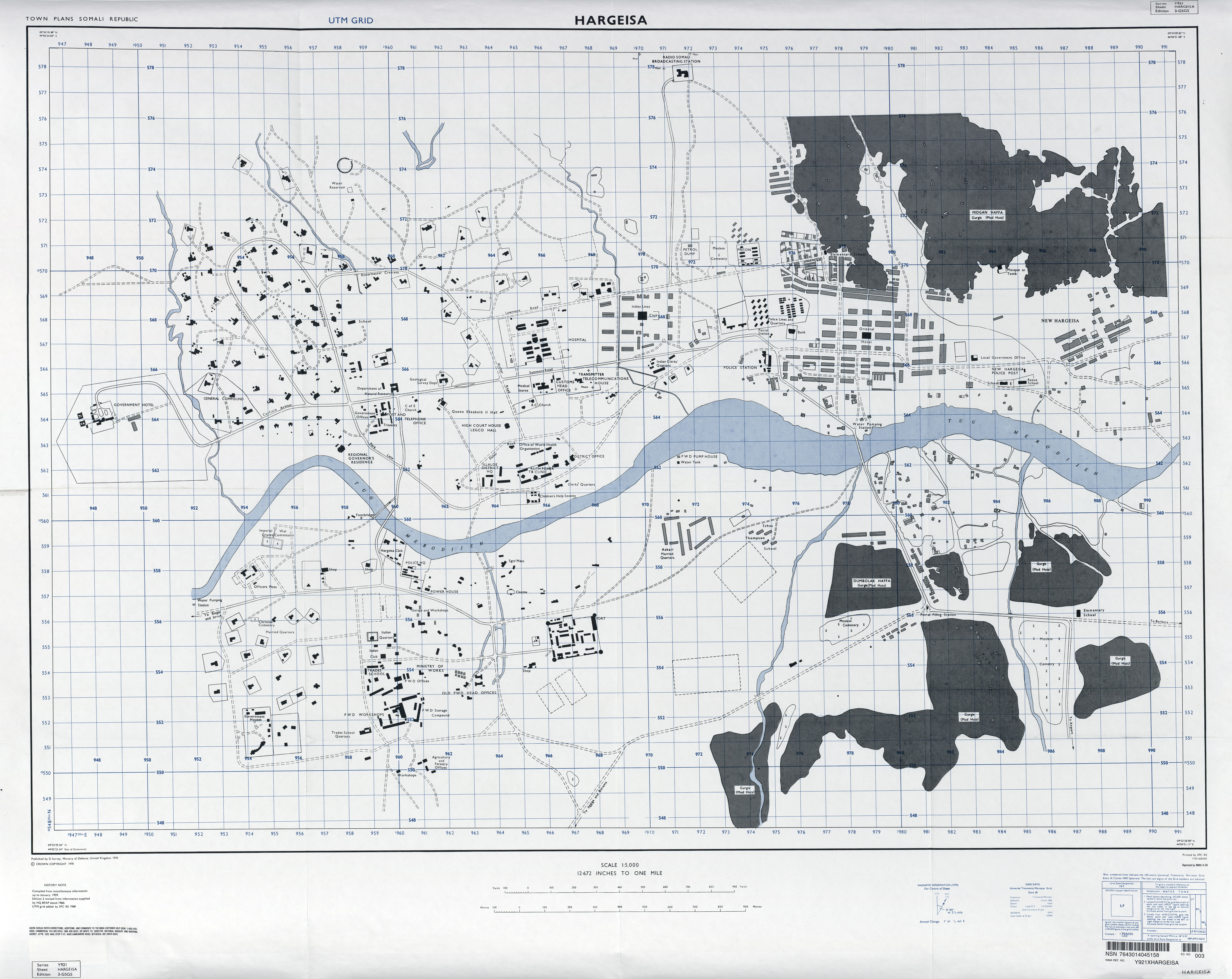
- Hargeisa 1:5,000, Edition 3-GSGS, Series Y921. National Imagery and Mapping Agency, 1968 (4MB)
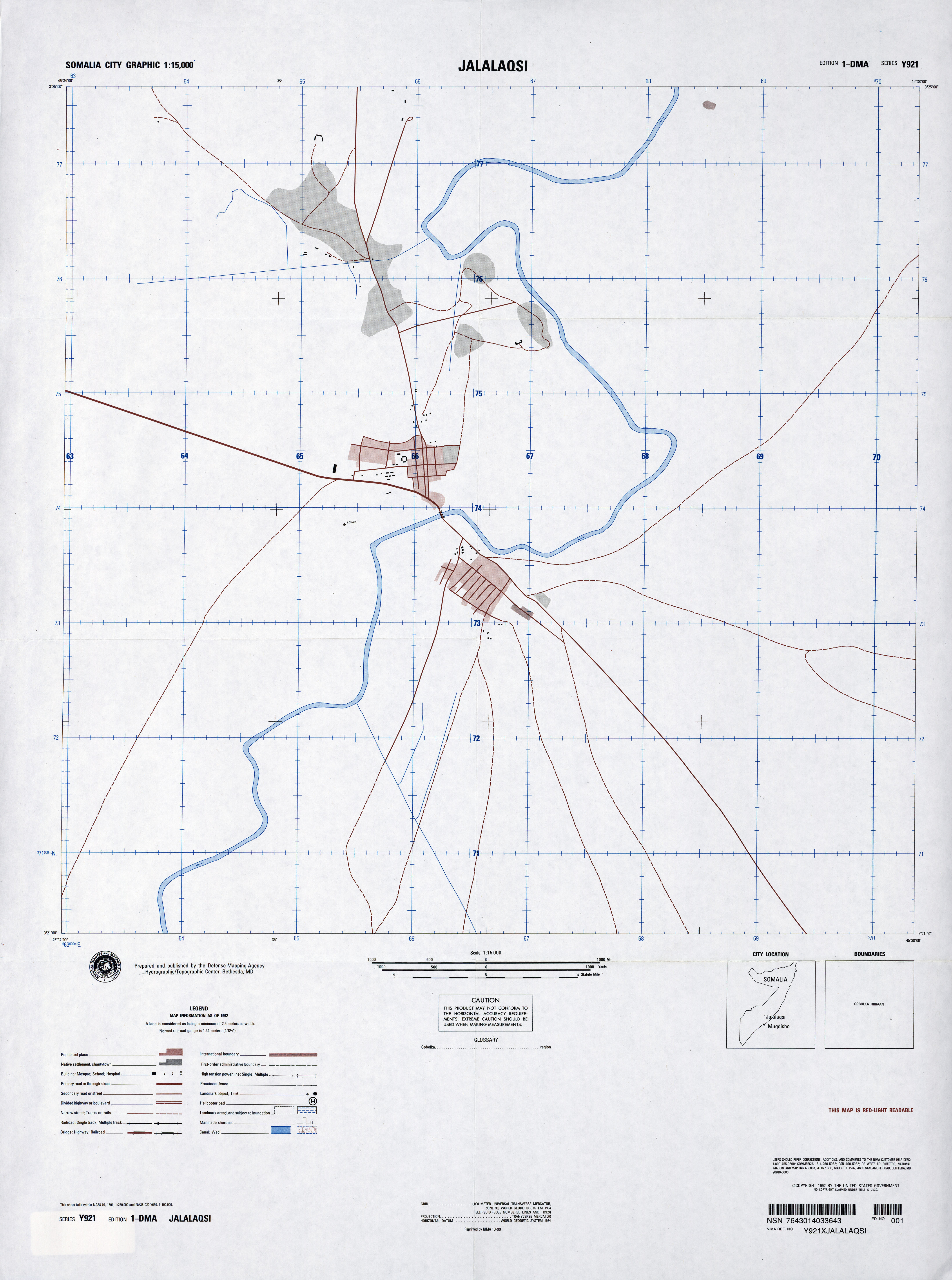
- Jalalaqsi 1:15,000, Edition 1-DMA, Series Y921. U.S. Defense Mapping Agency, 1992 (3MB)
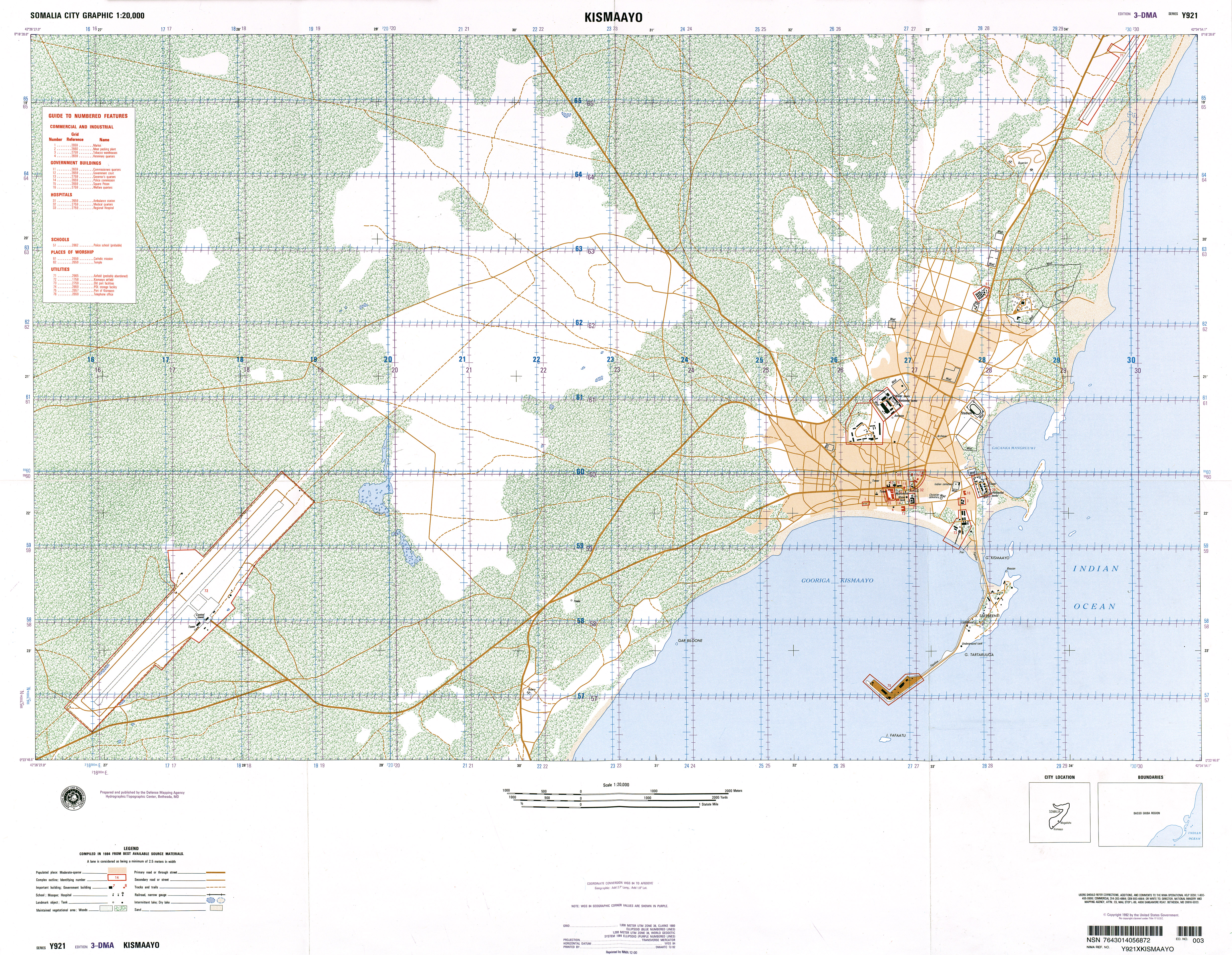
- Kismaayo Series Y921, Edition 3-DMA, Somalia City Graphic, Original scale 1:20,000, U.S. National Imagery and Mapping Agency, compiled 1984, published 1992, reprinted 2000 (9.8MB)
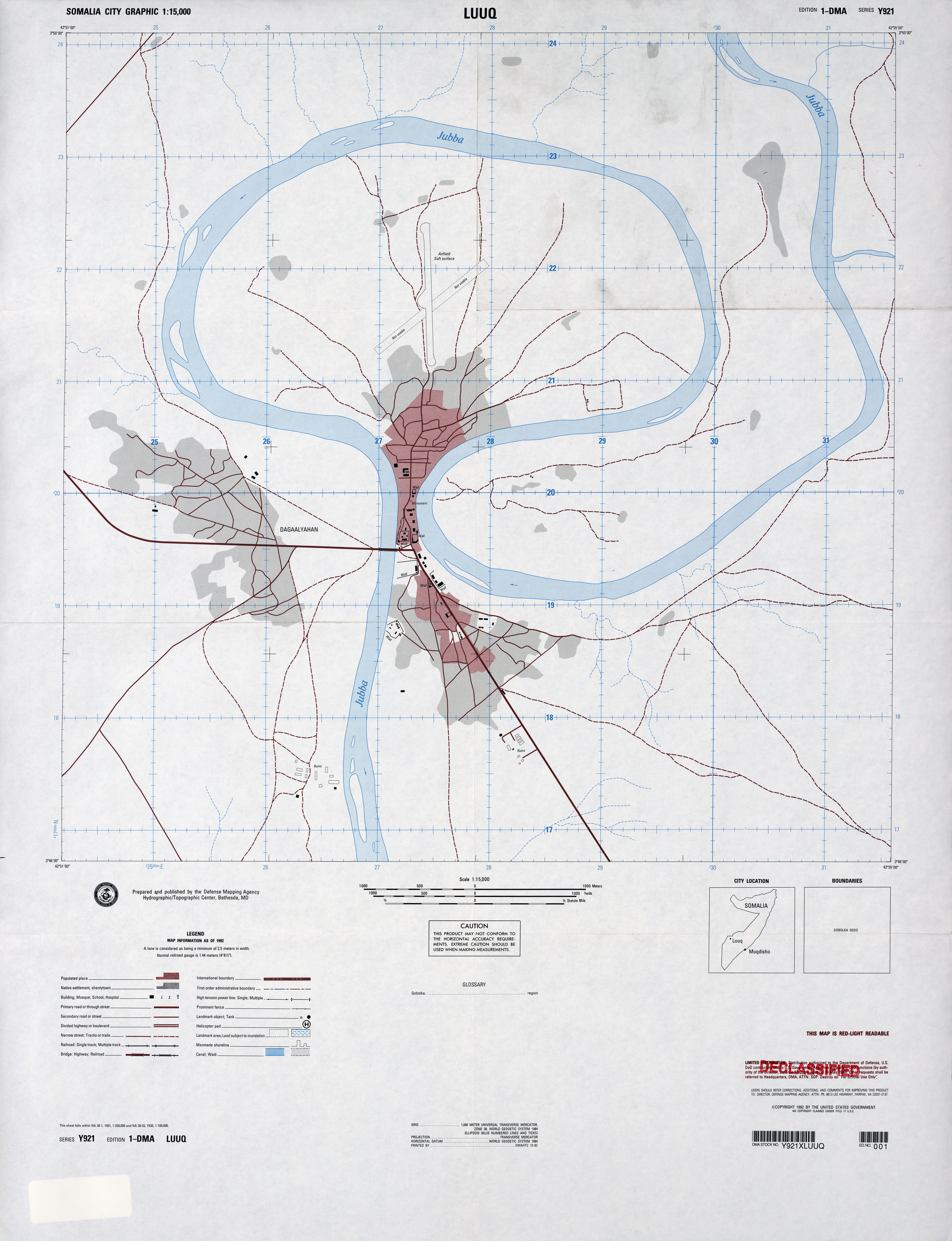
- Luuq 1:15,000, Edition 1-DMA, Series Y921. U.S. Defense Mapping Agency, 1992 (6.8MB)
- Marka [Merka] 1:15,000, Edition 1-DMA, Series Y921. U.S. Defense Mapping Agency, 1992 (4.1MB)
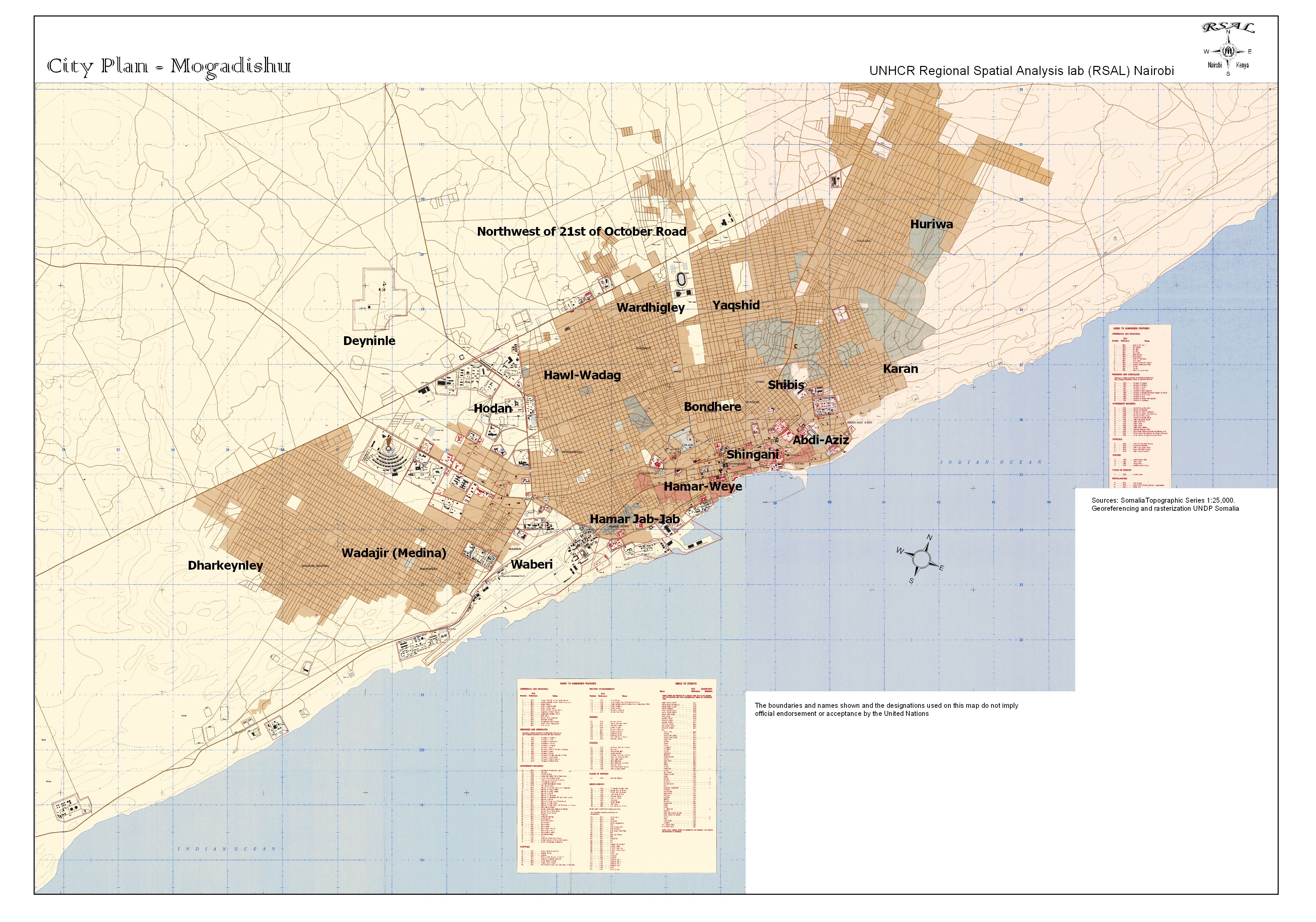
- [Mogadishu] City Plan Portion of sheet NA-38-67, Original scale 1:200,000, U.S. Defense Mapping Agency, 1992 (586K)
- [Mogadishu] Neighborhoods of Mogadishu From Somalia Country Profile, 2012 (531K)
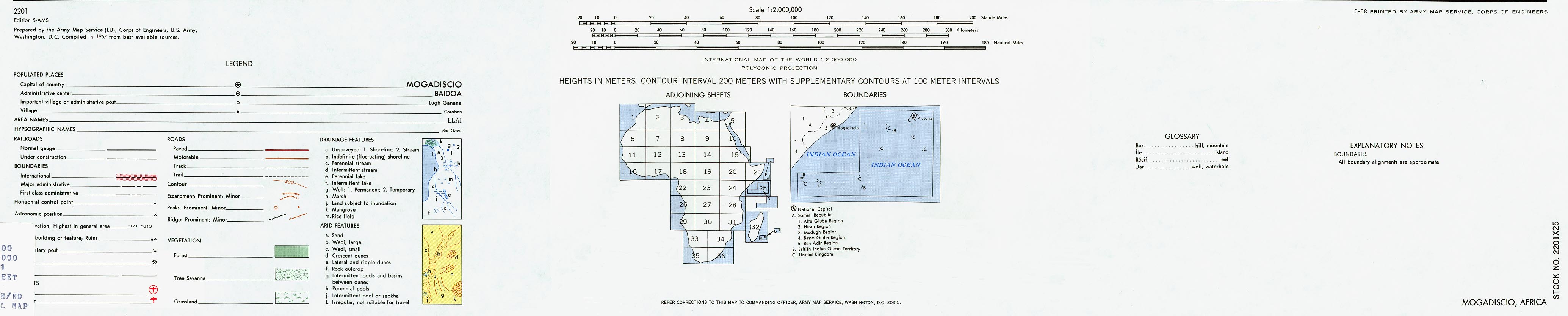
- [Mogadishu] Mogadiscio Region (1MB) and map key and scale (354K) Portion of AMS Series 2201, Sheet 25 "Mogadiscio", Original scale 1:2,000,000, U.S. Army Map Service, 1968.
- [Mogadishu] Muqdisho, Sheet 1 1:12,500, Edition 6-DMA, Series Y921. U.S. Defense Mapping Agency, 1993 [small] (7.4MB)
- [Mogadishu] Muqdisho, Sheet 1 1:12,500, Edition 6-DMA, Series Y921. U.S. Defense Mapping Agency, 1993 (20MB)
- [Mogadishu] Muqdisho, Sheet 2 1:12,500, Edition 6-DMA, Series Y921. U.S. Defense Mapping Agency, 1993 [small] (4.9MB)
- [Mogadishu] Muqdisho, Sheet 2 1:12,500, Edition 6-DMA, Series Y921. U.S. Defense Mapping Agency, 1993 (23MB)
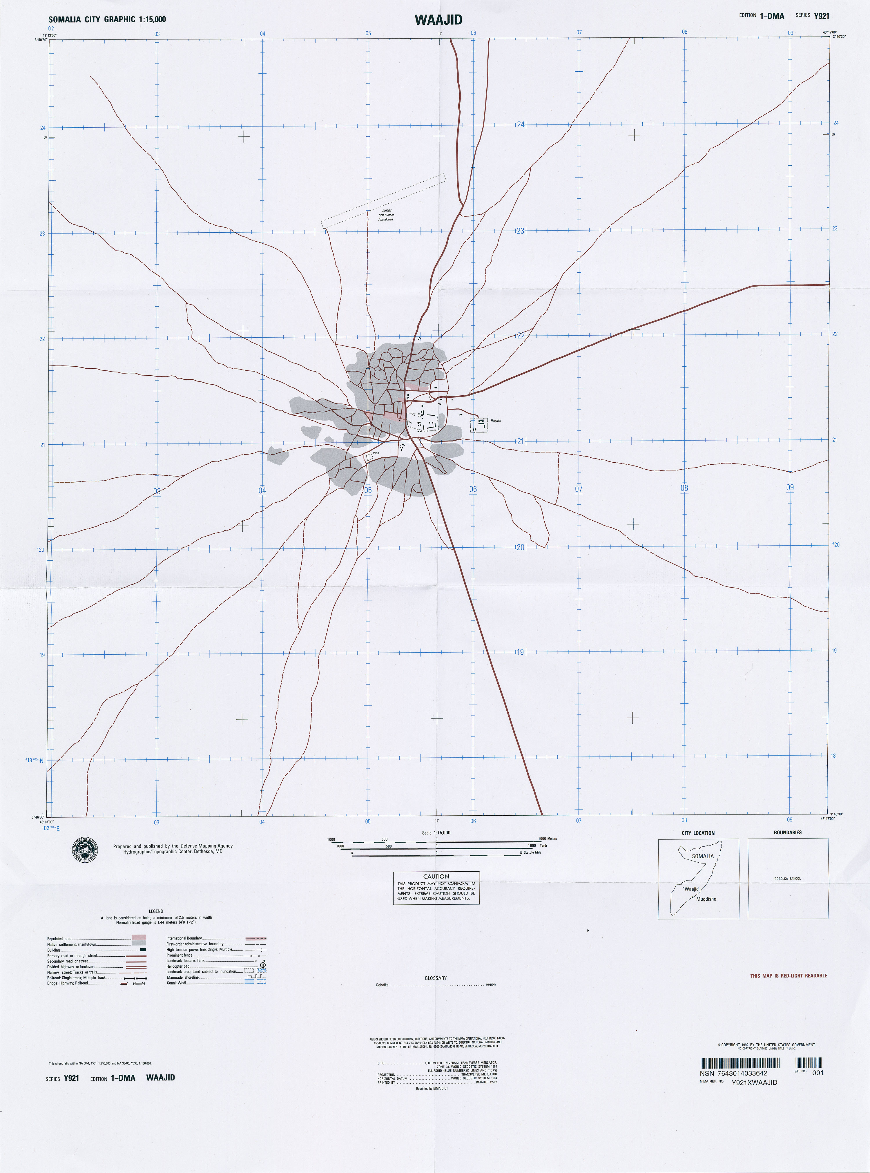
- Waajid Series Y921, Edition 1-DMA, Somalia City Graphic, Original scale 1:15,000, U.S. National Imagery and Mapping Agency, published 1992, reprinted 2001 (1.8MB)
- Xudder [Oddur] 1:15,000, Edition 1-DMA, Series Y921. U.S. Defense Mapping Agency, 1992 (6.9MB)
![Boosaaso [Bender Cassim]](world_cities/txu-oclc-49606971-boosaaso-1992.jpg)
![Caluula [Alula]](world_cities/txu-oclc-78055671-caluula-1983.jpg)
![Dhuusamarreeb [Dusa Marreb]](world_cities/txu-oclc-56908345-dhuusamarreeb-1990.jpg)
![Gaalkacyo [Galcaio]](world_cities/txu-oclc-49606960-gaalkacyo-1992.jpg)
![Marka [Merka]](world_cities/txu-oclc-50216366-marka-1992.jpg)
![[Mogadishu] City Plan](africa/mogadishu_1992.jpg)
![[Mogadishu] Neighborhoods of Mogadishu](africa/txu-pclmaps-oclc-795784383-somalia_2012_neighborhoods_of_mogadishu.jpg)
![[Mogadishu] Mogadiscio Region](africa/mogadiscio_1968.jpg)
![[Mogadishu] Muqdisho, Sheet 1](world_cities/txu-oclc-53502081-muqdisho1-1993-small.jpg)
![[Mogadishu] Muqdisho, Sheet 1](world_cities/txu-oclc-53502081-muqdisho1-1993.jpg)
![[Mogadishu] Muqdisho, Sheet 2](world_cities/txu-oclc-53502081-muqdisho2-1993-small.jpg)
![[Mogadishu] Muqdisho, Sheet 2](world_cities/txu-oclc-53502081-muqdisho2-1993.jpg)
![Xudder [Oddur]](world_cities/txu-oclc-49864489-xudder-1992.jpg)
- 1:2,000,000 - Africa Topographic Maps U.S. Army Map Service, Series 2201
- This series covers all of Somalia
- 1:1,000,000 - Operational Navigation Chart Series U.S. Defense Mapping Agency Aerospace Center. Not for navigational use
- This series covers all of Somalia
- 1:1,000,000 - International Map of the World U.S. Army Map Service
- This series covers most of Somalia
- 1:500,000 - Tactical Pilotage Charts U.S. National Imagery and Mapping Agency. Not for navigational use
- This series covers Somalia
- 1:500,000 - East Africa Topographic Maps Series Y401 (GSGS 4335), U.S. Army Map Service, 1958-
- This series covers parts of Somalia
- 1:500,000 - World Series 1404, Great Britain. War Office and Air Ministry. 1958-
- This series covers parts of Somalia
- 1:250,000 - Joint Operations Graphic Series - Somalia [North] U.S. Defense Mapping Agency. Not for navigational use
- Only four sheets cover parts of Somalia [North]
- 1:250,000 - Joint Operations Graphic Series - Somalia [South] East Africa U.S. Defense Mapping Agency. Not for navigational use
- Only two sheets cover parts of Somalia [South]
- 1:100,000 - Somalia [North] Topographic Maps U.S. National Imagery and Mapping Agency, Series Y629 [PDF format]
- 1:100,000 - Somalia [South] Topographic Maps U.S. National Imagery and Mapping Agency, Series Y630 [PDF format]
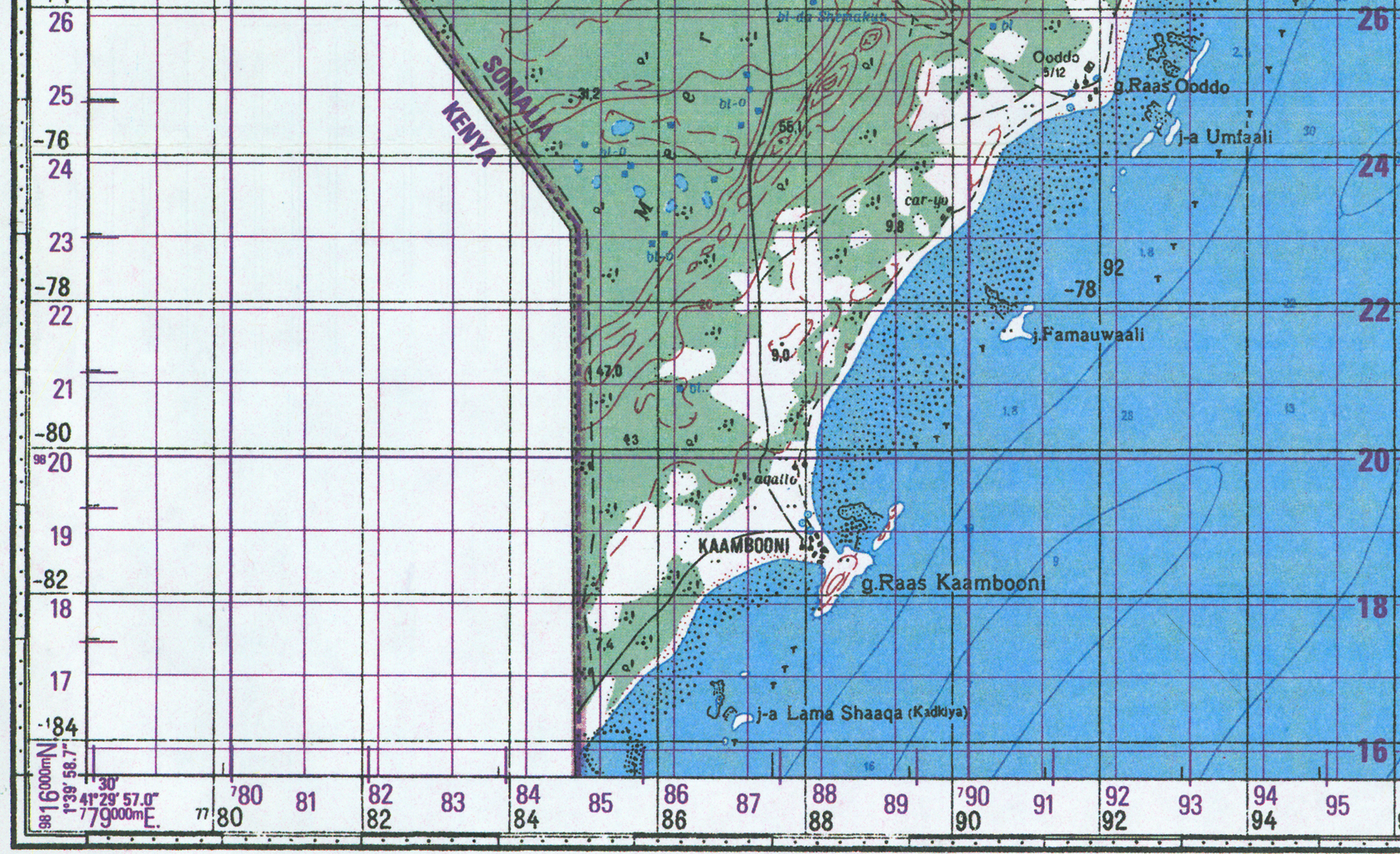
- 1:100,000 - Ras Kamboni Area, Southern Tip of Somalia Portion of Sheet SA-37-60, Series Y630, DMA, 1992 (2.5 MB)
- This series covers all of Somalia
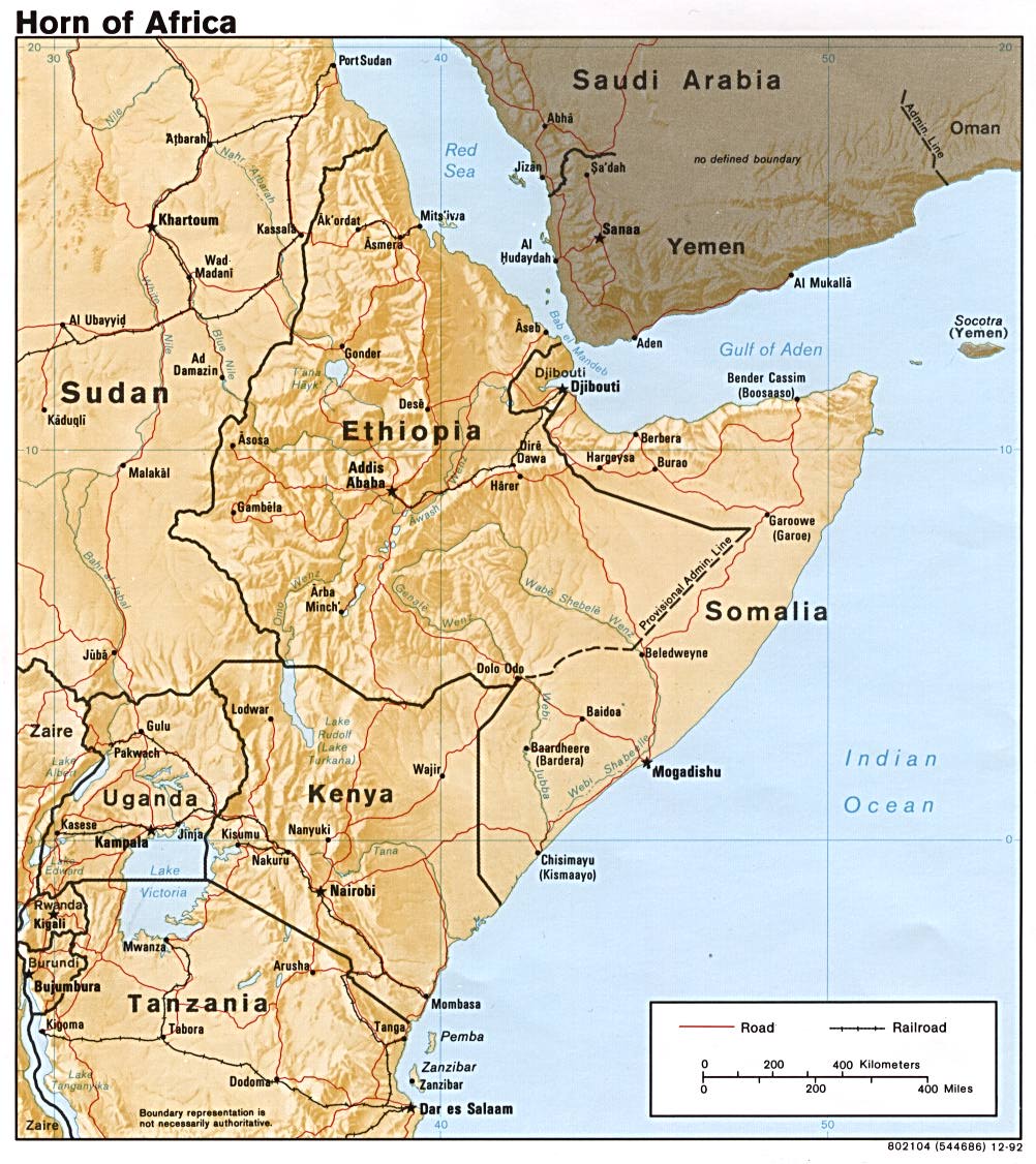
- Horn of Africa (Shaded Relief) 1992 (218K)
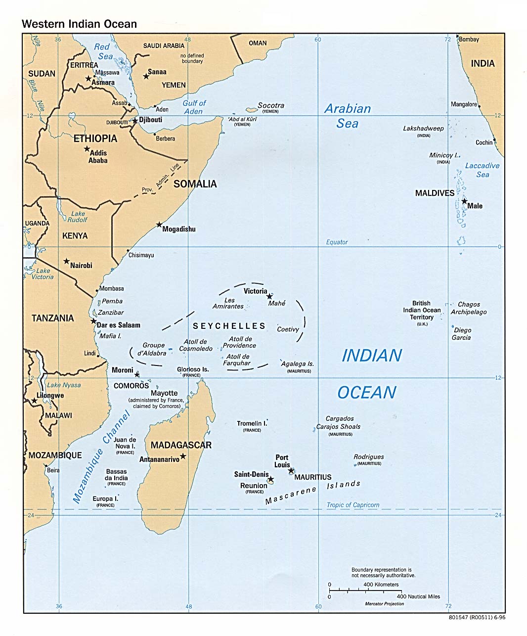
- Western Indian Ocean (Political) 1996 (193K)
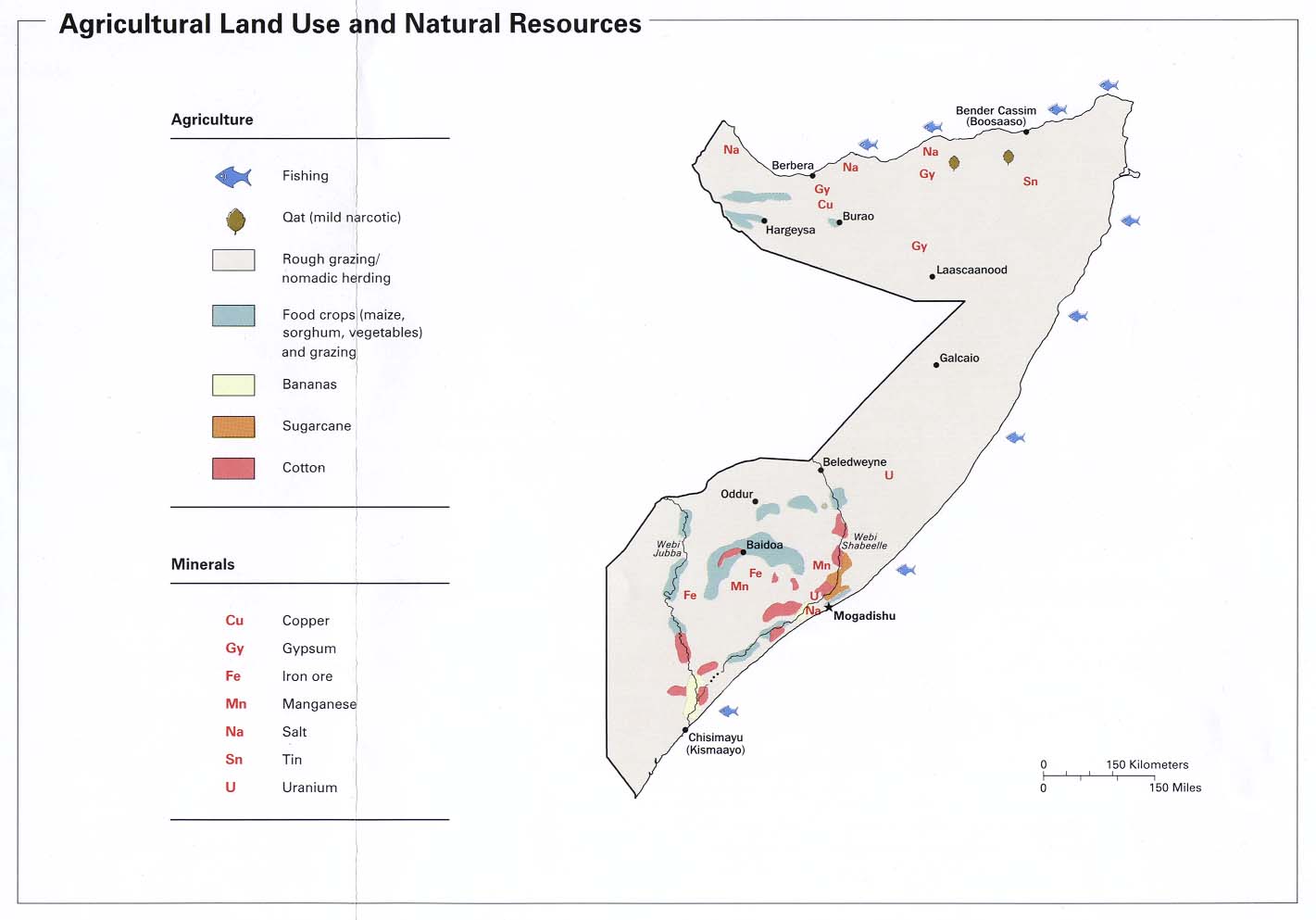
- Agricultural Land Use and Natural Resources from Somalia Summary Map, CIA 2002 (84K)
- Agricultural Land Use and Natural Resources from Somalia Summary Map, CIA 1992 (89K)
- Area Comparison from Somalia and Djibouti Map, CIA 1977 (67K)
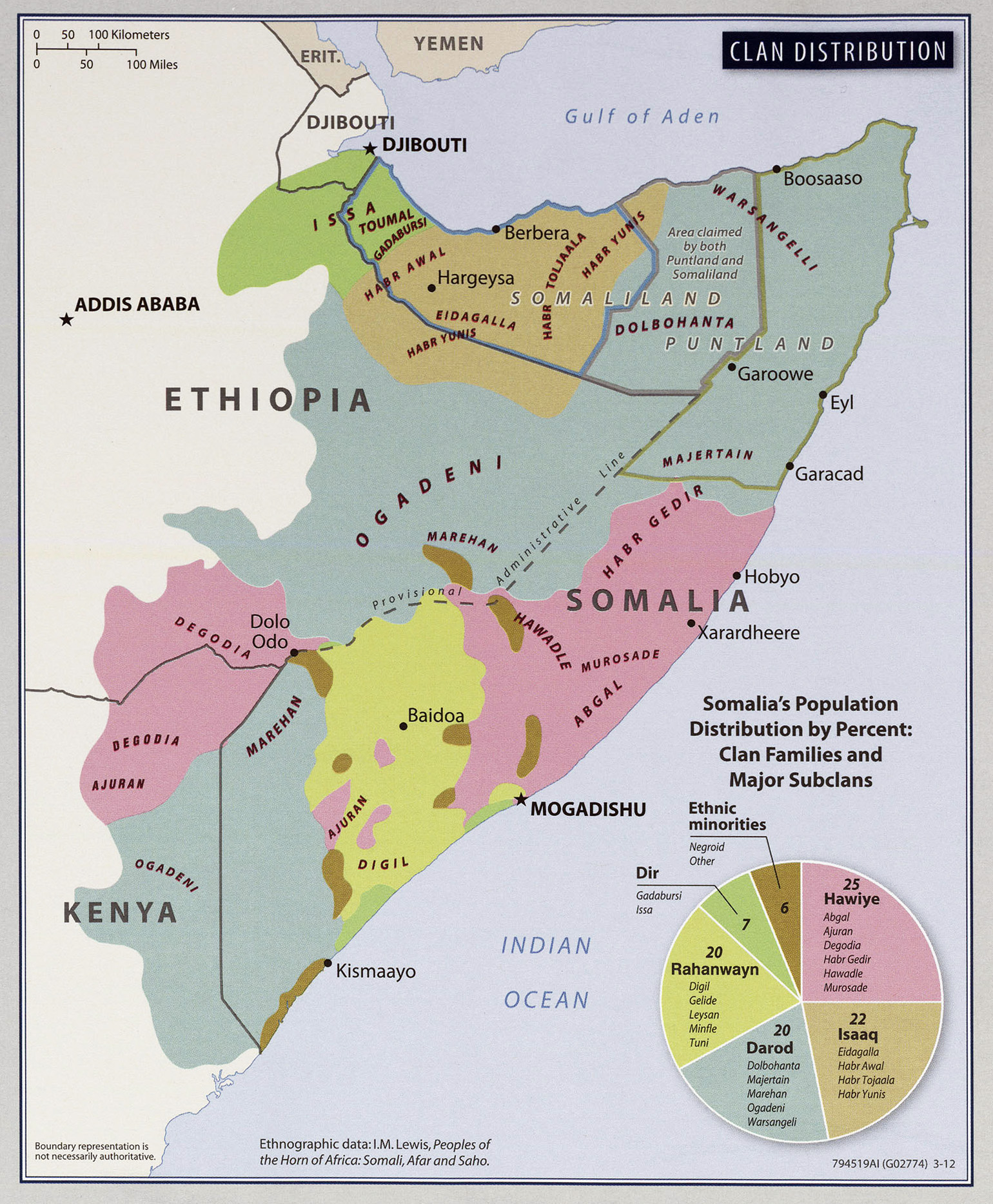
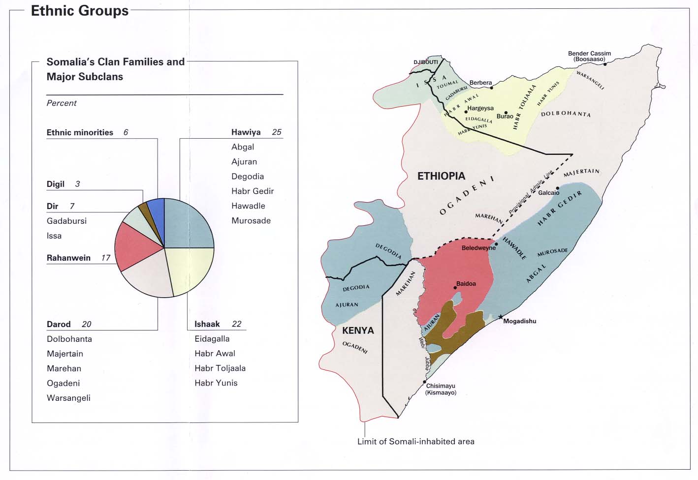
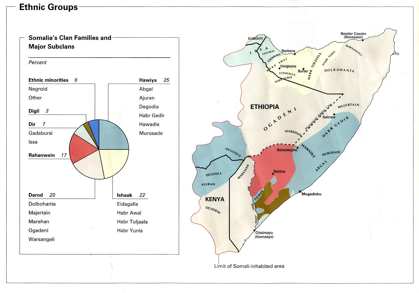
- Clan Distribution From Somalia Country Profile, 2012 (909K)
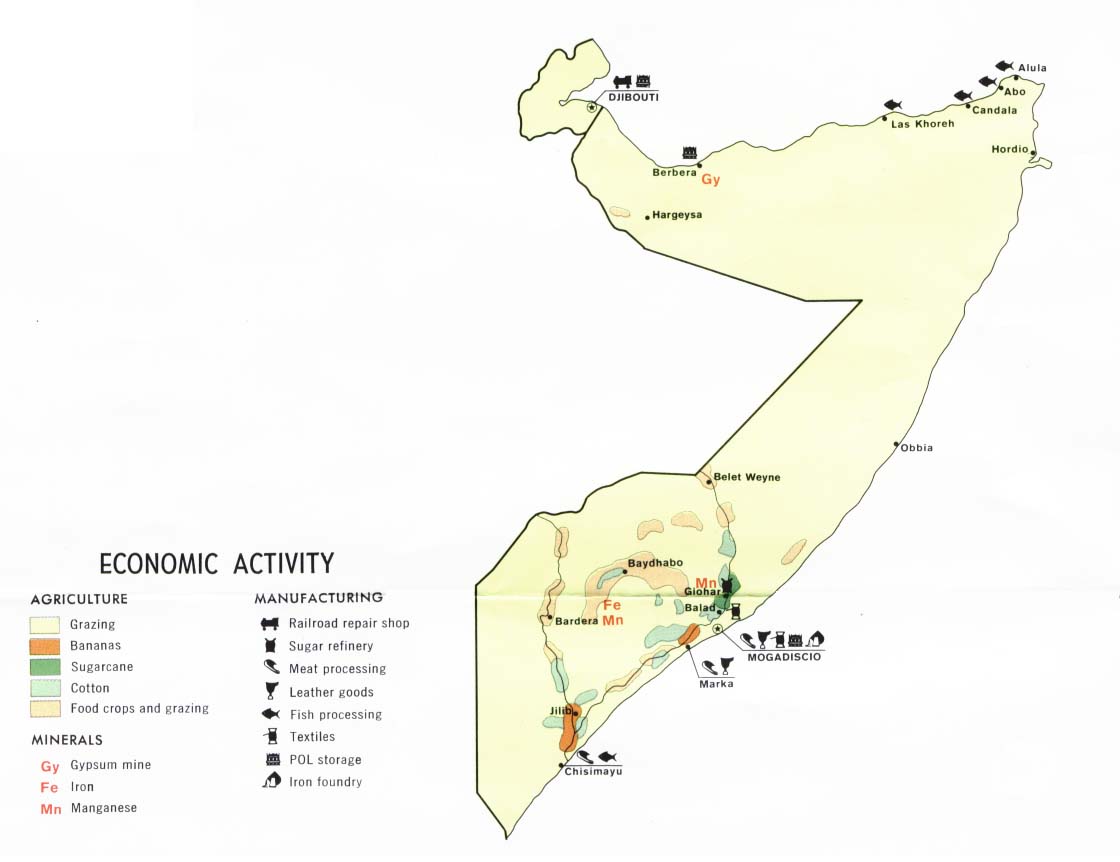
- Economic Activity from Somalia and Djibouti Map, CIA 1977 (61K)
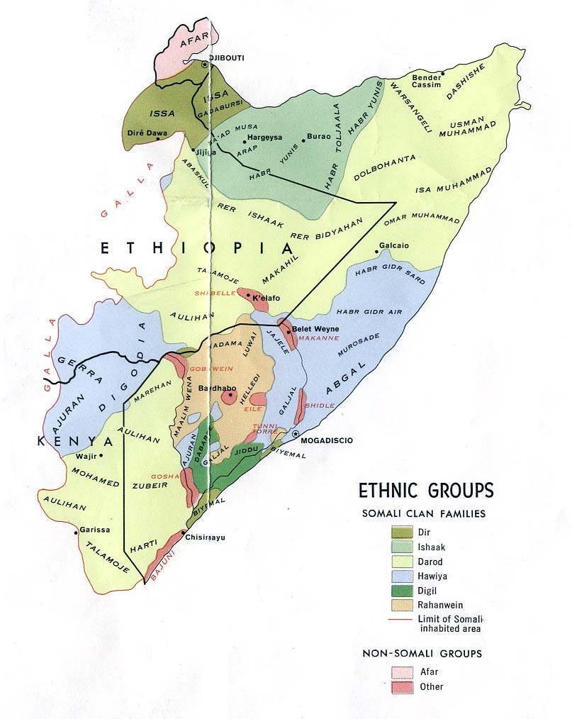
- Ethnic Groups from Somalia Summary Map, CIA 2002 (103K)
- Ethnic Groups from Somalia Summary Map, CIA 1992 (119K)
- Ethnic Groups from Somalia and Djibouti Map, CIA 1977 (105K)
- Ethnic Groups - Horn of Africa 1980 (213K)
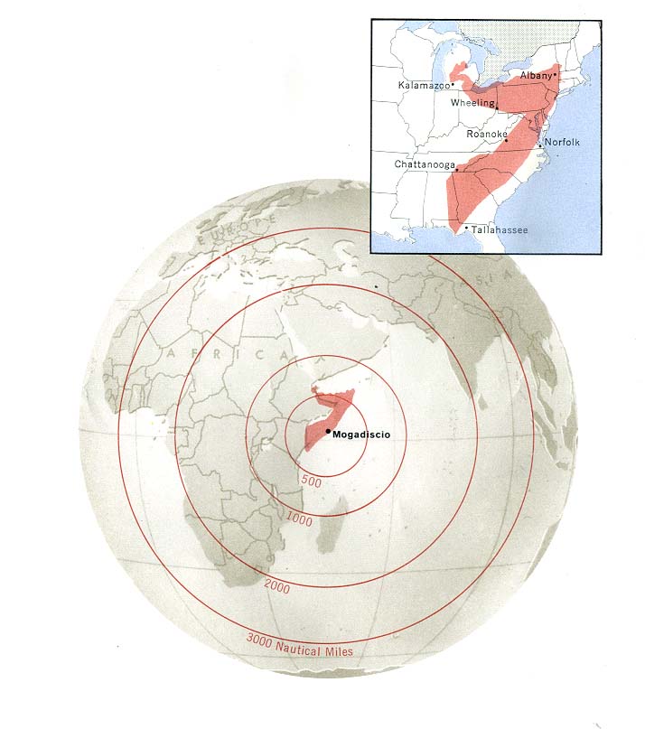
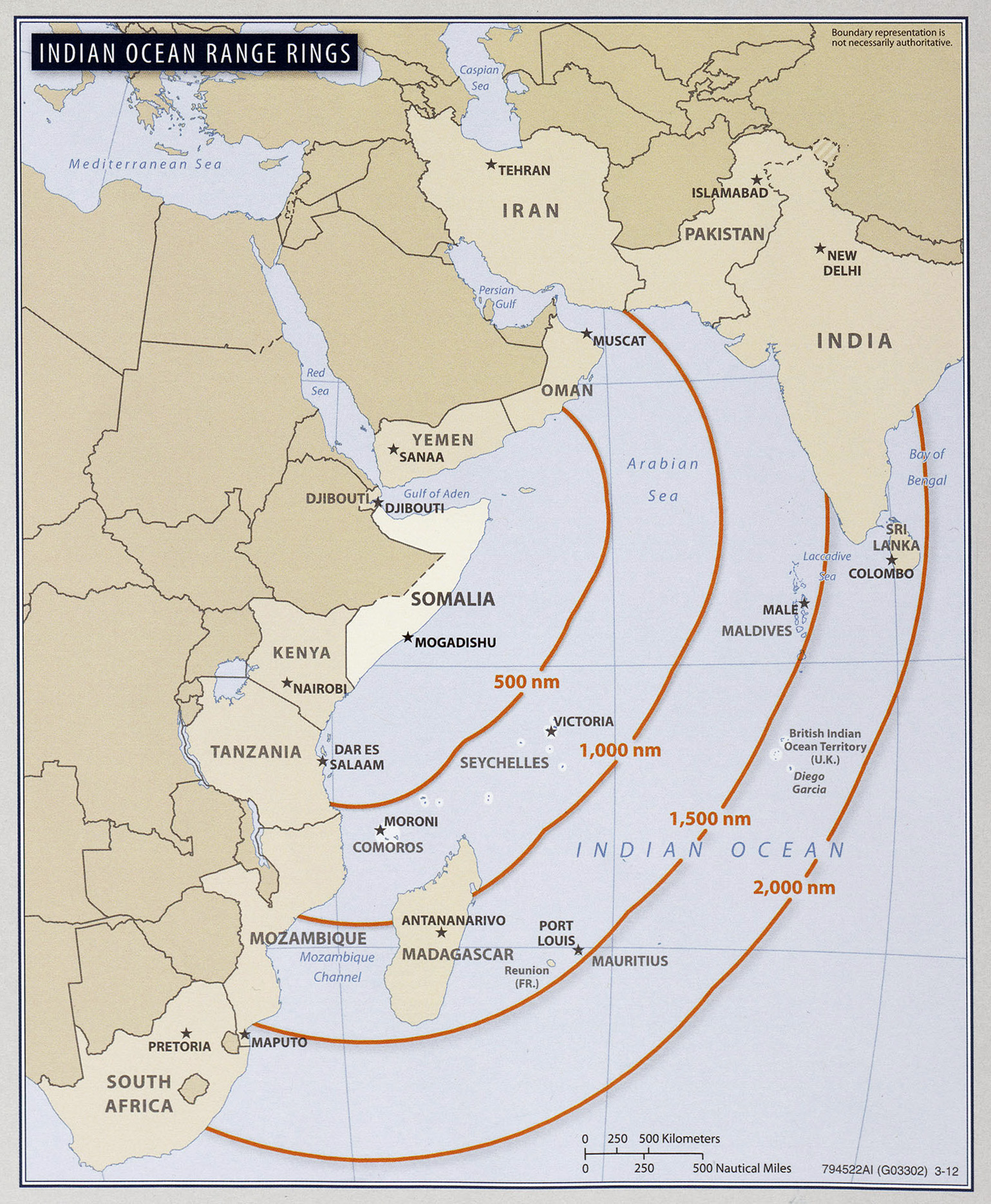
- Indian Ocean Range Rings From Somalia Country Profile, 2012 (959K)
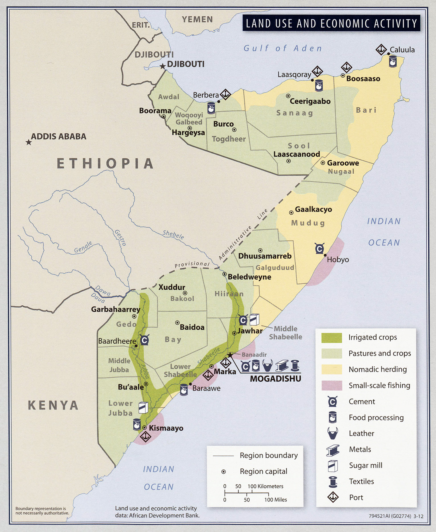
- Land Use and Economic Activity From Somalia Country Profile, 2012 (833K)
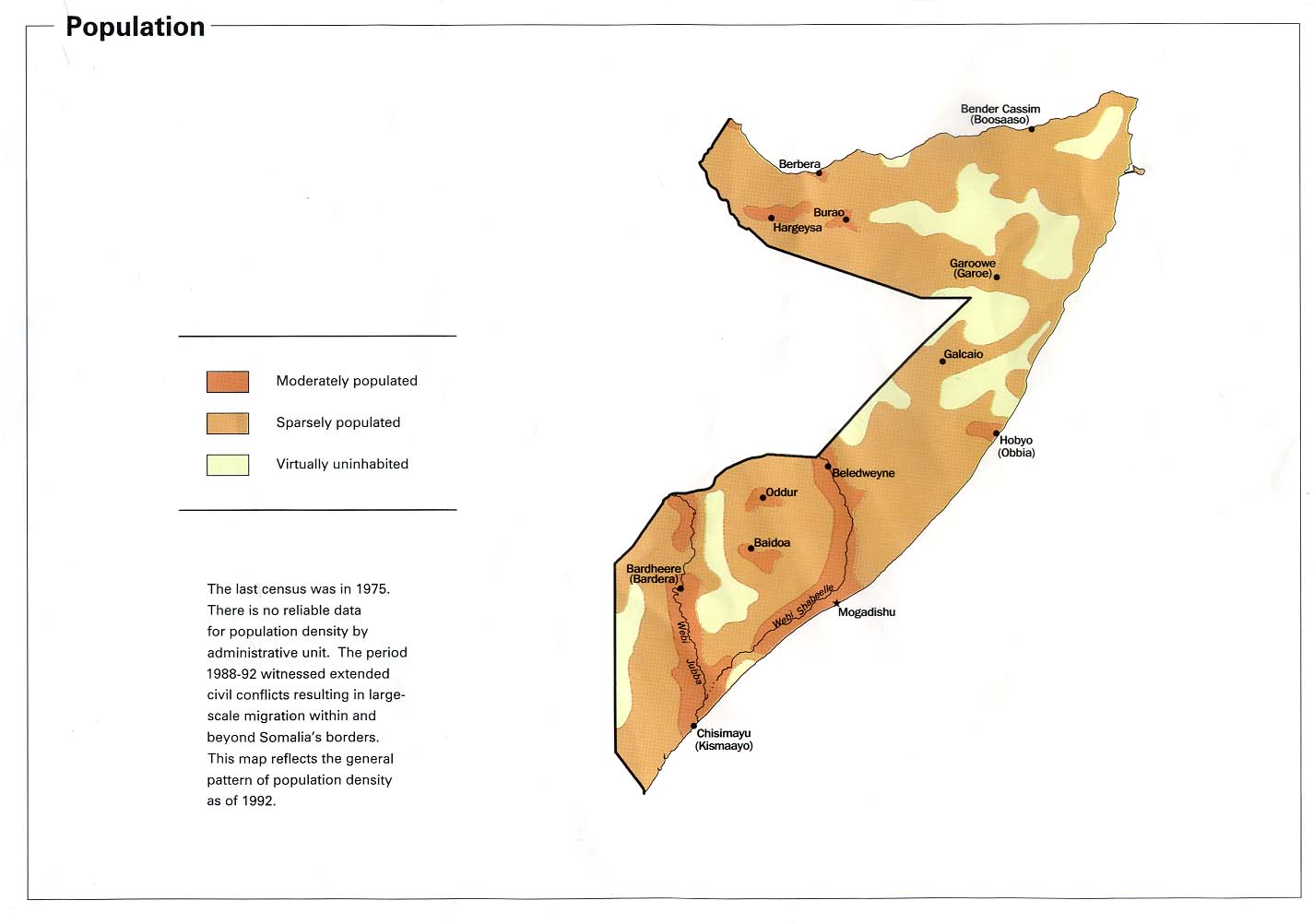
- Population from Somalia Summary Map, CIA 2002 (83K)
- Population from Somalia Summary Map, CIA 1992 (91K)
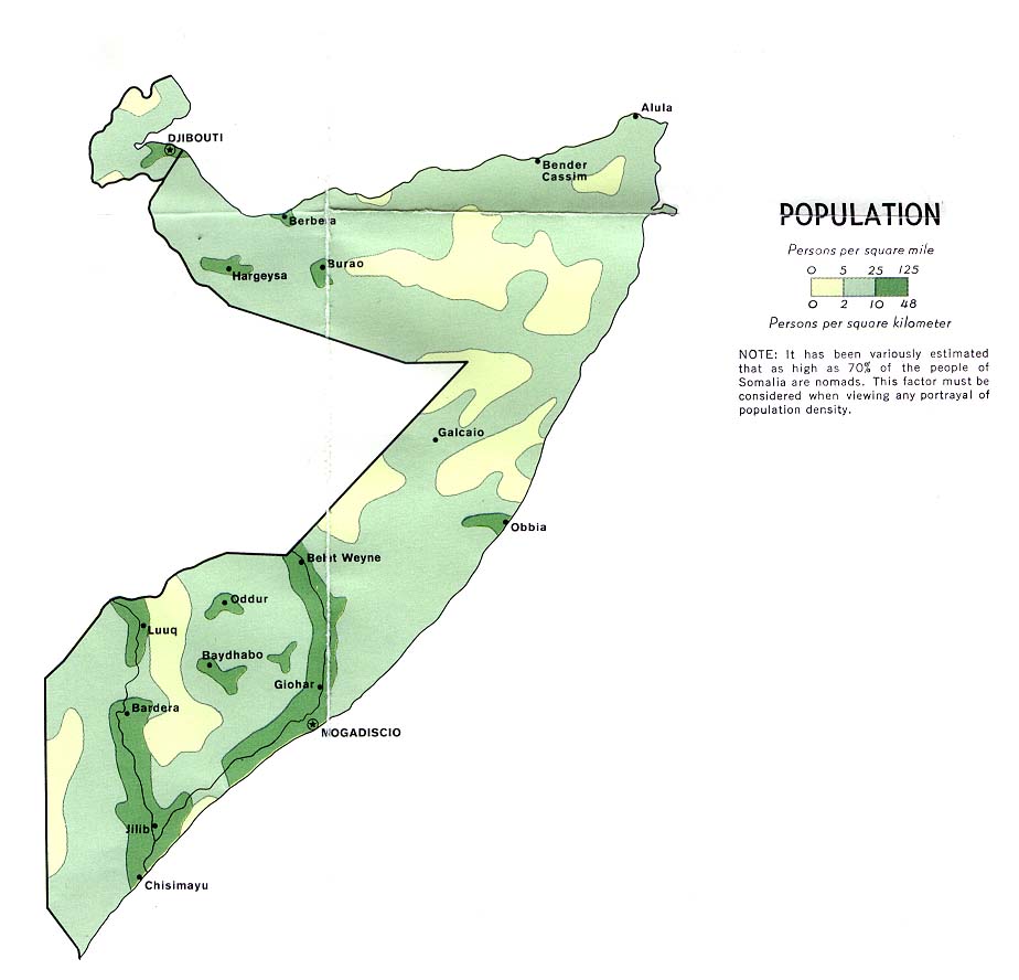
- Population from Somalia and Djibouti Map, CIA 1977 (75K)
- Population Density From Somalia Country Profile, 2012 (953K)
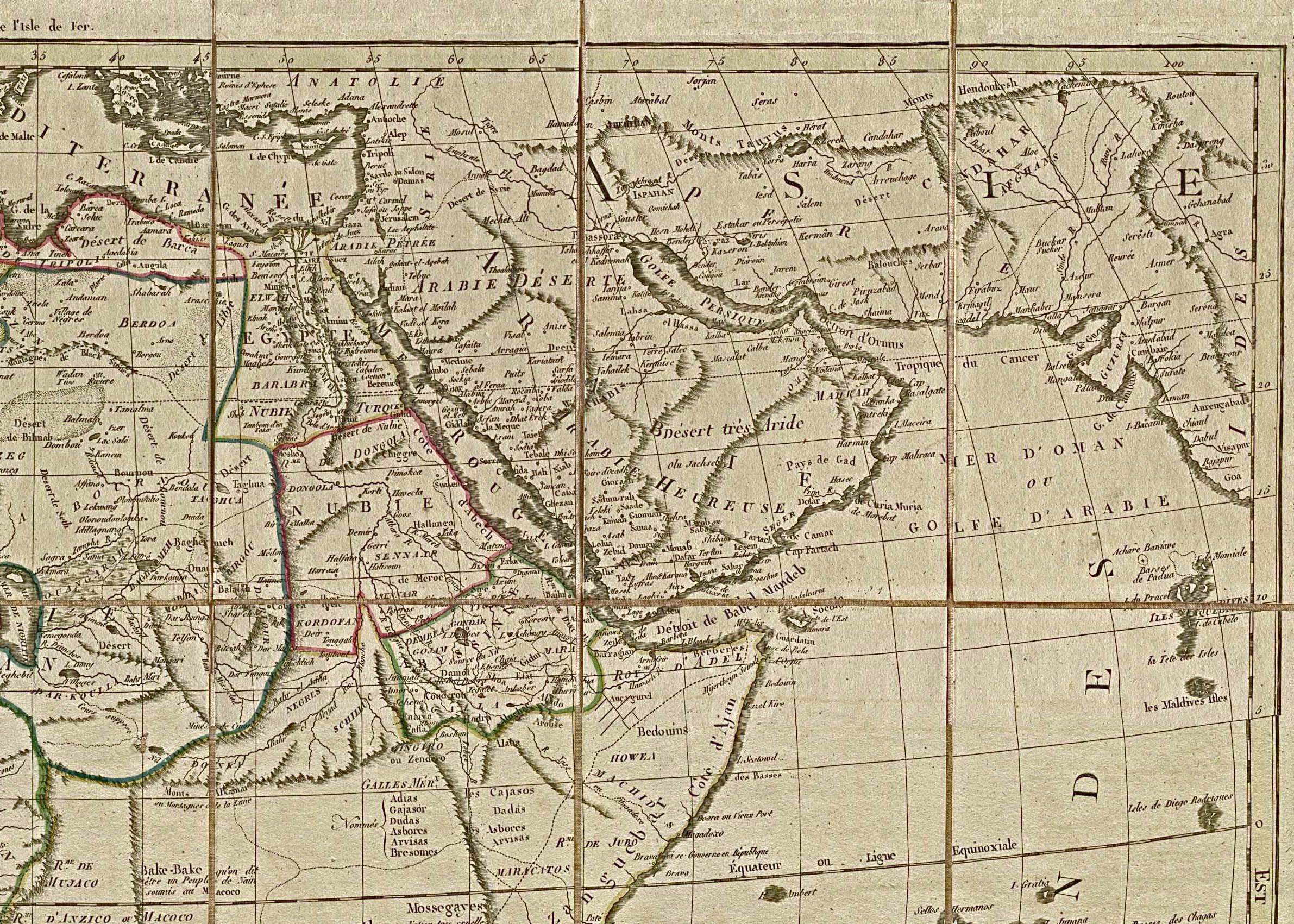
- Northeast Africa and the Near East 1829 (942K)
- A portion of "Carte Generale De L'Afrique" by Eustache Herisson, 1829.
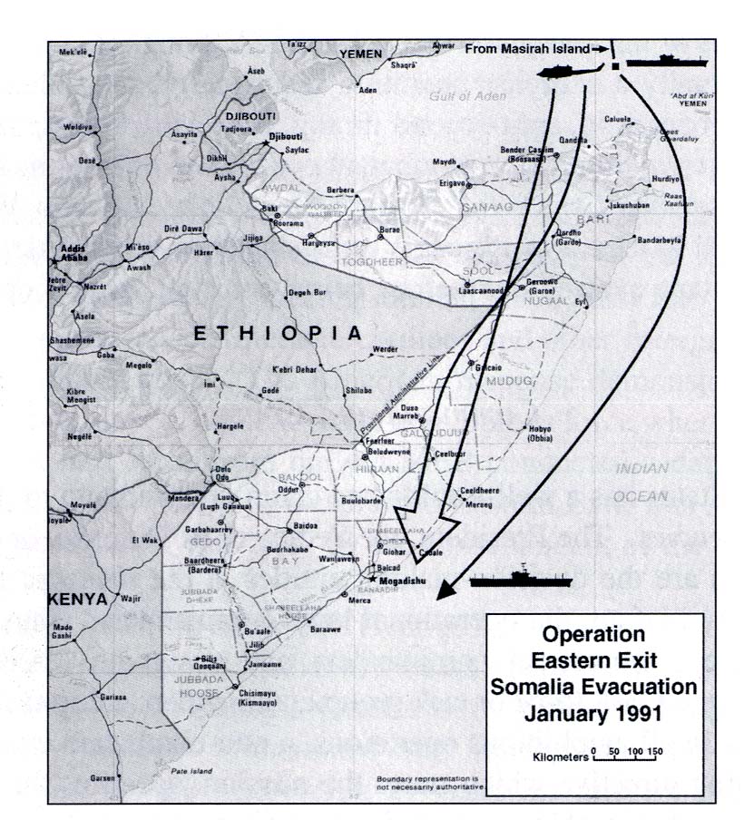
- Operation Eastern Exit, Somalia Evacuation January 1991 (174K)
- From U.S. Marines in the Persian Gulf, 1990-1991: With Marine Forces Afloat in Desert Shield and Desert Storm by Ronald J. Brown. U.S. Marine Corps, History and Museums Division, Washington, D.C. 1998.
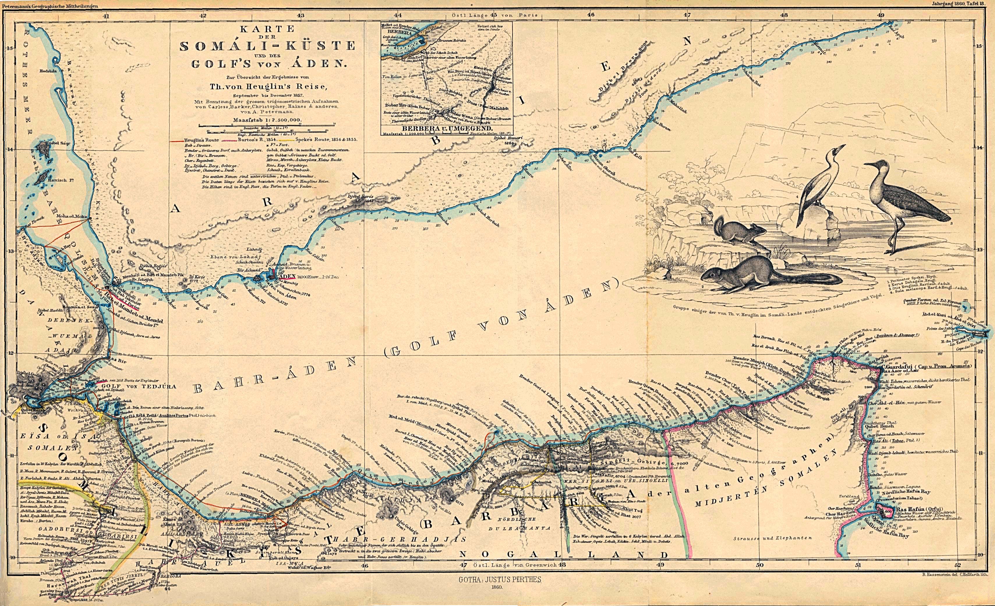
- Somali Coast and Aden Gulf 1860 (1MB)
- "Karte der Somali-Kuste und des Golf's von Aden" From Mittheilungen aus Justus Perthes' Geographischer Anstalt uber Wichtige Neue Erforschungen auf dem Gesammtgebiete der Geographie von Dr. A. Petermann. Volume 6, 1860.
- A portion of "Carte Generale De L'Afrique" by Eustache Herisson, 1829.
Maps on Other Web Sites
- Somalia (United Nations) [PDF]
- Somalia - Ethnic Groups (Magellan)
- Somalia - Live Piracy Map (ICC)
- Somalia - Maps (ReliefWeb)
- Somalia - Maps (UNOSAT)
- Somalia - Northern (Peter Loud)
- Somalia - Southern (Peter Loud)
- Somalia and Ethiopia - Refugee Camp Maps (ZKI)
- [2016 January 4] Somalia - Situation (Thomas van Linge/IUCA)
- [2015 September 16] Somalia - Situation (Thomas van Linge)
- [September 2015] Somalia - Control (BBC News)
- [2015 March] Somalia - Humanitarian Snapshot (OCHA)
- [2014 October 14] - Somalia - Political Situation (Wikimedia)
- [2014 October 6] Somalia - Situation (Thomas van Linge)
- [2013] Who Runs Somalia? (BBC News)
- [2012] Somaliland [Northern Somalia] (BBC News)
- [2011 July] Somalia - Current Political Situation (Wikipedia)
- [2010 April] Somalia - Political Situation Map (Wikipedia)
- [2009] Live Piracy Map (International Maritime Bureau)
- [2009] Piracy Attacks off Somalia [April 2009] (BBC News)
- [2009] Somalia - Political Situation Map (Wikipedia)
- [2009] Puntland [Northern Somalia] (Puntland State of Somalia/Internet Archive)
- [2008] Somalia - Piracy Map (BBC News)
- [2007] Somaliland Border Dispute (Wikipedia)
- [2007] Ras Kamboni Area, Satellite Image [Site of battle, January 2007] (Google Maps)
- [2007] Somalia - U.S. Navy Patrols and Air Strikes [January 2007] (BBC News)
- [2006] Somalia - Ethiopian Troop Movements Map [December 30, 2006] (The Fourth Rail/Magellan)
- [2006] Somalia - Offshore Pirate Attacks (UNOSAT)
- [2002] Puntland [Northern Somalia] (BBC News)
![[2015 September 16] Somalia - Situation (Thomas van Linge)](https://pietervanostaeyen.files.wordpress.com/2015/09/2000px-somalia.png)
![[September 2015] Somalia - Control (BBC News)](http://ichef.bbci.co.uk/news/624/cpsprodpb/8694/production/_87725443_somalia_control_624_v10.png)
![[2014 October 14] - Somalia - Political Situation (Wikimedia)](http://upload.wikimedia.org/wikipedia/commons/9/9f/Somalia_map_states_regions_districts.png)
![[2014 October 6] Somalia - Situation (Thomas van Linge)](http://i.imgur.com/xXmlr11.png)
![[2011 July] Somalia - Current Political Situation (Wikipedia)](http://en.wikipedia.org/wiki/File:Fedmap4.png)
![[2010 April] Somalia - Political Situation Map (Wikipedia)](http://en.wikipedia.org/wiki/Image:Somalia_map_states_regions_districts.png)
![[2009] Piracy Attacks off Somalia [April 2009] (BBC News)](http://newsimg.bbc.co.uk/media/images/45647000/gif/_45647302_africa_piracy_maersk_226.gif)
![[2008] Somalia - Piracy Map (BBC News)](http://newsimg.bbc.co.uk/media/images/45217000/gif/_45217511_africa_piracy_map226_3.gif)
![[2007] Somaliland Border Dispute (Wikipedia)](http://en.wikipedia.org/wiki/File:Map_of_somaliland_border_claims.jpg)
![[2007] Somalia - U.S. Navy Patrols and Air Strikes [January 2007] (BBC News)](http://newsimg.bbc.co.uk/media/images/42429000/gif/_42429309_somalia_hayo_map416.gif)
![[2006] Somalia - Ethiopian Troop Movements Map [December 30, 2006] (The Fourth Rail/Magellan)](http://billroggio.com/maps/Somalia-battle-12302006.jpg)
![[2006] Somalia - Offshore Pirate Attacks (UNOSAT)](http://web.archive.org/web/20090310220054/http://unosat.web.cern.ch/unosat/freeproducts/east_and_horn_of_africa/UNOSAT_horn_piracy28mar06_small.jpg)
- Baydhabo (LeadDog)
- Beledweyne (LeadDog)
- Berbera (LeadDog)
- Boosaaso (LeadDog)
- Buulo Berde (LeadDog)
- Buurhakaba (LeadDog)
- Burco (LeadDog)
- Gaalkacyo (LeadDog)
- Harardhere (Google Maps)
- Hargeysa (LeadDog)
- Jamaame (LeadDog)
- Jilib (LeadDog)
- Jowhar (LeadDog)
- Kismaayo (LeadDog)
- Marka (LeadDog)
- Mogadishu (Google Maps)
- Mogadishu (LeadDog)
- Mogadishu (UNHCR)
- Mogadishu [2007] (UNOSAT/Internet Archive)
- Mogadishu [1997] (Maps.com)
![Mogadishu [1997] (Maps.com)](http://media.maps.com/magellan/Images/MOGADI-W1.gif)