Perry-Castañeda Library
Map Collection
Historical Maps of Texas
Also See: Texas Historical City Maps
Early Texas:
- Prehistoric Texas (Texas Beyond History)
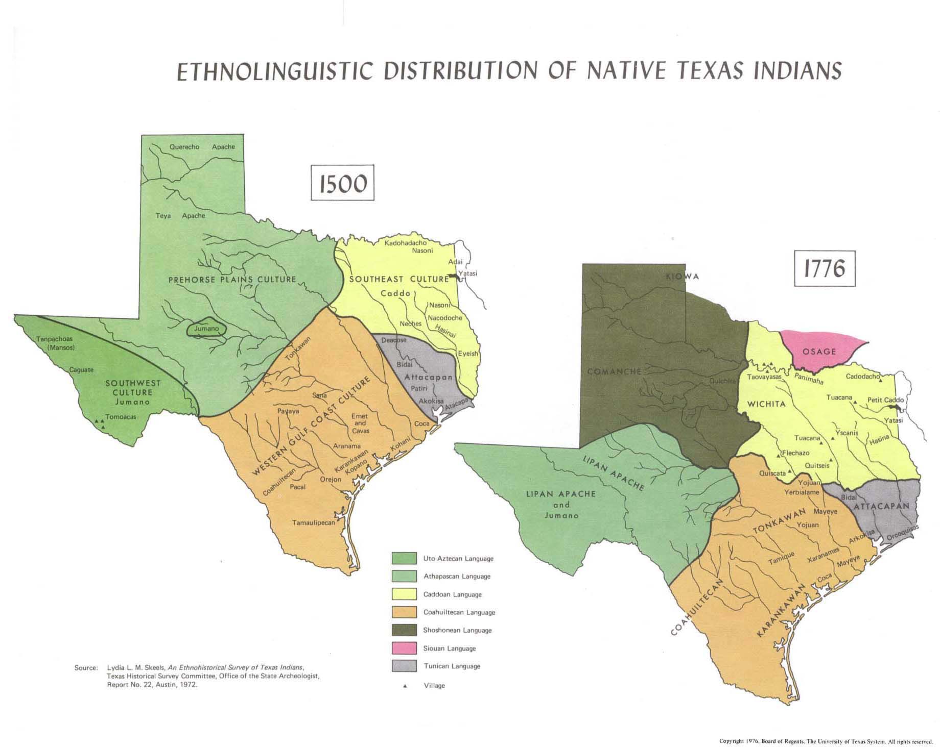
- Ethnolinguistic Distribution of Native Texas Indians (155K)
- From Atlas of Texas. Published by The University of Texas at Austin, Bureau of Business Research, 1976.
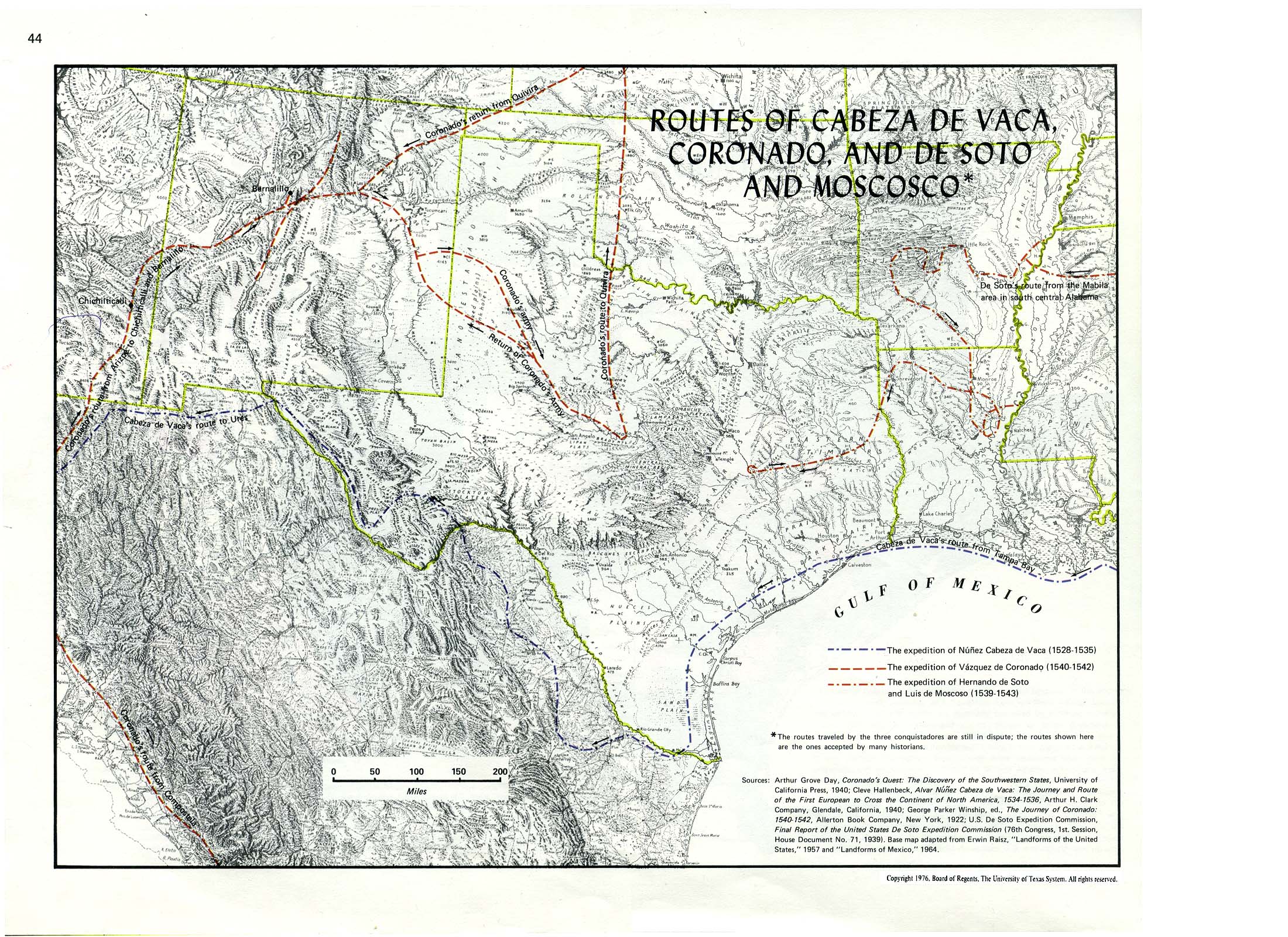
- Routes of Cabeza De Vaca, Coronado, and De Soto and Moscosco (860K)
- From Atlas of Texas. Published by The University of Texas at Austin, Bureau of Business Research, 1976.
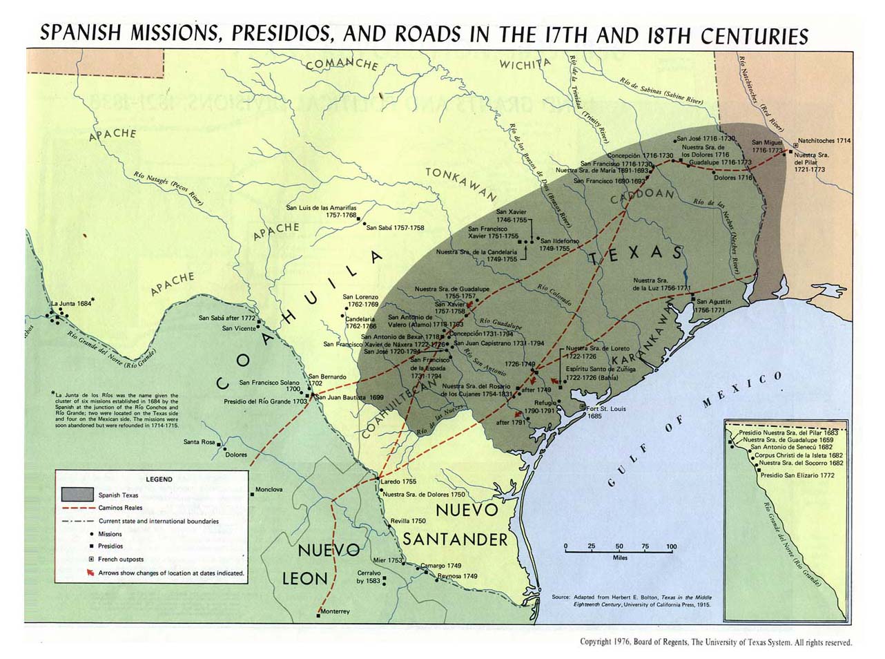
- Spanish Missions, Presidios, and Roads in the 17th and 18th Centuries (155K)
- From Atlas of Texas. Published by The University of Texas at Austin, Bureau of Business Research, 1976.
- Caddoan Languages and Peoples - 17th and 18th Centuries (Texas Beyond History)
- Texas Plains Indians - Early 1800s (Texas Beyond History)
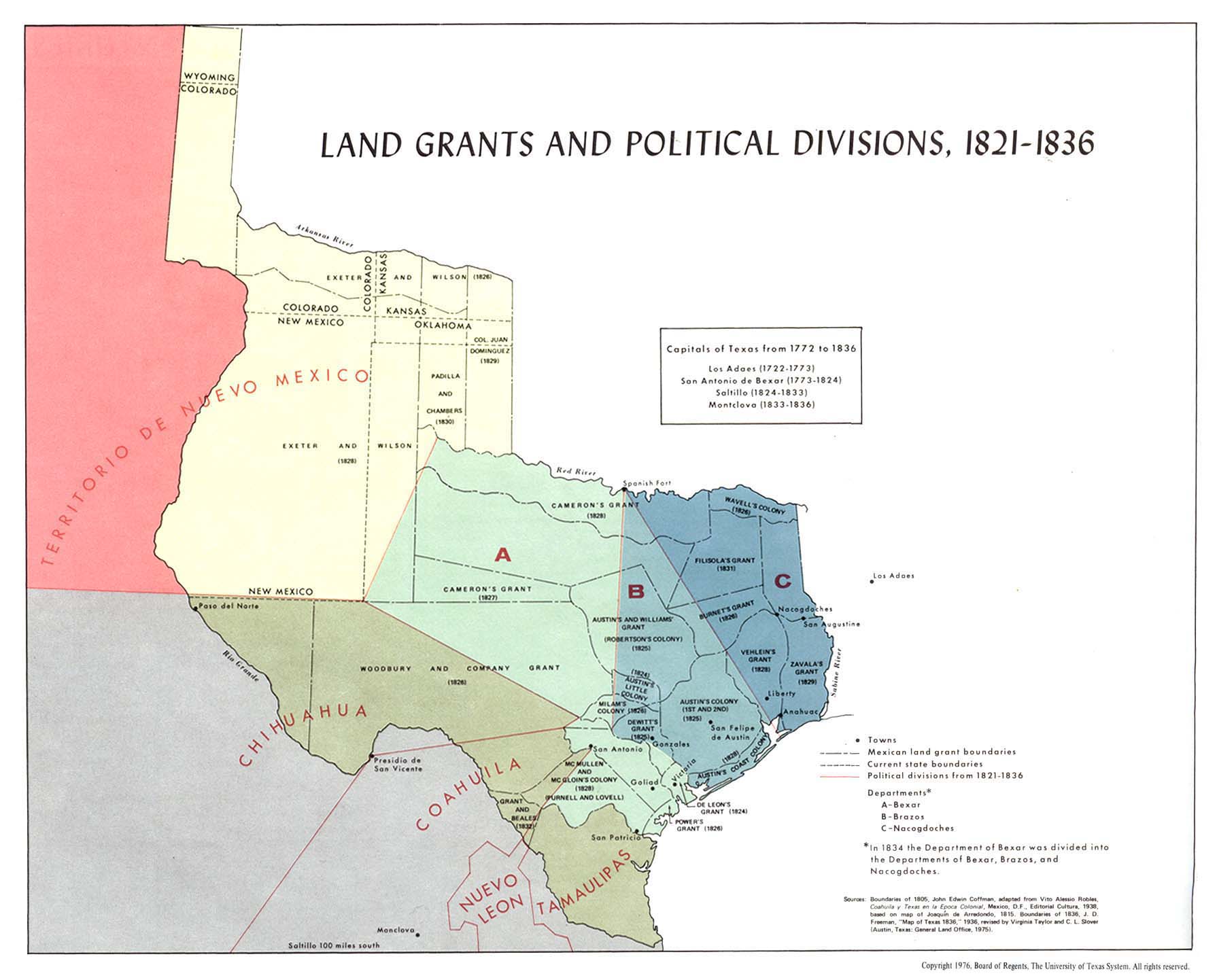
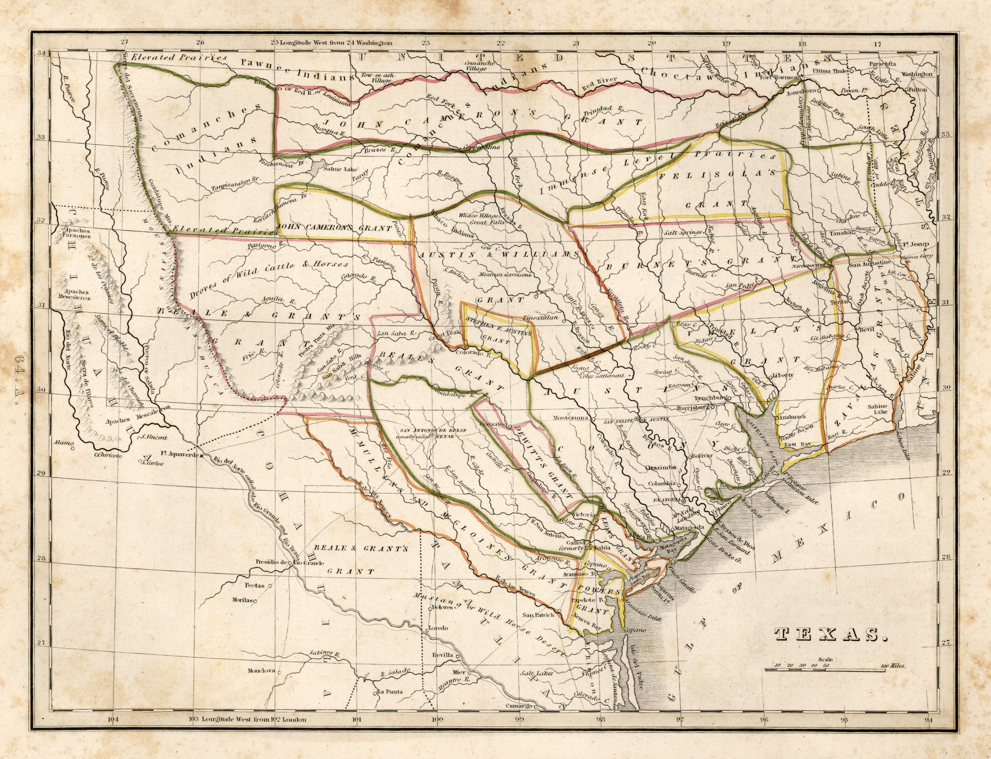
- Land Grants and Political Divisions, 1821-1836 (180K)
- From Atlas of Texas. Published by The University of Texas at Austin, Bureau of Business Research, 1976.
Texas Revolution, 1835-1836:
- Champ d'Asile [French Settlement] 1819 (972K)
- From Le Texas, ou Notice Historique sur le Champ d'Asile... by Louis Hartmann and Jean-Baptiste Millard. Paris: Béguin, Béchet, Delaunay, et a Gand, Houdin, Juin 1819. See the Champ d'Asile article in The Handbook of Texas Online for more information. Map courtesy Dorothy Sloan-Rare Books, Austin Texas
- Texas 1835 (1.7MB)
- From Comprehensive Atlas, Geographical, Historical and Commercial by Thomas Gamaliel Bradford, 1835. First issue of the first separate map of Texas to appear in an atlas. Courtesy Dorothy Sloan-Rare Books, Austin, Texas
- Texas Revolution Maps - 1835-1836 (Antonio Rafael de la Cova)
- Texas - 1836 (University of Oregon)
- Samuel Augustus Mitchell "A New Map of Texas..." - 1836 (David Rumsey Collection)
- San Jacinto Battlefield Map by Henry McArdle - 1836 (Texas State Library and Archives)
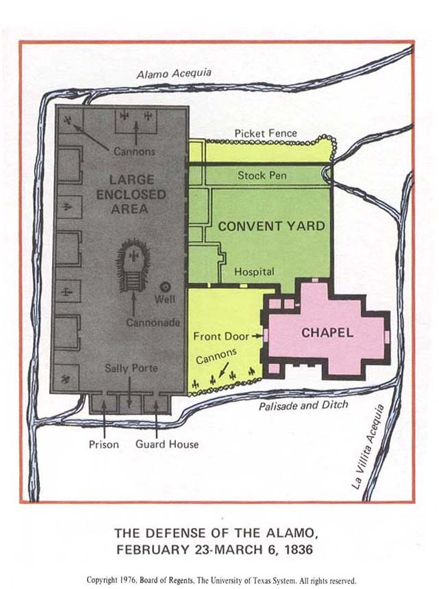
- The Defense of the Alamo, February 23 - March 6, 1836 (75K)
- From Atlas of Texas. Published by The University of Texas at Austin, Bureau of Business Research, 1976.
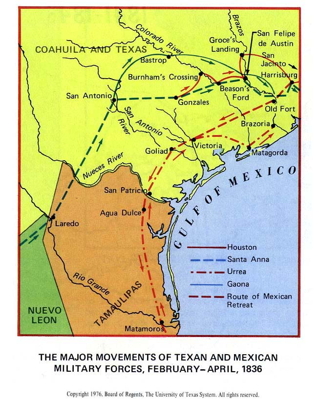
- The Major Movements of Texan and Mexican Military Forces, February - April, 1836 (119K)
- From Atlas of Texas. Published by The University of Texas at Austin, Bureau of Business Research, 1976.
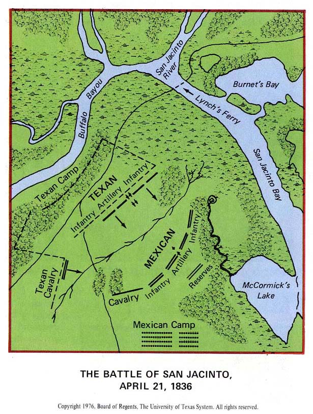
- The Battle of San Jacinto, April 21, 1836 (145K)
- From Atlas of Texas. Published by The University of Texas at Austin, Bureau of Business Research, 1976.
Republic of Texas 1836-1845:
- Texas During the Republic (Lone Star Junction)
- Home of the Cherokees in Texas - 1836 (Oklahoma State University)
- Thomas G. Bradford from "An Illustrated Atlas..." - 1838 (David Rumsey Collection)
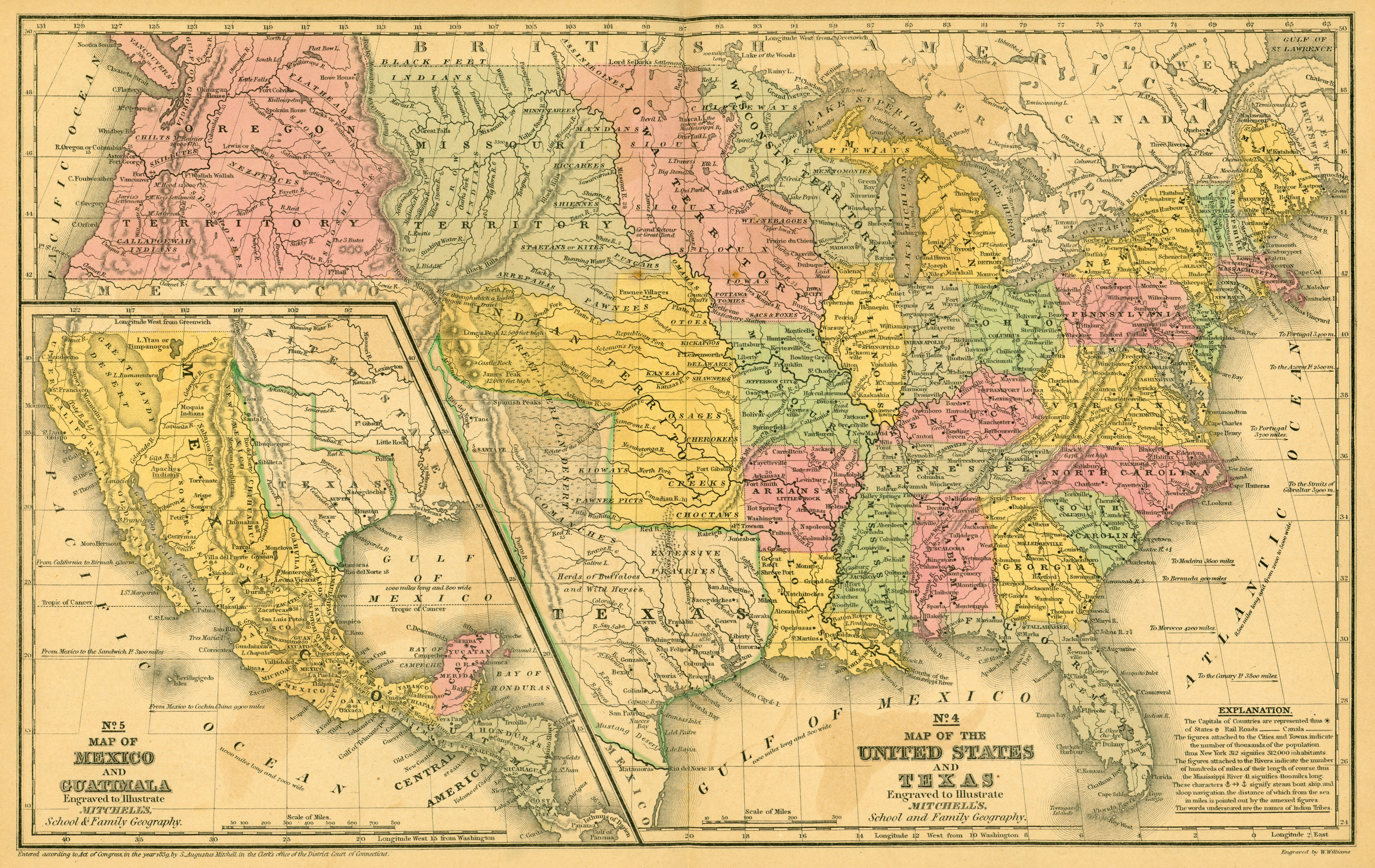
- United States and Texas 1839 (3.2 MB)
- Map of the United States and Texas Engraved to Illustrate Mitchell's School and Family Geography [with] Map of Mexico and Guatimala Engraved to Illustrate Mitchell's School and Family Geography. From Mitchell's School Atlas. Philadelphia: Thomas, Cowperthwait & Company, [1844], by S. Augustus Mitchell. Map courtesy Dorothy Sloan-Rare Books, Austin, Texas
-
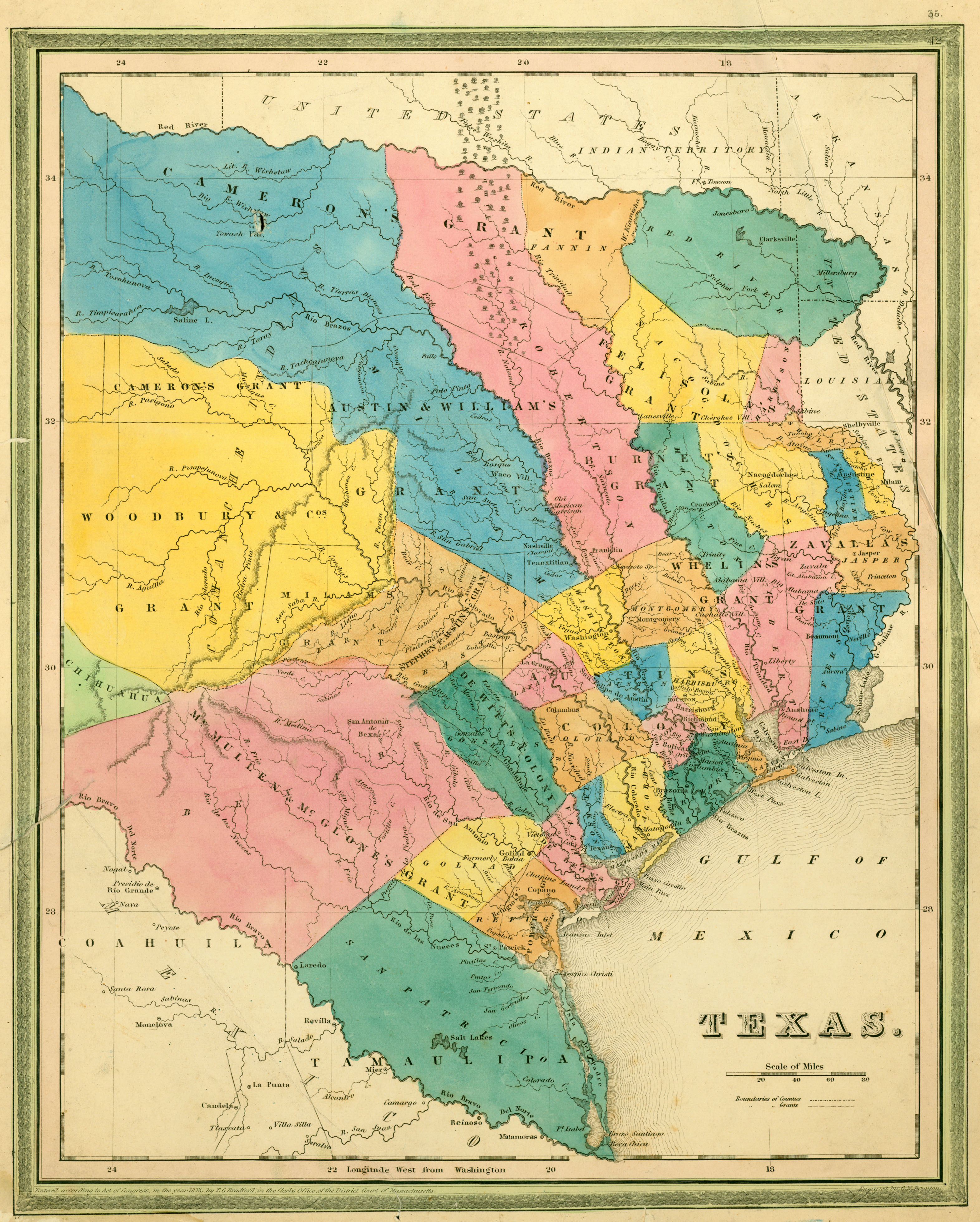
- Texas 1839 (2.6MB)
- Texas. T[homas] G[amaliel] Bradford. Entered According to Act of Congress, in the Year 1838, by T. G. Bradford, in the Clerks Office, of the District Court of Massachusetts, [top right above neat line] 42. Engraved by G. W. Boynton. [Boston, ca. 1839]. Advanced issue showing Austin as the capital (established 1839). Map courtesy Dorothy Sloan-Rare Books, Austin, Texas
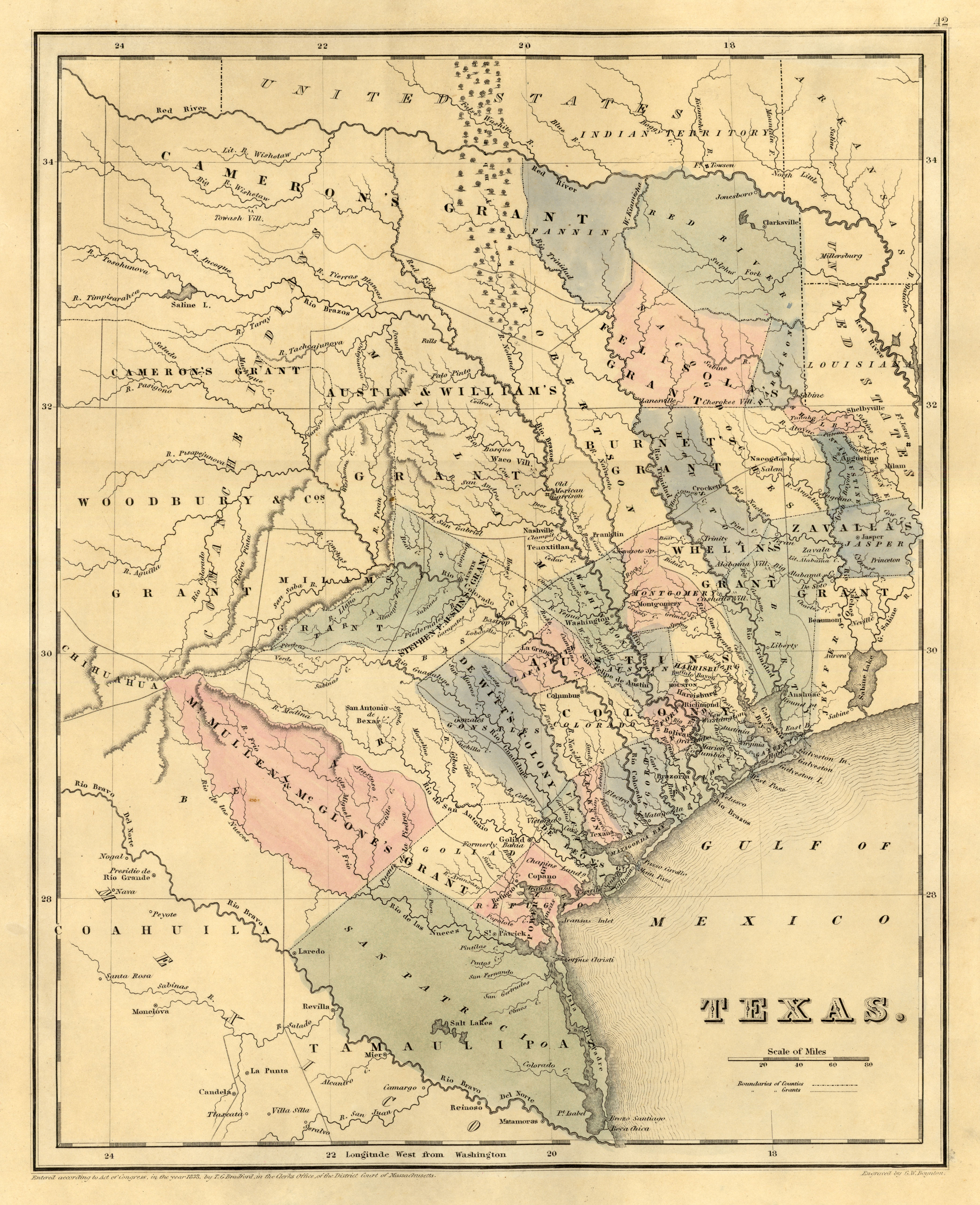
- Texas 1839 (3MB)
- Texas. T[homas] G[amaliel] Bradford. Entered According to Act of Congress, in the Year 1838, by T. G. Bradford, in the Clerks Office, of the District Court of Massachusetts, [top right above neat line] 35. Engraved by G. W. Boynton. [Boston, ca. 1839]. Advanced issue showing Austin as the capital (established 1839). Map courtesy Dorothy Sloan-Rare Books, Austin, Texas
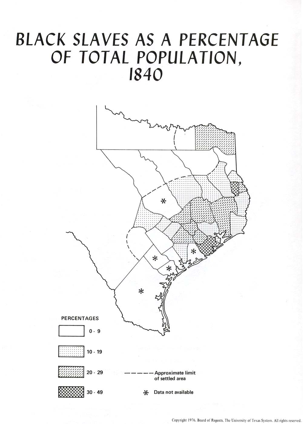
- Black Slaves as a Percentage of Total Population, 1840 (104K)
- From Atlas of Texas. Published by The University of Texas at Austin, Bureau of Business Research, 1976.
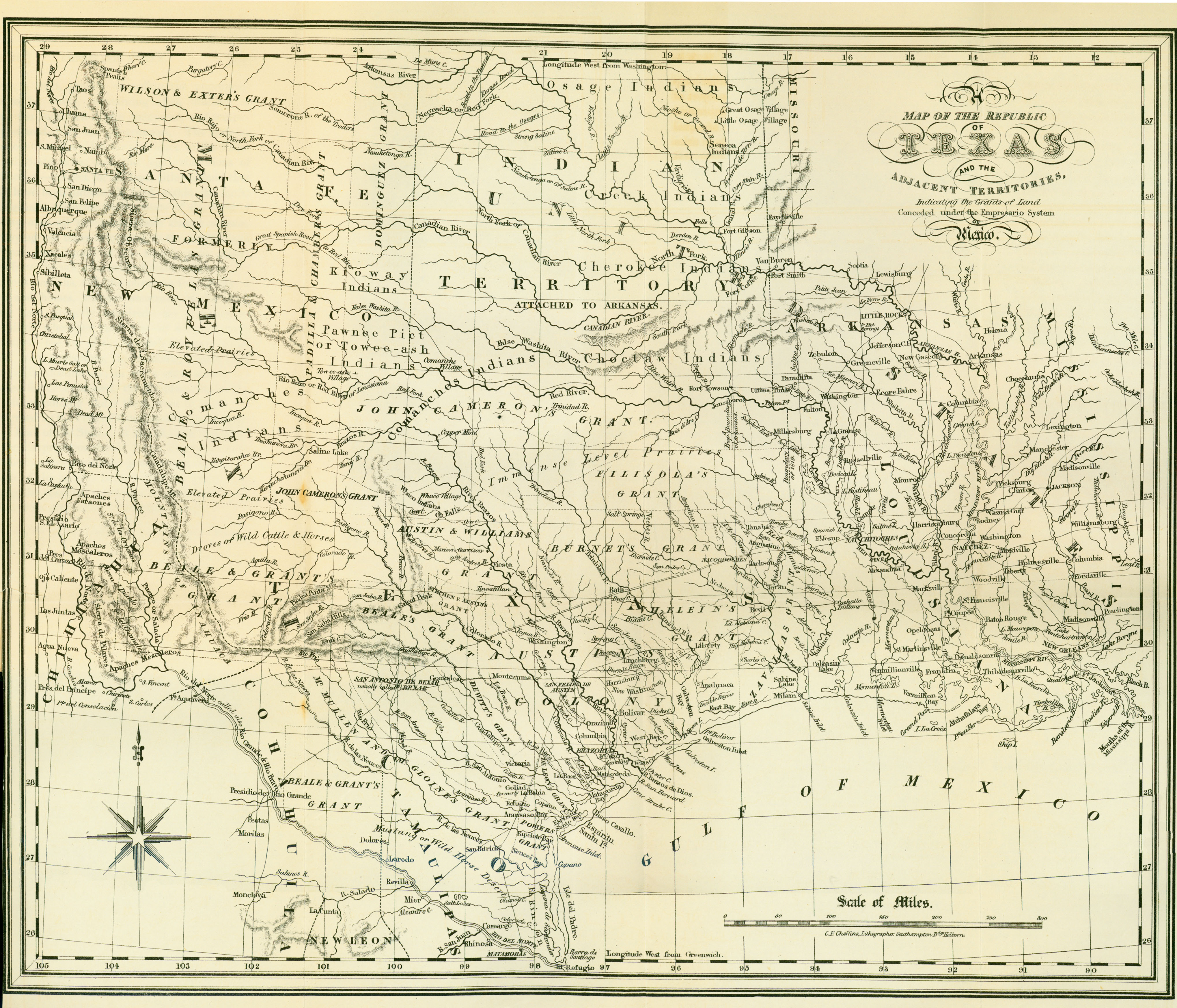
- Texas 1841 (2.8MB)
- A Map of Texas, Compiled from Surveys Recorded in the Land Office of Texas, and Other Official Surveys by John Arrowsmith. From Texas: The Rise, Progress, and Prospects of the Republic of Texas by William Kennedy, 1841. [London] R. Hastings, 1841. Map courtesy Dorothy Sloan-Rare Books, Austin, Texas
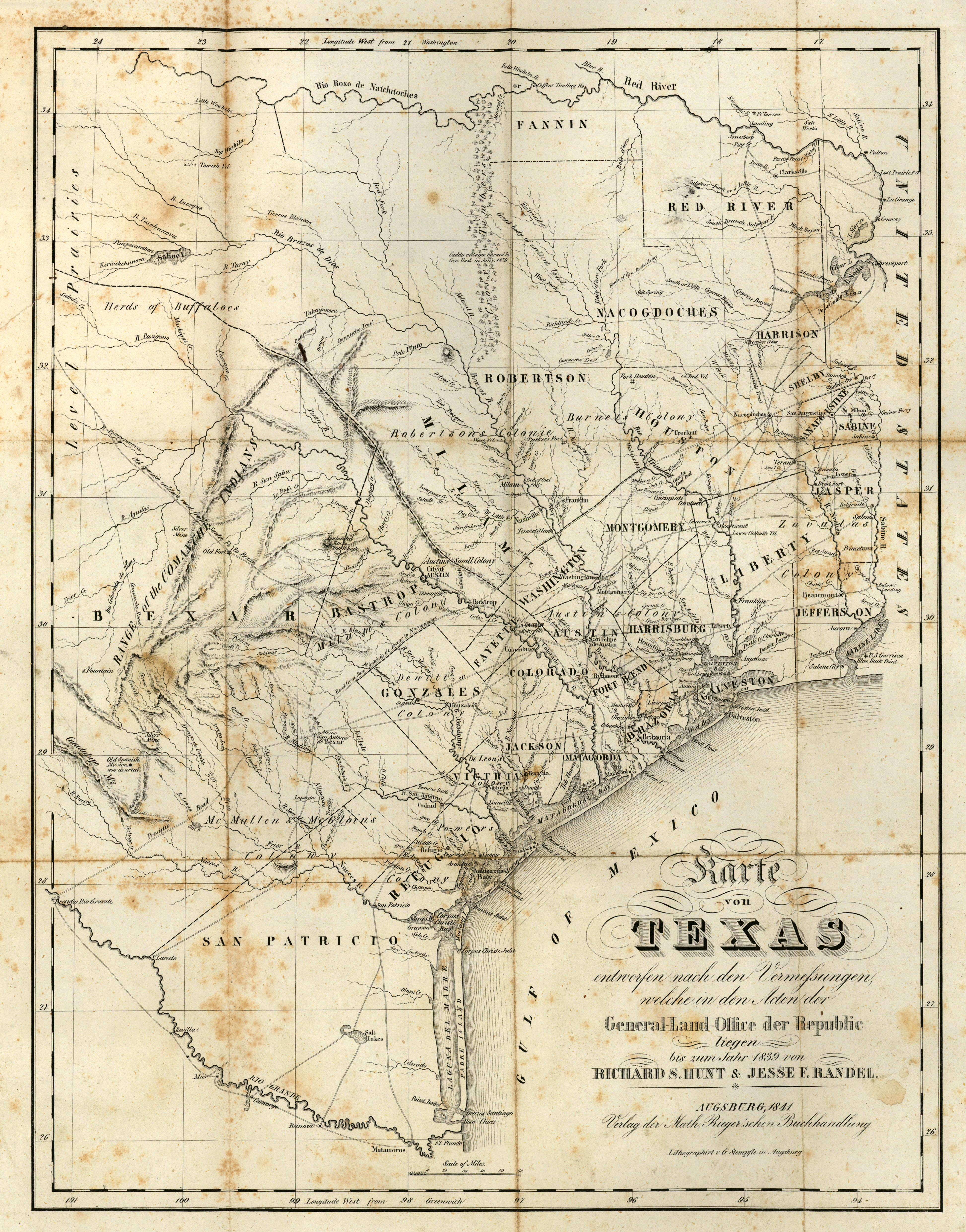
- Texas 1841 (4.1MB)
- "Karte von Texas entworfen nach den Vermessungen, welche in den Acten der General-Land-Office der Republic liegen bis zum Jahr 1839 von Richard S. Hunt & Jesse F. Randel". From George A. Scherpf, "Entstehungsgeschichte und gegenw�rtiger Zustand des neuen, unabh�ngigen, amerikanischen Staates Texas. Ein Beitrag zur Geschichte, Statistik und Geographie dieses Jahrhunderts, Im Lande selbst gesammelt von G. A. Scherpf. Mit zwei Karten, von Texas, Rio Grande und dem West-Land am Stillen Ocean". Reduced version of Hunt and Randel�s 1839 map of Texas. One of the earliest representations on a printed map of the newly established town of Austin (1839). Augsburg: Verlag der Matth. Rieger�schen Buchhandlung, 1841. Map courtesy Dorothy Sloan-Rare Books, Austin, Texas
- Texas Frontier Development 1841-1843 (97K)
- From Atlas of Texas. Published by The University of Texas at Austin, Bureau of Business Research, 1976.
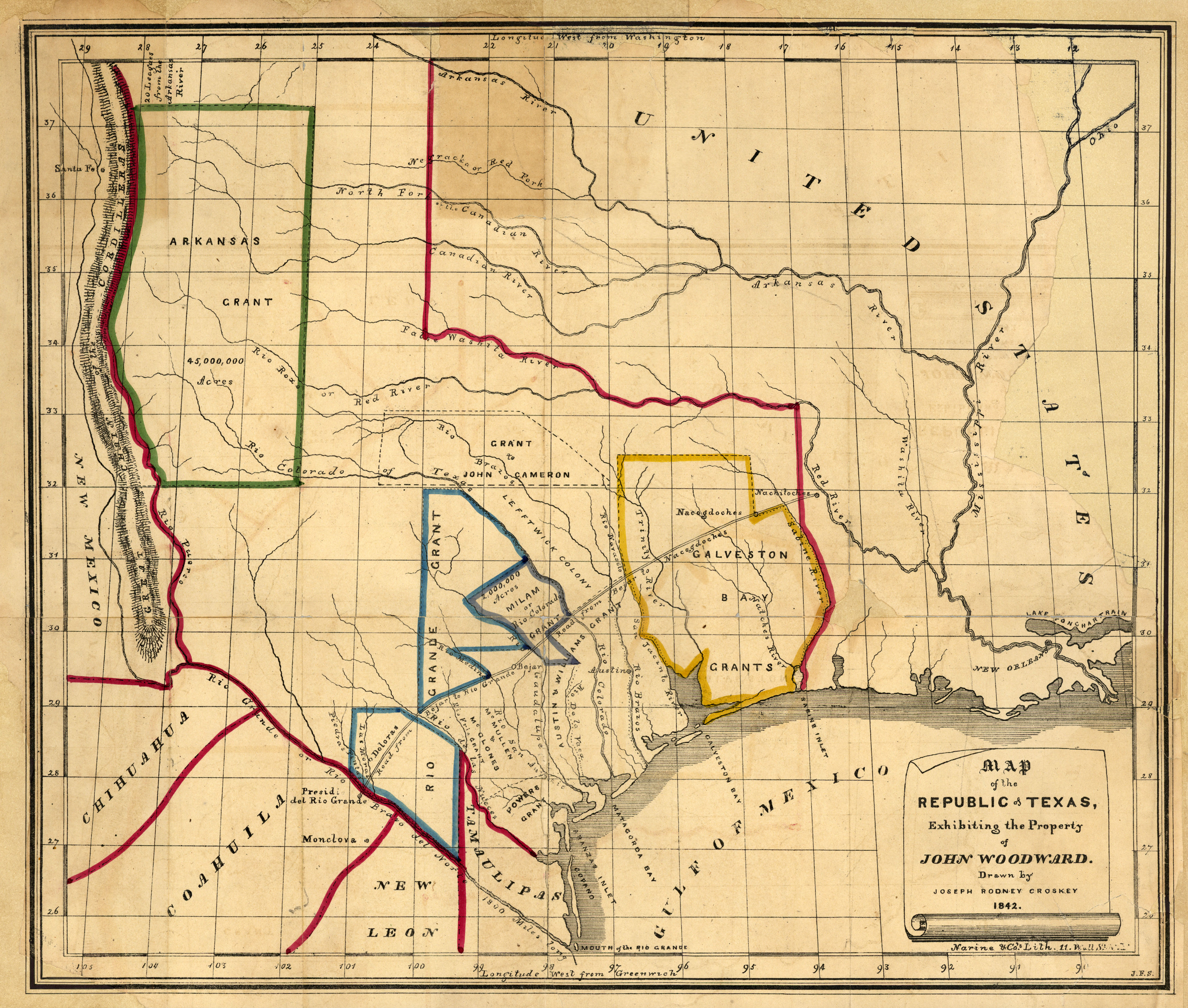
- Texas 1842 (3.2MB)
- "Map of the Republic of Texas, Exhibiting the Property of John Woodward. Drawn by Joseph Rodney Croskey 1842. Narine & Co�s. Lith. New York, 1842. The map appeared in the following pamphlet by John Woodward: "An Abstract of the Constitutions, Laws and Other Documents Having Reference to, and including the Empresario Grants and Contracts made by the State of Coahuila and Texas to and with John Charles Beales..." (New York: Narine & Co�s Print, 1842). Information about Woodward is in the Handbook of Texas Online. Map courtesy Dorothy Sloan-Rare Books, Austin, Texas
- Mexico 1842 [includes Texas] (2.8MB)
- From Mexico in 1842: A Description of the Country, Its Natural and Political Features...by George Folsom. New York: Charles J. Folsom; Wiley and Putnam; Robinson, Pratt and Co., 1842. Map courtesy Dorothy Sloan-Rare Books, Austin, Texas
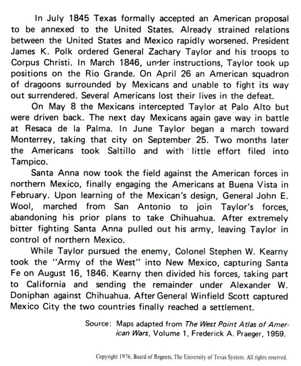
Mexican War 1846-1848:
- Mexican War Maps 1846-1848 (Antonio Rafael de la Cova)
- Mexican War Battles in Texas and Northern Mexico, 1846-1847 - Text Description from Atlas of Texas
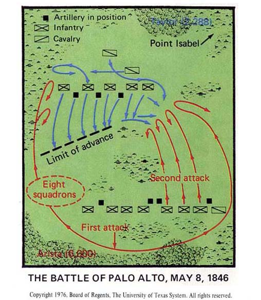
- The Battle of Palo Alto, May 8, 1846 (62K)
- From Atlas of Texas. Published by The University of Texas at Austin, Bureau of Business Research, 1976.
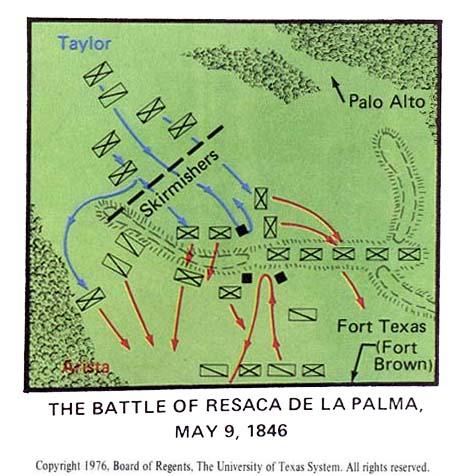
- The Battle of Resaca De La Palma, May 9, 1846 (50K)
- From Atlas of Texas. Published by The University of Texas at Austin, Bureau of Business Research, 1976.
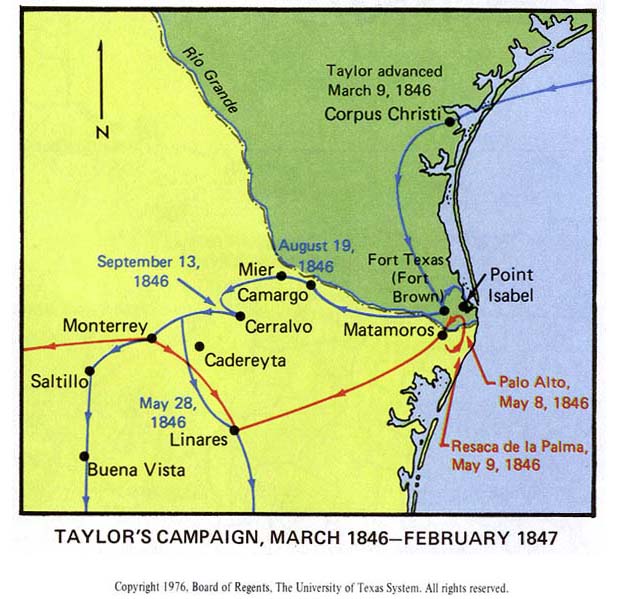
- Taylor's Campaign, March 1846 - February 1847 (69K)
- From Atlas of Texas. Published by The University of Texas at Austin, Bureau of Business Research, 1976.
- Stephen Kearny's Campaign in New Mexico and A.W. Doniphan's Campaign in Chihuahua [1846-1847] (147K)
- From Atlas of Texas. Published by The University of Texas at Austin, Bureau of Business Research, 1976.
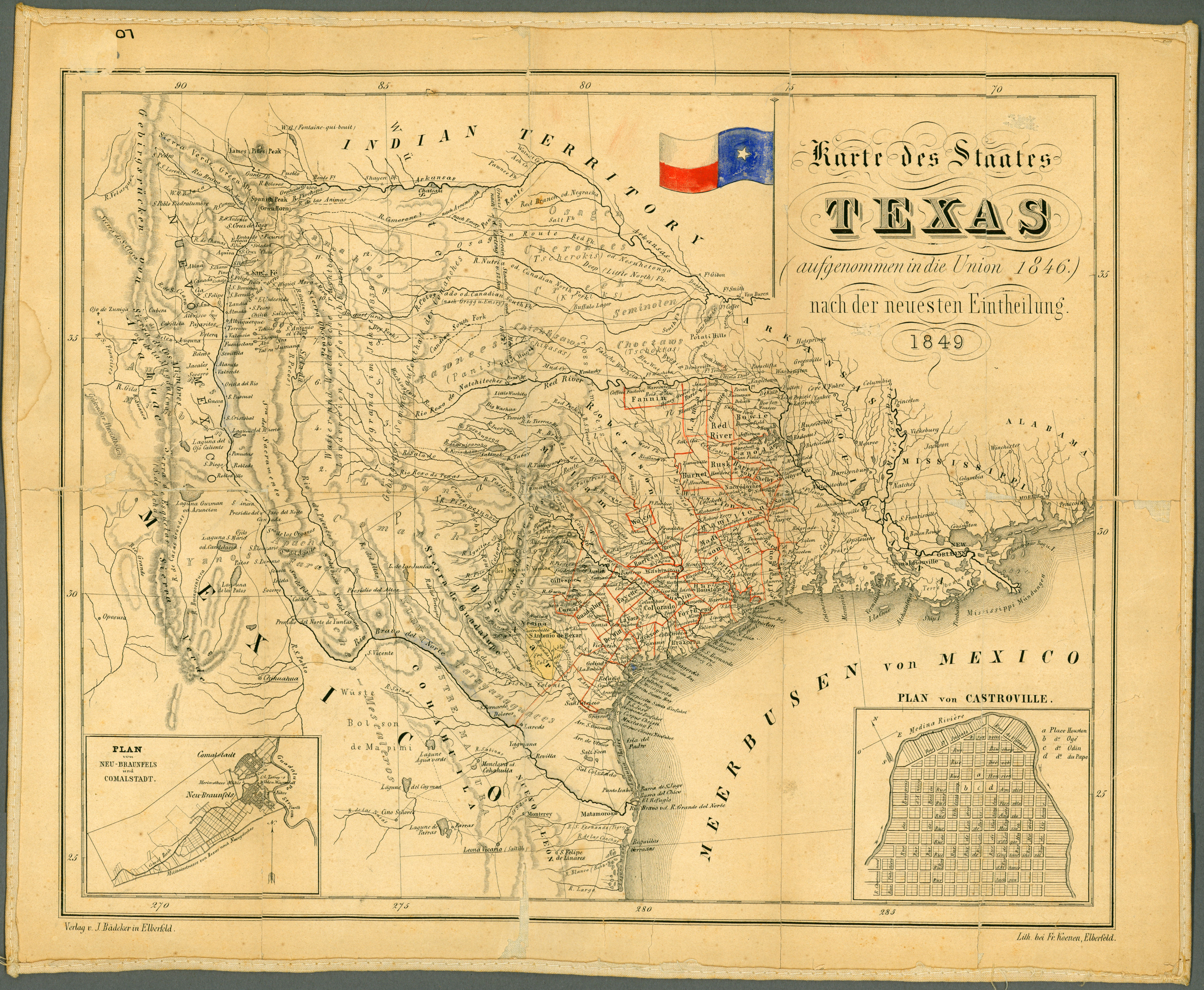
- Texas 1849 (4.6MB)
- Karte des Staates Texas (aufgenommen in die Union 1846.) nach der neuesten Eintheilung. by J. Bädeker. Verlag v. J. Bädeker in Elberfeld, 1849. Map courtesy Dorothy Sloan-Rare Books, Austin, Texas
1848-1860:
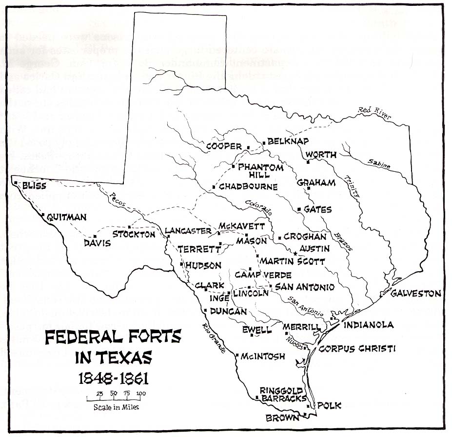
- Texas - Federal Forts 1848-1861 (124K)
- From History of Fort Davis, Texas by Robert Wooster; Southwest Cultural Resources Center Professional Papers Number 34. 1990.
- Texas Frontier 1849-1852 (Texas Beyond History)
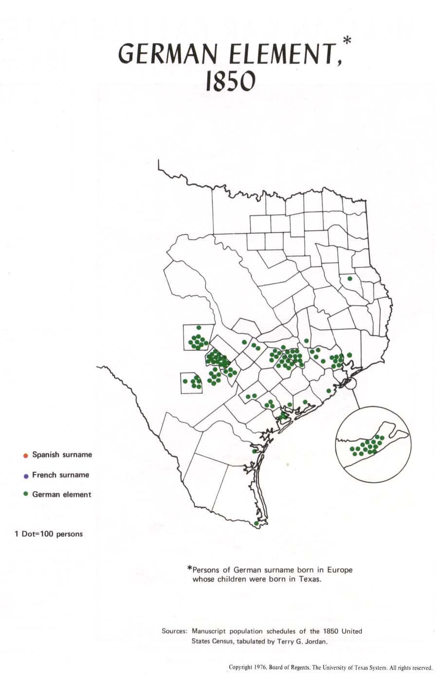
- German Element, 1850 (79K)
- From Atlas of Texas. Published by The University of Texas at Austin, Bureau of Business Research, 1976.
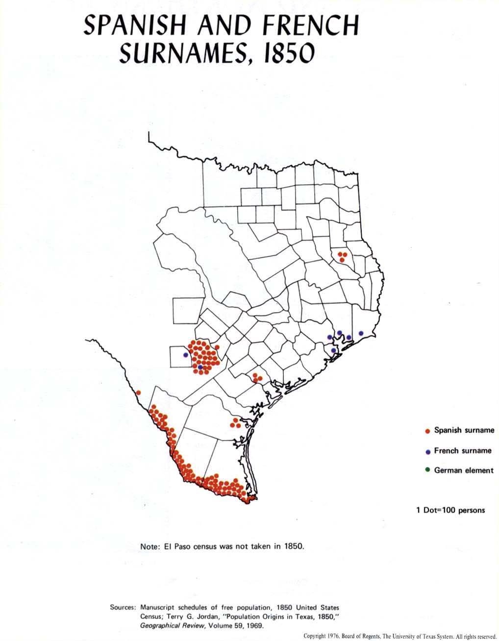
- Spanish and French Surnames, 1850 (81K)
- From Atlas of Texas. Published by The University of Texas at Austin, Bureau of Business Research, 1976.
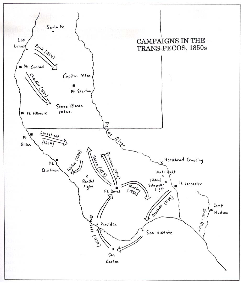
- Campaigns in the Trans-Pecos 1850's (91K)
- From History of Fort Davis, Texas by Robert Wooster; Southwest Cultural Resources Center Professional Papers Number 34. 1990.
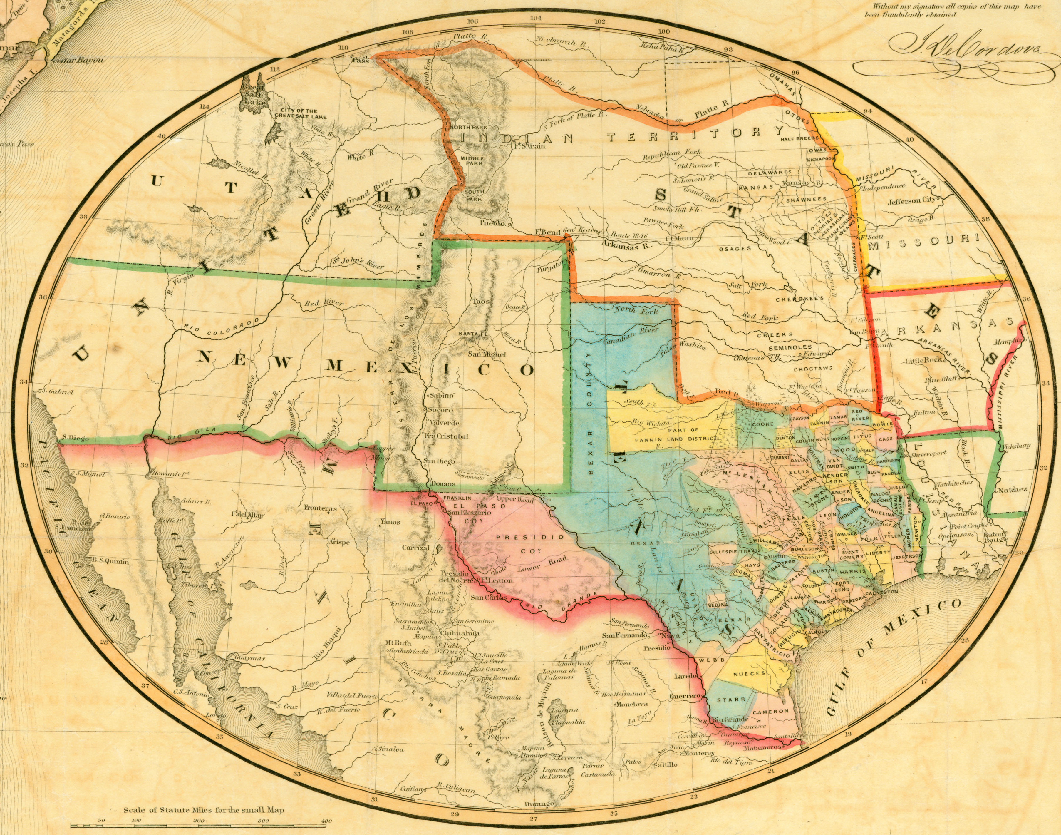
- Texas 1851 (2MB)
- Inset from "J. De Cordova�s Map of the State of Texas Compiled from the Records of the General Land Office of the State, by Robert Creuzbaur, Houston, 1851..." Engraved by J. M. Atwood, New York. Map courtesy Dorothy Sloan-Rare Books, Austin, Texas
- Texas 1856 (David Rumsey Collection)
- J. De Cordova's Map Of The State Of Texas. New York: J.H. Colton & Co., 1856
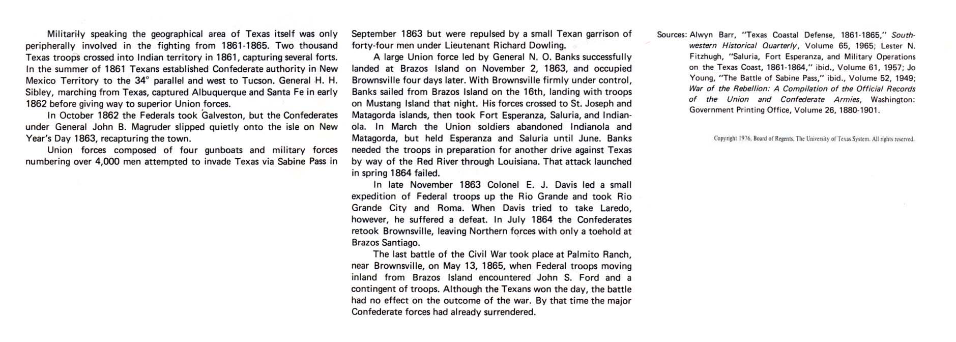
Civil War, 1861-1865:
- Federal Military Activity in Texas, 1861-1865 - Text Description from Atlas of Texas
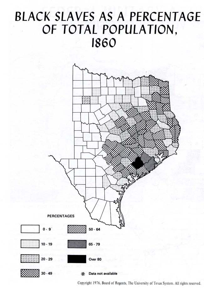
- Black Slaves as a Percentage of Total Population 1860 (96K)
- From Atlas of Texas. Published by The University of Texas at Austin, Bureau of Business Research, 1976.
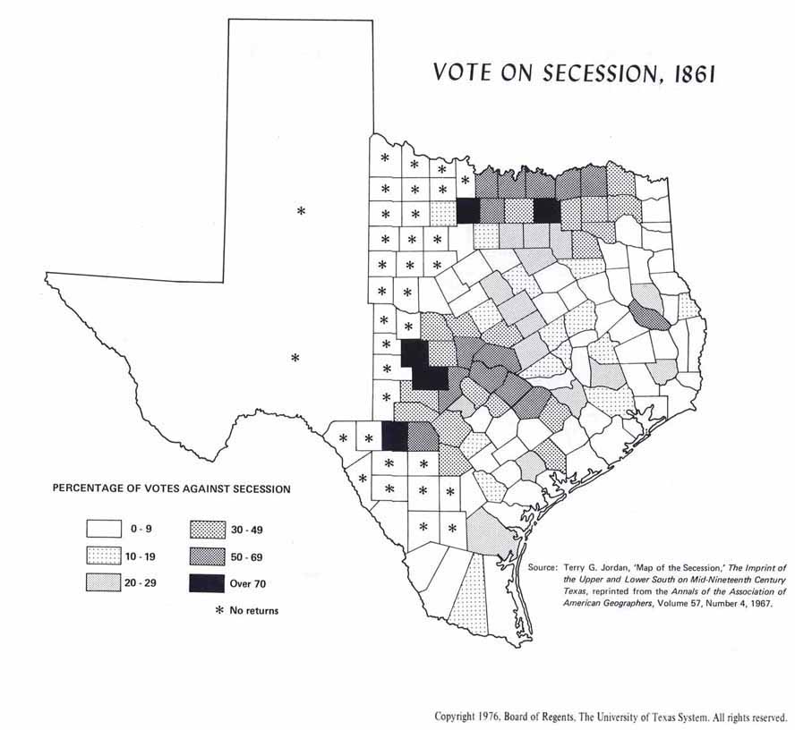
- Vote on Secession, 1861 (204K)
- From Atlas of Texas. Published by The University of Texas at Austin, Bureau of Business Research, 1976.
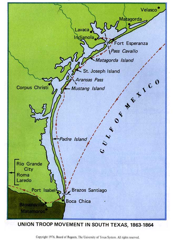
- Union Troop Movement in South Texas, 1863-1864 (91K)
- From Atlas of Texas. Published by The University of Texas at Austin, Bureau of Business Research, 1976.
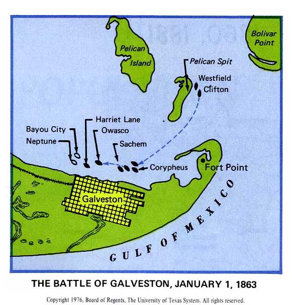
- The Battle of Galveston, January 1, 1863 (66K)
- From Atlas of Texas. Published by The University of Texas at Austin, Bureau of Business Research, 1976.
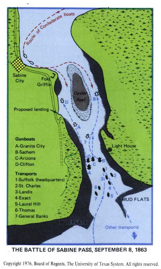
- The Battle of Sabine Pass, September 8, 1863 (78K)
- From Atlas of Texas. Published by The University of Texas at Austin, Bureau of Business Research, 1976.
Late 19th Century:
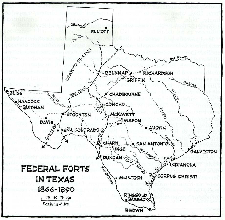
- Texas 1866-1890 Federal Forts (132K)
- From History of Fort Davis, Texas by Robert Wooster; Southwest Cultural Resources Center Professional Papers Number 34. 1990.
- Frontier Federal Forts and Cattle Trails [1867-1886] (232K) Larger JPEG Image (368K)
- From Atlas of Texas. Published by The University of Texas at Austin, Bureau of Business Research, 1976.
- Texas Frontier Forts Post-Civil War (Texas Beyond History)
- [Texas Cattle Trails] "The Best and Shortest Route from Texas", Kansas Pacific Railway, 1872 (2.4 MB)
- Cattle trails are in red. Map courtesy Dorothy Sloan-Rare Books, Austin, Texas
- Cattle Trails (Texas Beyond History)
- Texas 1873 Railway Map (Library of Congress, Geography and Map Division)
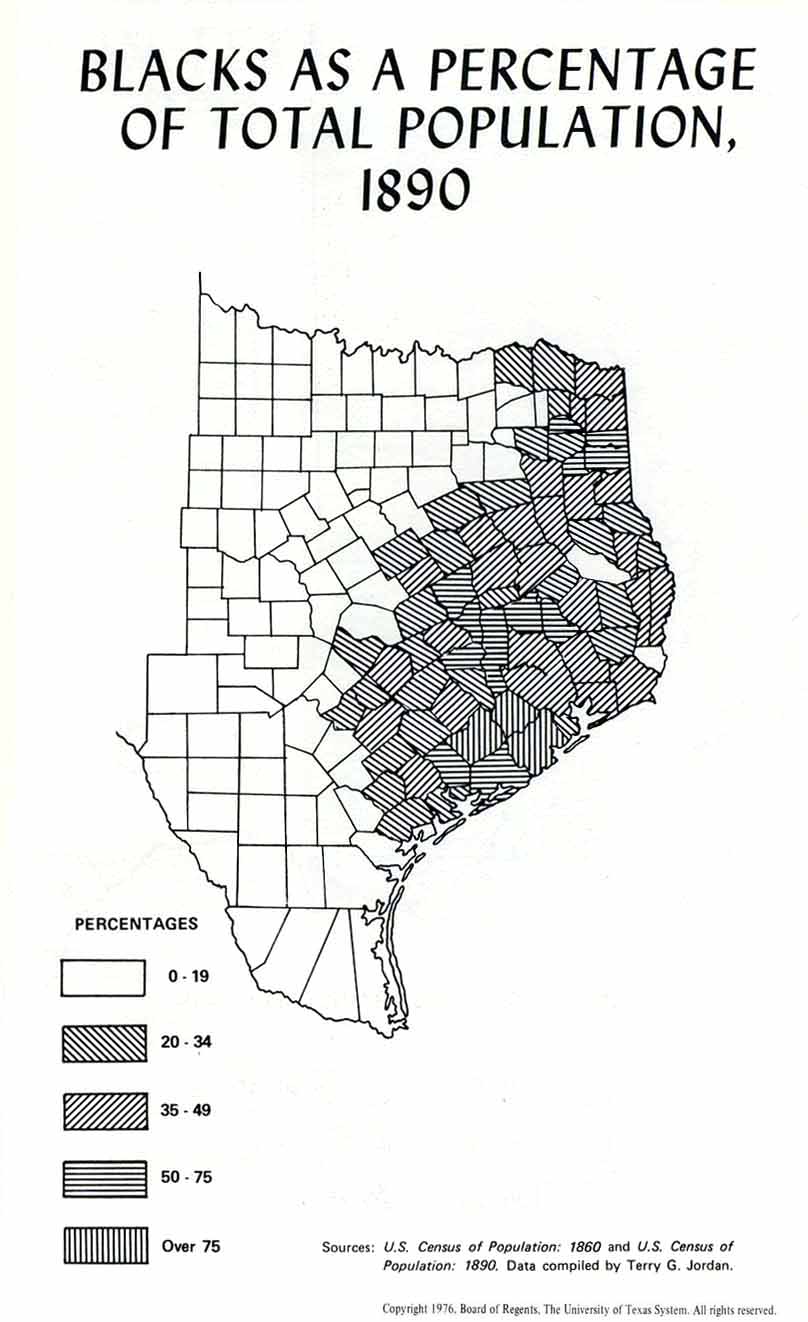
- Blacks as a Percentage of Total Population, 1890 (95K)
- From Atlas of Texas. Published by The University of Texas at Austin, Bureau of Business Research, 1976.
- Texas 1895 (LivGenMI)
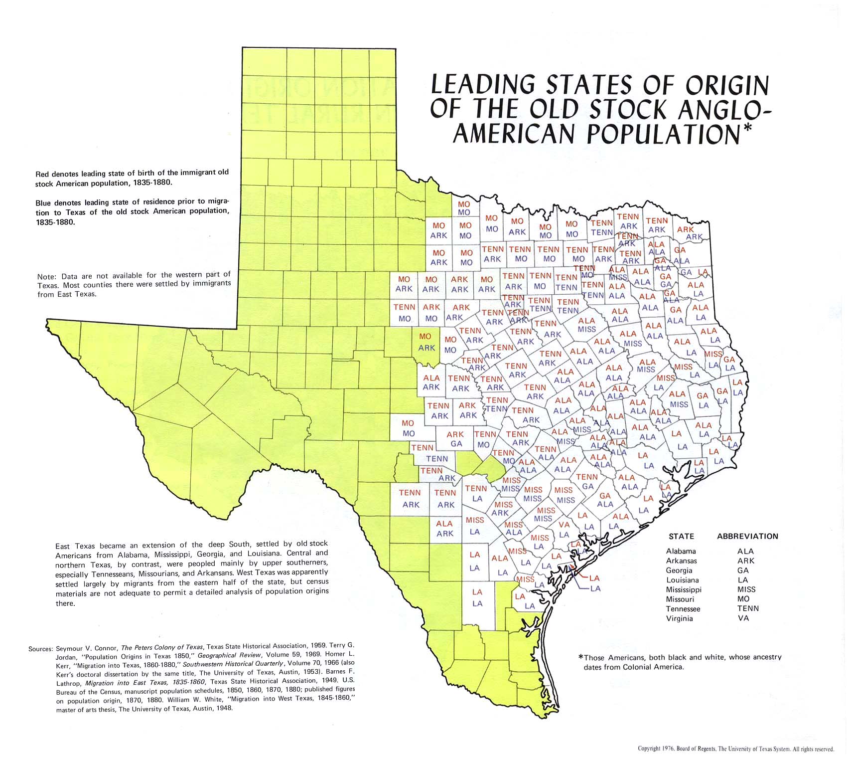
- Leading States of Origin of the Old Stock Anglo-American Population (293K)
- From Atlas of Texas. Published by The University of Texas at Austin, Bureau of Business Research, 1976.
20th Century:
- Texas 1900 Railway Map (Library of Congress, Geography and Map Division)
- Jefferson and Hardin County Oil Fields 1901 (404K)
- From Houston Daily Post, May 12, 1901 (Chronicling America) [pdf format]
- Spindletop Oil Field 1901 (990K)
- From Houston Daily Post, November 3, 1901 (Chronicling America) [pdf format]
- Rio Grande, Roma to the Gulf of Mexico 1910-1911
- Maps from Survey of the Rio Grande, Roma to the Gulf of Mexico : Reports and Maps.
Proceedings of the International Boundary Commission, United States and Mexico : American Section :
Joint Report of the Consulting Engineers on Field Operations of 1910-1911. U.S. Department of State [1913].
- Texas 1917 (717K)
- From The New Encyclopedic Atlas and Gazetteer of the World, 1917 (PCL Map Collection)
- Texas - 1920 Military Bases (RootsWeb)
- Texas and U.S. - Aeronautical Charts 1923-1932
Other Historical Texas Maps:
- Portal to Texas History
- Texas Beyond History (University of Texas at Austin, College of Liberal Arts)
- Texas General Land Office - Maps
- Texas Historic Sites Atlas (Texas Historical Commission)
- Texas Historic Maps (University of South Florida)
- Texas Historical City Maps (PCL Map Collection)
- Texas Historical Maps (University of Alabama Historical Map Archive)
- Texas Sanborn Fire Insurance Maps (Pre-1923) (PCL Map Collection)
- Texas State Library Map Search (Texas State Library and Archives Commission)
- Texas Topographic Maps (PCL Map Collection)
Note: Maps on this page from publications of The University of Texas at Austin, Bureau of Business Research
are Copyright, Board of Regents, The University of Texas System.
For information on using these maps, see the
Materials Usage Statement page.
![Champ d'Asile [French Settlement] 1819](http://maps.lib.utexas.edu/maps/historical/champ_dasile-hartmann-le_texas-03.jpg)
![Mexico 1842 [includes Texas]](http://maps.lib.utexas.edu/maps/historical/folsom-mexico_in_1842-01.jpg)
![Stephen Kearny's Campaign in New Mexico and A.W. Doniphan's Campaign in Chihuahua [1846-1847]](http://maps.lib.utexas.edu/maps/atlas_texas/kearny_doniphan_campaigns.jpg)
![Frontier Federal Forts and Cattle Trails [1867-1886]](http://maps.lib.utexas.edu/maps/atlas_texas/texas_frontier_forts.jpg)
![[Texas Cattle Trails] "The Best and Shortest Route from Texas", Kansas Pacific Railway, 1872](http://maps.lib.utexas.edu/maps/historical/texas-best_and_shortest_route_from-1872.jpg)