Perry-Castañeda Library
Map Collection
Historical Maps of The Balkans
These are in chronological order: Ancient and Medieval:
- Macedonia, Thracia, Illyria, Moesia et Dacia [Ancient Balkans] (722K)
- Map from "A Classical Atlas to Illustrate Ancient Geography" by Alexander G. Findlay, Harper and Brothers Publishers, New York, 1849.
- Europe - Crusades Era [includes Balkans] (253K)
- From "The Public Schools Historical Atlas" edited by C. Colbeck, published by Longmans, Green, and Co., 1905.
- Boundaries of Serbia [from 1196-present] (54K)
- Map from "Kosovo: History of a Balkan Hot Spot", U.S. Central Intelligence Agency, Office of DCI Interagency Balkan Task Force, June 1998.
![Macedonia, Thracia, Illyria, Moesia et Dacia [Ancient Balkans]](macedonia_1849.jpg)
![Europe - Crusades Era [includes Balkans]](crusades_1905.jpg)
![Boundaries of Serbia [from 1196-present]](serbia_boundaries.gif)
- Europe about 1560 [includes Balkans] (941K)
- Map from "Historical Atlas" by William R. Shepherd, 1923.
![Europe about 1560 [includes Balkans]](europe1560_shepherd.jpg)
- Dismemberment of the Ottoman Empire [1683-1923] (649K)
- Map from "Historical Atlas" by William R. Shepherd, 1923.
![Dismemberment of the Ottoman Empire [1683-1923]](ottoman1683_shepherd.jpg)
- Europe 1815 [includes Balkans] (294K)
- From "The Public Schools Historical Atlas" edited by C. Colbeck, published by Longmans, Green, and Co., 1905.
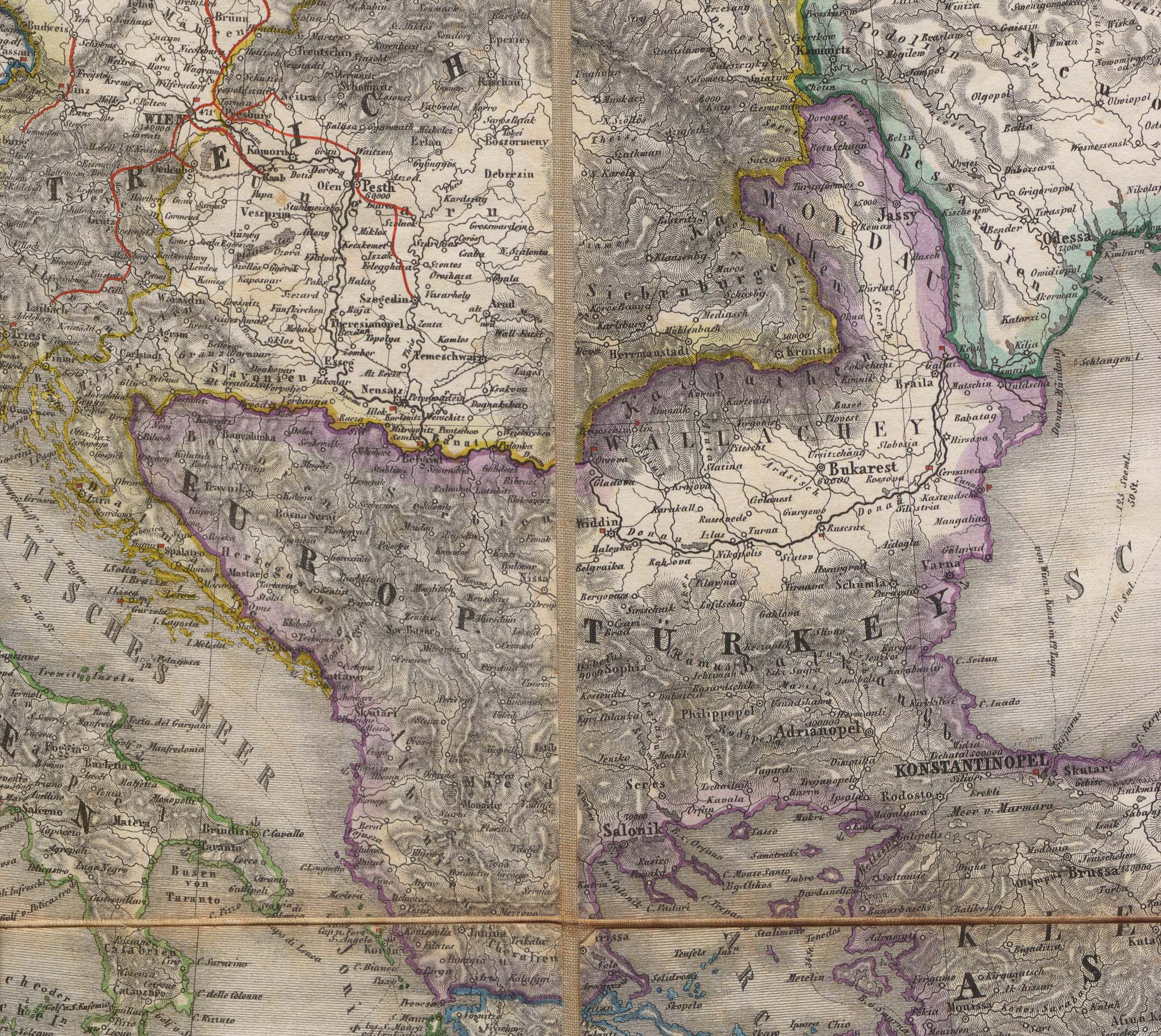
- Balkans 1856 (972K)
- Portion of "Karte von Europa mit Nord-Afrika" Georg Mayr, 1856.
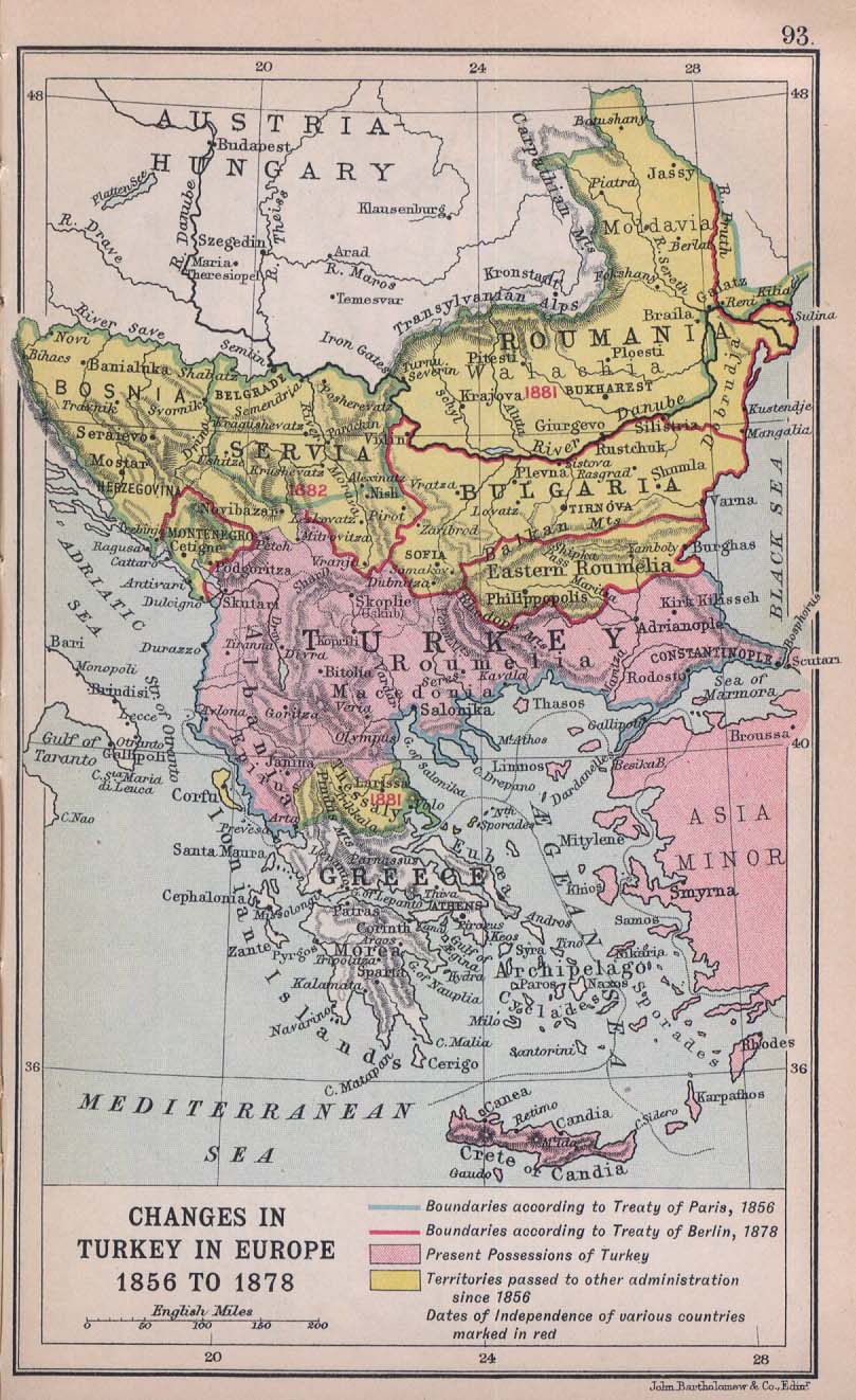
- Changes in Turkey in Europe 1856 to 1878 (201K)
- From "Literary and Historical Atlas of Europe", by J.G. Bartholomew, 1912.
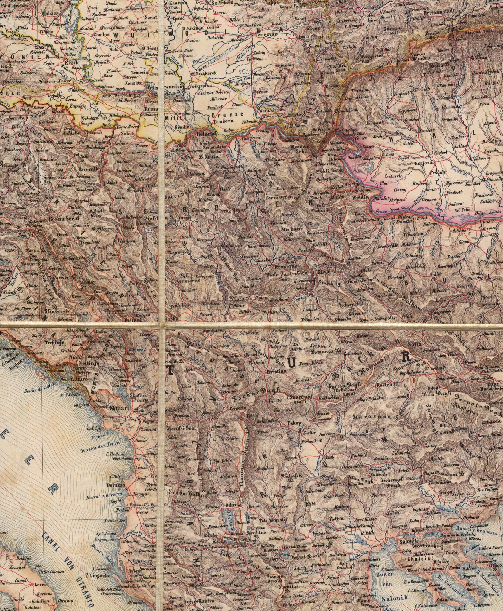
- Balkans 1859 (888K)
- Portion of "General-Karte von Europa" by J. Scheda, 1859.
- Historical Borders: Vojvodina [1867-1992] (126K)
- Map from "Former Yugoslavia: A Map Folio", U.S. Central Intelligence Agency, 1992.
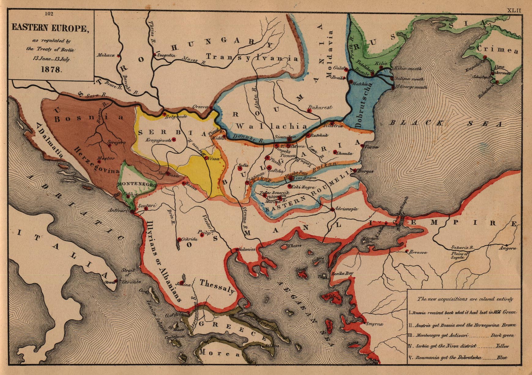
- Eastern Europe 1878 (468K)
- Map from "An Historical Atlas" by Robert H. Labberton, E. Elaxton and Co., 1884.
- Bulgaria after the Conference of Constantinople 1876-1877 (124K)
- Map from "Report of the International Commission To Inquire into the Causes and Conduct of the Balkan Wars" 1914.
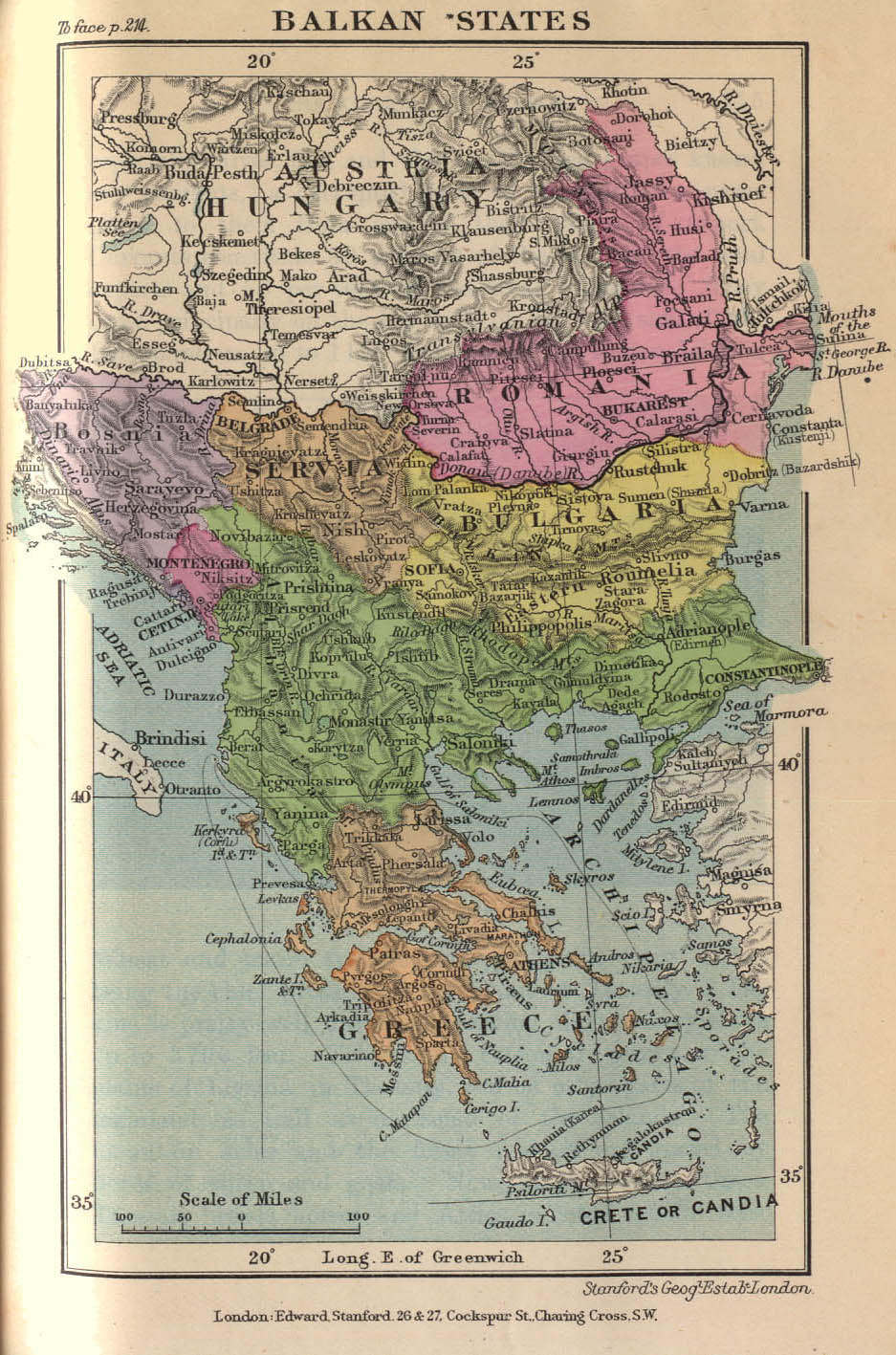
- Balkan States 1899 (304K)
- Map from "Stanford's Compendium of Geography and Travel: Europe" Volume 1, 1899.
![Europe 1815 [includes Balkans]](europe1815_1905.jpg)
![Historical Borders: Vojvodina [1867-1992]](/maps/europe/vojvodina_history92.jpg)
- Belgrad [Belgrade] 1905 (371K)
- Map From "Austria-Hungary Including Dalmatia and Bosnia. Handbook For Travellers" by Karl Baedeker, 1905.
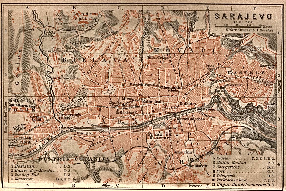
- Sarajevo 1905 (325K)
- Map From "Austria-Hungary Including Dalmatia and Bosnia. Handbook For Travellers" by Karl Baedeker, 1905.
- Contested Regions according to the map annexed to the Treaty of Alliance [1912] (262K)
- Map from "Report of the International Commission To Inquire into the Causes and Conduct of the Balkan Wars" 1914. "The Serbian-Bulgarian treaty of 13 March 1912 made provision for the partition of Macedonia along the following lines: 'all the territory north of the Sar range' was to go to Serbia; 'all the region east of the Rhodope range and the Struma valley' was to go to Bulgaria. Bulgaria hoped the intervening country should form an 'autonomous Macedonia', but, if this should prove impossible, a new line was to be drawn leaving Kumanovo, Skoplje and Debar to Serbia, and giving Kratovo, Veles, Bitolj (Monastir) and Ohrid to Bulgaria. Serbia undertook to make no claim south of the line; Bulgaria reserved the right to claim territory to the north, in which case Russia was to act as arbitrator. The area of overlapping claims was known as the 'Contested Zone'. "--quote from: Great Britain. Naval Intelligence Division, Geographical Handbook Series: Jugoslavia, Volume II, 1944, p. 114.
- Balkan Aspirations [showing boundaries of 1912] (153K)
- Map from "Report of the International Commission To Inquire into the Causes and Conduct of the Balkan Wars" 1914. "There was hardly any part of the territory of Turkey in Europe which was not claimed by at least two competitors."--Report of the International Commission To Inquire into the Causes and Conduct of the Balkan Wars, Carnegie Endowment for International Peace, 1914, p.38.
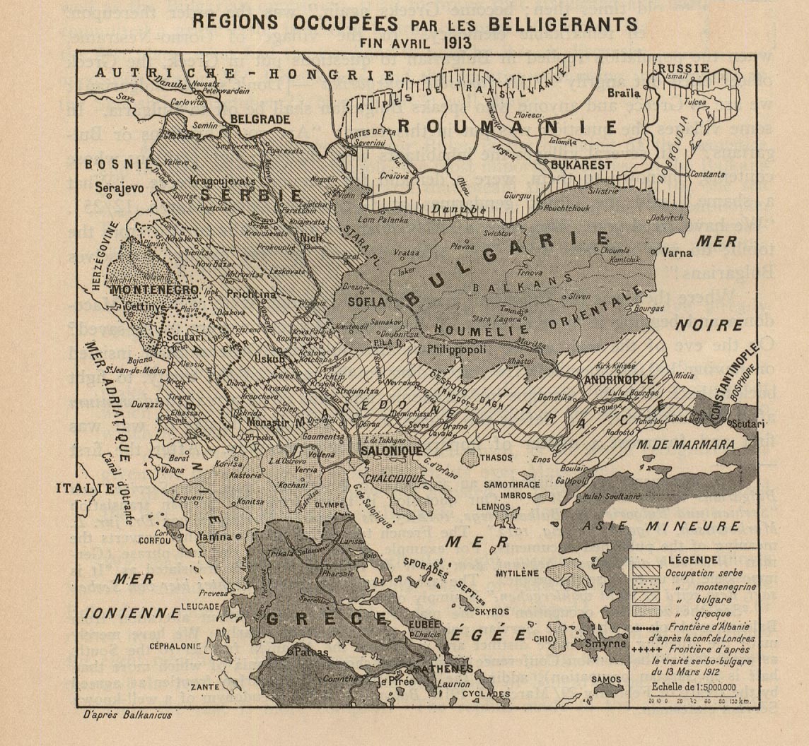
- Regions Occupees par les Belligerants fin Avril 1913 (365K)
- Map from "Report of the International Commission To Inquire into the Causes and Conduct of the Balkan Wars" 1914. [This map shows areas occupied by Balkan armies at the end of April 1913: (Serbian, Montenegrin, Bulgarian, Greek)]. "War began with the declaration of Montenegro on 8 October [1912], and, within a few months, to the amazement of Europe, the Turkish forces had collapsed."--quote from: Great Britain. Naval Intelligence Division, Geographical Handbook Series: Jugoslavia, Volume II, 1944, p. 114.
- Territorial Modifications in the Balkans - Conference of London [May 1913] and Treaty of Bukarest [August 1913] (281K)
- Map from "Report of the International Commission To Inquire into the Causes and Conduct of the Balkan Wars" 1914. "The Treaty of London (30 May 1913) ceded to the Balkan allies all territories 'west of a line drawn from Enos on the Aegean Sea to Midia on the Black Sea, with the exception of Albania. It was not only a defeat of the military forces of the Turkish empire, but a defeat of the Austrian dream of Drang nach Osten. ...Austria-Hungary and Italy, rather than see Albania partitioned between Slav states on the north and Greece on the south, had succeeded in blocking Serbian access to the Adriatic by proposing the creation of an autonomous Albania." --quote from: Great Britain. Naval Intelligence Division, Geographical Handbook Series: Jugoslavia, Volume II, 1944, p. 114.
- Historical Borders: Kosovo [1913-1992] (218K)
- Map from Former Yugoslavia: A Map Folio, U.S. Central Intelligence Agency 1992.
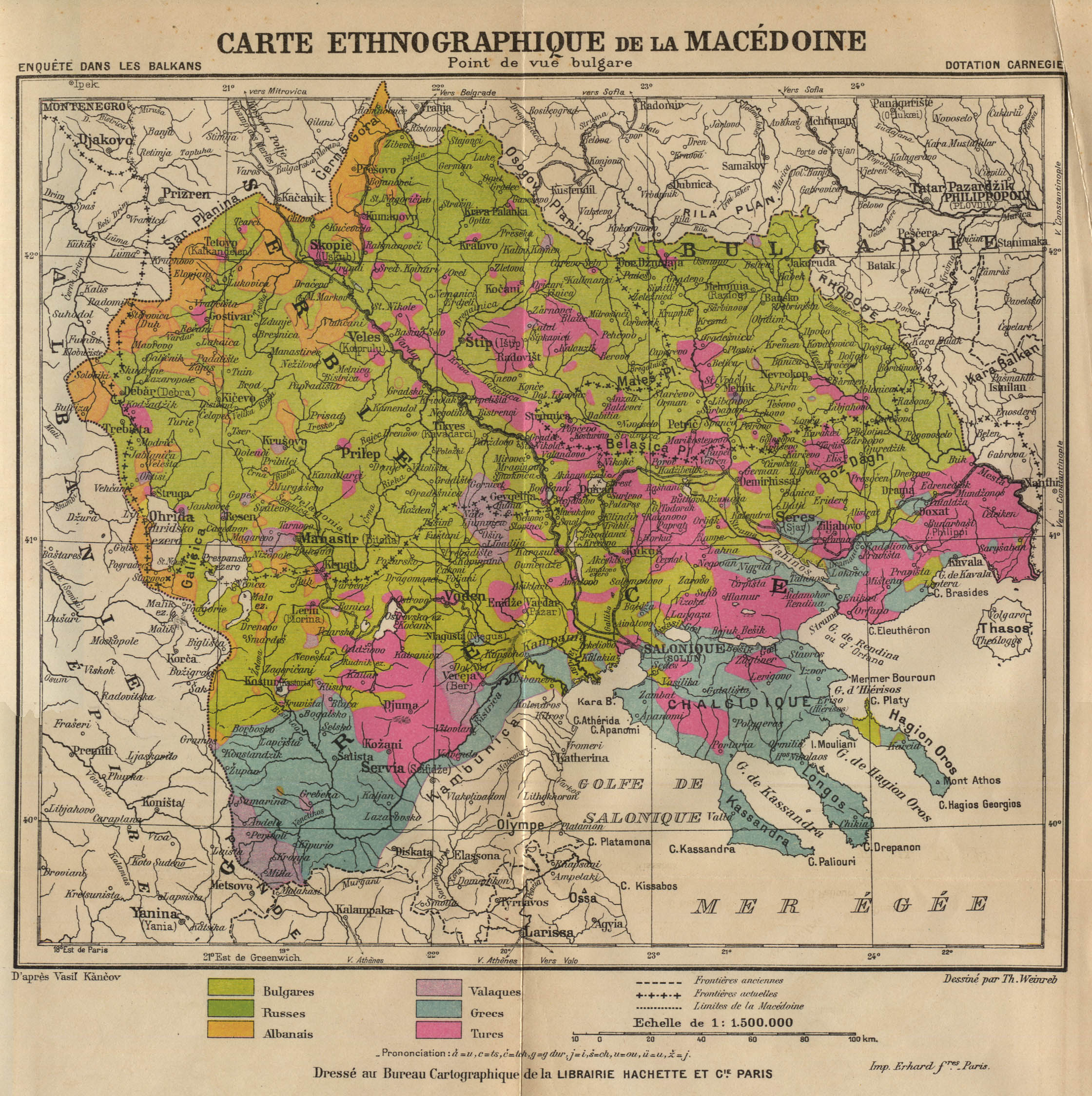
- Carte Ethnographique de la Macedoine: Point de vue bulgare (998K)
- [Ethnographic map of Macedonia from the point of view of the Bulgarians]. Map from "Report of the International Commission To Inquire into the Causes and Conduct of the Balkan Wars" 1914.
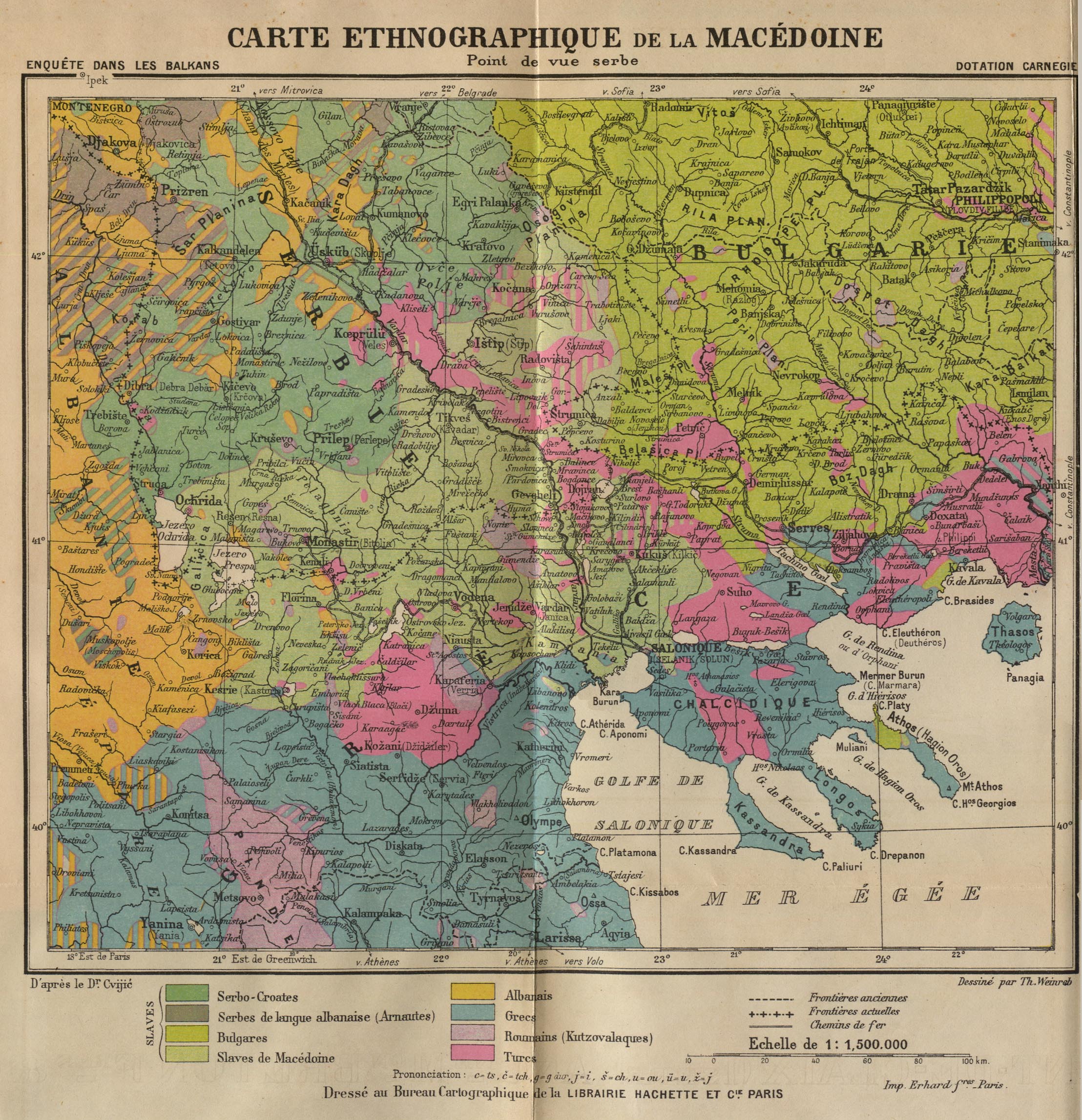
- Carte Ethnographique de la Macedoine: Point de vue serbe (992K)
- [Ethnographic map of Macedonia from the point of view of the Serbs]. Map from "Report of the International Commission To Inquire into the Causes and Conduct of the Balkan Wars" 1914.
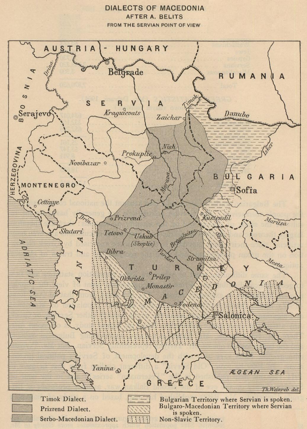
- Dialects of Macedonia From the Servian Point of View (248K)
- Map from "Report of the International Commission To Inquire into the Causes and Conduct of the Balkan Wars" 1914.
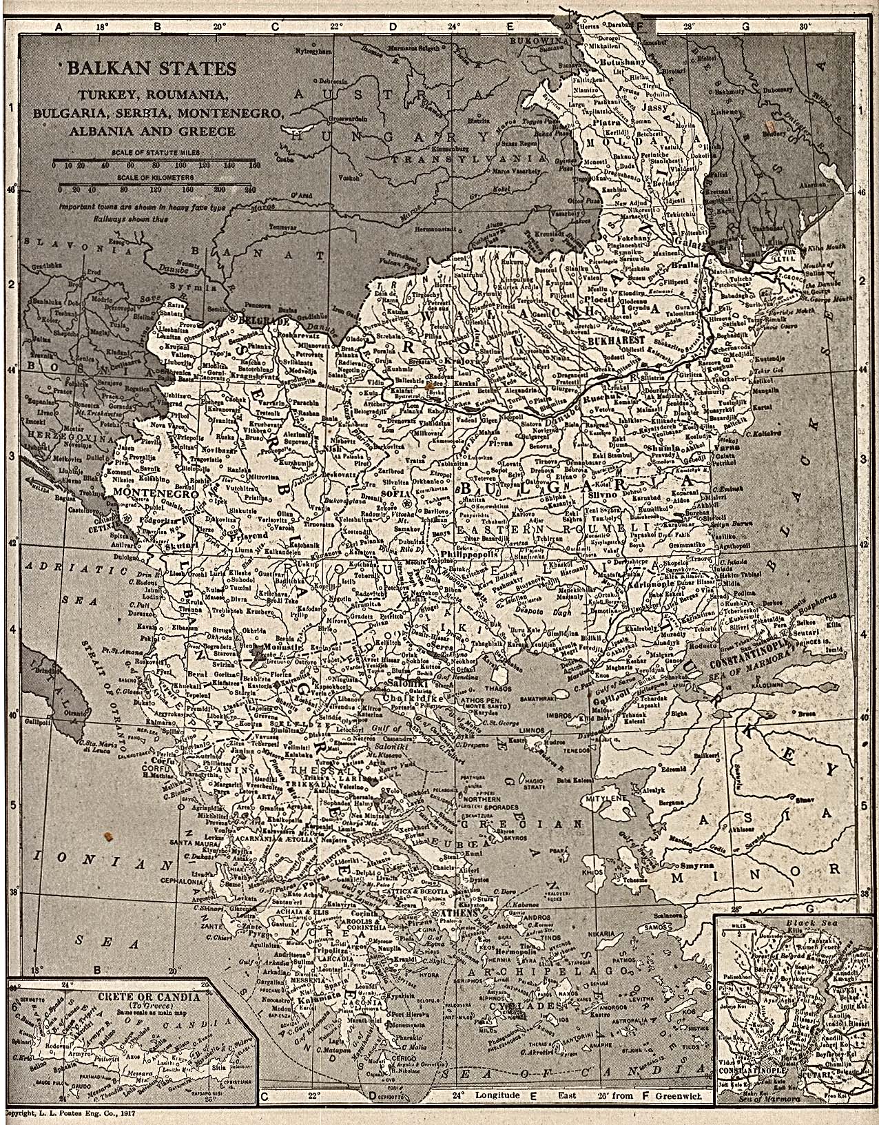
- Balkan States: Turkey, Roumania, Bulgaria, Serbia, Montenegro, Albania and Greece 1917 (860K)
- From "The New Encyclopedic Atlas And Gazetteer Of The World", edited and revised by Francis J. Reynolds, P.F. Collier and Son Publishers, New York, 1917.
![Belgrad [Belgrade] 1905](belgrad_1905.jpg)
![Contested Regions according to the map annexed to the Treaty of Alliance [1912]](balkan_contested_1914.jpg)
![Balkan Aspirations [showing boundaries of 1912]](balkan_aspirations_1914.jpg)
![Territorial Modifications in the Balkans - Conference of London [May 1913] and Treaty of Bukarest [August 1913]](balkan_modifications_1914.jpg)
![Historical Borders: Kosovo [1913-1992]](/maps/europe/kosovo_history92.jpg)
- Sarajevo: The JNA Attacks, 2 May 1992 (164K)
- Map G from Balkan Battlegrounds: A Military History of the Yugoslav Conflict, 1990-1995. Central Intelligence Agency, Office of Russian and European Analysis. Washington, D.C. 2001.
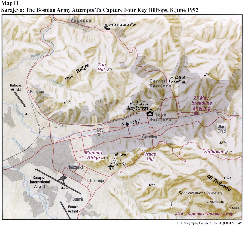
- Sarajevo: The Bosnian Army Attempts to Capture Four Key Hilltops, 8 June 1992 (163K)
- Map H from Balkan Battlegrounds: A Military History of the Yugoslav Conflict, 1990-1995. Central Intelligence Agency, Office of Russian and European Analysis. Washington, D.C. 2001.
- Sarajevo and Vicinity, Early January 1994 (215K)
- Map K from Balkan Battlegrounds: A Military History of the Yugoslav Conflict, 1990-1995. Central Intelligence Agency, Office of Russian and European Analysis. Washington, D.C. 2001.
- Bosnian Army Offensive Operations in Sarajevo Region, June 1995 (238K)
- Map N from Balkan Battlegrounds: A Military History of the Yugoslav Conflict, 1990-1995. Central Intelligence Agency, Office of Russian and European Analysis. Washington, D.C. 2001.
- Additional Maps of Bosnia
Historical Maps of the Balkans on Other Web Sites